
Hikes led by Springwater Trails are generally held on Sunday afternoons and appear in this calendar in green.
| Sun | Mon | Tue | Wed | Thu | Fri | Sat |
|---|---|---|---|---|---|---|
| Hike at Mt. Morris Dam, Mt Morris 2:00 pm Hike at Mt. Morris Dam, Mt Morris @ Mt Morris Dam hike Mar 2 @ 2:00 pm – 4:00 pm 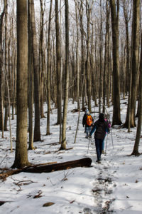 This Sunday, we will hike the Finger Lakes Trail (FLT) starting at the Mt. Morris Dam and Visitors Center Parking Lot. We expect to enjoy the height of winter as we follow the east rim of the Letch worth … Continue reading | ||||||
| Winter Hike, Ski or Snowshoe – All Western Evergreen Farm, Springwater 2:00 pm Winter Hike, Ski or Snowshoe – All Western Evergreen Farm, Springwater @ Liberty Pole Road Mar 9 @ 2:00 pm – 4:00 pm 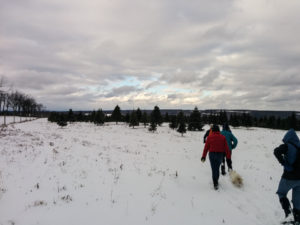 You are invited to hike, ski or snowshoe on a very special private property near the Northwestern corner of Springwater on the 248 acre All Western Evergreen Nursery & Christmas Tree Farm! Note, this hike was rescheduled from 2/16/25 date which … Continue reading | ||||||
| Hike at Sandy Bottom Park, Honeoye 2:00 pm Hike at Sandy Bottom Park, Honeoye Mar 16 @ 2:00 pm – 4:00 pm 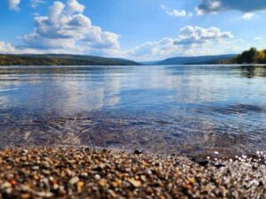 Our hike this Sunday, March 16th will be at Sandy Bottom Nature Trail starting from Main Street across the street from Birdhouse Brewery (8716 Main Street Honeoye, NY 14471). This is where we will park and gather. The hike will … Continue reading | ||||||
| Canadice Westside Trail Hike, Canadice 2:00 pm Canadice Westside Trail Hike, Canadice Mar 23 @ 2:00 pm – 4:00 pm 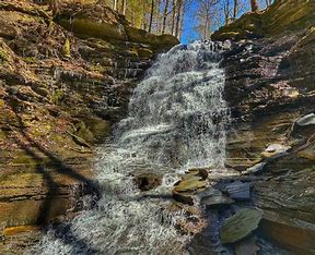 This week’s hike will be on Canadice Lake Trail! This is an easy, 1.8-mile each way hike along the shore of the lake; the trail is level and well-maintained and the lake views are lovely. For most hikers it will … Continue reading | ||||||
| Hike at Affolter’s Family Homestead, Hemlock 2:00 pm Hike at Affolter’s Family Homestead, Hemlock Mar 30 @ 2:00 pm – 4:00 pm 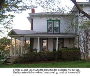 You are invited to hike, on a very special private property at the Affolter family homestead (circa 1900), on Sunday March 30th! The farm, which originally spanned over 360 acres, has been in the Affolter family for over three generations. … Continue reading |
From the south, starting at Bristol Springs for 6.4 miles, come up Route 64 past both Stid Hill parking areas, then turn right on Dugway Road. If you come to Bristol Center you’ve come too far north.
From Springwater, Head north to 20A through Honeoye, then south on 64(see north directions above).
From Wayland, the recommendation is to take Rt 21 through Naples to the east end of Dugway Rd (4.5 miles north of the intersection with NY 64). The trail head is 1.2 miles west on Dugway, (Dugway is paved to the Bristol/Canandaigua town line).
Trail Maps:
NATURALISTS
CLIMBERS
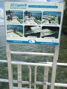
Please join us on August 11 for one of our multi-mode events at Onanda Park on the west side of Canandaigua Lake, 4965 County Road 16, Canandaigua – trail hiking, creek hiking, boating and/or biking. Onanda Park is an 80-acre public property, formerly a YWCA Camp, with 8 acres of level lakefront for water-related recreation and 72 acres of woods and trails on the west side of West Lake Road, including the picturesque Barnes Gully and Barnes Creek. The lakefront and upland sections of the park have different parking fee rules; parking is free in the upland lots, but there is a fee of $10 per car on summer weekends at the lakefront lots. Lakefront walk-ins are free. For details on the park’s facilities, history, and ecosystems, see: http://www.townofcanandaigua.org/portfolio_detail_page.asp?id=5
Meet at 3:45 for a 4 PM start at the upper Upland Parking lot, where we will get organized into groups according to your preferred activity. Hikers will divide into the Climbers and the Tourists/Naturalists, cyclists will head out from here and boaters will drive down to the lakefront lot for easier access to the lake (note the $10/car fee) or walk their boats in. We will reassemble at the cars at 6:00 for our dish-to-pass social in one of the upland lakeview pavilions. Swimming and fishing opportunities are available throughout the afternoon; a lifeguard is on duty until 7 PM.
 Climbers – will first hike the Upland Loop of about 1.5 miles, then head to Barnes Creek and walk upstream to the waterfall, then downstream to the lake, passing under the West Lake Road bridge. Bring a bathing suit and towel in your pack if you would like to swim after the hike; rest rooms are available for changing. Bring bug repellent and water shoes with good traction for the creek walking section – your feet are guaranteed to get wet. Trails are well maintained and marked, with moderate climbs and descents and two overlooks into Barnes Gully. Poles will be helpful for the uneven surfaces in the stream bed.
Tourists/Naturalists – will hike the Lowlands Loop, then head down to Barnes Creek for some level walking in the water down to the mouth of the creek within the park, where you can sit and watch the action at the fishing pier and the swimming beach. Bring bug repellent and a bathing suit and towel in your pack if you would like to swim after the hike; rest rooms are available for changing. Bring water shoes with good traction for the creek walking section; poles will be helpful too.
Cyclists – will follow West Lake Road to the north as far as Butler Road, then loop over to Middle Cheshire Road and back to West Lake Road for a total of about 11.5 miles. There are two moderate hills to navigate, but most of the trip is at lake level and close to the water, and the road has a good shoulder and a 35 mph speed limit, making it a favorite for cyclists.
Boaters will drive to the lower lots east of West Lake Rd and carry their boats to the water, or carry them in from the upland lot. Portable wheels may prove useful. Once in the water, we will stay near the shore, heading south for a couple of miles toward Seneca Point (about 3 miles south). Bare Hill will be across the lake when we turn around to return to the park.
Social – Bring your own beverage and join us for the optional dish-to-pass social starting at 6 PM in one of the park pavilions (site to be announced at the start). In-lieu-of-cooking fee of $5 if you arrive without edibles.
Directions: From Springwater, go south to Naples, then north on Route 21, bearing right when it splits with Route 64. Five miles after the intersection with Route 64, turn right on County Road 16. In 2 miles, Onanda Park Upland Trails Area will be on your left.
From Honeoye/Hemlock, take Route 20A east toward Bristol. Turn right on County Road 32 at the Wizard of Clay. Continue straight through the intersection at Bristol Center, then at the top of the hill, turn right on Montanye Road, which will take you into Cheshire. At the end of Montanye (now called Goodale Road), go right, then left on Wells Curtice Road. At the end of Wells Curtice Road (in 1.9 miles), make a right on West Lake Road (a.k.a County Road 16). Onanda Park Upland Trails Area will be on your right in 1.6 miles.
From Rochester and points north: Take the Canandaigua or Victor exit from the Thruway, whichever is closer for you. Go south to Route 5&20. From the Canandaigua side, take Middle Cheshire Road to the south end, then go left on Wells Curtice Road and right on West Lake Road (County Road 16). Onanda Park Upland will be on your right in 1.6 miles. From the Victor/Bloomfield side, take Route 64 south to Bristol Center, left on County Road 32, and right on Montanye Road. At the end of Montanye (now called Goodale Road), go right, then left on Wells Curtice Road. At the end of Wells Curtice Road (in 1.9 miles), make a right on West Lake Road (a.k.a County Road 16). Onanda Park Upland Trails Area will be on your right in 1.6 miles.
See http://www.townofcanandaigua.org/page.asp?id=263 for trail map.
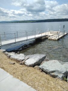
Kayak or Hike Canandaigua Lake Sunday August 18 from 4-6PM. ***BOATERS AND WALKERS WILL MEET AT DIFFERENT LOCATIONS***. Boaters will paddle south from Ontario County Beach Park (park and launch are free, no portaging necessary and there are bathrooms) on the east side of the lake passing Deep Run Park, the historic Thendara Restaurant and Boathouse which are now part of a Mcmansion housing development and, if time permits, past Crystal Beach Park where there are still some of the older quaint lakeside cottages.
Walkers will meet at the City Pier for a self-guided hike, by the boathouses, explore the marina area then head to Lakeshore Drive and turn right into Kershaw Park, following the trail along the lake. At Twisted Rail walkers will head back to the road, cross it and enter Lagoon Park where there is a figure-8 loop around several ponds; there are several board maps along the trail. Then strollers will retrace their steps back to the Pier for a total of 3 miles.
SOCIAL: Twisted Rail
DIRECTIONS FOR BOATERS: Ontario County Beach Park is on Rte 364 aka East Lake Road 2.7 miles south of the Rte 364 and Lakeshore Drive intersection on the right side of the road; if coming from the south it is just under a mile north of Deep Run Park and the CR 1 intersection and will be on the left side of the road.
DIRECTIONS FOR WALKERS: At intersection of Rte 332 aka South Main Street, Rte 5&20 and Lakeshore Drive turn right onto Lakeshore Drive, bearing right to enter the Pier area; if coming from the east turn left at the intersection.
The hike on Sunday, August 25 will be at the Gosnell Big Woods, a Town of Webster-owned nature preserve near Lake Ontario, including majestic old-growth forest, an open field, and a small meadow. Maintained by Friends of Webster Trails, a variety of trails offer beautiful views of meadows, wildflowers, and spectacular old-growth trees. Hikers may see butterflies, dragonflies, deer, and a variety of birds. Meet at 3:45 for a 4 PM hike start.
Naturalists will explore the Big Field and Meadow Trails, a total of 1.7 miles. They will start in the Big Field and Meadow Trails and continue onto Pellet Road, onto Ridge trail, join Big Woods trail, and head back to the car park on Big Field Trail, about 2.2 miles. If we want more we can divert into Whiting Woods Preserve off Pellet Road and make it 3 to 4 miles.
The picture below contains a link to the Gosnell Woods web page. If a click doesn’t take you straight there, press and hold the control key while clicking the image.
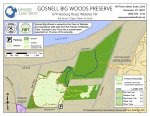
Parking: Meet at the Gosnell Big Woods Preserve Parking lot. 674 Vosburg Road, Webster. The car park is situated on the corner of Vosburg Road and Drumm Road.
From Rochester and points south; Take Route 490 or 390 to Route 590 North. At 3.7 miles north of the 490/590 intersection, take Route 104 East across Irondequoit Bay, then north on Bay Road (1.1 miles), right on Klem Road (.8 miles), left on Drumm Road (.6 miles), and enter the car park where the road turns left at the junction of Drumm and Vosburg Roads.
Social: After the hike we will adjourn to a lovely pub, specifics to be determined.

From Rochester and points North: Take 390 South to Routes 5 & 20, Proceed to Rt15A in Lima. Head South on Rt15A to Route 20A in Hemlock, Head East on 20A to East Lake Road in Honeoye. Proceed South on East Lake Road a short distance to County Road 33, (there are signs pointing the way from the junction of East Lake Road and County Road 33). Turn East on County Road 33, then Southeast on Pinewood Hill Road, which becomes becomes Gulick Road. After 5.6 miles the CNC entrance will be on the right.
From Springwater: Go North on Rt 15A to Route 20A in Hemlock, Head East on Rt 20A to East Lake Road in Honeoye. Proceed South on East Lake Road to County Road 33 (Signs point the way from the junction of East Lake Road and County Road 33). Turn East on County Road 33, then Southeast on Pinewood Hill Road. This becomes Gulick Road. After 5.6 miles the CNC entrance will be on the Right, about 1.5 miles past the Wesley Hill parking lot. OR, go to Naples and follow the directions below. They are both about 23 mile routes.
From Wayland, Naples, and points South: Follow NY 21 East from Wayland, thru N.Cohocton to Naples (11.4miles). Turn Left onto Clark Street (County Hwy36), heading North (Next to Middletown Tavern). Take first Right onto Gulick Road. Follow Gulick Road for 6.6 miles. CNC will be on the Left.
We will meet at the Erie Canal Boat Company at 7 Liftbridge Ln W, Fairport NY 14450 at 1:45 pm for a leisurely exploration of the Erie Canal. *Note: time change for this hike.
Hike – This hike starts and ends in Fairport on the paved canal path. From the parking lot turn left to follow the canal eastward to Palmira, a quiet section; or right toward the active Pittsford area Everyone should be mindful of the time and turn around at 3:00 pm to meet back up at 4:00pm.
Paddle or Bike – Bring your own or rent from the Erie Canal Boat Company: single kayaks $35 for 2 hrs, tandem kayaks for $45 per 2 hours, and bicycles for $30 for 2 hrs. If renting, preregistration for equipment rental is recommended. The Erie Canal Boat Company also offers adaptive kayaks and bikes for those with special needs.
The Bikers will head east, under the lift bridge and along the Canal as far as Waynesport Rd. At that point (about 5 miles), we will turn around and head back to the bridge to the old trolley path. We will cross the canal and ride the trolley path as far as our legs and time permit. This path goes by several neighborhoods in Perinton.
Social – We’ll enjoy a canal-side dish-to-pass social next to the Erie Canal Boat Company. They will allow us to use their mini-park with 4 or 5 picnic tables, along with a shaded area to sit under. Bring a dish to pass, your own beverage and some lawn chairs.
Directions to the Erie Canal Boat Company and boat launch: The Boat Company is located in a Fairport public parking lot on the west side of NY Rt 250 (AKA Fairport Nine Mile Point Rd, AKA Main St in Fairport). The entrance is 400 ft north of the bridge, directly opposite the RV&E Bike Shop on east side of Rt 250. Google Maps is accurate. Set to 7 Liftbridge Ln W, Fairport NY 14450. Phone 585-748-2628.
From Springwater, Naples and Honeoye: From Springwater take Wheaton Hill Rd to Canadice Rd, to Ontario County Rd 37. From Naples, take CR 36 (West Lake Rd) to Honeoye. From Honeoye, take US 20A west to CR 37. From the corner of CR 37 and US 20A, head north through W Bloomfield. At the light, continue straight onto NY 65. Outside W Bloomfield, continue straight onto CR 35. The road becomes CR 66 (W Bloomfield Rd) in Monroe County. You will cross NY-251 (Rush Mendon Rd) – continue straight for 4 miles. Turn right onto Thornell Rd. After 2.4 miles, turn right on NY-96. At the second light, turn left onto Kreag Rd. At the other end of Kreag Rd, turn right onto Ayrault Rd. At the first light, turn left onto Mosley Rd (NY-250). After you cross the canal and before you cross the railroad track, turn left into a parking lot behind the businesses. The meeting place is on the far end of the parking.
From Canandaigua: The simplest directions are: Take the Thruway to Exit 45 (I-490) Stay on I-490 to exit 26 (NY 31). Turn left onto NY 31 East. At the light, turn left onto Ayrault Rd. At the second light, turn left onto Mosley Rd (NY-250). After you cross the canal and before you cross the railroad track, turn left into a parking lot behind the businesses. The meeting place is on the far end of the parking.
 Hi everyone, This Sunday is our first maintenance hike of the year. As many of you know, as a group, we have been responsible for maintaining a section of the Bristol Hills Branch of the Finger Lakes Trail. Unfortunately, the section of the trail from Seman Rd to Mt Pleasant St in Naples has been closed and converted to a road walk, so now we are going to maintain the blue trail. On our first time, we are going to do some minimal maintenance while we explore the northern section of the blue trail. So, please bring a pair of clippers to trim back small branches and weed that are encroaching on the trail, and a walking stick that you can use to flick branches off the trail. Cloves may also be useful when the weed has thorns. And of course, bring water. Please arrive at 1:45 to allow time to plan a car pool. We expect the Tourists and Climbers will return to the cars by 4:30 after 3.5 miles of hiking.
We will not be cutting trees that cross the trail, although we may discuss future plans.
We also will not be pulling out roses and other invasives. And we will not be mowing the paths. These items will wait until spring.
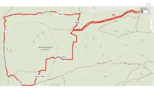
There are three options for this Sunday hike. We will select based on attendance. All hikers will meet at the Ontario St parking lot in the Village of Naples.
The Climbers and Tourists will car pool to the Parish Hill parking lot, which is also known as the Blue Trail parking lot, because the Blue Trail starts there. From there, we will follow the Blue Trail down to where it joins the yellow trail (click on the map to see a larger copy where you can follow the trails [or CTRL-click for a new tab]). We will follow the yellow trail (also blazed with blue) over a ridge and down to the Tom Noteware bridge across the top of Conklin Gully. There is a steep climb after the bridge, which will require care from all hikers. Unfortunately, this route is not recommended for hikers who prefer level ground. There is an backup route if needed. From the top of the climb, we will find enjoy views of Conklin Gully from the top. The Tourists will turn around at the lean-to/overlook and return to the cars at Parrish Hill Rd, again being careful with the steep areas. The Climbers will continue on the blue trail which follows a fire lane to join the orange trail. We will turn right and follow the orange trail down to the cars on Ontario St.
The Naturalists will start out on the orange trail across the Naples Creek. But at the register, they will turn left onto the Burgandy Trail along the creek. About half a mile down the trail, they will turn left onto a smaller trail and follow it back to the orange trail and turn left towards the cars. But before the bridge the will turn left and follow a trail south along the creek. This trail exits onto E Hill road. At that point, hikers can choose to turn around an walk back to the cars on the trail by the creek, or continue on the road up to S Main Street and walk on the sidewalk back to Ontario St and the the cars.
Following the hike, we will gather at a Bob and Ruth’s on the north end of Main St.
Directions:
From Springwater and Wayland, come south on Rt. 15 to the traffic light at Rt 21. Turn left on 21 and keep going all the way to Naples. Go through the downtown business area and turn right on Ontario Street, opposite the school. Go to the bottom of the hill and the parking lot is on the left.
From Dansville, follow Rt. 63 to Wayland where the road turns into Rt 21; continue on 21 all the way to Naples. Go through the downtown business area and turn right on Ontario Street, opposite the school. Go to the bottom of the hill and the parking lot is on the left.
From Naples, go to the school on Main Street (Rt. 21). Turn down Ontario Street opposite the school, go to the bottom of the hill and the parking lot is on the left.
From Canandaigua, head south on Rt 21 through Chesire and Woodville to Naples. Turn left on Ontario Street, opposite the school. Go to the bottom of the hill and the parking lot is on the left.
From Honeoye, head south on CR 36 (West Lake Rd) from 20A for 15 miles to Naples. Turn left onto Main St (Rt. 21). Turn down Ontario Street opposite the school, go to the bottom of the hill and the parking lot is on the left.
From Penn Yan, head west on North St and continue onto Rt 364W for 12 miles. In Middlesex, join NY 245 and continue for 9 miles. Turn left on NY 21 South (N Main St) into Naples. Turn left on Ontario Street, opposite the school. Go to the bottom of the hill and the parking lot is on the left.
We will visit the picturesque and historic Village of Hammondsport on Sunday September 29th, with two options. Those in favor of a vigorous woods walk will hike a combination of hillside trails southeast of the village including the June Bug Trail, while those interested in a more leisurely but scenic walk around the village will stay at lake level and enjoy a tour of the historic village and waterfront. We will meet at 1:45 and start together in separate directions at 2 PM from the Glenn Curtiss Museum, at 8415 Route 54, just southeast of the village. The two groups will reconvene at about 4PM for a dish-to-pass social at Champlin Beach, a mile to the north on Route 54, just north of the fire station. Come early if you’d like to explore the Museum, which features exhibits on Hammondsport and Keuka Lake history as well as on the career and exploits of Hammondsport’s own Glen Curtiss, early 20th century pioneer in the fields of bicycling, motorcycling and aviation. See https://glennhcurtissmuseum.org/ for more on the museum, which is open until 5. Watch for the airplane in the front yard.
Climbers and Tourists will cross Route 54 and head up the June Bug Trail to the hilltop ridge along the east side of Pleasant Valley – a significant climb, but well worth it. At the hilltop, we will join the a beautiful section of the Finger Lakes Trail going south along the ridge, returning the same way for a hike of about 3.5 miles. Poles will be helpful on the climb and descent.
Naturalists and History Buffs will drive from the meeting place to public parking next to the Post Office at 76 Pulteney Street in Hammondsport and begin the walking tour at the Pulteney Square Gazebo. The tour, led by local historian Terry Bretherton, will highlight the history of the village, its public square, and the very intact Victorian cottage neighborhoods over about an hour and a half. The walking tour group will then return to Champlin Beach to enjoy the social, along with swimming or wading opportunities.
Social – Please bring your favorite goodies for our dish-to-pass social at Champlin Beach, just north of the Route 54A intersection and the fire station on Route 94. Bring your own beverage and chairs/folding table in case the pavillons are reserved. A $5 contribution to our social fund is fine in lieu of the edibles.
Directions – From Springwater area, head south to Wayland and pick up 390 South to Bath. Take Exit 38E from 390 to Bath, and follow Route 54 north 8 .5 miles to the Glenn Curtiss Museum at #8415, on your left.
From Canandaigua and points north – take the most direct route to Penn Yan, then head south on Route 54 toward Hammondsport. Pass the intersection with Route 54A, and continue another .75 miles to the Glenn Curtiss Museum at #8415, on the right.
From Honeoye/Naples area – go the Naples and head south on Route 53 through Prattsburgh. Continue on Route 53 for 18 miles and make a left on Gardner Road, then right on County Road 13/Mitchellsville Road. At the end of Mitchellsville Road in Urbana, turn left onto Route 54. Go 1.8 miles to the Museum, on your left.
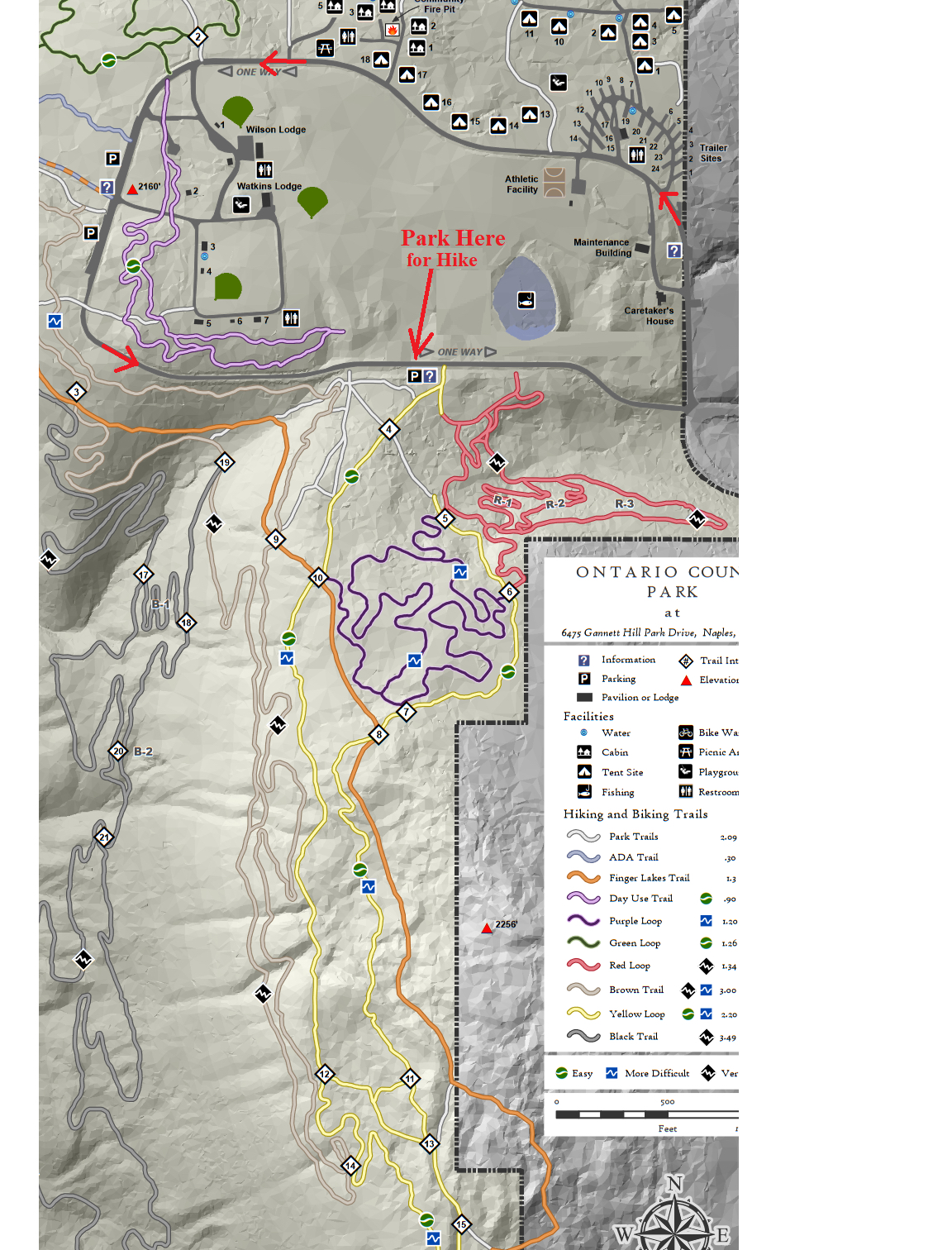
Social: Following our hike, we will drive back around the park loop to the Wilson Lodge parking area and gather for the social at an open pavilion near the Wilson Lodge rest rooms. Please bring a dish to pass or contribute $5. Bring your drink and maybe a chair.
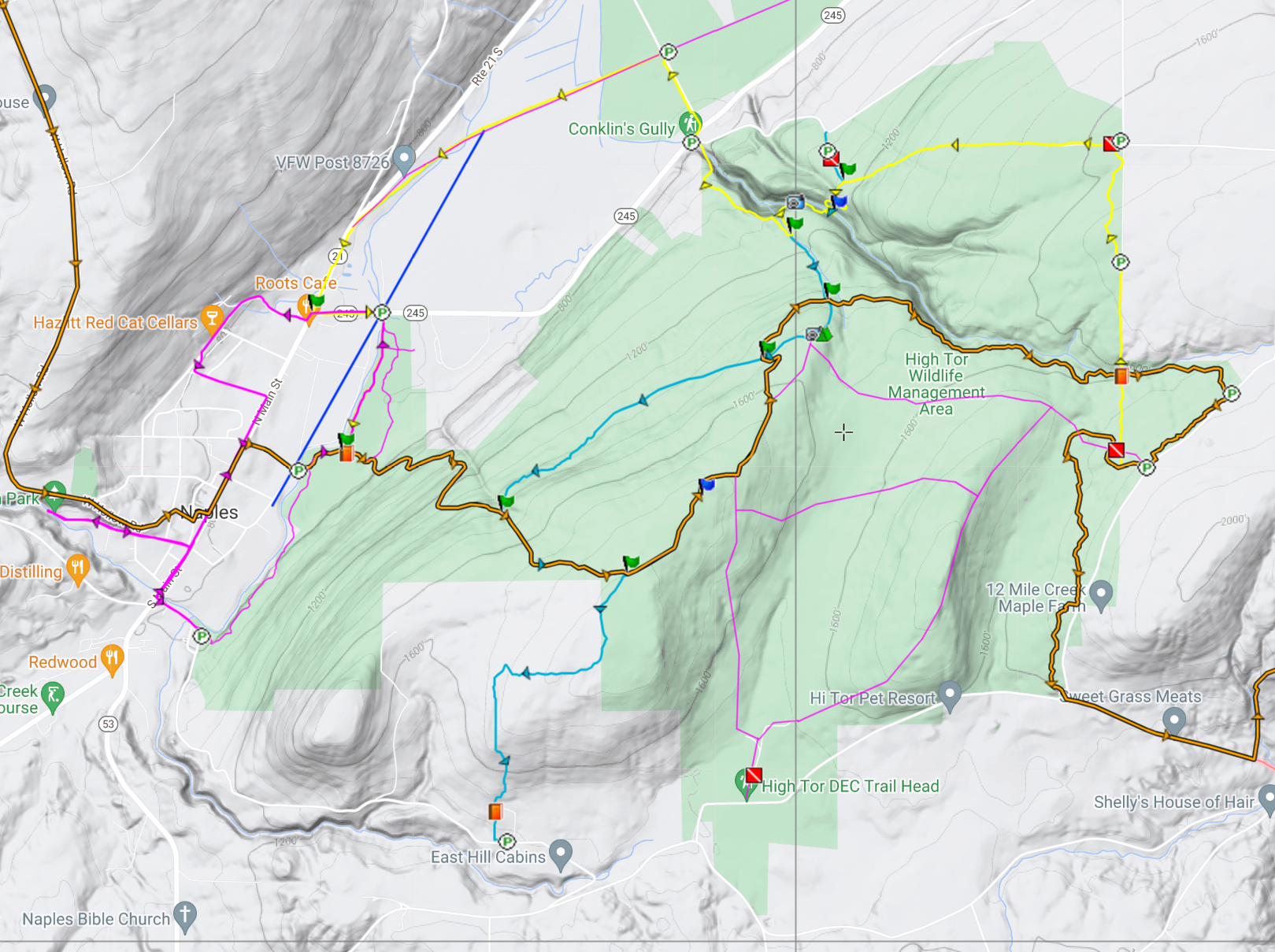
This Sunday’s hike at High Tor Wildlife Management Area in Naples will take us back to many of our previous hikes including:
- a hike by Springwater Parks and Trails at least one and a half decades ago
- a winter hike just before Covid hit
- and a follow-up to our maintenance hike on the Blue trail three weeks ago.
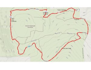
We will all meet at the DEC parking area on Basset Rd near the west end of the road (See the map to the right). Please arrive in time to start the hike at 2:00 PM. We will have two hikes based on distance. Hike leaders may adjust the hikes to accommodate our hikers and the weather. Please note: in the following hike descriptions, the term road refers to the maintenance road, which is more accurately called a wide trail.
All hikers will start on the same trail out of the parking area. The Naturalists will take the left route and follow the maintenance road up to the BHB orange trail. Turning left onto the BHB (orange blazes) they will quickly come to the pond and will explore the shore of that. Returning on the BHB to the maintenance road, the Naturalists will follow their own footsteps back to the cars.
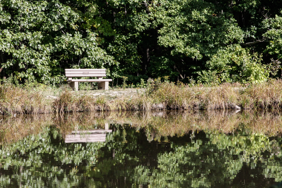
The Finger Lakes Trail from Naples to Parrish Gully. The Howard Beye memorial bench.
The Tourists will join the Naturalists up to the BHB orange intersection. The Tourists will continue straight on the maintenance road to the lean-to and overlook of Canandaigua Lake. Returning on the road, they will retrace their steps to the point where the BHB turns right. The tourists will continue straight (not on the BHB) south to the cars. They will likely meet up with the Naturalist on the final leg and will then return together to the cars.
The Climbers will also take the same route as the Naturalists. When they reach the BHB orange trail, the will turn left and continue around the pond. The Blue trail will break off to the right and the Climbers will follow that down to the Finger Lakes Community College property on East Hill Rd. Climbers are welcome to bring small clippers to do minor maintenance on the trail as we go. We will station a couple of cars at the final parking lot to ride back to the start point.
Following the hike, please join us for a social at Kelley’s home in Atlanta (NY). See directions below.
From Naples: Take NY 53 south from Naples for 1.1 miles. Turn left onto Italy Valley Rd (CR 21) for 2.1 miles. Turn left onto Basset Rd, when the main road takes a sharp right turn. Parking is on the left in 0.2 miles.
Additional directions are available here.
Directions To Kelly’s in Atlanta: Return to Naples by going right out of the parking area, then right onto Italy Valley Rd, then right onto NY-53 N. In 1.3 miles, turn left onto NY-21 S. In 4.5 miles, in N. Cohocton, turn right to stay on NY – 21. Take the next left onto University Ave. In 0.4 miles, Kelly’s home is the second house after the farmer’s field on the right.
Looking for brochure.or mailing list so I can receive it in the mail.
Nothing opens up for mailing list.
There’s all kinds of very bizarre ads and post for viagra and other drugs above on calender page.
Please let me know if there’s a brochure available