
Hikes led by Springwater Trails are generally held on Sunday afternoons and appear in this calendar in green.
| Sun | Mon | Tue | Wed | Thu | Fri | Sat |
|---|---|---|---|---|---|---|
| Lehigh Valley Trail Hike or Bike in Rush, NY 2:00 pm Lehigh Valley Trail Hike or Bike in Rush, NY @ Stevens-Connor Lehigh Valley Lodge Apr 6 @ 2:00 pm – 4:00 pm Come join us for a leisurely hike or bike along the Lehigh Valley Trail on Sunday April 6th! With its flat even surface, the trail is a hidden gem for walking, hiking, jogging, biking. It is a vital link in … Continue reading | ||||||
| Ontario County Park at Gannett Hill Hike-Naples 2:00 pm Ontario County Park at Gannett Hill Hike-Naples @ Lookout Parking area Apr 13 @ 2:00 pm – 4:00 pm  This is one of our group’s favorite hikes! Ontario County Park at Gannett Hill is one of the highest points in Ontario County and located in the scenic Bristol Hills. At an elevation of 2,256 feet above sea level, you’ll … Continue reading | ||||||
| No Hike-Easter Break 2:00 pm No Hike-Easter Break Apr 20 @ 2:00 pm – 4:00 pm No hike has been scheduled for this date due to the Easter Holiday. Enjoy the break, spend time with loved ones and eat chocolate bunnies. This will give you something to burn off next week  | ||||||
| Hike Rob’s Trail – Hemlock Lake side 2:00 pm Hike Rob’s Trail – Hemlock Lake side Apr 27 @ 2:00 pm – 4:00 pm Join us on Sunday April 27th to hike the west side of Rob’s Trail, the DEC/Nature Conservancy property in the northeast corner of Hemlock Lake! Options are to hike out and back to the south along the trail from the … Continue reading |
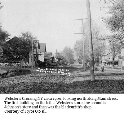 Our first Bicentennial Hike explored the Hamlet of Springwater back in April. This month we are going to explore Webster Crossing, the other hamlet in the Town of Springwater.
We will be meeting at Webster Crossing United Methodist Church, (Route 15, Webster Crossing Road, Springwater, NY 14560) at 4 p.m, The hike will start with a walking tour of Webster Crossing then break up into groups, depending on the distance comfortable for those who are attending. Suggested map routes for the Climbers, Tourists, and Naturalists will be provided.
We will be walking the Morris Road, Story Road, and the All Western Evergreen Tree Farms and other farm and homeowner’s properties depending on permission obtained. More details day of the hike.
The dish-to- pass social will be at the Webster Crossing Church where Gladys Weed, hamlet historian and retired postmaster, will have the history of the hamlet in photos and will be on hand to answer any questions.
Directions:
From Springwater and Wayland: Follow NY 15 north from Wayland to the flashing light in Springwater. Turn left to stay on NY 15. In 3.6 miles, the church is on the left.
From Rochester: Take I-390 South to Exit 9 – Lakeville. Turn left onto NY 15 south. Stay on NY 15 for 16.1 miles to Webster Crossing. The church is on the right.
Please note: For this hike, other routes recommended by your favorite routing tool are also available, and will get you to the church (42.669608, -77.635264) on time. Just enter the GPS coordinates and drive with confidence.
 This Sunday, Springwater Trails will be working with the Nature Conservancy to haul supplies for a footbridge across the gully and to help construct the remaining sections of Rob’s Trail extension. Please note the time change as we try to work with the Nature Conservancy schedule. Since we are planning this workday in real time, please check back here for updates. Please send John an email (vp@springwatertrails.org) if you are planning to come.
Rob’s Trail is one of the favorite hikes for Springwater Trails. The Central & Western New York Chapter of the Nature Conservancy built this trail in memory of Rob van der Stricht, their Board Chair who died in 2006. The trail from Rt 15A to Canadice Lake was opened in 2008.
In 2014, the Nature Conservancy announced plans to extend Rob’s Trail down to Hemlock Lake and the along the old road to the North Boat Launch. Based on the map published in the announcement, and on scouting done by Rick Osiecki, Springwater Trails led a hike from the west side of Hemlock Lake to the east side of Canadice last year, and this spring we hiked the partially completed extension from Rt 15A to the Hemlock North boat launch.
The work season for Rob’s Trail is just starting. There is a bridge to be built This Sunday, Springwater Trails will join the Nature Conservancy as they start the planned completion of this trail. Last Friday, we got a message requesting assistance with the work this spring, and decided to devote our trail maintenance Sunday to this trail. John took responsibility for planning and things have fallen into place. So please join us, and bring family members and friends, to help get this work off to a great start.
Details:
We will meet at the new trailhead/parking lot on the west side of 15A. This parking area is slightly north of the end of Old Bald Hill South and the original Rob’s Trail parking area. It connects directly to the Extension trail without crossing 15A. We will meet at 11:00AM. If you can’t make it at 11:00, please come as soon as possible and hike down the trail (west toward Hemlock Lake) to meet us. The upper part of the trail should be easy to follow. Bring work gloves and loppers. Be prepared for some digging in the dirt.
John will cater a social afterwards right at the parking area. Please contact him if you can help with the social – Springwater Trails will pay for the food.
Directions:
From Springwater: Go north on 15A for 6.0 miles. The parking area is on the left just after the north end of Old Bald Hill South.
From Hemlock: Go south on 15A for 5.1 miles. The parking area is on the right just before the north end of Old Bald Hill South.
Just when you thought you had seen the last of us, here we are again, leading our favorite hiking group, on a great level trail in our new home area.
We’re meeting at the west end of the Ontario Pathways trail, In the parking lot on Ontario St., and split into our usual 3 hiking groups. Then, each group will pool into 1 or 2 cars, to their starting point, and hike back to the meeting area. Climbers will go to CR 47, a distance of 5.8 miles. Tourists will go to Freshour Rd., distance 4.3 miles. Naturalists to CR 10, 1.5 miles.
As an added bonus, this time, there are loads of raspberry bushes alongside many parts of the OP trail, and there should be lots of ripe berries, begging to be picked. You can fill your berry baskets to take home, or simply enjoy a healthy trailside snack on your hike.
If you prefer to ride your bike today, the flat OP trail is a great place to do it. Ride east on the trail till 5 PM and head back. A round trip from the Ontario St. lot to Depot Rd. will be about 15 miles.
If you’d like to earn some freebies, doing your favorite activity, leave a little early and pick up an OP passport book at Wegman’s. You will encounter several rubbing spots on this trail. The Wegman family is rewarding you for your healthy lifestyle, so that you will live longer and buy more of their good food.
And, we mustn’t forget our post hike social. The New Covenant Baptist Church is located on the south side of CR 46, where the trail crosses this road, just east of CR 10. The members of this church are very friendly to hikers. There is a picnic table under a shelter (in case of rain). We will bring a folding table and you could bring one too, as well as chairs and, of course, your delicious dish to pass (start baking, Char) and drink.
Tim Wilbur, OP president, is being sent this hike description and hopefully, we will have the pleasure of Tim and some other OP members accepting our invitation of joining us for this one. This hike will be more fulfilling if you visit the good OP web site, www.ontariopathways.org, before the hike. You can print a map of the trail to take with you, which you should find quite helpful.
Directions from Springwater:
North on NY 15A
R on US 20A
At the T, where US 20A joins NY 64, turn L
Go R on Fisher Hill Rd.
L on CR 32
At 5 & 20, go straight. Becomes Bristol St.
L on Main St.
R on Ontario St, to Parking lot on L side.
If you want to go to Wegman’s before the hike:
Follow above directions. When you get to 5 & 20, turn R. Wegmans is on the R side.
From Wegman’s, R on 5 & 20
L on CR 10, just past Aldi on L
Go straight across first rotary, 3/4 around on second. This will put you west on CR 4, which becomes Ontario St. Go to parking lot on R
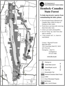
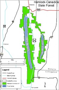
The NY DEC Map of the Hemlock Canadice State Forest. Click on the image to access a full brochure.
This hike will celebrate Hemlock Lake. On March 31, 1807, Seth Knowles and his family crossed the length of Hemlock Lake on the ice to take possession of a cabin he had built the previous year about a mile south of the southern end of the lake. They were the first known white residents in the future hamlet of Springwater.
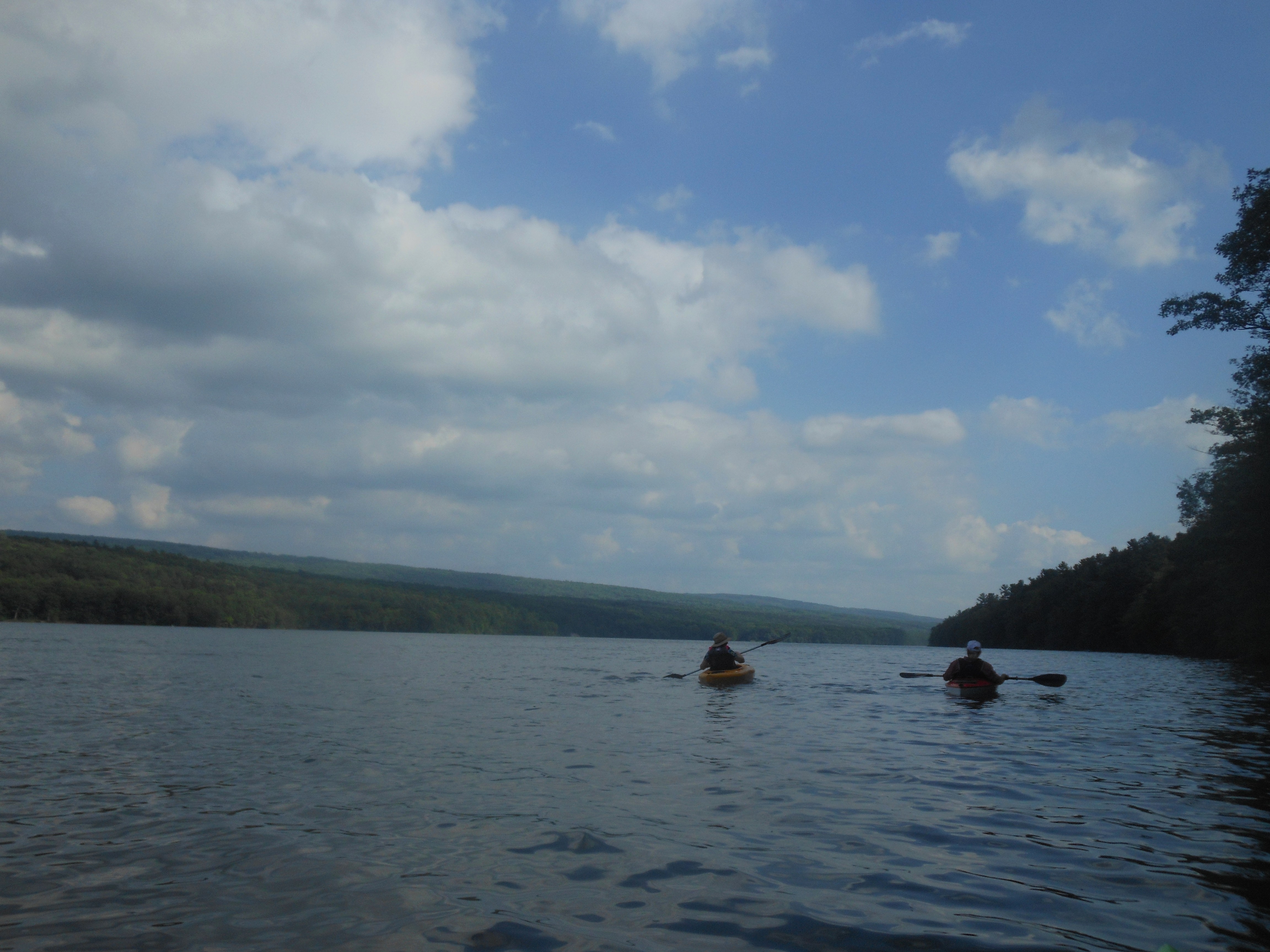
We will paddle the lake in the reverse direction from the South Boat Launch to the North Boat Launch (approximately 6 miles). Meanwhile, hikers can hike from the north boat launch, along the eastern shoreline to the bench and back.
Boaters will meet at the South Boat Launch with your canoe or kayak at 3PM to unload. At 3:30 PM the car shuttle will leave for the North Boat Launch where drivers will be given a ride back to the start. This should get us on the water by 4PM. We will have an on shore social about half way up the lake, so bring a sandwich and drink for yourself. Each paddler must have a PFD and is recommended to have a whistle and rope.
South boat launch area
Hikers will meet at the North Boat Launch at 4PM and will hike south on the old lake road for an hour. South of the bench, this trail becomes the new extension of Rob’s Trail and continues along the shore to about the halfway point of the lake. Hikers will stop at the bench or farther south for a mid-hike social, so bring a sandwich and drink. After the snack, hikers will return to the north boat launch.
All hikers and boaters should bring a sandwich and drink for themselves for a mid trip social.
Directions: Boaters will meet at the South Boat Launch at 3:00 PM. Hikers will meet at the North Boat Launch at 4:00 PM. Please click on the appropriate boat launch for driving directions.
To assist with our planning, please RSVP to hikes@springwatertrails.org if you plan to attend. Let us know if you will be hiking or boating, and whether you need to borrow a boat – there are a limited number of boats owned by regular hikers which can be made available on a first RSVP basis – if you do not RSVP, there will not be any extra boats.
Please note that the boating will be limited to experienced boaters who are able to handle their boat in case of an emergency. Please wait for another opportunity to learn to Kayak. All hikers interested in a easy hike on a beautiful finger lake are welcome to join the hikers at 4:00.
A combination of the expectation of another hot, sunny Sunday and relaxing last week on Hemlock lake, plus the frustration of trying to find a pleasant hike from Reynolds Gull to Wheaton Hill Trails, has caused a change in our Sunday Bicentennial Hike.
 This Sunday, we will take advantage of Canadice Lake, the smaller of the two undeveloped Finger Lakes north of the town of Springwater. Prior to the purchase of the land around these lakes by the City of Rochester, Canadice was known as the lake with cottages for the “locals”, while Hemlock catered more to the city folk. In celebration of the Springwater Bicentennial, the Hikers will take some extra time to explore some cottage foundations remaining on the west side of Canadice Lake.
We will all meet at the Canoe Launch near the south end of Canadice Lake. Boaters should arrive by 3:30 to allow time to unload boats and transport them to the lake. Following the hike and boating, we will have a Dish to Pass social at the Canoe Launch. Bring a dish to pass or make a donation to the Social Fund. Also bring your own beverage.
 Naturalists and Tourists will car pool to the south trail entrance and will follow the trail to the west side of the lake and up the west side. Checking the time, they will turn around to return to the cars and the canoe launch at 6:00. Climbers preferring a longer one way trip, will car pool to the north end of Canadice and arrange for a ride back with the Naturalists at the end of the hike. This trail is wide and fairly flat, allowing all hikers to enjoy the lake.
Boaters will launch from the Canoe Launch and will head North along the shoreline to the boat launch, about a mile and a half. From there, we will head across the lake to return south to the canoe launch for a 4 or 5 mile trip.
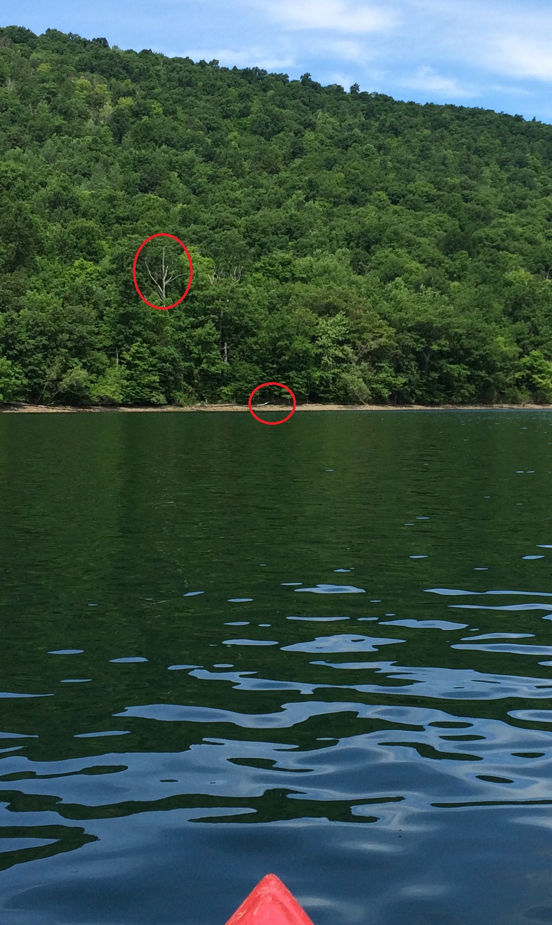
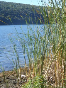
Suggested landing area for trading kayak paddlers.
A special suggestion: Boaters and Hikers may want to pair up, with one starting with the hikers and meeting the kayaker on the west side, where they can switch roles. With the low water level this weekend, landing is quite easy – the suggested location in the picture to the right is slightly north of the canoe launch. You can see the white tree above the landing area from the launch. The path from the hike route to the water is marked by yellow tape. More information will be available at the start of the hike.
Directions: Click on Directions for detailed directions, or on the starting points below for Google directions.
 From Springwater: Go North on 15A for 2.7 miles. Bear right on Old Bald Hill Rd S and then an immediate right on Johnson Hill Rd. Take the first left onto Canadice Lake Rd. The Canadice Canoe Launch is 1.8 miles north of Johnson Hill Rd.
From Honeoye: Take Co Rd 37 South from 20A, Turn right after 3.7mi to stay on Co Rd 37. Stay straight onto Burch Hill Rd. At the lake, turn left onto Canadice Lake Rd. The Canadice Canoe Launch is 2.1 miles south of Burch Hill Rd.
From Hemlock and Rochester: Take NY Rt 15A south from Rochester through Lima and Hemlock. Just past Hemlock, Rt 20A goes left. Continue straight on 15A for 3,2 miles after 20A. Turn left on Purcell Hill. At the end of Purcell Hill Rd, turn right onto Canadice Lake Rd on the east side of the lake. The Canoe Launch is 2.9 miles south.
Hemlock Lake is such a treasure for the residents of the Town of Springwater, providing opportunities for water and forest recreation year round in virtually undeveloped surroundings. I had wanted to enjoy a hike from Reynolds Gull through the Wheaton Hill trails to the entrance to the hamlet. Half of this route is on existing trails, with the rest being through the woods and across the gullies between. Unfortunately, Linda and I tried twice to find an enjoyable route, and each time returned exhausted and discouraged. The existing trails had not been mowed and were clogged with briars and roses. Each step in the woods was taken with care to avoid the fallen trees and to find a safe route across the gullies.
As a result, this hike is canceled and replaced by a hike and paddle at Canadice Lake, a natural followup to last week’s Hemlock adventure. See the description here or below.
This Sunday’s hike will transport us to the heights of Cleveland Hill in South Bristol. The view over the valley is well worth the climb. The trail is wooded, shady and in great shape, as we hope you are. For those of you who are familiar with the FLT, we will be hiking Map B1 between Access 2 and 3, also part of the trail to Access 1. Because the land is located in Camp Warren Cutler, BSA, No Dogs are Permitted.
Hikers will meet at 3:45, ready to hike at 4:00, at the trail head located on CR 33 (West Hollow Road). There is off road parking for a dozen vehicles.
Naturalists will cross West Hollow Road to head northeast on the orange blazed trail to head toward the beaver pond. The trail is mostly flat, with a couple of short pitches. The distance is .7 miles one way. After enjoying the serenity of the pond, naturalists will amble back to their starting point for a total of 1.4 miles. We will need a leader for this group. A map will be provided.
The Tourist group will carpool south on West Hollow, about 1 mile, to Access 3 on Clement Rd.. There is a spacious parking area off road. From there they will walk a short distance on Clement Rd to the orange blazed trail on the right side of the road. The trail passes an outhouse and a shelter before heading off into the woods. Following the orange trail, Tourists will climb a short series of gentle switchbacks for .9 miles before reaching the summit. There is a well defined clearing with two benches. Get out your binoculars to take in the view. After enjoying the scenery, the group will continue on the orange trail along a fairly flat grade, past a large area of forestry activity. At some point they should pass the Climbers coming up from the other side. Soon after the flat area begins the descent of about 1.5 miles, returning to the parking area on West Hollow Rd. Total distance 3 miles. A volunteer is needed to lead this group.
Climbers will head directly up the hill from the meeting place, following the orange blazes. The trail goes up, steeply in places, past several side trails to the summit of Cleveland Hill at 2 miles. The trail does flatten to follow the ridge at about 1.5 miles. Glimpses of the valley will tease hikers along the path, until they arrive at the spectacular overlook, complete with benches to rest the weary feet. The rest is all down hill for 1.1 miles to Clement Rd. Just before the road there is an outhouse and a very nice shelter. At this point climber can choose to trek back 3 miles to the parking area or do 1.5 miles of road walk, north on West Hollow Rd, to their vehicles.
After hike Social will be at Brew and Brats in Bristol Springs, just a few miles to the East over the hill. brewandbrats.com for directions and menu.
Directions: The parking area on CR 33 is 1.3 miles north of Porter Rd, 1.8 miles north of Clement Rd and 2.3 miles south of CR 34 (Egypt Valley Rd) on the west side of the road.
From Springwater: Head south on NY-15 for 5.0 mi. At the light in Wayland, turn left onto NY-21 N. Continue to follow NY-21 for 11.7 miles into Naples (turn left in N Cohocton, and again at the intersection with Rt 53). A half mile north of NY-53, at the Bristol Valley Playhouse, turn left onto Vine St, then an immediate right onto Race St, then the first left onto Cross St. After crossing Elizabeth St, this becomes CR 33 (W Hollow Rd). Continue for 5.6 miles. The parking area is on the left.
From Honeoye: Head east on US-20A. Turn right onto E Lake Rd. In 0.6 mi, turn left onto Pinewood Hill Rd. In 0.4 mi, this becomes CR-33 (Egypt Valley Rd). In 6.5 miles turn right onto W Hollow Road (staying on CR-33). The parking area is on the right in 2.3 miles.
Springwater Trails has been responsible for maintaining a section of the Bristol Hills Branch of the Finger Lakes Trail for over a year. We have two major projects for this summer:
- Repainting the orange blazes.
- A new bridge across the creek at the corner of the wildlife enclosure.
This week we will focus on the blazes. Many of the blazes are old and faded. And different sections have blazes that appear to be different colors. So, lets get out there and freshen up the blazes and make the trail look all spiffy.
We have paint, buckets and brushes, but we need some willing volunteers. Come join us at the park next to Bob & Ruth’s in Naples at 8:00. We will split into teams and will work from both ends of the trail.
Bring good hiking shoes and insect repellent, plus water to drink. If you have a weedwacker, bring that along and if we have enough volunteers, we will set up a team to mow the trail.
See you at 8:00 on Tuesday.
 On Sunday, Springwater Trails will be back to Wheaton Hill trails. This week we will focus on mowing the trails and do some work on the roses again.
Following our hard work, come for a picnic social at Schribner Rd. The social is hosted by Springwater Trails, Inc. We will provide hot dogs and burgers grilled on a charcoal grill and salads. You may want to bring something to drink.
The primary need is to mow the trails. We will have a small mower for the parking/picnic area, but the trails will be best done with weed wackers. If you aren’t mowing. We will have a small saw for logs across the trail. There is also one large leaner across the trail which we will not try to remove.
And, clippers for the roses will be useful on all of the trails. You may find some that need trimming before they get out into the trail, or you may choose to attack a large bush at the side of the trail. Clippers and gloves are very important for this work – if you always keep the bush away from your arms and legs, you can avoid scratches, and more importantly, poison ivy which seems to like the roses. Plan to wash your cloves and any other clothes that may have touched the poison ivy.
Directions: Wheaton Hill is the first right turn north of the intersection of Rt 15 and Rt 15A in Springwater (0.9 mile north of the intersection). The trail head is 0.5 miles up Wheaton Hill just before the road turns straight east and heads up the main hill. More details are on the directions page.
What to bring:
- Bring a weed wacker if you can. We could have one on each of the four trails.
- Gloves and clippers – hand clippers or long handled loppers if you want to attack a large rose bush.
- Small bow saw.
- Plastic grocery bag in case you find any litter.
- Water to keep hydrated.
Looking for brochure.or mailing list so I can receive it in the mail.
Nothing opens up for mailing list.
There’s all kinds of very bizarre ads and post for viagra and other drugs above on calender page.
Please let me know if there’s a brochure available