
Hikes led by Springwater Trails are generally held on Sunday afternoons and appear in this calendar in green.

Springwater Trails hikers have opportunity to hike with other hikers at the Finger Lakes Trail Conference (FLTC) 2015 annual Howard Beye hike to be held Saturday, January 10th 2015, 10:00AM start time. Finish time best guess is perhaps around 1:00PM or so. (Participation in the Howard Beye Winter Hike by Springwater Trails has become a tradition, an auxiliary Springwater Trails event.) This year the hike is an approximately 6 mile hike on the Letchworth Branch Trail of the Finger Lakes Trail; between access point C at Hogsback Overlook and Access point E on River Rd; located in the north end of Letchworth State Park on the eastern side. Meet at access point C for the hike start. More details by “clicking on” the hyperlink provided above or by viewing the fltconference.org website.
Trail terrain in this area is mixed rolling hills and relatively flat with some small creek crossings, NO big hills! Springwater Trails hiking group hiked some of this trail route previously, most recently on our 6/1/2014 hike.
This hike is being held on the eastern side of Letchworth State Park; there is no park admittance fee on the eastern side of the park.
Hogsback Overlook is on Visitor Center Road a short distance south of the Mt Morris Dam Visitor’s Center. Visitor Center Rd is accessed via NYS Rt 408 south of the Village of Mount Morris.
There are seven separate scheduled hikes in recognition of North Country National Scenic Trail (NCNST) Day for 2015 (Saturday, September 26th, 2015). The locales are spread throughout NYS and in North Dakota, Michigan and Pennsylvania if you are traveling.
There are three hikes accessible from Springwater this year
- Hike #1 FLTC Map M1, Allegany State Park at 8:30am – Hike from New York to Pennsylvania!
- Hike #6 Three Preserve Hike – Enfield, NY in Tompkins County at 10:00am – Lead by Roger Hopkins from the Cayuga Trails Club
- Hike #7 FLT Map M4, Boyce Hill State Forest, Franklinville, NY at 10am – Get directions here.
Some unique hike opportunities exist if you wish to get in some hiking beyond a weekly S/T hike.
Details can be found on the North Country website and on the Finger Lakes Trail Conference website.
Please check and confirm start times and locations. The time listing in this Springwater Trails listing is used as a foothold approximation only! So, be sure to check the posting on the FLTC website for more exacting details, and further hike options.
Hike Leader – Cate Concannon, catrina616@gmail.com
Hike Description – Map B3, Access 18 to Map 12, Access 2.
This hike will start with a steep uphill at Access 18 off Mitchellsville Road on the Bristol Hills Trail. We will follow the BHT through the forest, past Lake David and through gullies for a total of 3.6 miles, then cross over to the mail FLT with a short road walk on Harrisburg Hollow Road. We should have some nice views of the area and finish the hike on 2.1 miles of the main FLT trail. A hike encompassing two maps and two different trails – how fun! Perhaps someone will know if this is the first time this has been done on the Named Hike series.
Car Pooling: Springwater Trails will organize a car pool from the parking area behind the Wayland Fire House. Be at the parking are at 9:15 – we will leave promptly at 9:25!
Meeting time – 10 am, with a departure time of 10:10. We’ll need to place cars for the car shuttle.
Meeting place – We will meet at the Hickory Hill Campground (click for map and directions) . From there we will drop cars at our end point and proceed to our starting point, Access 18 on Route 13. From exit 38 off I-86 (Route 17), follow signs to Route 54. After following Rt 54 through town including a 90 degree left turn, Route 13/Mitchellsville Road will branch off to the left. Prominent signs for the campground, which will be on your left off Rt 13 just north of Bath.
Notes – Please dress for the weather, but as a general rule of thumb, dress in layers and bring extra clothes. Waterproof jacket & pants will most likely come in handy, plus hat and gloves. Pack a lunch that can be eaten quickly on the trail, plus lots of water.Be prepared for steep ascents and descents! E-mail hike leader with your interest in joining the hike – carpooling is encouraged and she will help to organize.
Updates: Check for updates at the FLT website.
 The Finger Lakes Trail across upstate NY was started in 1962, and for nearly 25 of those years, Howard Beye was THE major volunteer for the organization that tends it. He was a deeply involved trail chair, keeping track of map updates, organizing and training those who adopt portions of our over 900-mile trail system, tracking volunteer hours for every one of them during an annual “census,” arranging Challenge Cost Share projects, and organizing every one of our three to four special work-week projects, the annual “Alley Cats,” and handling the majority of correspondence with the state agencies who host many miles of our trail.
2017 HOWARD BEYE WINTER HIKE
We will hike to Huckleberry Bog on the Bristol Hills Trail and follow the Bog Nature Trail Loop. This is an upland bog located on a plateau west of Keuka Lake in Urbana State Forest, Steuben County. Two routes will be offered, one approaching from the north and one from the south. Both hikes are loop hikes and both ~4.5 miles.
a) Northern Approach. The trail climbs steadily through a hemlock and oak woods to the top of the plateau, going by the Evangeline Shelter and entering Urbana State Forest before reaching the Bog Nature Trail Loop.
b) Southern Approach. The hike starts at a higher elevation and directly enters Urbana State Forest. It will be a somewhat slower hike. Hikers will follow the Bog Nature Trail Loop and along the way stop at the observation deck to see how the bog looks in mid-winter.
A Bog Nature Trail Guide can be downloaded from the FLTC website.
The Huckleberry Bog Nature Trail is Hike #6 in the FLT Passport book for the Central Portion. Bring your book and a pencil if you would like to take a rubbing.
Bring water and a lunch that can be eaten on the trail. Snowshoes may be needed if the snow is deep.
Meeting time9:30am. Car pools will leave for the hike at 9:45am. LocationMeet at Heron Hill Winery, 9301 County Route 76, Hammondsport, NY 14840 in the upper parking lot. The parking at the trailhead is very limited, so we will leave the majority of the cars at Heron Hill. The Heron Hill winery will be open from 10-5. There will not be restrooms at the winery available for us to use prior to the hike. Directions to Meeting LocationFrom Springwater: Head south of NY-15 through Wayland. Turn left onto I-390 S. In 15.9 miles, merge onto I-86 E. Take Exit 38 Bath. Turn left onto Washington St (NY 54). In 1.2 miles turn left onto Liberty St to stay on NY 54. Follow NY 54 for 6.7 miles into Hammondsport. From the Village of Hammondsport turn left on Main St/NY-54A. At the T, turn right onto Pulteney St to stay on NY-54A and go .33 miles. Turn slight left onto Pulteney St/ CR 76 and go 2.99 miles. Follow signs and turn left onto the Hill Winery driveway. Park in the upper parking lot. Enjoy the view of Keuka Lake. |
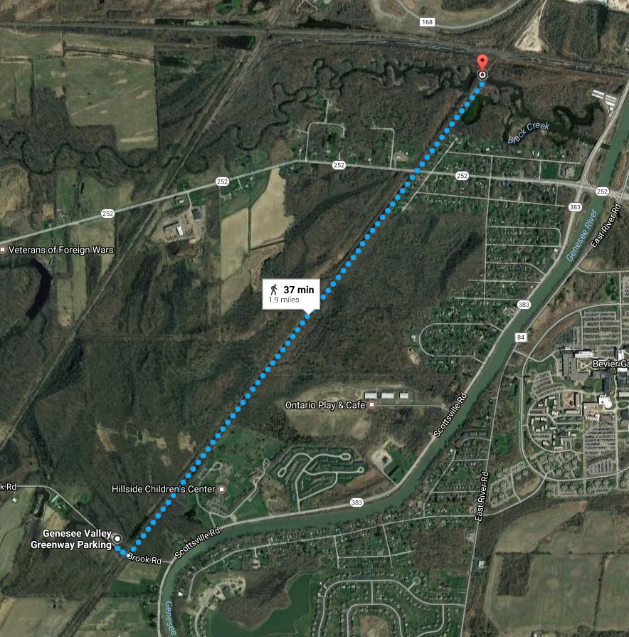 Today’s hike is an easy, flat trail with cinder surface, crossing an historic double-arched Genesee Valley Canal (GVC) culvert.
Meet at the Brook Rd Genesee Valley Greenway (GVG) Parking area. Total distance out and back is 3.7 miles.
For more information, check the Friends of the Genesee Valley Greenway (FOGVG) website, their Passport page, and the complete 2017 GVG Passport Series.
– – – Additionally, the Genesee Valley Greenway State Park (GVGSP) Facebook page usually lists the upcoming GVGSP events, and the FOGVG Facebook page also lists numerous GVG events in our area albeit a greater proportion of events listed on this page may at times be in the “Southern Tier” portion of the GVG as planned by a group of hikers known as the Southern Tier Greenway Hiking Group (STGH or STGHG) who welcomes all to hike with them.
– – – We also have a short history of the Greenway.
(subnote: The historic double-arched Genesee Valley Canal culvert (aqueduct) is best viewed for picturesque value from points other than on the GVG itself. As attested to by on-site GVG signage, the culvert/aqueduct, later turned viaduct for the railroad and subsequently the GVG, conducted the GVC over Black Creek. A great photographic vantage point is offered while on Black Creek in a kayak/canoe/boat. At low water levels you may be able to paddle Black Creek under the GVG to view both sides of the historic culvert , but at high water levels … well, not so.)
So, you’ve been itching to get on your bike this Spring with impetus of a group bike outing of some kind. Well, here is an opportunity to do just that … on the Genesee Valley Greenway (GVG) from Avon to York Landing (round trip) on Saturday May 20th, 2017 at 10:00AM. Approximately a 17 mile round trip easy paced bike ride, and all trail mileage covered is in the nw corner of Livingston County. Meet location is at the Erie-Attica Trail (EAT) trailhead in Avon, accessed by Farmers Road off Rts 5&20 just east of the Genesee River.
– – – A digression – – Speaking of itching, this Hike Planner has had impetus to utilize the section of the GVG shortly north of Fowlerville Rd (and south of US Rt 20), said section has a short duration of trail topped with thick stone dust (mostly fine stone sans dust), for a ST hike since early Spring 2016 just following reconstruction of said section of trail which had been necessitated as result of a huge washout area. The thick stone dust topper (as determined during a potential preview hike in April 2016), provided wonderful cushioning upon a hikers joints, albeit bike/stroller/wheelchair wheels found much friction/consternation due to sinking in the freshly laid thick topper surface.
Due to complaints of wheeled trail users, later in 2016 the topper surface was rolled by a heavy duty roller to make for some compaction factor, and the surface is said now to be kinder to the aforementioned narrow wheeled vehicles (and probably offers less of an exuberant opportunity for a hiker’s joints). If there is a lesson here, perhaps it is that not all opportunities are lasting, some have but a small window of opportunity. Still, a future ST hike planned to utilize this section of the GVG may offer multiple unique opportunities including this now somewhat tamed section of thick stone dust topper.
Anyway, you’ll get to see this short section and so much more of the GVG via your bike on this traverse much more quickly than while on a hike. – – –
(A further digression, …for the curious, … utilization of the aforementioned section of trail south of US Rt 20 was in consideration for the 4/24/2016 ST hike, but ultimately was scrapped from the fledgling Hike Plan due to what would have been a controverted driving route to reach the GVG trailhead parking lot on US Rt 20, all thanks to road reconstruction on US Rt 20 just east of the GVG trailhead. -Now you know – substantially trials and tribulations that weighed in nixing this unique section of trail south of US Rt 20 for the 4/24 ST hike, … instead all hiking groups headed north from Avon.) – – – End of digressions. – – –
GETTING THERE:
From just inside Avon’s western town limits, to reach the Erie-Attica Trail parking lot & trailhead follow Farmers Rd to the end where you’ll find both the parking lot & the trailhead. – – – Seem familiar? Well, ST has in the past (10/18/2015 hike) held a hike utilizing exactly this trailhead and parking lot, as well as parts of the connecting GVG, so yes, it may seem familiar. And an April 24th 2016 ST hike also utilized the GVG in this area.
Detailed Directions From Springwater: Take Rt 15A North. In Lima, turn left on US Rt 20 (concurrent NY Rt 5, thus known as Rts 5&20). Follow Rts 5&20 for 7.6 miles (you will cross over I-390, pass through the hamlet of East Avon and the Village of Avon. After the traffic circle in the village, continue on Rts 5&20 for 0.8mi and turn right on Farmers Rd. The parking area is on the right, just after you pass under the flyover for the former RR truss bridge (now the Erie-Attica Trail truss bridge).
Further Event Details for this May 20th biking event are listed on the FOGVG Facebook page.
GVG Passport Booklet: This bike ride will cover a stretch of trail where you’ll be able to avail yourself of making a rubbing in the Wegman’s Passport to Family Wellness – GVG passport booklet. For those unfamiliar – – – Wegmans – “Passport to Family Wellness Program” series booklet for the Genesee Valley Greenway is a passport compilation of 14 separate hikes on the GVG, each hike route having a “rubbing post” for trail users to produce a “rubbing” in their passport booklet with purpose of documenting that a trail user has completed the respective hike. Passport booklets filled-in with rubbings can be turned in at a Wegmans retail store for redemption of coupons for Wegmans brand products and entry for a prize drawing. So, remember to bring your GVG passport booklet on this bike ride.
(Event post initially published on 5/7/2017, updated 5/17/2017.)
Genesee Valley Greenway State Park (GVGSP) Passport Hike Series–Brook Road to Morgan Road–Wegmans Hike #3
Saturday, June 10, 2017 at 10:00 AM
Brookdale Preserve, on Brook Road, Scottsville, NY
The GPS Coordinates: N43 04.577 W77 42.550
Meet at the Brook Rd Genesee Valley Greenway (GVG) Parking area.
The hike will be going southward from the Brook Road parking lot along the eastern edge of Brookdale Preserve. We will see remnants of the Genesee Valley Canal and the well preserved Lock #2.
The hike leader is Elijah Kruger from the educational staff of Letchworth State Park. The hike distance is 4.3 miles round trip. The Genesee Valley Greenway State Park is hosting this hike. There is no charge to attend this hike. Therefore, please consider joining us.
For more information, check the Friends of the Genesee Valley Greenway (FOGVG) website, their Passport page, and the complete 2017 GVG Passport Series.
– – – Additionally, the Genesee Valley Greenway State Park (GVGSP) Facebook page usually lists the upcoming GVGSP events, and the FOGVG Facebook page also lists numerous GVG events in our area albeit a greater proportion of events listed on this page may at times be in the “Southern Tier” portion of the GVG as planned by a group of hikers known as the Southern Tier Greenway Hiking Group (STGH or STGHG) who welcomes all to hike with them.
– – – We also have a short history of the Greenway.
Genesee Valley Greenway (GVG) hike on Saturday, 8/12/2017. Series Hike #5—Fowlerville Road going north.
Historic Interpretive Hike Series (Wegmans Hike #5): Fowlerville Rd going north Saturday, August 12, 2017 10:00 AM GVG Parking Area Fowlerville Road, Town of York, NY. Meet at the parking area on the south side of Fowlerville Road (GPS: N42 53.505 W77 49.419) Starting at GVG mile 21, hike to just past mile 20 on easy, flat trail with a mixed surface. (2.7 miles total)
The guide will provide history of the Town of York and also point out historic canal and railroad features, including stone remaining from the Genesee Valley Canal Lock #5, and interesting natural features along the way. This hike is one of 14 hikes in the Wegmans Passport to Wellness Program. Completion of hikes in this series makes the trail user eligible for Wegmans grocery coupons or a NYS Parks Empire Passport. Passports will be available at the time of the hike and there will be an opportunity to complete the rubbing for this hike. Questions: fogvg@frontier.com or (585) 493-3600
Please note, that this section of trail contains a mixed surface, … one segment is surfaced with a thick layer of stone dust / finely crushed stone chips and is unique in that it affords a degree of shock absorption for hikers with aging and/or ailing joints. A unique trail surface indeed. This unique surface is owing to a major trail washout and subsequent trail rebuild that was completed about 1 1/2 years ago, and this unique surface was put in place as completion of the trail rebuild. – – Spring 2016 found a delightful shock absorbing surface for hikers on this reopened segment, and though the surface has since been compacted it likely still affords a uniqueness.
The Genesee Valley Greenway State Park is hosting this hike. There is no charge to attend this hike. Therefore, please consider joining us.
For more information, check the Friends of the Genesee Valley Greenway (FOGVG) website, their Passport page, and the complete 2017 GVG Passport Series.
– – – Additionally, the Genesee Valley Greenway State Park (GVGSP) Facebook page usually lists the upcoming GVGSP events, and the FOGVG Facebook page also lists numerous GVG events in our area albeit a greater proportion of events listed on this page may at times be in the “Southern Tier” portion of the GVG as planned by a group of hikers known as the Southern Tier Greenway Hiking Group (STGH or STGHG) who welcomes all to hike with them.
– – – We also have a short history of the Greenway.
Genesee Valley Greenway (GVG) hike on Saturday, 9/9/2017. Series Hike #6 (modified)—Fowlerville Road going south.
Historic Interpretive Hike Series (Wegmans Hike #6, please note this hike is modified): Fowlerville Rd going south Saturday, September 9th, 2017 10:00 AM GVG Parking Area Fowlerville Road, Town of York, NY. Meet at the parking area on the south side of Fowlerville Road (GPS: N42 53.505 W77 49.419)
Starting at GVG mile 21, hike southbound to the major trail washout and turnaround and hike back to the parking area. **Special note on modification – This hike usually starts at York Landing and travels north but, due to a serious trail wash out just north of York Landing in June, we will be starting at Fowlerville Road (~GVG mile 21) and hiking south to the wash out, about 1.8 miles. This hike is on easy, flat trail with a mixed surface. (3.6 miles total)
The guide will provide history of the Town of York and also point out historic canal and railroad features, and also note interesting natural features along the way. This hike is one of 14 hikes in the Wegmans Passport to Wellness Program. Completion of hikes in this series makes the trail user eligible for Wegmans grocery coupons or a NYS Parks Empire Passport. Passports will be available at the time of the hike and there will be an opportunity to complete the rubbing for this hike. Questions: fogvg@frontier.com or (585) 493-3600
The Genesee Valley Greenway State Park is hosting this hike. There is no charge to attend this hike. Therefore, please consider joining us.
For more information, check the Friends of the Genesee Valley Greenway (FOGVG) website, their Passport page, and the complete 2017 GVG Passport Series.
– – – Additionally, the Genesee Valley Greenway State Park (GVGSP) Facebook page usually lists the upcoming GVGSP events, and the FOGVG Facebook page also lists numerous GVG events in our area albeit a greater proportion of events listed on this page may at times be in the “Southern Tier” portion of the GVG as planned by a group of hikers known as the Southern Tier Greenway Hiking Group (STGH or STGHG) who welcomes all to hike with them.
– – – We also have a short history of the Greenway.
Looking for brochure.or mailing list so I can receive it in the mail.
Nothing opens up for mailing list.
There’s all kinds of very bizarre ads and post for viagra and other drugs above on calender page.
Please let me know if there’s a brochure available