
Hikes led by Springwater Trails are generally held on Sunday afternoons and appear in this calendar in green.

Springwater Trails hikers have opportunity to hike with other hikers at the Finger Lakes Trail Conference (FLTC) 2015 annual Howard Beye hike to be held Saturday, January 10th 2015, 10:00AM start time. Finish time best guess is perhaps around 1:00PM or so. (Participation in the Howard Beye Winter Hike by Springwater Trails has become a tradition, an auxiliary Springwater Trails event.) This year the hike is an approximately 6 mile hike on the Letchworth Branch Trail of the Finger Lakes Trail; between access point C at Hogsback Overlook and Access point E on River Rd; located in the north end of Letchworth State Park on the eastern side. Meet at access point C for the hike start. More details by “clicking on” the hyperlink provided above or by viewing the fltconference.org website.
Trail terrain in this area is mixed rolling hills and relatively flat with some small creek crossings, NO big hills! Springwater Trails hiking group hiked some of this trail route previously, most recently on our 6/1/2014 hike.
This hike is being held on the eastern side of Letchworth State Park; there is no park admittance fee on the eastern side of the park.
Hogsback Overlook is on Visitor Center Road a short distance south of the Mt Morris Dam Visitor’s Center. Visitor Center Rd is accessed via NYS Rt 408 south of the Village of Mount Morris.
There are seven separate scheduled hikes in recognition of North Country National Scenic Trail (NCNST) Day for 2015 (Saturday, September 26th, 2015). The locales are spread throughout NYS and in North Dakota, Michigan and Pennsylvania if you are traveling.
There are three hikes accessible from Springwater this year
- Hike #1 FLTC Map M1, Allegany State Park at 8:30am – Hike from New York to Pennsylvania!
- Hike #6 Three Preserve Hike – Enfield, NY in Tompkins County at 10:00am – Lead by Roger Hopkins from the Cayuga Trails Club
- Hike #7 FLT Map M4, Boyce Hill State Forest, Franklinville, NY at 10am – Get directions here.
Some unique hike opportunities exist if you wish to get in some hiking beyond a weekly S/T hike.
Details can be found on the North Country website and on the Finger Lakes Trail Conference website.
Please check and confirm start times and locations. The time listing in this Springwater Trails listing is used as a foothold approximation only! So, be sure to check the posting on the FLTC website for more exacting details, and further hike options.
Hike Leader – Cate Concannon, catrina616@gmail.com
Hike Description – Map B3, Access 18 to Map 12, Access 2.
This hike will start with a steep uphill at Access 18 off Mitchellsville Road on the Bristol Hills Trail. We will follow the BHT through the forest, past Lake David and through gullies for a total of 3.6 miles, then cross over to the mail FLT with a short road walk on Harrisburg Hollow Road. We should have some nice views of the area and finish the hike on 2.1 miles of the main FLT trail. A hike encompassing two maps and two different trails – how fun! Perhaps someone will know if this is the first time this has been done on the Named Hike series.
Car Pooling: Springwater Trails will organize a car pool from the parking area behind the Wayland Fire House. Be at the parking are at 9:15 – we will leave promptly at 9:25!
Meeting time – 10 am, with a departure time of 10:10. We’ll need to place cars for the car shuttle.
Meeting place – We will meet at the Hickory Hill Campground (click for map and directions) . From there we will drop cars at our end point and proceed to our starting point, Access 18 on Route 13. From exit 38 off I-86 (Route 17), follow signs to Route 54. After following Rt 54 through town including a 90 degree left turn, Route 13/Mitchellsville Road will branch off to the left. Prominent signs for the campground, which will be on your left off Rt 13 just north of Bath.
Notes – Please dress for the weather, but as a general rule of thumb, dress in layers and bring extra clothes. Waterproof jacket & pants will most likely come in handy, plus hat and gloves. Pack a lunch that can be eaten quickly on the trail, plus lots of water.Be prepared for steep ascents and descents! E-mail hike leader with your interest in joining the hike – carpooling is encouraged and she will help to organize.
Updates: Check for updates at the FLT website.

Overlook (Honeoye Lake Harriet Hollister Spencer (1887-1962) was born in Rochester, NY. She was a Charter Member of the Rochester Garden Club and was known as a rose expert. She designed the Garden of Fragrance at the Rochester Museum and Science Center and contributed roses from her own garden. In 1963, her family donated, at her request, 679 acres of land to New York State for the Harriet Hollister Spencer State Recreation Area.
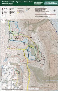 At 2000 feet, this park generally receives and keeps a good covering of snow each winter, and is one of four parks groomed for cross country skiing by the Rochester XC Ski Foundation.
Following the hike, an optional social will be at Sammy’s in Springwater.
The Naturalists will follow Bear Cub Run from the parking area to the snow shoe trail S6 just down the hill from the road. They will cross the overlook, cross Racoon Run, and then will make a short steep hike up to the loop at the end of the road. Then the Pines and Bypass trails will return to the parking area. Depending on the time, a hike to the north around the Big Oak trail may be possible.
The Tourists will similarly follow Bear Cub to the snow shoe trail, but will turn left on Racoon Run. Next is a left for a quick Fox Run loop, back to Racoon Run. Take the next left down to Lower Sidewinder, and follow that loop in a clockwise direction. At the information sign, we will stay to the left to follow a snowshoe trail across the snowmobile trail out toward Canadice Hill Rd and back. From their, heading north on Blue Spruce Run, Whiteface, and Cannonball, will bring us back to the road and the parking area.
The Climbers will follow Bear Cub Run to the road, and then will cross the road to follow the bypass and Chalet trails to the snowmobile trail. From there, we will follow the snowmobile trail south for about 2 miles, crossing into the town of Springwater, where we will turn west to reach the corner of Wetmore and Tibbels Road (which used to be named Springwater Canadice Town Line Road). Total length 3.3 miles, if we do not get lost.
Directions:
Check our standard directions to the HHS parking lot. Climbers coming from Springwater should meet at the corner of Wetmore and Tibbels Rd, to carpool to the parking lot. That way, we will have cars at the end of the hike.
From Springwater: (Climbers only): Take Route 15A north out of Springwater for one mile and turn right on Wheaton Hill Road. Continue to the top of the hill. At the T, turn left on Wetmore Rd. Stay on Wetmore, to the first road on the left (Tibbels Rd which used to be called Town Line Rd). You will see a welcome sign for Canadice. We will park on the right side, and car pool up to the parking lot.
At 10:00 a.m. on New Years Day, you and your family and friends are invited to meet at at the Genesee Valley Greenway State Park’s Brook Road parking lot in the town of Chili. A walk one mile south will take us to the best preserved c.1840 Genesee Valley Canal lock on the entire trail. A walk two miles north will take us to the double-arch Genesee Valley Canal culvert which carried Black Creek under the old canal, a pretty special artifact built more than 170 years ago!
Directions:
Getting to Brook Road: Brook Rd parking lot, Chili, NY (Brook Rd is located off Scottsville Rd about 2 miles south of the intersection of Jefferson and Scottsville Roads. Brook Rd is a west turn only and the GVG parking area is only a few hundred feet down the road just past the Greenway crossing.
For those Springwater Trails hikers who revel in hiking Harriet Hollister Spencer State Recreation Area (HHSSRA aka HHSMRA where M is Memorial) with snow, well the ST hike on Sunday 1/22/2017 did not support that as the ground was devoid of the white stuff. But then it snowed on Tuesday 1/24/2017 and is predicted to do so again before Saturday 1/28/2017. Which leads me to citing a second chance for participation in a group hike where perhaps there may be snow, albeit this one on Saturday 1/28/2017 a mere 6 days since ST Sunday 1/22/2017 hike.
This hike is a scheduled hike on the Genesee Valley Hiking Club (GVHC aka GVHG where G is Group) hike schedule, and Ryan B. is the Hike Leader (& Planner). Some ST hikers are acquainted with Ryan as result of his hike leads and shared hiking enthusiasm.
The salient info for this hike is below in quotes, from the GVHC website. Hike start time is 10:00AM, likely most folks from ST will not benefit from use of the 9AM carpool as it is in Bushnell’s Basin. Please know that there are no dogs allowed on this or any other GVHC hike.
“January 28/Saturday Strenuous/hilly 6-7 mile hike. Harriet Hollister Spencer Memorial Recreation Area. Meet at Bushnell’s Basin Park & Ride at 9 a.m. Hike starts at 10 a.m. at Harriet Hollister. Ryan B. 802-999-8554 #6016″
( #6016 is the GVHC assigned sequential hike number for this hike.)
Rules for hikers on GVHC hikes are much the same as are rules for ST hikes, with the most glaring contrast perhaps being the no dogs rule. Please note the 12:30PM hike end time listed in this ST post is a mere guesstimate.
Of course, no guarantee that there will be snowpack on Saturday, and if not, well, no blamin’ the local meteriologist or weather-person. The adage … any hike is a good hike.
– – – And regardless of snow or not, Traction Devices (TDs) may be in order as trails can be icy even if there is no snow. There was a comment for the Sunday 1/22/2017 ST hike that trails were in fact icy!
Directions to the hike:
From Springwater: From 1 mile north of Springwater on Rt. 15A, turn right onto (and up) Wheaton Hill Rd. Drive all the way to Wetmore Rd. and turn left. Continue straight onto Canadice Hill Rd. and drive another 2 miles to the HHSSRA entrance road parking lot on the right.
From Honeoye: Take County Road 37 and continue straight onto Canadice Hill Rd. to the HHSSRA entrance road parking lot on the left
Note: The entrance road parking lot is siutate at Canadice Hill Rd & the entrance road (aka Overlook Rd) . This time of year the entrance road (aka Overlook Rd) may be gated to restrict “road vehicle” access past the entrance road parking lot. Regardless (gated or not), the hike meet point & start point is at the entrance road parking lot (Canadice Hill Rd & Overlook Rd), not the entrance road terminus which is much further “inside HHSSRA”.
Looking for brochure.or mailing list so I can receive it in the mail.
Nothing opens up for mailing list.
There’s all kinds of very bizarre ads and post for viagra and other drugs above on calender page.
Please let me know if there’s a brochure available