
Hikes led by Springwater Trails are generally held on Sunday afternoons and appear in this calendar in green.
The Western Finger Lakes chapter of the NY Forest Owners Association is holding their Spring General Meeting on May 18.
A panel of leaders from local business, non-profit and government will talk about the tourism industry in the area and how forest landowners can participate in the economic benefits of attracting people to the area.
The Game of Logging is the premier chainsaw training course and is highly recommended for anybody who uses a chainsaw. Level 1 is open to all, regardless of their experience, and will be offered on Saturday, 04 June, and Monday, 06 June. Level 2 is open to people who have taken level 1 and will be offered on Sunday, 05 June. You may register for both level 1 on Saturday and level 2 on Sunday. These classes are hosted by the Genesee County Department of Parks, Recreation and Forestry and the WFL chapter of NYFOA. The cost of the program is subsidized in part by the New York Center for Agricultural Medicine and Health (NYCAMH). Registration is required and is done through NYCAMH at (800) 343 7527 x2204. Further information is available at www.gameoflogging.com and www.nycamh.org.

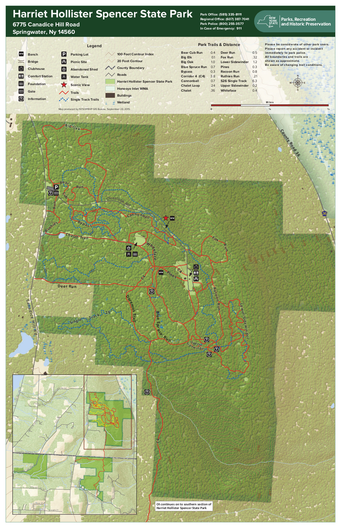
Overlook (Honeoye Lake Harriet Hollister Spencer (1887-1962) was born in Rochester, NY. She was a Charter Member of the Rochester Garden Club and was known as a rose expert. She designed the Garden of Fragrance at the Rochester Museum and Science Center and contributed roses from her own garden. In 1963, her family donated, at her request, 679 acres of land to New York State for the Harriet Hollister Spencer State Recreation Area.
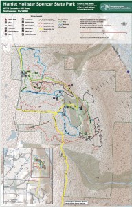 At 2000 feet, this park generally receives and keeps a good covering of snow each winter, and is one of four parks groomed for cross country skiing by the Rochester XC Ski Foundation.
Following the hike, an optional social will be at Sammy’s in Springwater.
The Naturalists will follow Bear Cub Run from the parking area to the snow shoe trail S6 just down the hill from the road. They will cross the overlook, cross Racoon Run, and then will make a short steep hike up to the loop at the end of the road. Then the Pines and Bypass trails will return to the parking area. Depending on the time, a hike to the north around the Big Oak trail may be possible.
The Tourists will similarly follow Bear Cub to the snow shoe trail, but will turn left on Racoon Run. Next is a left for a quick Fox Run loop, back to Racoon Run. Take the next left down to Lower Sidewinder, and follow that loop in a clockwise direction. At the information sign, we will stay to the left to follow a snowshoe trail across the snowmobile trail out toward Canadice Hill Rd and back. From their, heading north on Blue Spruce Run, Whiteface, and Cannonball, will bring us back to the road and the parking area.
The Climbers will follow Bear Cub Run to the road, and then will cross the road to follow the bypass and Chalet trails to the snowmobile trail. From there, we will follow the snowmobile trail south for about 2 miles, crossing into the town of Springwater, where we will turn west to reach the corner of Wetmore and Tibbels Road (which used to be named Springwater Canadice Town Line Road). Total length 3.3 miles, if we do not get lost.
Directions:
Check our standard directions to the HHS parking lot. Climbers coming from Springwater should meet at the corner of Wetmore and Tibbels Rd, to carpool to the parking lot. That way, we will have cars at the end of the hike.
From Springwater: (Climbers only): Take Route 15A north out of Springwater for one mile and turn right on Wheaton Hill Road. Continue to the top of the hill. At the T, turn left on Wetmore Rd. Stay on Wetmore, to the first road on the left (Tibbels Rd which used to be called Town Line Rd). You will see a welcome sign for Canadice. We will park on the right side, and car pool up to the parking lot.
Katherine J. T. Humphrey will present a discussion on what is new or current in home food preservation – like increased interest in fermentation, using less energy, using what is available locally and seasonally, deciding on what method of preservation would be best for a single person or for a household of many people, where to begin if a novice or an experienced home preserver, and the place to go for research based answers to questions, especially when it comes to safety and quality considerations.
Katherine was a full time Cornell Cooperative Extension Educator 1969-1991, and a CCE Livingston County Home Economics Program Leader. She has been a CCE Home Food Preservation Instructor since 1989.
A Through-Hike of the Colorado Trail
 The Little Lakes Sustainability Network and Springwater Trails are pleased to co-host a program on the magnificent Colorado Trail on Thursday, October 27, 7:00 PM at the Jack Evans Community Center (old Hemlock school) on Main Street in Hemlock. Light refreshments will be provided and everyone is welcome, free of charge. Donations to defray costs are encouraged.
Hemlock resident Bill Cooke will present information about the trail followed by a 25 minute slide show with music showing photos from his 2011 “through-hike.” He will share his deep appreciation of the natural environment fostered from many years of experience in long-distance hiking. Bill will also have copies of his book narrating the hike – Shades of Gray, Splashes of Color – A Thru-hike of The Colorado Trail – available for your perusal and purchase.
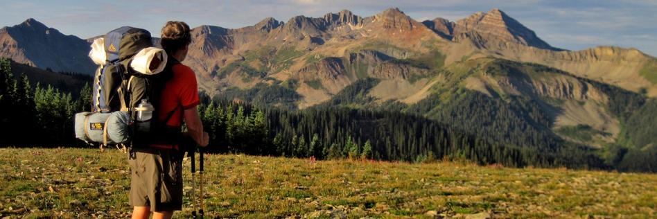
The 486-mile Colorado Trail wends its way through the Rocky Mountains of the Centennial State, traversing a landscape as changing and diverse as the swirling afternoon clouds presaging the daily summer thunderstorms. A common expression among long distance backpackers is “no pain equals no gain.” In this program, you’ll hear of the “pain” manifested in the struggle of acclimating to high elevations, of hiking long and steep ascents, of coping with a wide range of climatic conditions from freezing cold mornings to hot baking afternoons, to near daily thunderstorms and to long stretches of limited water. And you’ll see the “gains,” the triumphs as Bill and his hiking companion Keith “Northern Harrier” Bance savor the many rewards of this enchanting trail: alpine meadows whose wildflowers cover every range of the spectrum, bewitching groves of aspen trees resplendent with the morning glow of the sun, the glistening of snowy peaks, stately conifers including the massive Douglas firs, high mountain passes, dry foothills, sparkling mountain streams, gorgeous sunrises and sunsets where both the skies and the rocks shine like beacons from the low sun alpenglow, and much more.
Along the way, you’ll hear of the delight bestowed by such simple pleasures as a refreshing swig of Rocky Mountain water or a wildlife spotting. You’ll hear of fascinating near-daily cloud formations with their myriad shades of gray and ever-changing patterns. You’ll meet “Trail Angels” who emerge at the right place and time, unplanned and unexpected, to assist hikers with their basic needs, such as rides into towns for re-supplying or offers of water and snacks. And you’ll visit communities along the trail corridor, meeting the people in them, and enjoying the amenities that we all take for granted, such a hot shower, bed with linens, and meals of “real” food, all of which are especially appreciated by hot, dusty hikers.
Bill Cooke recently moved to Hemlock after living for seven years in Lexington, KY. He has backpacked for nearly 40 years. In addition to the Colorado Trail, he has hiked the entire Appalachian Trail, Vermont’s Long Trail, the Black Forest and Susquehannock Trails of nearby Northern Pennsylvania, and other trails around the country.
You need not be an experienced hiker to enjoy this program, as Bill explains much of the terminology and peculiar habits of long-distance backpackers. Even those whose experience is confined to short strolls in the park will sense the challenges and the rewards of a trek in the Rocky Mountains. Come and take a trip to the summertime Rockies!
The event is co-sponsored by the Little Lakes Sustainability Network and the Springwater Hiking Group, and is free and open to the public.
At 10:00 a.m. on New Years Day, you and your family and friends are invited to meet at at the Genesee Valley Greenway State Park’s Brook Road parking lot in the town of Chili. A walk one mile south will take us to the best preserved c.1840 Genesee Valley Canal lock on the entire trail. A walk two miles north will take us to the double-arch Genesee Valley Canal culvert which carried Black Creek under the old canal, a pretty special artifact built more than 170 years ago!
Directions:
Getting to Brook Road: Brook Rd parking lot, Chili, NY (Brook Rd is located off Scottsville Rd about 2 miles south of the intersection of Jefferson and Scottsville Roads. Brook Rd is a west turn only and the GVG parking area is only a few hundred feet down the road just past the Greenway crossing.
For those Springwater Trails hikers who revel in hiking Harriet Hollister Spencer State Recreation Area (HHSSRA aka HHSMRA where M is Memorial) with snow, well the ST hike on Sunday 1/22/2017 did not support that as the ground was devoid of the white stuff. But then it snowed on Tuesday 1/24/2017 and is predicted to do so again before Saturday 1/28/2017. Which leads me to citing a second chance for participation in a group hike where perhaps there may be snow, albeit this one on Saturday 1/28/2017 a mere 6 days since ST Sunday 1/22/2017 hike.
This hike is a scheduled hike on the Genesee Valley Hiking Club (GVHC aka GVHG where G is Group) hike schedule, and Ryan B. is the Hike Leader (& Planner). Some ST hikers are acquainted with Ryan as result of his hike leads and shared hiking enthusiasm.
The salient info for this hike is below in quotes, from the GVHC website. Hike start time is 10:00AM, likely most folks from ST will not benefit from use of the 9AM carpool as it is in Bushnell’s Basin. Please know that there are no dogs allowed on this or any other GVHC hike.
“January 28/Saturday Strenuous/hilly 6-7 mile hike. Harriet Hollister Spencer Memorial Recreation Area. Meet at Bushnell’s Basin Park & Ride at 9 a.m. Hike starts at 10 a.m. at Harriet Hollister. Ryan B. 802-999-8554 #6016″
( #6016 is the GVHC assigned sequential hike number for this hike.)
Rules for hikers on GVHC hikes are much the same as are rules for ST hikes, with the most glaring contrast perhaps being the no dogs rule. Please note the 12:30PM hike end time listed in this ST post is a mere guesstimate.
Of course, no guarantee that there will be snowpack on Saturday, and if not, well, no blamin’ the local meteriologist or weather-person. The adage … any hike is a good hike.
– – – And regardless of snow or not, Traction Devices (TDs) may be in order as trails can be icy even if there is no snow. There was a comment for the Sunday 1/22/2017 ST hike that trails were in fact icy!
Directions to the hike:
From Springwater: From 1 mile north of Springwater on Rt. 15A, turn right onto (and up) Wheaton Hill Rd. Drive all the way to Wetmore Rd. and turn left. Continue straight onto Canadice Hill Rd. and drive another 2 miles to the HHSSRA entrance road parking lot on the right.
From Honeoye: Take County Road 37 and continue straight onto Canadice Hill Rd. to the HHSSRA entrance road parking lot on the left
Note: The entrance road parking lot is siutate at Canadice Hill Rd & the entrance road (aka Overlook Rd) . This time of year the entrance road (aka Overlook Rd) may be gated to restrict “road vehicle” access past the entrance road parking lot. Regardless (gated or not), the hike meet point & start point is at the entrance road parking lot (Canadice Hill Rd & Overlook Rd), not the entrance road terminus which is much further “inside HHSSRA”.
This weekend, February 11th & 12th, 2017, you’ll have two Springwater Trails (ST) hike event opportunities. The Sunday hike is a “travel hike” to Steege Hill in Big Flats, NY. There is also a ST “Bonus Hike Event” on Saturday in form of a Hike Combo Event in Penfield, NY, … which is the subject of the ‘event post’ you are reading (here and now). This Hike Combo Event in Penfield is also a “travel hike”, albeit a closer travel than is Steege Hill.
The Saturday 2/11/2017 ST hike starts at 1:00PM in Penfield, NY. There are two separate start points for the ST hike event!!! In fact there are two different parks, both in Penfield NY, which are holding the hike routes and start points for this ST hike event. One hike is described as strenuous, hilly, 5-6 miles in length at Lucien Morin Park (aka Rifle Range Trail & more trails), a hike for ST Climbers. (Mildly stated, it is highly likely you’ll want TDs for this hilly hike at this time of year, be it snow/ice/mud for trail conditions. See the further description about TDs below.) The other hike is described as easy, ~ 2 miles on mostly flat trails, a hike for ST Tourists & Naturalists. After-hike social to be held at MacGregor’s Grill & Tap Room at 1129 Empire Blvd, Penfield.
This ST Bonus Hike Combo Event is scheduled in Penfield so as to conveniently sync with the 6th Annual Hikers’ Jamboree (HJ2017), which is badged as an “Indoor Hike” event, organized by Penfield Trails Committee (PTC), scheduled for 10:00AM-12:00Noon at Penfield Town Hall Auditorium situate at 3100 Atlantic Avenue, Penfield, NY. Following HJ2017, two outdoor hikes are subsequently provided at 1:00PM at two separate parks in Penfield, both with some included history components. This years program presentation for HJ2017 is on the famed railroad high bridge (viaduct) situate in Letchworth State Park. The viaduct high above the Genesee River is 140+ years old and will soon be replaced by a new viaduct. You’ll learn much more about these two viaducts at the HJ 2017 viaduct program presentation which runs ~10:30-11:40am. Penfield Town Hall is located at 3100 Atlantic Av, Penfield NY; ~ GPS coords 43.160959 , -77.446125
(Of note, many ST hikers will recall a ST hike on Oct 13, 2013 in Letchworth State Park where all three hiking subgroups by chance were on the trail near the base of this 1875 railroad high bridge, when we all had chance opportunity to view a train pass overhead! Thanks go to superb arrangement by that day’s Hike Planners Joan & Bob for the rare experience.)
During HJ2017 light refreshments will be served, so you’ll have sustenance/fuel opportunity before availing of choice of two outdoor hike locations with an 1:00PM start time. For easy reference and more info, here is an Event post about Hikers’ Jamboree 2017 as published on the ST website.
⇓ TWO HIKES ⇓ Start times for both at 1:00PM.
Those ST hikers desiring a Climbers level hike, (which will finish ~ 3:15PM), will hike in Lucien Morin Park, an “undeveloped” Monroe County Park, located at 1135 Empire Blvd. Climbers, as a ST subgroup, will actually be “joining-in” a GVHC hike that is led by Ryan B. (A number of ST hikers are previously acquanted with Ryan from previous hikes & socialization.) The hike start is at the entrance to Lucien Morin Park (a Monroe County Parks System park), the park entrance is off Empire Blvd near the foot of Irondequoit Bay, and situate immediately east of MacGregor’s Grill & Tap Room Restaurant (1129 Empire Blvd).
This hike will be hilly and will be adjacent Irondequoit Creek in some areas, and will traverse areas that were used in World War reserve troop training, including rifle training and more. Remnants of training areas still remain suggesting some of the training that took place. The “lost city of Tryon” lies on the the east side of Irondequoit Creek as does Tryon Park, an undeveloped Monroe County Park. Tryon Park can be seen accros the creek at various places on this hike.
Parking at Lucien Morin Park: There is a parking lot for this park at the end of the rather short park entrance road (entrance road runs off Empire Blvd). You can see the parking lot from Empire Blvd. Additional parking if needed can be had at MacGregor’s Grill & Tap Room Restaurant parking lot, said parking lot is immediately adjacent the park’s parking lot and entrance road. Please be respectful of this business who allows hikers to utilize the lot for overflow parking, if needed please park as far back in this business’s parking lot as is possible.
Being Climbers subgroup is joining-in a GVHC hike, GVHC hike rules apply (which are quite similar to ST hike rules). Perhaps the most glaring difference of hike rules … on GVHC hikes DOGS ARE NOT ALLOWED! So, if you want to hike with your dog on today’s ST provided for hike, you’ll need to do so with the Tourists/Naturalists which is wholly a ST hike (ie – not a join-in with GVHC).
Note: Climbers should expect many more hikers at this hike than ST hikers usually experience at a hike. Lucien Morin Park hike route is hilly and can be strenuous for some, but hey, that’s what Climbers are all about.
Naturalists & Tourists will hike in Ellison Park as accessed via Blossom Rd (at the bottom of Blossom Rd hill, ~1809 Blossom Rd). Ellison Park is a Monroe County Parks System park. Start point for this hike is in the parking lot on the north side of Blossom Rd, … the parking lot at the bottom of Blossom Rd hill that is not the “Dog Park” parking lot but is slightly east of the Dog Park parking lot. Well behaved dogs accompanied by owners are allowed on this Ellison Park hike route, where Gene will be the ST Hike Leader.
This Ellison Park hike route is mostly a flat route for an easy hike, substantially paralleling two bifurcations of Irondequoit Creek, reaching a memorial marker of an Indian trading post and site of Fort Schuyler where a reproduction of the original fort structure is situate.
⇓ TRACTION DEVICES, A HIKER’S FRIEND ⇓
Given that it is winter season, Traction Devices (TDs) may be in order (read … probably an excellent idea) for each of these two hikes routes. Lucien Morin Park trails are hilly and under certain conditions can be strenuous sans TDs. TDs help to tame the hills when they are slippery with ice &/or mud. Ellison Park trail route can also be slippery albeit the trail route is mostly flat. TDs such as Kahtoola MICROspikes, Hillsound Trail Crampons, Hillsound Trail Crampons Ultra, and similar, may be desirable on Lucien Morin Park hills, and same type or lesser aggressive TDs may be good for Ellison Park.
If your best guess is there is no snow and/or ice if hike day’s temps are higher than average, well… that could equate to mud on the hills which equates to a need for added traction. (A side note, I have under similar conditions seen hikers quickly return to the start point due to lack of having TDs and the trail being beyond their best adjudged capabilities without them.)
Hug The Trees, Please! When wearing TDs with spikes/cleats & similar … please be kind to trees … whenever possible anticipate your footing placement on the trail and step over tree roots, not directly on them which can puncture and damage roots & ultimately health of those trees and on larger scale the forest and ecosystem. Think about it … If you were lying on the trail gazing at the sky would you rather have a group of hikers wearing sharp piercing TDs step on you, or, step over you or around you. Safe to say if hikers were NOT stepping on you you’d be unscathed by those sharp cleats and spikes of said passing hikers, but not so if alternatively they stepped on you with those sharp metal cleats & spikes.
⇓ DIRECTIONS TO HJ2017 AND THEN TO TWO SUBSEQUENT SEPARATE HIKES ⇓
Directions to PENFIELD TOWN HALL AUDITORIUM, 3100 Atlantic Ave aka NYS Rt 286. For Penfield Trails Committee’s (PTC) “Indoor Hike” aka Hikers’ Jamboree 2017 scheduled 10:00AM-12:00Noon. From points south of Rochester take expressway I-390 northbound, to expressway Rt 590 northbound, to exit for Browncroft Blvd / NYS Rt 286, head east on NYS Rt 286 which is also Browncroft Blvd and which will change names to Atlantic Avenue at the intersect with Whalen Rd & Scribner Rd 4-way intersection, continue on NYS RT 286 / Atlantic Avenue to just past Jackson Rd and then turn let into the Penfield Town Hall driveway.
⇓ Directions: to the two separate hike start locations (1:00PM hike), from Penfield Town Hall. ⇓
To LUCIEN MORIN PARK (1135 Empire Blvd) – NO DOGS ALLOWED on this hike: From Penfield Town Hall utilize Town Hall’s entrance/exit drive aka Columbus Crossing (westbound) to Jackson Rd and turn right onto Jackson Rd, proceed northbound on Jackson Rd to Plank Rd & turn Left, proceed on Plank Rd to Empire Blvd, turn left onto Empire Blvd and near the bottom of the Empire Blvd hill on the left you will find the entrance drive to Lucien Morin Park. (It is immediately adjacent MacGregor’s Grill & Tap Room Restaurant.)
To ELLISON PARK (~1809 Blossom Rd) – DOGS ARE ALLOWED on this hike: From Penfield Town Hall utilize the Town Hall’s Atlantic Av aka NYS Rt 286 entrance/exit drive, turn right heading westbound onto NYS RT 286 aka Atlantic Av, continue on NYS RT 286 / Atlantic Av westbound (realizing Atlantic Av will change names to Browncroft Blvd at the intersect with Whalen Rd & Scribner Rd 4-way intersection), continue on NYS RT 286 / Browncroft Blvd to the 4-way intersect with Creek St and Blossom Rd, turn left onto Blossom Rd and proceed on Blossom Rd down a winding hill to the Ellison Park parking lot on the right which is is slightly east of the Dog Park parking lot. (hints: There is a porta-potty at the far west side of this hike meet parking lot, and also a winter ice skaing rink immediately contiguous to the west side of this parking lot. Hike Meet point is about in the middle of this designated parking lot. If as you travel on Blossom Rd, you reach the dog Park parking lot, you went to far and have passed the designated hike meet parking lot.)
⇓ Directions: to the two separate hike start locations (1:00PM hike), from points south of Rochester. ⇓
Directions to LUCIEN MORIN PARK: – take expressway I-390 northbound, to expressway Rt 590 northbound, to the exit for NYS Rt 404 / Empire Blvd exit, head east NYS Rt 404 / Empire Blvd to the bottom of the hill / foot of Irondequoit Bay, Lucien Morin Park (1135 Empire Blvd) entrance road and parking lot is immediately east of MacGregors Grill & Tap Room Restaurant at 1129 Empire Blvd.
Directions to ELLISON PARK: – take expressway I-390 northbound, to expressway Rt 590 northbound, to Blossom Rd exit, head east on Blossom Rd to the bottom of the hill, where Ellison Park will then be on both sides of Blossom Rd. Ellison Park parking lot for this hike is on the north side of Blossom Rd (a left turn into the lot), further described as the parking lot at the bottom of Blossom Rd hill that is not the “Dog Park” parking lot but is slightly east of the Dog Park parking lot. (If you reach “Gatherings Catering” Company – at “Daisy Flour Mill” Party House / Restaurant, situate in the circa 1840 Daisy Flour Mill building, on the right side of Blossom Rd, you’ve gone too far.)
AFTER-HIKE SOCIAL & ⇓ Directions thereto ⇓: After-hike social is at MacGregor’s Grill & Tap Room Restaurant [phone=288-8630] located at 1129 Empire Blvd next to Lucien Morin Park. So Climbers will merely walk nextdoor from the hike end portal to MacGregor’s.
Naturalists/Tourists will need to drive to the social. From Ellison Park on Blossom Rd head east up a long winding hill, at the 4-way intersection of Blossom Rd & Creek St (where Browncroft Blvd aka Rt 286 intersects) continue straight onto Creek St, at Plank Rd turn left, at Empire Blvd turn left, at the bottom of Empire Blvd hill & the foot of Irondequoit Bay will be MacGregor’s of the left.
Springwater Trails (ST) and Genesee Valley Hiking Club (GVHC aka GVHG) both provide their hikes as open to the general public, no need to be a respective member to hike with either group. Hike rules as set by respective groups and Hike Leaders apply.
Victor Hiking Trails (VHT) will be leading a hike this Saturday 3/25/2017 at 8:00 a.m. from “the Apple Farm” to Boughton Park, around the two ponds (aka former reservoirs) in Boughton Park and back to “the Apple Farm”, a distance of 9 to 11 miles, rated as strenuous and hilly. Guesstimate of 3.5 – 4 hour hike (thus end time on 12;00 Noon listed in the heading of this hike event announcement is an approximation). **Traction Devices (TDs) will be very helpful for this hike (understated), given terrain and known conditions at this time of year.
The hike is part of the hike series of Genesee Valley Hiking Club (& GVHG Meetup). All hikers are welcome. Anyone who is interested is encouraged to sign up on the GVHG Meetup. – – For this hike, parking and hike start point is at the Apple Farm. – –
(Of note, Springwater Trails hikers have hiked a few of our weekly Sunday hikes in Boughton Park.)
As in part described, this hike will cover not only parts of Boughton Park but also substantial mileage on the Seneca Trail and the spur trail that is within “the Apple Farm” (aka the Victor Apple Farm).
FYI – as was in the news – “the Apple Farm” (in Victor), located at 1640 NYS Rt 444 (on the west side of Rt 444), sustained a fire in the sales and office building on November 4th 2016, a total loss. The remainder of the farm structures and orchard remain intact, and intent is to rebuild a sales and office building.
The Apple Farm is one of many property owners who grants access for hiking trails on privately owned property.
One thought for a possible future hike – – plan a hike in the autumn at the Apple Farm, and provide for post hike apple picking (perhaps as a social event itself, or as part of a social that may be held at the Apple farm where picnic tables are provided, or separate from a social). A symbiotic hike event, such that the Apple Farm as landowners provides hiking trails (and access thereto), and hikers support the business of the landowners by purchasing apples and other goodies.
– – Back in the day, if this author recalls correctly, Maple Syrup from Sugarbush Hollow located in Springwater (owned by dearly departed Chuck Winship, a ST hiker and avid supporter of ST) was offered for sale at the Apple Farm store. – –

I Love My Park Day (ILMPD) is annually held on the first Saturday of May, a NYS Parks initiative. May 6th 2017 is the the 6th annual ILMPD and there are numerous opportunities in which to become involved on ILMPD. Many NYS Parks have planned activities for ILMPD, and many of the activities are targeted with improvement of the respective park.
Info is available on “Parks and Trails New York” website at a special webpage = www.ptny.org/ilovemypark Information also may be available for some opportunities and activities on the NYS Parks website. (Of note, the www.ptny.org website also holds information on numerous other observances and opportunities that occur throughout the year, all targeted at outdoor areas for recreation, relaxation and enjoyment.)
The three STATE PARKS closest to the homerange of Springwater Trails hikers that have participating opportunities in 2017 are Genesee Valley Greenway State Park (aka GVG), Stony Brook State Park, and Letchworth State Park.
GENESEE VALLEY GREENWAY STATE PARK
FOGVG website (in conjunction with the GVGSP) has posted info about opportunities in the Genesee Valley Greenway State Park for ILMPD 2017. FOGVG Facebook page
A clean-up event in Little Black Creek Park, located off Scottsville Rd along the GVG (Chili, Monroe County), is scheduled at 9:00AM-12:00Noon. There is a former Genesee Valley Canal culvert and waste weir on the GVG in Chili, so there’s an opportunity to learn and view some history at this clean-up event. (Details can be gleaned from the FOGVG Facebook page.)
FOGVG is also leading a hike on miles 80-83 of the GVGSP at 10:00AM May 6th, in Allegany County near the hamlet of Black Creek. (Details can be gleaned from the FOGVG Facebook page.)
STONY BROOK STATE PARK has a participatory event scheduled from 10:00AM-12:00Noon; meet at Clara Barton Shelter near the main parking area. One of the planned activities is picking up of the gorge trail, which seasonally closed Nov 19, 2016. (You can be one of the first this season to traverse the Gorge Trail on this day.) Grounds cleaning, Ball Field improvements and grass seeding are also among some activities.
LETCHWORTH STATE PARK from 8:30AM – 1:00PM has planned the following participatory events. Project/Event Description: Leaf and trash removal, garden cleaning, stone staircase maintenance (Shoveling), Playground maintenance, and invasive plant removal. Meeting Location is at Trailside Lodge. All ages welcome.
These are merely a small smattering of the opportunities to participate in during ILMPD – NYS 2017. – – – If passing through a park admission gate enroute to ILMPD 2017, be sure and inform the staff that you are participating in ILMPD efforts, and ask for directions to the meeting location if you need direction.
Looking for brochure.or mailing list so I can receive it in the mail.
Nothing opens up for mailing list.
There’s all kinds of very bizarre ads and post for viagra and other drugs above on calender page.
Please let me know if there’s a brochure available