
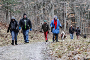
Hikes led by Springwater Trails are generally held on Sunday afternoons and appear in this calendar in green.
| Sun | Mon | Tue | Wed | Thu | Fri | Sat |
|---|---|---|---|---|---|---|
| December 1 Hike at Wesley Hill Preserve 2:00 pm December 1 Hike at Wesley Hill Preserve @ Wesley Hill Nature Preserve Dec 1 @ 2:00 pm – 4:00 pm  Wesley Hill Nature Preserve Although we have visited this preserve numerous times over the years, it is good to pause and reflect on the history of this gem of the Finger Lakes. Over one hundred years ago, after the sawmills … Continue reading | ||||||
| Mount Hope Cemetery Hike 2:00 pm Mount Hope Cemetery Hike @ Mount Hope Cemetery (Rochester) Dec 8 @ 2:00 pm – 4:00 pm  Mount Hope Cemetery in Rochester, NY is one of the most remarkable Victorian cemeteries in America. Since the cemetery’s dedication in 1838, a third of a million people have taken permanent residence in this exquisitely beautiful 196-acre site. Hikers will … Continue reading | ||||||
| Schribner Valley Hike 2:00 pm Schribner Valley Hike Dec 15 @ 2:00 pm – 4:00 pm 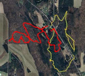 Please join us for a hike around our property and that of our wonderful neighbors. Following our hike, please join us for a holiday celebration social at our home. We have two hikes planned. We did pre-hikes on the 6th … Continue reading | ||||||
| Middlesex Valley Rail Trail 2:00 pm Middlesex Valley Rail Trail Dec 22 @ 2:00 pm – 4:00 pm 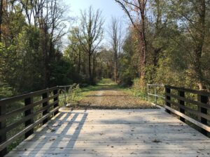 WEATHER UPDATE: Good cross country ski conditions, bundle up for cold temperatures! The trail has about 3″ of snow in both directions, so bring your cross country skis if you’d like to try skiing the trail. On Saturday the snow … Continue reading | ||||||
| NO HIKE Scheduled 2:00 pm NO HIKE Scheduled Dec 29 @ 2:00 pm – 4:00 pm No hike has been scheduled for this date to allow time for rest and relaxation off the trails. |
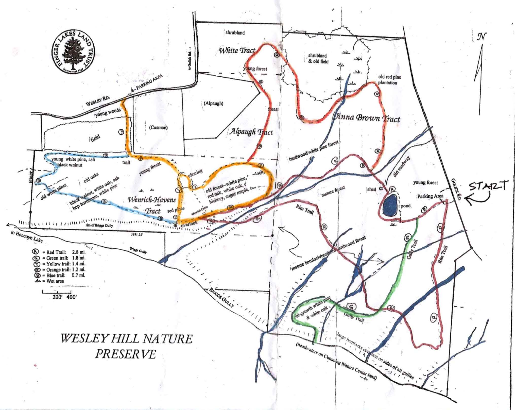
Although we have visited this preserve numerous times over the years, it is good to pause and reflect on the history of this gem of the Finger Lakes. Over one hundred years ago, after the sawmills of the Bristol Hills fell silent, white pine, hemlock, and oak seedlings began to sprout along the northern rim of Briggs Gully, one of the largest gorges in the Finger Lakes. The peaceful beauty of the forested glens and groves inspired three artists–John Wenrich, James Havens, and Colburn Dugan–in 1926, to purchase a 90 acre parcel which forms part of the preserve. They built the cabin, which we will visit on our route, as a retreat. Their children, who inherited this small paradise, entrusted its care to the Finger Lakes Land Trust, who purchased it and additional parcels in 1999, then added a land grant from Chris White to create what is now the 390 acre Wesley Hill Preserve.
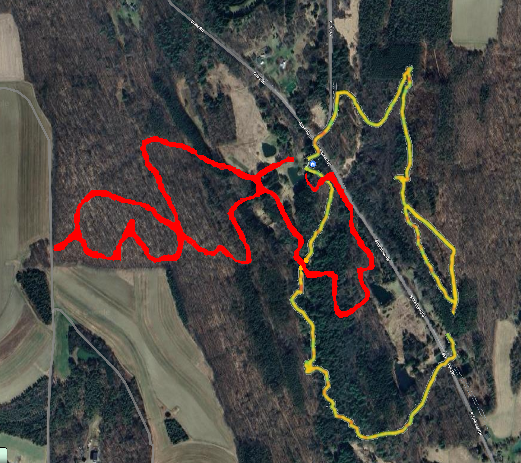
At this time bowhunting is permitted on 2 of the trails (Blue and Yellow) thus they are closed to hiking. Please respect this. Our hikers will be traversing the Red, Orange, and Green Trails.
All hikers will meet at the Gulick Road Parking area. Please be ready to hike at 2:00 PM. Hiking boots and poles are highly recommended as the terrain is uneven and slippery in places. To begin, all groups will head west on the Red Trail, around the pond and into the woods.
Naturalists will follow the Red Trail downhill toward the cabin along a lovely gully. The cabin is in poor condition, but provides a glimpse into the past. There is a guest book and some interesting artifacts on the porch. Hikers may be able to proceed a short way past the cabin on the Yellow Trail to a terrific overlook of Briggs Gully and Harriet Hollister Recreation area in the distance. If there is a closed sign, then they will need to head back up hill on the Red Trail to the pond and Parking area. Hike distance about 2 miles.
Tourists Shortly after the pond this group will turn right onto the Orange blazed trail. They will follow this trail for1.2 miles to an intersection with the Yellow Trail. Turning left on Yellow will lead for .1 miles through the woods to the Red Trail . At this point they can turn right downhill and walk to the cabin and Briggs Gully overlook. They will then turn back up hill on the Red and follow it back to the pond and parking area. Total Distance about 3 miles.
Climbers Be prepared for some climbing. Following the Red Trail downhill from the pond, at the cabin turn left on Red down into a lovely gully and stream. There is a steep uphill from the stream, up some rock steps with a railing and rope to help you climb. Please use caution. The Red Trail continues uphill along the gully, then flattens out at .7 miles where it reaches the Green Trail intersection. The plan is to turn right and proceed downhill for .4miles into the famed Briggs Gully. It is a steep rocky trail, but worth the trip. If folks are not up for it, we can simply continue on the Red Trail which leads back to the parking area. Total trip about 4 miles.
From Honeoye: take route 20A east through Honeoye to East Lake Road (CR 33). Turn right onto East Lake Road. (If coming from Bristol or points east, it’s a left onto East Lake Road). Take the first left, staying on CR 33, then the first right onto Pinewood Hill which becomes Gulick Road. Travel about 5 miles to Wesley Hill Parking Area on the right side. Parking lot can fit about 16 vehicles; any late comers can park on the side of the road.
From Springwater: Head north on Rte. 15A toward Hemlock. Just before Hemlock, turn right on Rte. 20A. Follow Rt 20A to Honeoye and then follow the directions above.
From Naples: From the southern end of Naples, head west on Co Rd 36. Follow Co Rd 36 for 1.2 miles to the first right turn on Gulick Rd. Follow Gulick for about 7 miles, past Cumming Nature Center. The parking area is on the left.
The trail map for Wesley Hill is here: Wesley Hill Preserve
After taking a head count to make sure that no one has been left behind, We will gather at The Birdhouse Brewery on Main Street(RT.20A) in Honeoye for food and beverages.
The Holiday Market (local artisans) will be there as well as musical entertainment by Stephen Morrell.
Mount Hope Cemetery in Rochester, NY is one of the most remarkable Victorian cemeteries in America. Since the cemetery’s dedication in 1838, a third of a million people have taken permanent residence in this exquisitely beautiful 196-acre site.
Hikers will walk the grounds on flat paved roads exploring thousands of monuments made from granite, marble, limestone, sandstone and bronze etc. fashioned into Greek temples, soaring Egyptian obelisks, ornately carved steles and columns, winged angels, bas relief portraits, stone figures in flowing robes along with flora and fauna of exquisite detail.
Along the way, hikers will also stop to visit some of the well-known graves including Susan B Anthony, Frederick Douglass, Nathaniel Rochester and William Warfield to name a few. For additional information, check out Friends of Mt. Hope Cemetary www.fomh.org
Hikers will meet at 1:45pm at the North Gate entrance parking area in front of the 1862 chapel.
Social
Following our hike, join us for a social at Elmwood Inn– 1256 Mt. Hope Avenue, Rochester, NY 14620 (practically a stone’s throw from the cemetery entrance.)
Directions
Mt Hope Cemetery is about 45 minutes north of Springwater, so carpooling should be considered.
From Springwater: Head north on NY 15A for 19 miles to Lima. Turn left on US-20 for 4.2 miles. Turn right onto I-390 N. At the split with 590, stay left on I-390 and then stay right to exit 16B for NY 15A/E Henrietta Rd. Continue straight past South Ave and turn right onto Mt Hope Ave. Go up and over the hill for 1.8 miles to the second entrance to the cemetery (north entrance). There is parking inside the entrance.
From Naples: Take CR-36 (West Lake Rd) to Honeoye. Turn left on US-20A. In 5 miles turn right onto NY-15A and follow the Springwater directions.
Please join us for a hike around our property and that of our wonderful neighbors. Following our hike, please join us for a holiday celebration social at our home.
 We have two hikes planned. We did pre-hikes on the 6th and 7th in 6 inches of snow. The trees were beautiful, with snow caught on all the branches. But most of the snow will be gone soon, and I can’t predict the weather for Sunday. Expect wet conditions so waterproof boots and walking sticks will be helpful, although not required.
Linda will be leading the Tourist/Naturalists on a new trail along our creek. This trail follows the creek through native woods with three crossings of the creek on stepping stones. We then climb a short hill out of the lower part of the valley to an open field, and continue up past my niece’s cabin through a managed woods and back to the house. Adjustments may be made based on time.
Meanwhile, Mark will lead the Climbers up trails to the top of our hill, exploring the various trees and likely a bit of family history on the way. We will do a loop through the forest, back down to the creek, and finish along part of the Tourist trail to house.
Following the hike, please join us for a dish to pass holiday social. We will have a ham to share. Please bring a dish to pass and your preferred beverage or contribute $5 to the social fund.
Please click on Directions above for complete directions to the hike. When you arrive, you may park in the driveway or on the road. Remember that it will be dark after the social, so you may want to turn you car around while parking to simplify your escape later.
If you use your GPS, it may recommend coming by way of Strutt St in Springwater. This will take you on dirt roads. Do not turn on Schribner Rd from Strutt St, because that road is nearly impassable. Instead, go south on Strutt St from Schribner and continue straight up the hill on Quanz Rd. Continue past Fox Rd and turn left on Giles Rd. Take it easy, and you should make it. I suspect next time you will follow the directions via Tabors Corners.
From Honeoye: Take Rt#36 south into Naples, left on Main St for approximately 1.25 miles. Right on Rt#245 (Across from Bob and Ruth’s). Continue 1.5 miles then left on Parrish Rd. Parking area is on the right, in about .2 miles.From Canandaigua: Take Rt#21S to Woodville. Keep straight toward Naples. Turn left on Parrish Road about 1.5 miles past Woodville, just after you pass Monica’s Pies. The parking area will be on your left, in about .5 miles.
No hike has been scheduled for this date to allow time for rest and relaxation off the trails.
The Hike:
Start the New Year the way you mean to go on – come for an inspiring hike along Canadice Lake!
This is an easy, 1.8-mile each way hike along the shore of the lake; the trail is level and well-maintained and the lake views are lovely. For most hikers it will be a walk along the lake for an hour or so, and then back the same way; more enthusiastic hikers can veer off on Rob’s Trail that leads over the ridge and down to Hemlock Lake – this is a moderate to hard trail with several steep uphill and downhill sections.
We’ll take a roll call the day of the hike if anyone wants to walk Rob’s Trail. We’ll arrange for transport back for those who only want to walk one way. Dress appropriately for the weather, carry water and some energy food, and carry a walking pole if it helps. Leashed pets are welcome.
This is not a “routine” Sunday hike – it’s special because the hike is promoted by the NYS DEC, and is part of a larger program of First Day Hikes to encourage people to get out and experience the magnificent State of New York that they live in! The DEC, State Parks, and the Canal Corporation invite New Yorkers to kick off 2025 by participating in one of the many hikes being held at state parks, historic sites, wildlife areas, trails, and public lands across the Empire State. All hikers will leave with a memento of the hike and will be eligible to win an Empire Pass the allows entry to most state parks across the state.
Please note that the First Day hike this year is scheduled from 2:00pm-4:00pm, giving everyone a little more time to get over the night before.
The Meet-Up Location
All First Day hikers will meet at 1:45pm in the parking area off Purcell Hill Road, Town of Canadice, Ontario County. Google Maps (leaves this website) Click here for directions. Please plan to arrive early enough to park and get dressed for the weather conditions.
The Social
There won’t be an organized social on this hike.
When: January 5, 2025 @2pm-4pm
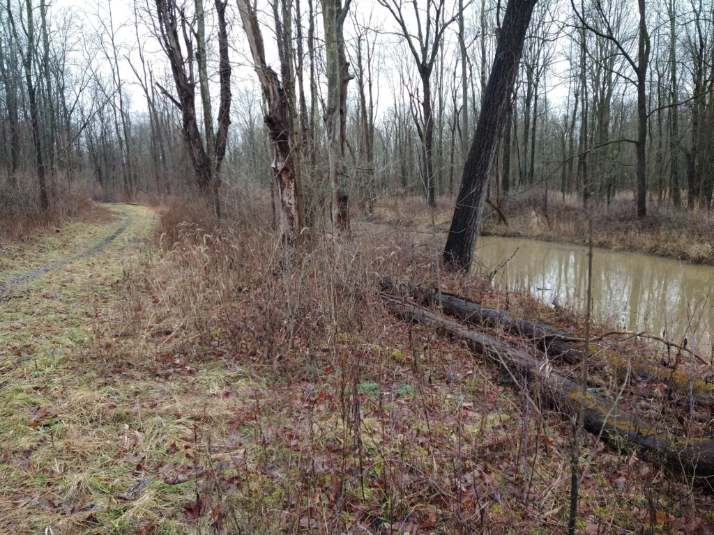
Please join us on 1/05/25 at the NW corner of Hemlock Lake (42.77772, -77.61891) to hike Bur Oak Trail and the Walnut Trail, both on State land within the Canadice Hemlock State Forest. One section is a snowmobile trail and the other travels thru the woods parallel to the shoreline. For those who enjoy stony beach walking, there will be an opportunity for that too.
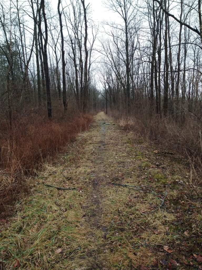
Bur Oak Trail – This trail is a well-marked 3-mile snowmobile trail winding through the woods, crossing small streams, running alongside the Hemlock Lake outlet stream, then gradually heads uphill to a gate and the upper loop. The loop will take us thru an open field, by a few ponds, a marsh, and then up near the top of Blank Road. At that point, you return the way you came. Many side trails just fizzle out so stay on the main trail.
Walnut Trail – This trail follows an old road near the northwestern shore of Hemlock Lake. You might find the ruins of foundations of the former homes that once were on the lake. There are a couple of deep ravines the trail traverses. The trail ends at the second deep ravine about 3/4mile in. Just before that ravine, there is a short trail to the left, that leads to an iron plate off of some old equipment.
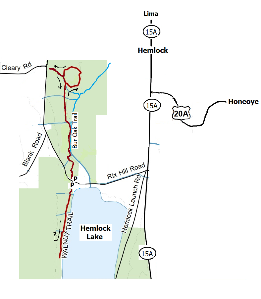
Meet at 1:45pm at the northwest corner of Hemlock Lake at the Rix Hill Road trailhead parking area just west of the Hemlock Outlet and Hemlock Lake State Park. There are small parking areas on both sides of the road, and a kiosk on the south side.
Naturalists will first follow the Bur Oak Trail north for about 1/2mile and then return to the start. Then they will cross the road and continue on to follow the Walnut Trail south through the woods for about 1 1/2 mi round trip. This requires some agility in stream crossing. At the end of the trail, we will vote on either returning the way we came or take a path down to the shoreline, walk a bit, then head back to the parking lot.
Bring good waterproof winter footwear and poles. Those wanting a shorter hike will have ample opportunity to bail out as we pass the starting point. At the end of Walnut Trail, there is a very steep climb that some bold hikers take down the ravine to get to the shoreline. It is advisable that if you want to walk the beach, it might be safer to double back the way you came to where a flagged path makes a much safer trip down to the water. There is another flagged path to get back up to the trail, and then back to the parking lot.
Directions: from Honeoye and points east: From Honeoye, continue west on Main Street (Route 20A) to Route 15A in Hemlock. Make a left, go a half mile, and take a right on Rix Hill Road. Pass the park entrance on your left and go over the Hemlock Outlet bridge. The parking areas will be on both sides of the road, or park on the shoulder.
PLEASE NOTE: This is a change from the earlier posted hike location, as Hickory Ridge is closed for the winter.
Please join us on Sunday January 12th for a winter hike along Naples Creek between Mark Circle and Route 245, with an optional detour into the trail systems of Naples Community Park and Hi Tor. This is a flat and easy basic hike, with more of a workout for those who want some elevation.
Meet at 1:45 for a 2PM start at the large parking area on the north side of Mark Circle, just beyond the small Fishing Access lot, All groups will head east along the Naples Creek Trail. Tourists and Naturalists will follow along the creek to Ontario Street and back (about 1.5 miles) or all the way to Route 245 and back (about 3 miles). Climbers will follow the creek trail to the Finger Lakes Trail intersection, then head up into Hi Tor briefly and return via Naples Community Park, then returning along the creek to Mark Circle, for about 4-5 miles. Trails are in good condition, with a light snow cover. Bring poles and good traction footwear if you intend to go up the hill into Hi Tor.
Our Social: Join us afterwards at the Redwood Restaurant, 6 Cohocton Street,Naples (on Route 21 just west of the intersection with Route 53 to Prattsburgh).
For menu see https://redwood-restaurant.jimdosite.com/menu/
Directions:
From Springwater: Go south to Wayland and east on Route 21, to Naples. Turn right on Mark Circle, just past the Middletown Tavern. The parking area is on your left, just past the Lost Sock and the fishing access and bridge.
From Honeoye: Go south on County Road 36, coming into Naples next to the Middletown Tavern. Make a left on Main Street, then take your first right on Mark Circle. The parking area is on your left, just past the Lost Sock and the fishing access and bridge.
From Rochester/Victor/Canandaigua: Follow 5 and 20 to Route 64, then south to join Route 21 at Bristol Springs. Continue into Naples and through the center of town. Turn left on Mark Circle, just before the Middletown Tavern. The parking area is on your left, just past the Lost Sock and the fishing access and bridge.
To the Social: Return to Main Street, go left and then bear right at the intersection with Route 53. The Redwood is the second building on your left.

This Sunday’s hike will take us back to an old favorite, Mendon Ponds Park, with well-marked trails and much to see in every season!
Mendon Ponds Park is the largest Monroe County Park with 2,500 acres of woodlands, ponds, wetlands and glacially created landforms. In 1969, it was named to the National Registry of Natural Landmarks due to its geologic history and presence of significant kames, eskers, and kettles.
Hike Details:
We will meet at Lookout Shelter (45 County Rd Honeoye Falls, NY 14472) parking lot off of Pond RD near Douglas RD at 1:45pm. We’ll split into two groups for this hike. Please come prepared for the weather conditions and bring your pole(s) if you use them.
- The Naturalists and Tourists will hike the flat trail around Quaker Pond for 2.8 miles. This hike will take us through beautiful woodlands with stunning views of the Pond and surrounding wetlands.
- The Climbers hike will be a mix of rolling hills with a few steep climbs through open fields and woodlands for 4.3 miles. This area of the park exhibits some amazing geologic features such as kames, eskers, and kettles (oh my!)
Both hikes will have an opportunity to hand feed birds! Bird seed will be provided.

Social Details:
For the social afterwards, thirsting hungry members can head over to Fireside Grill & Sports Bar at 3939 E Henrietta Road, Henrietta, NY 14467 www.firesidegrillsportsbar.com
Directions:
From Springwater: Head north on 15A for 21.6 miles through Hemlock and Lima. Take a right at the exit to Honeoye Falls. Stay on W Main St into the village where you will pass the Flaherty’s on the right. Continue straight onto NY 65 for 4.4 mi. (At 2 miles, you will go around a traffic circle. Stay on NY 65.) Turn right onto Pond Rd at the park entrance. Meet at Lookout Shelter parking lot off of Pond RD near Douglas RD
From Honeoye: Take US 20A west and head north on CR 37 for 8.2 miles to W Bloomfield. Continue straight on NY 65 for about 3 miles, and make a right on Quaker Meeting House Road just before you come into Honeoye Falls. When Quaker Meeting House Road ends at Route 251 (Rush-Mendon Road), go left and then right on Route 65/Clover Street. The Pond Road entrance to the park is about 2 miles to the north, on the right. Meet at Lookout Shelter parking lot off of Pond RD near Douglas RD
From Rochester: Exit I-590 at Monroe Ave toward Pittsford. Turn right (south) onto NY 65 (Clover St). In about 6.7 you will come to the Canfield Road entrance to the park – this is not the one you want. Continue another 1.5 miles, then turn left onto Pond Rd, the second entrance into the park. Meet at Lookout Shelter parking lot off of Pond RD near Douglas RD
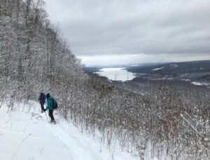
Our Sunday event will be a cross-country ski or snowshoe excursion on the groomed trails of the Finger Lakes State Park Region’s Harriet Hollister Spencer State Recreation Area. Because of the high elevation (over 2000 feet), the Park has been well used over the past few weeks of cold, snowy weather, and the groomers have kept the trails in great condition for both fast and slower skiers and for those on snowshoes.
Meet at 6775 Canadice Hill Road in the Town of Canadice, Ontario County. Park in the main lot near the road and gather near the kiosk at 1:45pm for a 2:00pm start. Rest rooms are available next to the lot. We will divide into groups depending on desired activity and distance.
- Cross Country Ski – A good easy run for skiers is the Overlook Road to the Raccoon Run trail and back.
- Snowshoe – A good route for those on snowshoes is an out and back on the Overlook and Bear Cub trails.
- Naturalist’s Hike – Hiking in the winter is limited because the trails are groomed for use by skiers and those on snowshoes. However, the Overlook Road is wide enough that hikers can go out and back (for a total of about 2 miles) without having to worry about colliding with skiers or post- holing the tracks. Poles and traction devices are recommended.
Trail Map
The trails are not well marked so it is recommended that you take a photo of the trail map at the kiosk or print a trail map using this link –https://parks.ny.gov/documents/parks/HarrietHollisterTrailMapWinter.pdf
Directions to Harriett Hollister Spencer State Recreation Area
From Springwater take East Avenue up the hill and then a left on Canadice Road (CR42). Make a right on Town Line Road (aka Tibbals). At the end, make a left on Canadice Hill Road. Go about 1.7 miles to the park entrance on your right.
From Honeoye/Hemlock take Route 20A east from Hemlock or west from Honeoye to the intersection with County Route 37. Go south approximately 3.7 miles to the point where County Route 37 curves to the right; go straight here on Canadice Hill Road. In about 3.2 miles the park entrance and parking area will be on your left.
Social
The social afterwards will be at Tee & Gee Bar and Grill, 6028 Big Tree Road, Lakeville, NY 14480 (585) 346-7387
Directions to Tee and Gee: From the park entrance go right on Canadice Hill Road for 3.2 miles to where it intersects County Route 37. Head straight (north) on County Route 37 for 3.7 miles. Turn left onto US-20A W / Honeoye Rd. (4 miles.) Turn right to stay on US-20A W / NY-15A / Main St (2.1 miles.) Keep left to stay on US-20A W / Richmond Mills Rd (proceed 4.5 miles.) You made it! Arrive at US-20A W / NY-15 / Big Tree Rd. The last intersection before Tee & Gee is Junior Crescent. If you reach Camp Run Dr, you’ve gone too far. Turn around and come back. Don’t worry, we’ll save you a seat!
Looking for brochure.or mailing list so I can receive it in the mail.
Nothing opens up for mailing list.
There’s all kinds of very bizarre ads and post for viagra and other drugs above on calender page.
Please let me know if there’s a brochure available