
Hikes led by Springwater Trails are generally held on Sunday afternoons and appear in this calendar in green.
| Sun | Mon | Tue | Wed | Thu | Fri | Sat |
|---|---|---|---|---|---|---|
| A Hike Along the Hemlock Lakeshore and Rob’s Trail 2:00 pm A Hike Along the Hemlock Lakeshore and Rob’s Trail Mar 5 @ 2:00 pm – 4:00 pm 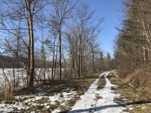 This Sunday we will enjoy a leisurely stroll along the Hemlock Lake shore on the northwest section of Rob’s Trail. The Climbers will continue up Rob’s Trail to Route 15A, and from there they’ll be ferried back to the hike … Continue reading | ||||||
| Snowshoe/Ski/Hike at HH Spencer Park 2:00 pm Snowshoe/Ski/Hike at HH Spencer Park Mar 12 @ 2:00 pm – 4:00 pm Please join us this Sunday for a cross country ski, , snowshoe or hike, while exploring a hiking site not far from Springwater. A few years ago New York State acquired several new parcels of land to the south of … Continue reading | ||||||
| Ellison Park Hike (43.1510, -77.5133) 2:00 pm Ellison Park Hike (43.1510, -77.5133) Mar 19 @ 2:00 pm – 4:00 pm 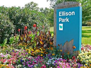 Our Spring Equinox hike this year will be in Ellison Park in the City of Rochester. This city park dates back to 1926, and covers 447 acres of city land. It has woodlands, steep slopes and the level flood plain … Continue reading | ||||||
| Greenway RailTrail Hike or Bike, north from Avon 2:00 pm Greenway RailTrail Hike or Bike, north from Avon Mar 26 @ 2:00 pm – 4:00 pm 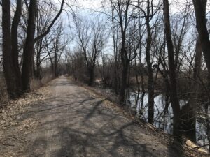 This is a change from the earlier published schedule. The Letchworth Park hike will be rescheduled for a Sunday later in the spring. On Sunday the 26th, we will hike or bike on the Genesee Valley Greenway from Route 20 … Continue reading |
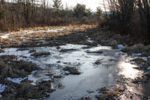
This Sunday we will enjoy a leisurely stroll along the Hemlock Lake shore on the northwest section of Rob’s Trail. The Climbers will continue up Rob’s Trail to Route 15A, and from there they’ll be ferried back to the hike start point; Naturalists and Tourists will stay on the lake shore trail and turn back to the start point whenever it suits them. The mild winter will continue this week so we’re not expecting much snow cover. If the lake level is low we can walk on the beach, but the trail offers a good flat and mostly well-drained surface. Here and there we will encounter a minor stream to cross by either wading or jumping, so waterproof footwear and poles are advised. Just in case of lingering ice or slippery mud, spikes or Yaktrax are a good idea too.
Meet at the north boat launch, at the end of the old east lake road, a sharp left after you first enter Rix Hill Road from Route 15A. This will be an out and back hike for Naturalists and Tourists; may return at any point; while Climbers will walk all the way to Route 15A for a shuttle back to the start point. At about 1.75 miles we will encounter a more substantial stream across the trail, probably too large to leap over. Any Climber wishing to proceed on Rob’s Trail past this point is advised to bring wading boots. Turning around at this point will give you a hike of 3.5 miles and a little under 2 hours.
Optional Social: Please join us at the Birdhouse Brewing Company in Honeoye – 8716 Main Street, just east of the traffic light, for craft beer and pub food.
Directions: From Springwater: proceed north on Route 15A 19 miles, then make a left on Rix Hill Road and an immediate left on Old East Lake Road, aka Boat Launch Road.
From Honeoye and points east: Take Route 20A west from the Bristol Valley and Honeoye. When 20A meets Route 15A, make a left and go about .6 miles to Rix Hill Road. Make a right and then an immediate left on the dead end road to the boat launch parking area in one mile.
From Rochester and points west: Take Route 15 south from Henrietta or Route 15A south from Honeoye Falls, or Route 390 south to the Lakeville-Livonia exit, then go south on Route 15 and then east on Route 20A through Hemlock. When Route 20A turns east toward Honeoye, go straight another .6 miles and make a right on Rix Hill Road. Then make an immediate left onto the boat launch road and go to the end, 1 mile.
To the Social: From the Boat Launch parking area, return to Rix Hill Road, make a right and then a left on Route 15A. Go .6 miles and make a right on Route 20A. In about 4.75 miles you will reach the traffic light in Honeoye. A few buildings beyond the light is Birdhouse Brewing on the left at #8716.
Please join us this Sunday for a cross country ski, , snowshoe or hike, while exploring a hiking site not far from Springwater. A few years ago New York State acquired several new parcels of land to the south of Harriet Hollister Spencer Park, linked to the main park by an established snowmobile trail called C4.In the past, we’ve hiked the section of the C4 trail closest to the main park, and this Sunday we will snowshoe and hike from the parking lot, following Ruthies trail, to Chalet trail to C4 trail. We will follow C4 to a point where we will turn onto a old single track hiking trail(red dashed) that crosses the “Sidewinder” trail through the south east section of the park. we’ll follow this around and return back to the parking lot via the single track trail (red dash trail) which runs parallel with the overlook road.
Skiers will start out at the parking lot and may choose to take any of the many trails in the park or venture out of the main park on C4. This is a challenging ski as there are a few uphill climbs but finishing with a nice view out in a wide open field. Skiers can return to the main parking area by returning back on C4.
Wear proper clothing according to prevailing weather conditions . As always, bring water, skies and poles good hiking footwear, snowshoes and poles if you typically use them. The trail is gently rolling – no especially steep sections. Weather conditions at this time look favorable for cross country skiing.
Optional Social: Please join us at the Birdhouse Brewing Company in Honeoye – 8716 Main Street, just east of the traffic light, for craft beer and pub food
Directions:
From Springwater and Wayland – take Route 15A North from Springwater, turning right on Wheaton Hill Road. Take a left on Canadice Road (County Road 42), forking to the right when County Road 42 divides off from Canadice Lake Road. Make the next right, on Tibbals Road (formerly Town Line Road). In 1.0 miles, Take the first left onto Ross Rd. At the stop sign (2.7 miles), take a sharp right onto Canadice Hill Rd. The parking lot will be on the left in 0.8 miles..
From Rochester or Canandaigua – go to Honeoye, and follow Route 21A (Main St. Honeoye) west toward Hemlock. About a mile out of Honeoye turn left on County Road 37. Follow County Road 37 until it makes a 90 degrees turn to the right across from the Canadice Methodist Church; at this point go straight onto Canadice Hill Road instead of County Road 37. Continue straight on Canadice Hill Road, taking the left fork at Ross Road, The parking lot will be on the left in 0.8 miles..
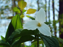
Our Spring Equinox hike this year will be in Ellison Park in the City of Rochester. This city park dates back to 1926, and covers 447 acres of city land. It has woodlands, steep slopes and the level flood plain of the Irondequoit Creek. There is one designated sledding hill and a non-motorized/car-top boat launch allowing boat access to Irondequoit Creek.  This plot of land encompasses much of the history of the locale before the city was built here. Fort Schuyler is a replica of the original Fort; Indian Landing was located on Irondequoit Creek and was used by the indigenous Iroquois as the beginning of the portage route which stretched along Ellison Park. The Lost City of Tryon, originally founded in hopes of creating a commercial settlement, used the Irondequoit Creek for trade. A store was built that bartered with the Seneca Indians, beginning Rochester’s trading roots.
You can print a copy of the park trail map here: EllisonParkMap (monroecounty.gov) The GPS coordinates of the lodge are 43.15107, -77.5133.
The Hike Meeting Place
From all points south:
1: Find you way onto the I-490 going north (that’s west in highway terms) towards Rochester
2: Use the right lane to take exit 21 for NY-590 N. Keep right at the fork, follow signs for State Route 590 N and merge onto NY-590 N
3: Take exit 6 for Blossom Rd. Turn right onto Blossom Rd
4: Ellison Park is bisected by Blossom Road; turn north onto Ellison Park Road and follow signs to Hazelwood Grove Lodge car park. Note; do not park in the dog park immediately off Blossom Road.
The Hikes
-Naturalists and Tourists will hike from Hazelwood Grove to The Pavilion round the hill, crossing Irondequoit Creek at the Indian Landing site. Visit the Fort Shuyler Trading Post and return via the service road along the creek to Hazelwood Grove.
-Climbers will cross Blossom Road then onto Rich’s Dugway Road to Coyote Trail. From Coyote trail we will take the Overlook Trail to the Overlook. On the return there will be the option of going up a beautiful gorge up to Penfield Road. From there we will return to Hazelwood Grove via the Coyote Trail.
Note; there is a very steep climb, half a mile into the hike. Poles are recommended. If it is icy, it would be good to have some extra traction on your boots.
The Social
Drive to Tryon City Tavern, 2300 Main Street, Rochester, for restorative sustenance and libations. The GPS coordinates of the tavern are (43.15946, -77.54940).
This is a change from the earlier published schedule. The Letchworth Park hike will be rescheduled for a Sunday later in the spring.
On Sunday the 26th, we will hike or bike on the Genesee Valley Greenway from Route 20 (a.k.a Telephone Road) north to the Erie-Attica Trail and beyond. The Greenway is a level and easy hike, about as well-drained a path as we will find at this time of year, and a new hike for some of us. The Greenway is a public multi-use trail following the route of the 19th century Genesee Valley Canal and the subsequent Pennsylvania Railroad’s Rochester Branch. It currently extends from Rochester to Cuba, NY, with plans for further extension to the south. It generally parallels the Genesee River on the west side. The Erie-Attica is a more recent rail trail including a trestle bridge across the Genesee.
Our meeting place is where the Greenway crosses Route 20, which splits away from Route 5 just west of the Village of Avon. There are Pedestrian Trail crossing signs, and ample parking is available on the north side of the road. All participants will head north, crossing Route 5 and going on to the intersection with the Erie-Attica Trail at 1 mile. Naturalists or anyone desiring a 2-mile hike can return to the start from this point. Tourists or those inclined to a medium length hike can head east on the Erie-Attica Trail for one mile to the Genesee River crossing on the old railroad bridge, then return to the start for a total of 4 miles. Climbers may choose to take in the Erie-Attic and then continue north on the Greenway as far as you choose before returning to the start. Any Cyclists may wish to ride north as far as the bridge and intersection of the Greenway with the Lehigh Valley Trail at 5.6 miles (13.2 miles with return) or all the way to Canawaugus Park in Scottsville and back for a 16.5 mile ride.
Showers are expected on and off for the later part of the week, but the trail is flat and firm, with a new layer of stone dust through most of it. The first mile has a grass and dirt surface.
Social – We will repair for restorative food and beverages at the 3-Legged Pig, 3415 Rochester Road, Lakeville, just north of the main intersection. See food menu at https://www.3leggedpig.com/menu. Beer is also available.
Directions – From Springwater and points south, take Route 15 north through Livonia and Lakeville to Route 5&20. Go west 3 miles on 5&20 through Avon to the point where Route 20 splits off to the left. Take Route 20 another mile to the Greenway crossing and start of hike. Parking on the north.
From points north and east, take Routes 5&20 heading west to Avon and beyond, forking left where Route 20 splits off from Route 5. In another mile you will come to the trailhead. Parking on the north. If you are coming on Route 390 from Monroe County, get off at Exit 10 and go west toward Avon, then left at the Route 20 split.
To the Social – Head back east on Route 20 and then Route 5&20 through Avon. Take Route 15 south to Lakeville. the 3Legged Pig will be on your left just before the main intersection with Route 20A at Lakeville.
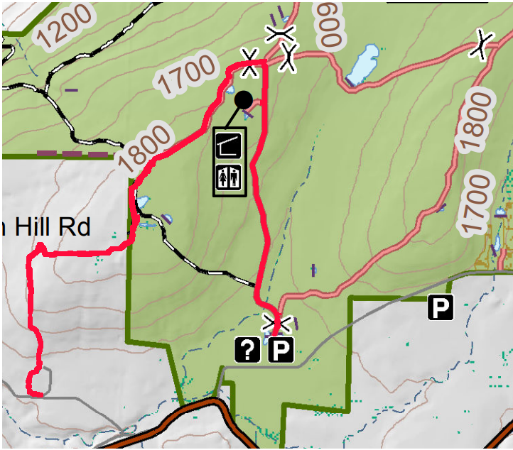
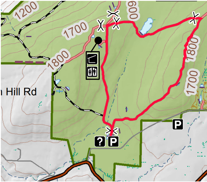
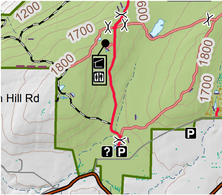
 Next Sunday’s hike will take us to this Wildlife Management area run by the DEC Division of Fish and Wildlife for the purposes of conservation and recreation. A “tor” is by definition a hill or mound, therefore not much flatland for hikers. However, I have done my best to accommodate our 3 levels of hikers for this outing.
Meeting Place Large parking area on Basset Rd. Naples. From Rt. 21 in Naples, heading south, bear left on Rt. 53.. In about .75 miles, turn left on County Rd. 21. aka Italy Valley Rd. Basset Rd is a left turn, about 2 miles east. The parking area is on the left, about .5 miles down.
Hiking Groups All hikers will start together on a gravel forest road which leads from the same point in the parking area. We will head north on the gravel road, soon passing through a gate and bear left and pass by two nice ponds, then head uphill on a gradual grade through the woods. When we reach the intersection where the orange trail (the Bristol Hills Branch of the FLT) enters from the left, hikers can split into separate routes.
The Climbers will turn left and follow the orange trail to the first intersection with the blue trail. At that point they will turn to the left to follow the blue trail down to East Hill Rd. Cars will be waiting to ferry climbers back to the Basset Rd parking lot.
The Tourists will turn right to follow the gravel road east to a gate, where they will turn right to head back down to the parking lot.
Meanwhile the Naturalists will continue straight on the gravel road. They may continue to the DEC lean to with an overlook of Canandaigua Lake. But the Naturalists should check their watches and turn about to arrive back at the parking lot at around 4:00.
Social Following the hike we will meet at Middletown Tavern on the corner of Main Street (Rt 21) and Clark St. (Co.Rd 36).
Directions: From the intersection of NY 21 and NY 53 at the south end of Main St in Naples, follow NY 53 south for 0.8 miles. Turn left onto Italy Valley Rd (CR 21). In 2.1 miles turn left onto Basset Rd. In 0.3 miles and after the road turns right, the parking lot will be on the left.
Directions to the social: Follow Basset Rd, Italy Valley Rd and NY 53 back to Naples. Continue straight onto NY 21 (Main St). The Middletown Tavern is on the left across from the gas station..
See you next Sunday.
The walk this Sunday will be a hike of our section of the Bristol Hills Branch of the Finger Lakes Trail in Naples. Springwater Trails has signed up with the FLT to maintain this part of the trail. This segment passes through the West Hill Preserve off Seman Rd and then across private land to Mt Pleasant Street in Naples. The Twisted Branch Trail Run comes over this section later in the year; a couple of hundred runners will be pounding the hill and we want to be sure the trail is safe and fun to run.
We will walk this stretch of the BHB and cut away any brush and weeds that have overgrown the path. The most useful tools for this are lopers and a small saw. There’s usually several large trees down after the winter; we’ll make a note of these and come back with a chain saw to clear them another day. Be sure to wear good work or gardening gloves. It’s a fairly long hike and steeply downhill at the Naples end of the walk.
The Climbers will walk all the way from Seman Road to the Village of Naples. This is a long walk of about 5 miles and is fairly steep coming down into the village, but the weather looks to be dry this weekend reducing the risk of slippery mud.
The Tourists will hike the section of the trail on Nature Conservancy land, turning around at the FLT sign-in box where the trails moves to private property. This is about 2.5 miles.
The Naturalists will follow the same trail at least as far as the wetlands, and as much more of the trail as they are comfortable with.
We will meet at the entrance to the West Hill Preserve on Seman Road (42.66166, -77.396288). We will shuttle some cars down to the hike end in Naples (42.625950, -77.397304) before we start.
Please note: Dogs are not allowed to hike on the Nature Conservancy property.
Another Note: When I last looked a couple of weeks ago there were several pieces of heavy equipment blocking the small parking area at the trailhead. If they are still there we’ll have to park along the road. Please park carefully and along one side only – the road is the minimum width a two-lane road can be.
The Social
The social with be at the Middletown Tavern at 183 S. Main Street in Naples.
Directions to the Hike Meeting Point:
From Springwater: Head south on NY 15 (for 5.2mi). At the light in Wayland turn left on NY 21N (for 6.7mi). In N Cohocton, turn left to stay on NY 21N (for 4.5mi). In Naples, turn left again to stay on NY 21N (for 1.8mi). On the north side of Naples, turn left on CR12 and head up the hill for 1.9 miles. Take the first left, Rhine St., to the 4 way intersection. Go left onto Seman Rd. Trailhead is about 1/2 mile, by a big sign on the left. Park along the road.
From Honeoye and Naples: Head south on CR 36 on the west side of Honeoye Lake (it’s 13.6 miles from NY 20A, and 1 mile from French Hill Road). Turn left onto Gulick Rd (for 2 mi), then right on Davis Rd (for 0.7mi). At the end of Davis, turn left on W Hollow Rd (CR 33) for 0.5mi, then right on Seman Rd. The Trailhead is about 1 mile, by a big sign on the right. Park along the road.
Directions to the social: From Seman Road, come down to Route 21 in the Village of Naples and turn right (that’s Main Street going South). The Middletown Tavern is on the left across from the gas station..
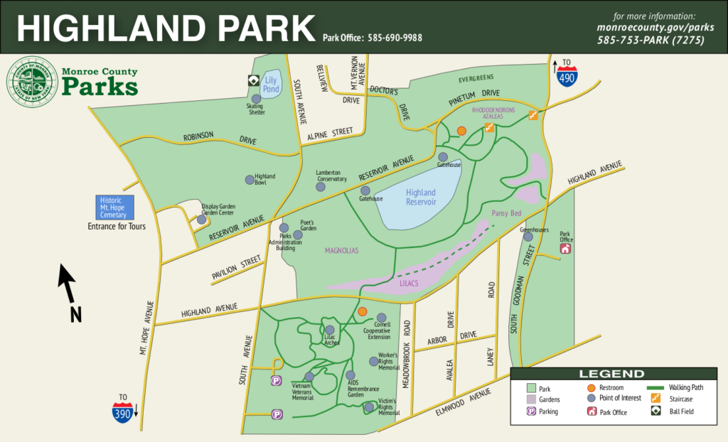 Spring is here and trees and flowers are blooming. Springwater Trails will explore Highland Park in Rochester, the site of Lilac Festival held on May 12-21, 2023. We likely will see many lilacs this early, but there should be plenty of other blossoms including daffodils and magnolias.
This hike will be on grass and sidewalks and will include various rolling hills. We will break into two groups and each group can adjust their route based on terrain and hiker’s interest.
The climbers will follow a 3 mile route reaching all corners of the park. We will start at the parking area in front of the castle (directions below). A short walk behind the castle will bring us to the Sunken Gardens. From there we will walk around the houses in the area and explore the park land between Reservoir Ave and Robinson Drive, passing above the Bowl and crossing South Avenue. From there we will head to the Poet’s Garden. I am planning to head across Highland Ave to see some of the various memorials that have been created. Returning to to lilacs, we will head for the Rhododendrons which bloom earlier than the lilacs, if I remember correctly. From there I plan to cross Pinetum Drive for a view over the city, and then make our way west, and explore north of Robinson Drive. to end up back at the cars. If time permits, we will cross Mt Hope and visit the Susan B. Anthony grave site.
The Tourist/Naturalists will follow the same route through the sunken gardens and around by the Bowl to the Magnolias. They will follow the sidewalk around the reservoir, down to the Pansy Bed, back up to the Azaleas and out to Reservoir Ave. The group can the decide whether to walk the sidewalk back to the cars (about 2 mi. total), or explore behind the Conservatory and continue back around the Bowl to the cars (about 2.5 miles).
Social: Following the hike, we will gather at The Distillery Restaurant 5 blocks south on Mt Hope Ave.
Directions:
From Springwater center: Head north on NY 15A toward Hemlock. Stay on 15A all the way to Rochester. After crossing the canal, continue straight across Westfall Rd, and then bear left to stay on East Henrietta Rd. Bear right onto Mt Hope Ave. Continue for about 3/4 mile, and turn right onto Reservoir Ave (first street after the light at Highland Ave). Take the first left into the park and park in front of the castle.:
From I-390 and points south and west: At the intersection with I-590, stay left to keep on I-390. Stay in the right lane and take Exit 16B to merge onto NY-15A. Continue straight across Westfall Rd, and then bear left to stay on East Henrietta Rd. Bear right onto Mt Hope Ave. Continue for about 3/4 mile, and turn right onto Reservoir Ave (first street after the light at Highland Ave). Take the first left into the park and park in front of the castle.:
From I-490, Victor and points south and east: Take I-490 west to Exit 17 (Goodman St). Turn left onto Goodman St and continue for 0.8 miles. At the top of the hill, turn right into the park on Pinetum Rd. Turn left then right onto Reservoir Ave. Cross South Ave and turn right into Castle Park. Park in front of the castle.:
On Sunday we will hike at the southern end of Letchworth State Park on the west side. People will meet and hike from the Inspiration Point parking lot.
A short description of the history of the site is contained in a plaque near the overlook.: “Inspiration Point is rich in history and natural splendor. The spectacular view here was once enjoyed by the Seneca Indians and by Mary Jemison, the “white woman of the Genesee”. In the early 1800’s, however, the pioneers valued the falls and forests for their power and utility, not their natural beauty. William P. Letchworth came to the valley in 1859 and began restoring the land. The state of New York accepted his gift of 1000 acres in 1907; and upon his death in 1910, Letchworth State Park was born.”
Climbers will do a loop of 4 miles following parts of the Gorge Trail, the Mary Jemison Trail, the Hemlock Trail and the Trout Pond Trail. This route has quite a few steps and some steep uphill and downhill sections.
Tourists and Naturalists will leave from the parking area and do a loop of several miles that will take in the Humphrey Nature Center, the Ant Trail, the Old School House and the Cemetery on Trout Pond Road. This walk is relatively flat.
Directions to Inspiration Point: If entering the park from the southern end, Inspiration Point is 1.7 miles from the Portageville entrance gate. If entering the from the northern end, Inspiration Point is 15 miles from the Mount Morris entrance gate.
Social: Letchworth Pines, 6985 State Route 19A, Portageville, Ny 14536.
Misc: There are restrooms available at Inspiration Point. Arrive in enough time to be ready to start hiking at 2PM. The weather report is calling for rain on Sunday so bring your rain gear! It is my understanding that entrance fees will not be charged until Monday May 1st.
People wishing to make a day of it may want to also go to a park program scheduled for earlier in the day: Mushroom & Moss Walk – Dishmill Creek Woods. Meeting at the Parade Grounds at 10AM, entrance on State Route 436, bring a lunch (3hours, 1 mile). For more information on that contact the Park directly.
 This Sunday, we’re returning to Sonyea State Forest in Livingston County, to hike along the Keshequa Creek. We will take time to enjoy the spring flowers.
We will meet at 2 PM at the gate that marks the head of the Keshequa Creek Falls Trail about 2.7 miles from the beginning of Union Corners Rd. See directions below. All hikers will walk around the gate to a well groomed trail the heads down a steep hill to the creek. Be careful walking down, and on the way back you will want to take your time climbing this hill. But the hill is not long and most of the rest of the trail is along the old Genesee Valley Canal and railroad bed. Our hike will take us to the western side of the forest, where we will encounter the gorge along Keshequa Creek. Within the gorge, we will see remains of the Genesee Canal and a major branch of the Pennsylvania Railroad, as well as rapids and falls along the creek.
The Naturalists will hike about a mile along the trail to a beautiful wide point in the creek where we can explore the falls and the intricate cracks in the rocks. After exploring that location, Katherine will lead the Naturalists back to the car the way we came.
The climbers will continue on the trail past the falls to the end of the trail, and then will return to the cars by way of the field to the entrance of the State Forest, and will walk on Union Corners Rd. If conditions or time require, we may adjust the route and return the way we came. Mark will lead the climbers..
![]() After the hike, we will enjoy the August weather with a picnic in the woods. Bring a dish to pass, or make a donation. We will select a clear area so, bring folding chairs, and a table, if you have one. There are no washroom facilities, not even portable ones, but lots of trees If the day should turn out to be a rainy one, we will return to the Sunrise, in Dansville.
After the hike, we will enjoy the August weather with a picnic in the woods. Bring a dish to pass, or make a donation. We will select a clear area so, bring folding chairs, and a table, if you have one. There are no washroom facilities, not even portable ones, but lots of trees If the day should turn out to be a rainy one, we will return to the Sunrise, in Dansville.
Directions: Please Note: Directions on Google Maps from Springwater takes you on NY 36 North to Craig Rd up through the Groveland Correctional Facility. This road is closed to cars, although walkers and bikers are allowed to use it as part of the Genesee Valley Greenway trail.. This is not a good way to get to our hike. Please follow the directions below.
From exit 6 on 390, turn south on NY 36. Then, take the first right onto CR 72, aka Presbyterian Rd. Follow it for 3.7 miles, bearing right at the intersection with CR 11, to Union Corners Rd. Turn right here and keep going for 2.7 miles,, till you see the gate. Union Corners Rd is unpaved, with potholes, making for slow going so, consider this in planning your travel time. Turn around at the gate and park on either side of the road.
From Springwater: Take NY 15 west from the flashing light. At the top of the hill (1.5 mi), turn left onto Liberty Pole Rd.(CR 38). Continue for 8.1 miles as the road number changes from CR 38 to CR 1A to CR 1. Turn left onto NY 63 S. In just 0.3 miles take the first right onto N 258. In 1.9 miles, continue straight across NY 36 and onto CR 72 (Presbyterian Rd). Follow the directions above to the state forest.
From Naples. Follow NY 21 S to Wayland. At the first light, turn left to stay on NY 21. In 1.8 miles south of Wayland, turn right on I-390 N. In 16 miles, take Exit 6. Turn right onto NY 36. Follow the directions above.
Looking for brochure.or mailing list so I can receive it in the mail.
Nothing opens up for mailing list.
There’s all kinds of very bizarre ads and post for viagra and other drugs above on calender page.
Please let me know if there’s a brochure available