
Hikes led by Springwater Trails are generally held on Sunday afternoons and appear in this calendar in green.
| Sun | Mon | Tue | Wed | Thu | Fri | Sat |
|---|---|---|---|---|---|---|
| A First Day Hike Along Canadice Lake 10:00 am A First Day Hike Along Canadice Lake @ Canadice North Parking Lot Jan 1 @ 10:00 am – 12:00 pm 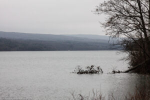 The Hike: Start the New Year the way you mean to go on – come for an inspiring hike along Canadice Lake! This is an easy, 1.8-mile hike along the shore of the lake; the trail is level and well-maintained … Continue reading | ||||||
| Harriet Hollister Spencer Park 2:00 pm Harriet Hollister Spencer Park @ Parking lot Jan 5 @ 2:00 pm – 4:00 pm 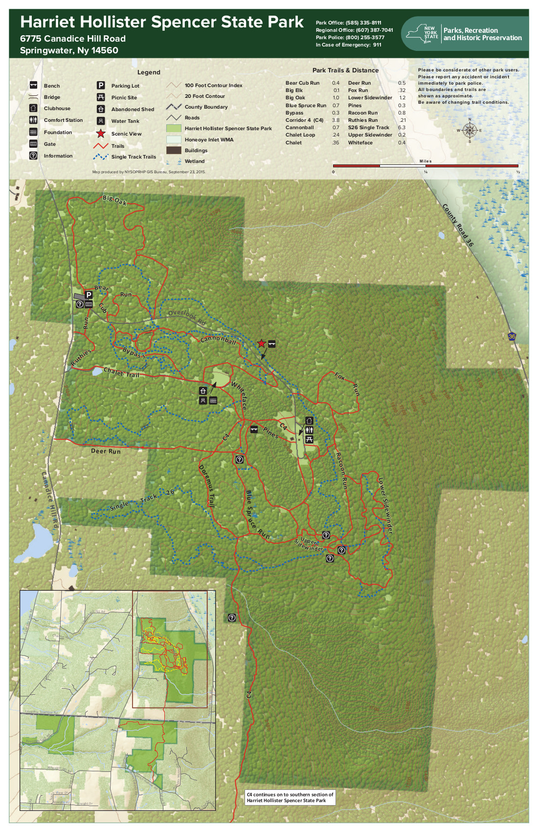 We will meet at the parking area at 2:00PM. All the snow has melted, so it might be muddy – be prepared! At this point, the prospect of snow shoeing or skiing is hopeless. It will be old-fashioned walking. Hikers may … Continue reading | ||||||
| Winterfest Hike at the Devil’s Bathtub, Mendon Ponds Park 2:00 pm Winterfest Hike at the Devil’s Bathtub, Mendon Ponds Park Jan 12 @ 2:00 pm – 4:00 pm 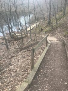 CANCELED. Both the Winterfest and the Springwater Hike scheduled for Sunday, January 12, 2020 have been CANCELED due to high winds and wet conditions. We will try to reschedule. Our mid-January hike will be at Mendon Ponds Park, coinciding with Monroe … Continue reading | ||||||
| Genesee Valley Greenway Series 2:00 pm Genesee Valley Greenway Series @ Greenway Parking Jan 19 @ 2:00 pm – 4:00 pm This Sunday Hike is a replacement for the Finger Lakes Trail series we have been doing this fall. The combination of the distance to the FLT and the winter weather has reduced the interest in this series. We may continue … Continue reading | ||||||
| Schribner Valley 2:00 pm Schribner Valley @ Hopkins Jan 26 @ 2:00 pm – 4:00 pm Last week we hiked on the Genesee Valley Greenway, a nearly flat and straight section of the old railroad bed. This week it is time for something completely different, as we will follow old farm and logging roads up and … Continue reading |
CANCELED. Both the Winterfest and the Springwater Hike scheduled for Sunday, January 12, 2020 have been CANCELED due to high winds and wet conditions. We will try to reschedule.
Our mid-January hike will be at Mendon Ponds Park, coinciding with Monroe County’s annual Winterfest. The park will be teeming with cold-weather fun activities between 11 and 3, including refreshments and programs on nature and winter sports for kids and adults. This time around we will hike the Devil’s Bathtub and West Esker parts of the park, as well as the popular Birdsong Trail near the Nature Center (good for chickadee-feeding).
We will meet at 1:45 at the Devil’s Bathtub parking area, a short drive inside the Pond Road entrance off Route 65/Clover Street, on the other side of the road from the Nature Center. If the upper Devil’s Bathtub lot is blocked off, park at the base of the hill and walk up. We will all begin by hiking down the stairs (with railings) and into the Tub, and then head north along a valley with a series of smaller kettle ponds and wetlands. The Tourists and Naturalists will peel off across the ridge and over to a trail along Deep Pond, passing the cars again after .6 miles, and heading south past the Bathtub and on to the Grasslands Trail, crossing Pond Road to loop around the Birdsong Trail and return, for a total of 2.6 miles. Climbers will venture farther up the Bathtub Valley and return on the ridge part of the West Esker Trail loop, continuing to the Grasslands and Birdsong Trail for a total of 3.8 miles.
Trail conditions are likely to be muddy due to rain in the prior few days, so poles and traction devices are recommended. Bring rain gear if the forecast is for rain between 2 and 4 Sunday.
Come earlier if you’d like to take advantage of the refreshments at the East and West Lodges, or the free coffee and hot chocolate and Wild Wings birds of prey at the Nature Center. Other free winter activities – dog sleds, orienteering, geocaching, winter equipment demonstrations, fossils and minerals, etc – are scheduled throughout the park; see https://www2.monroecounty.gov/parks-winterfest And here’s a park map link: map here
Social: Afterwards please join us for the social at the American Hotel at the center of Lima (7304 East Main St.. Lima), renowned for their huge selection of homemade soups as well as sandwiches, beverages and other hearty fare. You can see the full menu at https://americanhoteloflima.com/menu/
Directions: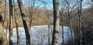
From Springwater: Head north on 15A for 21.6 miles through Hemlock and Lima. Take a right at the exit to Honeoye Falls. Stay on W Main St into the village where you will pass the Brewery Pub and Grill on the right at the intersection with NY 65 (1.9 mi). Continue straight onto NY 65 for 4.4 mi. (At 2 miles, you will go around a traffic circle. Stay on NY 65.) Turn right onto Pond Rd at the park entrance. The Devil’s Bathtub parking area is in .25 miles, on the left.
From Honeoye, take US 20A west and head north on CR 37 for 8.2 miles to W Bloomfield. Continue straight on NY 65 for about 3 miles, and make a right on Quaker Meeting House Road just before you come into Honeoye Falls. When Quaker Meeting House Road ends at Route 251 (Rush-Mendon Road), go left and then right on Route 65/Clover Street. The Pond Road entrance to the park is about 2 miles to the north, on the right. The Devil’s Bathtub parking area is in .25 miles, on the left.
From Rochester: Exit I 590 at Monroe Ave toward Pittsford. Turn right (south) onto NY 65 (Clover St). In about 6.7 you will come to the Canfield Road entrance to the park – this is not the one you want. Continue another 1.5 miles, then turn left onto Pond Rd, the second entrance into the park. The Devil’s Bathtub parking area is in .25 miles, on the left.
Directions to the Social: From the Devil’s Bathtub lot, go right back to Route 65/Clover Street. Make a left and go 4.4 miles to the village center of Honeoye Falls. Make a right on Main Street and continue about a mile out of town to the intersection with 15A. Make a left on 15A and proceed 2.3 miles to Lima. The American Hotel is at the intersection of Route 15A and Routes 5 & So (Main Street Lima). You can’t miss it.
This Sunday Hike is a replacement for the Finger Lakes Trail series we have been doing this fall. The combination of the distance to the FLT and the winter weather has reduced the interest in this series. We may continue later in the spring after seasonal roads reopen. But meanwhile, we are going to make an effort to visit sections of the Genesee Valley Greenway that Springwater Trails hasn’t seen. If there is snow, I am hoping this trail will be more appropriate than the FLT for easy cross country skiing.
In December, Wendy led a hike headed north from Cuylerville to Piffard. So this week we will continue north, starting in Piffard. If the snow listens to the weather man, we should have fresh snow Saturday and light snow Sunday afternoon. Check outside and bring your snowshoes, skis or winter boots.
All participants will start at the parking area in Piffard, and will head north toward York Landing Rd about 3 miles away. Skiers will turn around at York Landing and return to the starting point. Hikers and snowshoers will probably prefer to limit the distance to about 3 to 4 miles and therefore will end at York Landing where cars will be staged. (See below). Naturalists can watch the time and turn around to return to the cars if it is determined that conditions will not permit them to reach York Landing.
If you are willing to help stage cars, please arrive at the Piffard parking lot at 1:30 so we can shuttle cars to York Landing. Please send an email to info@springwatertrails.org so that I know who to expect.
Following the hike, we will head to the Yard of Ale to warm up with a pint and dinner.
Directions:
From Geneseo: Head north on Main St, then turn left on Court St, then at the bottom of the hill turn right on NY-63. In 2.3 miles, the road crosses the Greenway and parking is on the left next to the Yard of Ale. To get to York Landing Rd, continue west on NY-63 for 0.4 miles. Turn right on River Rd. Turn right on York Landing Rd in 2.7 miles. The parking is at the end of the road in 0.1 mile.
From Springwater: Take NY 15 north. After the curve at the top of the hill, turn left onto Liberty Pole Rd (CR 38). The road changes its name and number a couple of times, but keep going to the end. Turn right onto NY-63. Stay on NY-63 for 13.3 miles to Piffard. Parking is on the left next to the Yard of Ale.
From Wayland: Head south on NY 15/21 to I-390. Turn right onto I-390. Take exit 7 and turn right onto NY-408. Continue straight onto NY-63. Stay on NY 63 for 7 miles to Piffard. Parking is on the left next to the Yard of Ale.
From Honeoye: Head west on NY 20A. Turn right onto Big Tree Rd and continue for 6.9 miles into Livonia. Turn left on 20A and continue for 8.7 miles into Geneseo. Continue straight on Mary Jemison Dr by the college, then turn right onto NY 63. In 3 miles, parking is on the left next to the Yard of Ale.
Last week we hiked on the Genesee Valley Greenway, a nearly flat and straight section of the old railroad bed. This week it is time for something completely different, as we will follow old farm and logging roads up and down the valley south of Schribner Rd. As usual in the winter, the hikes will adjust to the weather but we are expecting there will be enough snow to enjoy cross country skiing, but also to allow a good hiking experience. So load up your car with your skis, your snowshoes and waterproof hiking boots and come enjoy the woods of Springwater.
NOTE: This hike will start at the intersection of two seasonal roads parts of which are closed in the winter. Please take a minute to read the directions below before trying to find your way.
There will be three hikes to choose from, based on the weather, and the wishes of the hikers.
Skiers: This route will take our skiers to both sides of the valley to enjoy the paths along the various forests of the area. You will see a hardwood forest on the steeper slopes which was logged about five years ago, plus several different evergreen forests planted in the 50’s. Most of the route will be along the contours, but expect a few steeper sections. We won’t nail our skies to our boots, so taking them off when the path is too step will be an option for everyone. Expect about 5 miles of skiing.
Tourists: Linda will lead the Tourists and Climbers along the creeks (these creeks flow south to the Cohocton River and to the Chesapeake Bay) and up the hill through the woods. Winter is a great time to explore areas that are too wet in the summer and to see landscape that is hidden behind natural greenery in warmer months, so this hike may take you places you haven’t been. Expect a good 3.5 mile winter hike.
Naturalists: And best of all, Katherine has agreed to lead the Naturalists on a loop around the near side of the valley. Come enjoy views from high above the creeks, look for the many types of trees from White to Red Pine, Norway Spruce, Scotch Pine and Larch trees. You can also see Black Cherry, Oak and Maple, Apple and Poplar. Katherine will point out the Red Pine woods planted in the 30s by the Teed family, and the Larch and Red Pine woods planted in the 60s by the Barnes cousins – both were 4-H projects. This route will take you around two ponds and near the Mushroom farm – just speak up if you miss the mushroom logs.
Following the hikes, please join us for a dish-to-pass social at the house. Linda is promising tacos.
Directions: Do not enter either Schribner Rd or Giles Rd from Strutt St (the west end). You must come into Schribner Rd from Tabors Corners Rd on the east side. If you use a GPS, set it for the intersection of Tabors Corners and Schribner. The follow Schribner for exactly one mile to the driveway on the left at the intersection of Schribner and Giles. Thanks to the Springwater Highway Department, you will find street signs at each of these intersections!
The final address is 8664 Schribner Rd. The sign a the end of the driveway says Hopkins and the mailbox says 8664. You are welcome to park in the driveway right up to the garage or out on the road. It is recommended that you head your car out as you park during the daylight.
From Wayland and points west: From the intersection of NY 15, 63 and 21 in Wayland, take NY-21 N east for 3.0 miles. Turn left at the sign for Bowles Corners (maps show this is Tabors Corners Rd). In 2.0 miles turn left onto Schribner Rd. In 1.0 miles the driveway is on the left.
From North Cohocton and points east: From the intersection of NY 21 from Naples, and NY 371 from Cohocton, head west on NY 21S for 3.8 miles. Turn right at the sign for Bowles Corners (maps show this is Tabors Corners Rd). In 2.0 miles turn left onto Schribner Rd. In 1.0 miles the driveway is on the left.
From points north: Take Wheaton Hill Rd up from NY 15A, or Tibbals Rd from Ontario County 37, up to Wetmore Rd in Springwater. Turn south on Wetmore, up over the hill to a stop sign at Tabors Corners Rd. Turn right onto Tabors Corners Rd for 3.5 miles. Turn right onto Schribner Rd. In 1.0 miles the driveway is on the left.
If you get lost, call 678-1757 and tells us the last road sign you saw!
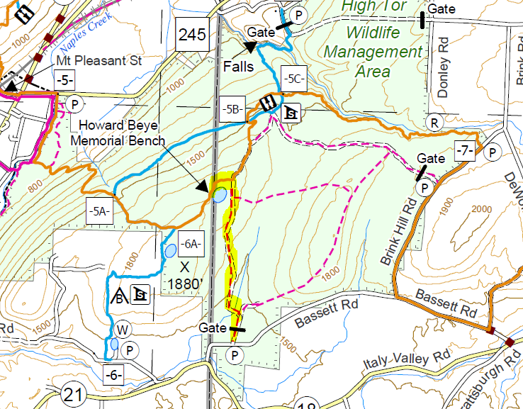 Sunday’s hike will follow trails on the top side of High Tor Wildlife Management Area in Naples.There are many trails within High Tor ranging from the Bristol Hills Branch (orange) of the FLT, to maintenance roads (dashed red) maintained by DEC. Between are the Blue Trail (blue) which crosses the BHB, and several other interesting trails (gray). This hike will stay up top on trails appropriate for boots, snowshoes or skis (depending on the snow conditions!).
We will all meet at the DEC parking area on Basset Rd near the west end of the road (See the map to the right). Please arrive in time to get your preferred equipment on in order to start the hike at 2:00 PM. We will have three hikes based on distance. Hike leaders may adjust the hikes to accommodate our hikers and the weather. Please note: in the following hike descriptions, the term road refers to the maintenance road, which is more accurately called a wide trail.
All hikers will start on the same trail out of the parking area. The Naturalists will take the left route and follow the maintenance road up to the BHB trail. Turniing left onto the BHB (orange blazes) they will quickly come to the pond and will explore the shore of that. Returning on the BHB to the maintenance road, the Naturalists will follow their own footsteps back to the cars.
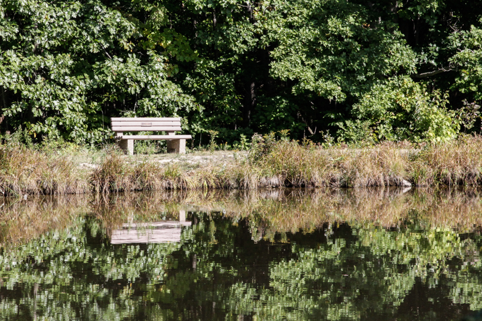
The Finger Lakes Trail from Naples to Parrish Gully. The Howard Beye memorial bench.
The Tourists will go to the right and follow the roads counter-clockwise (turn left at intersections). When they meet the road that the Naturalists came up, the BHB will be to the right. If time permits they can turn right and follow the road (the BHB follows the road most of the way, but breaks off into the woods before the overlook) to the lean-to and overlook of Canandaigua Lake. Returning on the road, they will retrace their steps to the point where the BHB turns right. The tourists will continue straight (not on the BHB) south to the cars. They will likely meet up with the Naturalist on the final leg and will then return together to the cars.
The Climbers will carpool to the East Hill Rd entrance to the Blue Trail. This property is part of the FLCC and there is a nice parking area just off East Hill Rd for us to park. The Trail starts at the corner of the driveway and the road and heads across the field to the woods and the up along the edge of the woods. There is also a ski trail that takes the diagonal across the field, in case anyone wishes to bring their skis. Most parts of the trail have an inch of snow, enough for skiing, but there was some ice and wet ice that may bother skis. Unless we get another 2 inches before Sunday, I am not planning to ski. The trail is well marked once it gets into the woods, and even if you take the ski route which seems to chris-cross the blue trail with slightly longer switchbacks, they all come out at the same spot at the edge of the High Tor WMA. Turn left to stay on the blue trail around a small pond. The intersection with the BHB (orange blazes) is well marked. Turn right onto the orange trail. We will go by the Howard Beye memorial bench and then join up with maintenance trails. The overlook is to the left, and the cars at Basset Rd are to the right.
Following the hike, we will meet to socialize, warm up and eat at the Redwood Inn. (Return to Naples, and turn left on NY 21. The Inn is on the left.
From Naples: Take NY 53 south from Naples for 1.1 miles. Turn left onto Italy Valley Rd (CR 21) for 2.1 miles. Turn left onto Basset Rd, when the main road takes a sharp right turn. Parking is on the left in 0.2 miles.
Additional directions are available here.
The Genesee Valley Greenway is asking for ideas on needed enhancements along the Greenway. This will be an open workshop aimed to hear your suggestions for the park and how it might improve your communities. There is a series of two open workshops, with the first on February 7th in Cuba NY. Please check the Friends of the Genesee Valley Greenway for more information.
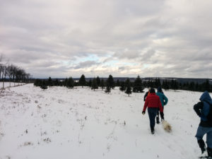 You are invited to hike on private land near the Northwestern corner of Springwater on the 245 acre All Western Evergreen Nursery & Christmas Tree Farm owned by Katherine Humphrey and daughter, Jerrianne Scheiderich. The entrance to the farm is at 6840 Liberty Pole Road (County Road 38, 1 mile from State Route 15 between Springwater and Webster’s Crossing). It is well marked and is on the South side of the road. There is ample parking behind the house where the wholesale trees are loaded out. The hike this Sunday, February 9th will begin shortly before 2 PM. Arrive early for instructions regarding routes for the three skill levels: Climbers, Tourists, and Naturalists. Katherine will have maps of the plantations for the volunteer leaders to aid in hike path directions, which can be modified by the leader as desired.
On the hike, expect winter conditions. If there is enough snow, skis and snow shoes can be used. Wear winter hiking apparel and bring water, walking sticks, and snacks, as desired. Beware of stones, woodchuck holes, boughs laying on the ground, and stumps. Leashed or unleashed dogs that mind their masters are welcome too! We will crisscross the farm from behind the residence to Story Road, Swartz Road, and/or Liberty Pole Road. The nursery beds and several exotic trees are near the residence and on the way up through the woods. There is a leisurely incline of from 1200 to about 2000 feet. The tree farm was started in 1968, making 2020 the 52nd year of planting trees. Participants may like to notice the many different species of Christmas trees planted and compete in an ID quiz in the shop at the end of the hike.
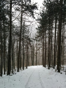 Crossing the farm from one end to the other will encompass as many miles as the number of times anyone wants to crisscross, as it is at least 1 mile from road to road. The roads that surround the farm are Liberty Pole Road, Story Road, Swartz Road, and Carney Hollow Road. You will find hardwoods, a red pine forest (cathedral pines planted over 75 years ago), Christmas tree plantations (some with solar powered electrified fences that are turned off for the hike) with field roads traversing the land, and rented open tillable fields last planted to winter wheat or mowed as they are in the USDA Conservation Reserve Program due to the steep lay of land and need to keep 2 feet of top soil from eroding.
The after hike social will be at the farm residence where a dish-to-pass social will be anchored by delicious home-farm prepared soups. If you wish, bring food/beverage as refrigeration and ranges are available for keeping items cold or hot. For those who would like to know more about Christmas tree farming, Katherine is willing to share tree culturing and marketing techniques used at this farm.
Directions: If using GPS, use address of 6840 Liberty Pole Road, Dansville, NY 14437 so you do not end up in the middle of one of the fields and call 585-669-2659 or 585-737-5205 for directions if you get lost.
From Springwater at the blinking light and intersection of 15A and 15, take 15 North to County Road 38 (Liberty Pole Road), the second left (West). Stay on Liberty Pole Road for almost a mile. The farm will be the third residence on the high side of Liberty Pole Road after you cross Carney Hollow Road intersection. Please follow the orange cones in the driveway to the parking area behind the residence facing the Liberty Pole Road so as to easily pull out after dark, unless a handicapped spot is needed near the people door to the shop that says “Welcome, Come In”, which is the preferred door to enter the residence.
Check here for additional directions to the hike.
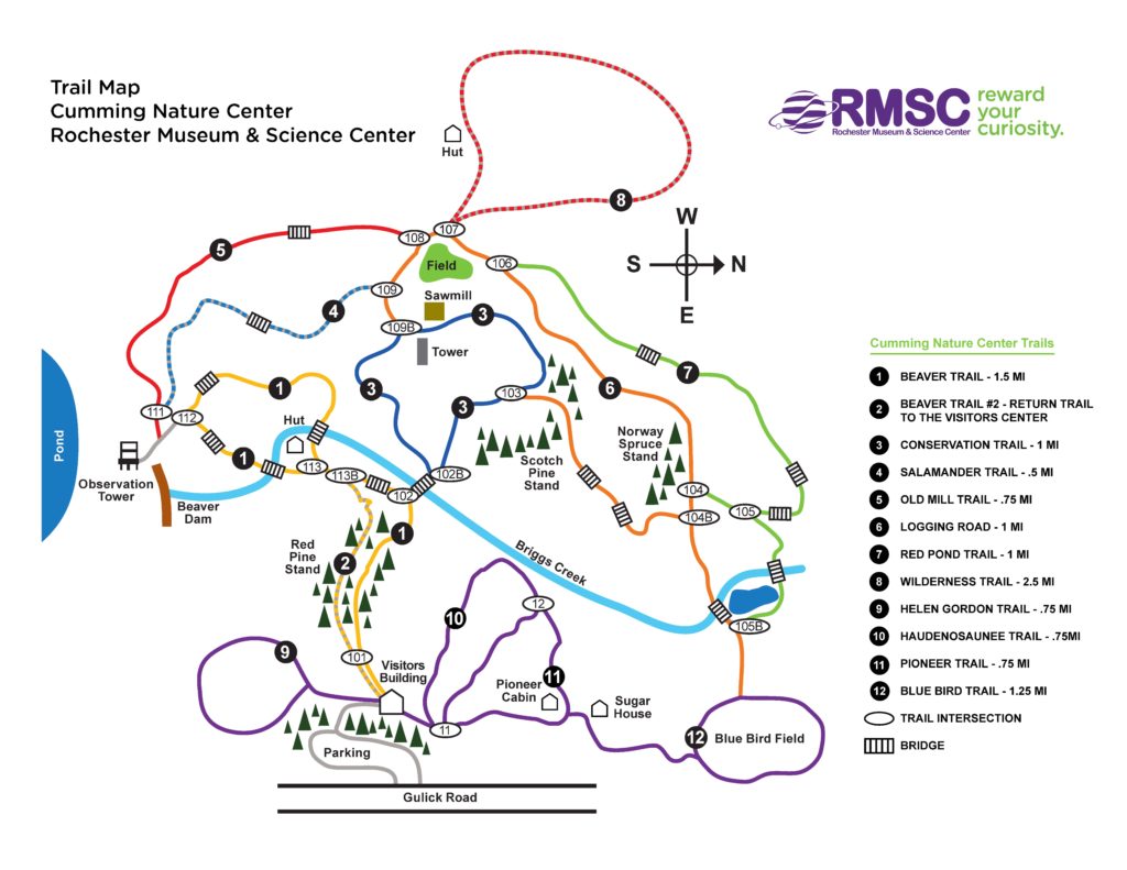
On Feb 16 we will visit Cumming Nature Center in the hills above Naples NY for hiking/skiing/snowshoeing, depending on conditions. We’ll be hiking the day after the Nordic Festival ends, so unless there’s a fresh fall of snow in the night, the hiking, skiing and snow shoeing trails will be well groomed and trodden down.
If conditions permit, skis and snowshoes will be available for rental ($15), or bring your own. If you have extras, bring them to share. Whatever your mode of travel, dress warmly with good traction footwear, poles, layers and water.
Cumming is a branch of Rochester Museum and Science Center. If you are not a member of RMSC, there is a small fee for access to the Center. Group fees have been paid by SWT, so just identify yourself, at the desk, as part of Springwater Trails Hiking Group.
Our treks will begin at 2 PM.
Social – There’s a choice of socials this time. Those who choose to can go for an English High Tea at Another World B&B; those who prefer our traditional style of social can gather at the Neapolitan Pizzeria in Naples.
A “High Tea” is a sit-down affair with plenty of cakes, pastries, other fancy foods, and of course tea, all served on the host’s finest china. Coffee can be provided for those who really don’t like tea, though people will talk about those who do when they have departed. The cost is $22/person inclusive of everything – probably what we each usually shell out for the social after all the tips and taxes that pad restaurant bills these days. The hosts accept only cash for the High Tea and they won’t complain about us wearing hiking gear.
Another World B&B is at 8404 French Hill Road in Naples.From Cummings, go south on Gulick Road (that’s RIGHT as you exit the Cummings parking lot) and keep going until Gulick Road ends at Ontario County Road 36. Turn right, going up the hill towards Honoeye; then after about a mile or so turn left on French Hill Road. Another World is a mile up this road on the right hand side, and it has a large clear sign announcing it.
The Neapolitan Pizzeria is at 120 N. Main Street in Naples. From Cummings, go south on Gulick Road (that’s RIGHT as you exit the Cummings parking lot) and keep going until Gulick Road ends at Ontario County Road 36. Turn LEFT, going down the hill towards Naples. County Road 36 ends at State Route 21, which also Naples Main Street. Turn left, and the pizzeria is about half a mile along the road on the left hand side.
Directions to the Hike Trail Head
From Rochester and points North: Take 390 South to Routes 5 & 20, Proceed to Rt15A in Lima. Head South on Rt15A to Route 20A in Hemlock, Head East on 20A to East lake Road in Honeoye. Proceed South on East Lake Road to County Road 33, (there are signs pointing the way from the junction of East Lake Road and County Road 33). Turn East on County Road 33, then Southwest on Pinewood Hill Road. This becomes Gulick Road. After 4.7 miles the CNC entrance will be on the right
From Springwater: Go North on Rt 15A to Route 20A in Hemlock, Head East on Rt 20A to East Lake Road in Honeoye. Proceed South on East Lake Road to County Road 33 (Signs point the way from the junction of East Lake Road and County Road 33). Turn East on County Road 33, then Southeast on Pinewood Hill Road. This becomes Gulick Road. After 4.7 miles the CNC entrance will be on the Right.
From Wayland, Naples, and points South: Follow NY 21 East from Wayland,thru N.Cohocton to Naples (11.4miles). Turn Left onto Clark Street (County Hwy36), heading North (Next to Middletown Tavern). Take first Right onto Gulick Road. Follow Gulick Road for 6.6 miles. CNC will be on the Left.
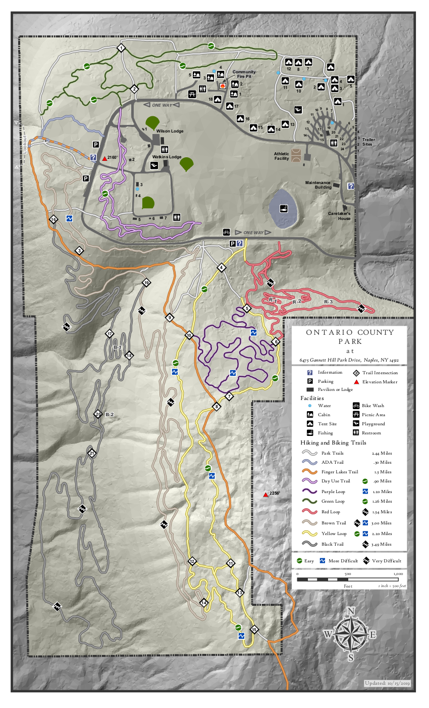
As you know, last month we switched the FLT series to the Genesee Valley Greenway series for the opportunity to ski and snowshoe on the level Greenway. Three of us had a very nice ski and the others hiked. Since this hike was planned for February, I expected the snow to be even better, but the weather isn’t cooperating. So, let’s go to higher country and see what Ontario County Park is like.
Ontario County Park provides hiking, biking, cross country skiing, fishing (no hunting), and camping or picnicking opportunities depending on the season. So bring your skis, your snowshoes and your hiking boots and we will have maps so you can select from the many trails.
Here are our recommendations for Sunday.
The Climbers will follow the Bristol Hills Branch of the FLT to junction 9 where they will turn right onto the Brown bike trail. Following that trail south and returning to junction 19, where they can pick up the Black trail and follow that to junction 20 and then back north to 17 and 16 and back to the cars.
The Tourists and Naturalists will also follow the Bristol Hills Branch past junction 9 to junction 10. Then turn right to follow the yellow trail through junctions 12, 14, 15, 13, 11 8, 7, 6 5, 4 and to the road. Crossing the road will allow this group to explore the fields and return on the Day Trail around the shelters to the cars.
Following our hike, all interested hikers will gather at the Neapolitan in Naples for Pizza or hot sandwiches. The Neapolitan is located on the west side of Main St one block south of the high school.
Directions: The easiest route is to take NY 64 to Bristol Springs and turn west on Gannett Hill Rd. There is a sign indicating Ontario County Park. At the top of the hill turn right onto South Gannett Hill Road. The park entrance is straight ahead. Follow the park road for about .5 miles to our meeting place which is the parking area along the park road near the information kiosk at the Finger Lakes Trail trail-head.
Update on trail conditions, Saturday 2-29: The trail we will follow has a base of 1-3 inches of packed snow and 3-5 inches of fresh powder on top – excellent conditions for boots, snow  shoes and XC skis. The first half of the hike will be on trails which have been partly packed down by snowmobiles. For the second half in the Climber hike, there is some road walking and some hiking through untrodden snow. Snowshoes will make the walking easier in some places, but you may want to remove them for other parts. but it’s all OK with just boots. The end of the hike is a c. 200 foot slope down through a field – perfect for ski enthusiasts.
This Sunday we will explore the woods and fields overlooking Honeoye Lake on the west side, followed by a dish-to-pass social at the Affolter farm. Meet at 1:45 at 5422 County Road 37, about 2 miles south of Route 20A and 2 miles north of Canadice Town Hall. Park in the drive or on the road shoulder. Our hikes will take us up the ridge, through wooded trails and along gully rims. Get a scenic vista of the whole expanse of Honeoye Lake, from a new and different perspective.
Climbers will head northwest from County Road 37 through the woods toward Howcroft Road to make a loop of about 3 miles. Tourists and Naturalists will start out on the same route, but with a slower pace on the initial uphill climb, and will complete a smaller loop of about 2.5 miles. Hiking conditions are good; skis, snowshoes, and boots will all work.
Social: Bring your favorite goodies along for our social at 5422 County Road 37.
Directions:
From Springwater, take Route 15A north 2.7 miles to a right on Johnson Hill Road. In 1.1 miles, make a left on County Road 37. Continue northeast for 6.7 miles, including a turn to the left after Canadice Town Hall. #5422 will be on your left, just before you leave the town of Canadice and about a half mile after you pass Hayward Hill Road and Jersey Hill Road. Driveway has a large red barn and silo to the north.
From Honeoye/Hemlock: Take Route 20A east from Hemlock or west from Honeoye to the intersection with County Road 37. Go south approximately 1.9 miles. #5422 will be on the right, with a red barn and white silo, just past the Entering Town of Canadice sign.
Over the years we have enjoyed many hikes in the hills and ravines surrounding the Village of Naples; this Sunday we will take a tour of historical sites in the village. Town Historian John Murphy has kindly agreed to be our guide. We will meet at 2pm in the municipal parking lot behind the buildings on the west side of Main Street. Nearby are the Historical Society’s Morgan Hose Building and the Old Mill. We will move to Main Street and then north past the Maxfield Inn, Memorial Town Hall and on to the Cleveland House at the end of the village. The Hose Building and the 1794 Cleveland House will be open. Also, we can visit other sites such as the Indian and Pioneer burial ground.
People can either walk or car pool to the various stops along the way – it will be several miles round trip. In addition to dressing for the weather, if it looks like rain – you may want to have an umbrella with you. Don’t forget that daylight savings time begins on Sunday.
Our after hike social will be at The Hollerhorn Distillery, 8443 Spirit Run, Naples, NY 14512.
Directions
From Springwater, Wayland and Dansville: Take NY 15 S or NY 63 S to Wayland. From Wayland, head east on NY 21 N through N. Cohocton to Naples. Turn left on S Main St (Naples) to stay on NY 21 at Wilcox Lumber. In 0.6 miles turn left onto Mill St just past the Naples Hotel. The parking lot is behind the Hotel on your right.
From Canandaigua: Take NY 21 S to Naples. After the High School, take the third left onto Mill St. The parking lot is behind the Naples Hotel on your right.
Looking for brochure.or mailing list so I can receive it in the mail.
Nothing opens up for mailing list.
There’s all kinds of very bizarre ads and post for viagra and other drugs above on calender page.
Please let me know if there’s a brochure available