Hikes led by Springwater Trails are generally held on Sunday afternoons and appear in this calendar in green.
- Categories
- Tags Barry Childs and Kathy Cloonan barry@africabridge Bike Bill Cooke Bob and Cindy Wagner Bob Menz (bert6952@yahoo.com) Bristol Hills Branch CANCELED Clarks Gully CLWA Colorado Trail Dog friendly Finger Lakes Trail FL FLT Gene & Georgia Binder (585) 236-5384 Gene and Georgia Binder (585) 236-5384 Greenway Gully Gypsy moth Hemlock Hike John L Katherine Humphrey? Kayak Landowner Liability Leader: Mark Lehigh Valley Trail Mark and Laure Allen (585) 662-9305 Mark and Linda Mary Ann Devey (315) 573-0774 Mary Lou Wenthe (585) 208-4337 Melissa Mitchellsville mjkcloonan@frontiernet.net Mushroom Foray Naples Nunda POSTPONED Rick Henchen Saralinda Saralinda Hooker Schribner Scott Sevensma (585) 413-8461 Sharon Boldt (boldtbs@yahoo.com) sugarbush hollow Summer Weekly Wendy Stevenson
| Sun | Mon | Tue | Wed | Thu | Fri | Sat |
|---|---|---|---|---|---|---|
| Italy Valley to Italy Hill on the Finger Lakes Trail 4:00 pm Italy Valley to Italy Hill on the Finger Lakes Trail @ Italy Valley FLT Parking Area Jun 2 @ 4:00 pm – 6:00 pm Italy Valley to Italy Hill MAP Note as of June 1: This is a revised hike plan to avoid rough and boggy conditions at the top section of the trail. Meeting location and Social location remain the same. Two winters … Continue reading → | ||||||
| Middlesex Valley Rail Trail 4:00 pm Middlesex Valley Rail Trail @ Parrish Rd Parking Lot Jun 9 @ 4:00 pm – 6:00 pm  This Sunday we will hike the Middlesex Valley Rail Trail, which runs northeast from Naples, passing through the lowlands of the Hi Tor Wildlife Management Area. The 7.2 mile rail trail is parallel to Route 245, and follows alongside of … Continue reading → | ||||||
| FLT Letchworth Branch Series – Portageville == CANCELED 4:00 pm FLT Letchworth Branch Series – Portageville == CANCELED @ Greenway Trail Head Jun 16 @ 4:00 pm – 6:00 pm 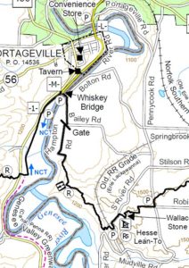 Rain, Father’s Day, busy week – All adds up to canceling today’s hike. Sorry for the inconvenience: Today’s Hike is Canceled! Join us next Sunday. Happy Father’s Day. Please join Springwater Trails for a hike along the Genesee … Continue reading → | ||||||
| CHANGE OF VENUE: Onanda Park Stream Hike, plus optional bike ride or Quiet Meadows 4:00 pm CHANGE OF VENUE: Onanda Park Stream Hike, plus optional bike ride or Quiet Meadows @ Onanda Park on Canandaigua Jun 23 @ 4:00 pm – 6:00 pm 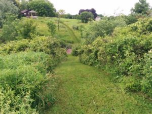 For our June 23 event hike we will revisit Onanda Park, on the west shore of Canandaigua Lake (4965 County Road 16), for the summer solstice experience – hikes in the woods and in the streambed, with a West Lake … Continue reading → | ||||||
| Hemlock Lake Paddle and Rob’s Trail Hike 4:00 pm Hemlock Lake Paddle and Rob’s Trail Hike @ Hemlock Lake North Boat Launch Jun 30 @ 4:00 pm – 6:00 pm This week we will have 4 groups. All will meet at the parking area near the North boat launch at 4:00. Paddlers are asked to arrive about 20 minutes early to have time to ready their boats for a 4:00 … Continue reading → |
-
Categories
-
Tags
Barry Childs and Kathy Cloonan barry@africabridge Bike Bill Cooke Bob and Cindy Wagner Bob Menz (bert6952@yahoo.com) Bristol Hills Branch CANCELED Clarks Gully CLWA Colorado Trail Dog friendly Finger Lakes Trail FL FLT Gene & Georgia Binder (585) 236-5384 Gene and Georgia Binder (585) 236-5384 Greenway Gully Gypsy moth Hemlock Hike John L Katherine Humphrey? Kayak Landowner Liability Leader: Mark Lehigh Valley Trail Mark and Laure Allen (585) 662-9305 Mark and Linda Mary Ann Devey (315) 573-0774 Mary Lou Wenthe (585) 208-4337 Melissa Mitchellsville mjkcloonan@frontiernet.net Mushroom Foray Naples Nunda POSTPONED Rick Henchen Saralinda Saralinda Hooker Schribner Scott Sevensma (585) 413-8461 Sharon Boldt (boldtbs@yahoo.com) sugarbush hollow Summer Weekly Wendy Stevenson
 Rain, Father’s Day, busy week – All adds up to canceling today’s hike. Sorry for the inconvenience:
Today’s Hike is Canceled! Join us next Sunday.
Happy Father’s Day. Please join Springwater Trails for a hike along the Genesee River. Bring your father or your grandson and enjoy the views. Because of Father’s Day, please leave a message if you are planning to hike with us. Please check the website the day of the hike – We will cancel at 1:00, if no one plans to hike. Thanks.
This week will mark the end of the Springwater Trails Letchworth Series and the start of a new series showing off the main Finger Lakes Trail between the Letchworth and Bristol Hills branches. Our Letchworth Series was plagued with weather and water, so we will be leaving Letchworth with a few sections undone. But it is time to move on.
This hike will start in the town of Portageville south of the Letchworth Park. We start on a portion of the trail which is shared with the Genesee Valley Greenway and will end on a section that is shared with the North Country Trail. We can dedicate this hike to continued cooperation between hikers and hiking groups.
All hikers will meet in Portageville south of the bridge on NY 436 across the Genesee River. NY 436 turns right in the center of Portageville but the trailhead is straight ahead about 100 feet up Main St (south of the Hotel).
The first section of the hike follows the old railroad bed, cutting across a loop in the river for a mile.The Naturalists will continue under the Whiskey Bridge and south along River Rd (a little used section of dirt road) to NY 19A, where they will take a sharp right turn onto the main Finger Lakes Trail and hike back to the Whiskey Bridge. After a short exploration of the bridge itself, the Naturalists will return to the west side of the Bridge and scramble down a steep connection to the right back to the branch trail. Turning left, they will retrace the branch trail to Portageville.
Meanwhile the Tourists and Climbers will leave Portageville on the branch trail. When they come to the Whiskey Bridge, they will turn right to climb up to the entrance to the bridge and the main trail. After crossing the river, the trail continues along dirt roads to a nice view of the river, for about 3 miles to a parking area on S River Rd, where we will have a car waiting to return to Portageville.
Following the hike, join us for a social at the Sunrise Restaurant in Dansville.
Directions:
From Springwater, Wayland and Dansville: Take 15 S to Wayland. Turn right and follow NY 63N to Dansville. Turn left on NY 36N (Ossian St). In half a mile, stay straight onto NY-436W (Ossian St). Continue through Nunda and past the entrance to Letchworth. At the bottom of the hill you will cross the Genesee River into Portageville. At the cross-street Hamilton St, (the Genesee Falls Inn is on the left), continue straight as 436 turns right. The Letchworth Branch Trail enters the woods on the left.
From Honeoye and Hemlock: Take NY 20A west through Livonia and Lakeville. Turn left onto the ramp for 390S. Take the next exit for NY 408S. Stay on 408 through Mt Morris into Nunda. Turn right at the light on NY 436W. Go past the entrance to Letchworth. At the bottom of the hill you will cross the Genesee River into Portageville. At the cross-street Hamilton St, (the Genesee Falls Inn is on the left), continue straight as 436 turns right. The Letchworth Branch Trail enters the woods on the left.
Directions to the Social: Follow 436E back through Nunda to Dansville. Continue straight onto NY-36. Turn left on Main St. The restaurant is on the right with parking on the street or in the rear.
For our June 23 event hike we will revisit Onanda Park, on the west shore of Canandaigua Lake (4965 County Road 16), for the summer solstice experience – hikes in the woods and in the streambed, with a West Lake Road cycling option and an optional side trip to the nearby Quiet Meadows wildlife and meditation sanctuary.
Meet at the parking lot on the west (Uplands) side of County Road 16 (a.k.a West Lake Road) at 3:45. We will divide into three groups: Cyclists, Naturalists/Meditators, and Wet Feet Hikers. Cyclists and Naturalists/Meditators may time their activities so that they get in some wet feet hiking during the second half of the event.
Cyclists will head north on West Lake Road for approximately 5.25 miles to the Yacht Club, then return, for a total of 10.5 miles, or choose a longer route if they wish. West Lake Road is a good cycling route, with paved shoulders averaging 4′ and a 35 MPH speed limit. There are two moderate climbs each way, but much of the route is at lake level. After returning to the starting point, Cyclists may cool off with a hike up the creekbed and back (bring a change of shoes).

Naturalists/Meditators will car pool about 1.1 miles to The Quiet Meadows, at 5787 Barnes Road. The Quiet Meadows is a Certified Wildlife Habitat and a private outdoor sanctuary for meditation. It is not a recreation site, but is intended for quiet contemplation and appreciation of nature. The 5 acre property includes a grass labrynth and a network of mowed grass paths and bridges through shrubs, grasslands and wetlands. As the owners explain at their web site, “visitors are encouraged to walk the paths and the labrynth, sit on the benches for quiet repose, prayer and reflection and take away with you some of the stillness of the hills.” This is a particularly beautiful time of year in the meadows, with many wildflowers and flowering shrubs in bloom. You may want to revisit this site many times for its outstanding sense of peace. See https://www.quietmeadows.org/about.html for more about Quiet Meadows and the tradition of the labrynth. After the session at the Quiet Meadows, the Naturalists/Meditators will return to Onanda Park to cool down with a short hike up the creekbed (bring a change of shoes).
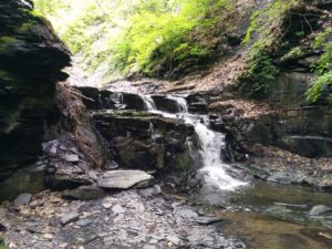
Climbers, a.k.a. Wet Feet Hikers, will explore a different section of Onanda Park from the trails we saw in the snow last March. We will start off on the South Rim Trail (about .75 miles), then head up the creekbed of Barnes Gully and back, passing through the culvert under West Lake Road and down to the mouth of the creek at the lake for some stone skipping. The creek hike is not a town-sanctioned trail, but walking in it is not prohibited, and there are well traveled paths along one side or the other across most of the length. Getting between them requires going through the stream, so expect to get your feet wet. Water sandals or old sneakers with good treads are recommended. The water level will be up to ankle height in most places. We will encounter a series of waterfalls of increasing difficulty, and will keep going until we reach the chicken-out point. Estimated creekbed hiking distance, including the trip to the lakeshore and back, is about 2.5 miles.
Social – Please join us for a dish-to-pass social in a lakeview pavilion close to the parking area.
Directions: from Springwater: Take Route 15 south to Wayland and Route 21 east/north to Naples. Continue through Naples and Woodville. 2.75 north of Woodville, take a right to follow Route 21 north where it splits with 64. Go another 4.9 miles, then make a right on County Road 16 (a.k.a West Lake Road). Enjoy the panoramic view of the lake. In 2 miles you will be down near the lake shore. Make a left into the “Uplands Trail Access” entrance to Onanda Park. Park in upper lot. This is free parking and access, unlike the lot on the lake side.
From Rochester and points north/west/east: Head to Routes 5 and 20 via Bloomfield or Canandaigua. About a mile west of the City of Canandaigua, turn south on Route NYS Route 21S. Go 4.3 miles, through the hamlet of Cheshire. At the south end of Cheshire, just over the hill, take a left on Deuel Road. In 2.2 miles, Deuel Road will end at County Rd 16 (West Lake Road). Make a right and go down the hill for .5 miles. The Onanda Park “Uplands Trail Access” entrance will be on your right. Park in upper lot. This is free parking and access, unlike the lot on the lake side.
This week we will have 4 groups. All will meet at the parking area near the North boat launch at 4:00. Paddlers are asked to arrive about 20 minutes early to have time to ready their boats for a 4:00 launch.
Paddlers will head south along the eastern shore from the launch for 2-3 miles, depending on the conditions and the speed of the paddlers. After 1 hour they will turn back to the launch along the western or eastern shore.
Hikers will be walking Rob’s Trail as follows
Naturalists will hike the lakeside trail for 1.75 miles or less, depending on time, before returning to the parking area by the boat launch. A hike leader is needed for this group.
Climbers will follow the lakeside trail, then connect to the white blazed trail which leads uphill to the trailhead on NY 15A. Length of hike 4.25 miles. This group will need a ride back to their vehicles at the boat launch. A hike leader is needed for this group.
Tourists, led by Jane,will drive up to the trailhead on NY 15A and hike down on the white blazed trail to connect with the lakeside trail back to the parking area by the boat launch. These folks will need a ride back up to their vehicles on 15A. Mileage is 4.25.
If hikers wish to arrange a key exchange this would facilitate the transportation.
After Hike Social
Since the Hemlock Grill is not open on Sundays, we will be picnicking at Hemlock Park on the North shore of Hemlock Lake, Rix Hill Rd.
Please bring something delicious and nutritious to share, or a make contribution to the social fund.
From NY15A south of Hemlock, NY: turn west onto Rix Hill Rd. then immediately left onto Boat Launch Rd. The launch and parking area are 1.1 miles south.
CHANGE OF VENUE FROM THE EARLIER PUBLISHED HIKE: This Sunday we will be hiking in and around Ganondagan State Historic Site in Victor, with initial meeting and a pot-luck social at nearby Dryer Road Park. The three groups will have hikes ranging from 2 to 5.2 miles, all including the Grainary section of Ganondagan and its overlooks to the south toward the Bristol Hills. Trails are generally well maintained and gentle in slope, with a few uphill sections. Bring bug spray, wear long pants for tick control, and bring poles if you are used to hiking with them.
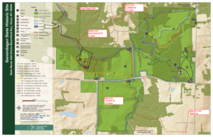 Ganondagan is the site of a large 17th century Seneca town, and offers hiking trails with interpretive markers illustrating the history and traditions of the Seneca people. The trails will take us through wooded rolling hills and meadows just south of the Village of Victor. Highlights will include the Granary Trail, where the Senecas protected and distributed their corn supplies on a palisaded mesa, and part of the Earth is Our Mother Trail, where interpretive markers describe local plants and their particular roles in Seneca life. Portions of the hikes will be in the Town of Victor’s Dryer Road Park, adjacent to the Fort Hill (Granary) portion of Ganondagan, and one hike will include a beautiful section of Victor Hiking Trails’ Seneca Trail, adjacent to Great Brook and its Beaver Pond.
All hikers meet at 3:45 at Dryer Road Park, 7405 Dryer Road, about 1 mile west of Route 444 and Dryer Road or 1.5 miles east of Malone Road in the Village of Victor. From there, Climbers and Naturalists will follow the Victor Hiking Trails pathway up the hill, past an open clearing and through a mature hardwood forest. Mountain bikers will know this area for its dense pattern of bike trails off to the sides of the main walking path. The trail leads to the open mesa at Fort Hill, where the circular Granary Trail offers expansive views as far as Bare Hill, and where interpretive markers describe Seneca life and history, their use of the protected mesa, and the conquest and destruction of Ganondagan during the 1687 Denonville Raid. Naturalists will circle the Grainary Trail and the open clearing and return to Dryer Road Park for a total hike of about 2 miles.
From the Granary Trail, Climbers will head east down the Eagle Trail, through more beautiful hardwood forest and across School Street to the Ganondagan village site and surrounding woods and fields. This group will explore the Seneca Trail and Grasslands Trail, looping through the hardwood forest and then an open meadow, returning to the Grainary area and Dryer Road Park for a total hike of about 5.2 miles.
Tourists will leave their dish to pass in someone else’s car at Dryer Road, then drive/car pool to the Apple Farm at 1640 Route 444, Victor. Park near the retail store to the rear of the main house. We will then hike west through the back lands of the Apple Farm to the Seneca Trail and head north along Great Brook to Boughton Hill Road. Crossing the road to the Ganondagan lands, we will head north next to School Street and turn west into the woods and up the hill to the Grainary Trail and the scenic overlook to the south. After looping around the Grainary, we will re-enter the woods into Dryer Road Park and back to the cars. Tourists will be driven to retrieve their cars at the Apple Farm at the conclusion of the social.
Please join us for a dish-to-pass social (optional) at the picnic pavilion at Dryer Road Park. Bring something delicious and nutritious, or make a contribution to our refreshments fund. BYO beverage.
Directions:
From Springwater/Honeoye area: Go north to Honeoye and then east on 20A to Route 64. Go north on 64 for 3.7 miles to the 5 and 20 intersection. Go west on 5 and 20 for 1.25 miles and make a right on Route 444 (Maple Ave.). Proceed 6.2 miles to Dryer Road (bottom of the hill, past the flashing light). Turn left at Dryer Road and go 1.4 miles to the entrance to Dryer Road Park, on your left. If you come to Malone Road, you have gone too far.
From points east: Take 5 and 20 west toward Bloomfield. Go right at the Route 444 intersection, and proceed 6.2 miles north to make a left on Dryer Road. Go 1.4 miles to the entrance to Dryer Road Park, on your left. If you come to Malone Road, you have gone too far.
From Rochester: Take Route 64 South from Pittsford to Mendon, and go east on Route 251 at the town center. In 1.5 miles make a right on Strong Road and then in 1.5 miles a left on Dryer Road. Dryer Road Park will be on the right in 1.6 miles.
Webinar: Tuesday July 16 2019 at 12:00 Noon
Speaker: Dr. Lori Spears, USU Assistant Professor
Date: Tuesday, July 16, 12:00 pm (MDT) – Please ignore the date in the title; it is an unavoidable posting date and NOT the date of the webinar!
The spotted lanternfly has been identified as a nasty invasive insect that is busy killing trees in Pennsylvania. The forestry and university authorities in PA have launched a series of webinars aimed at educating hikers such as ourselves in identifying and reporting these marauders. There’s is one coming up on 16th July; you are invited to join in from the comfort of your own home – we may be able to help limit this beast in New York.
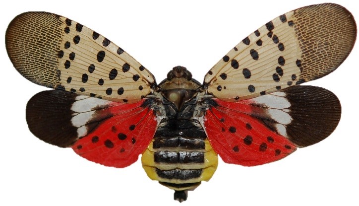
Spotted lanternfly is an invasive planthopper that is native to parts of Asia and was first detected in the U.S. in Pennsylvania in 2014. Spotted lanternflies feed on a wide range of host plants, including grapes, fruit trees, hops, and hardwood ornamental trees. This presentation will cover the biology, identification, and possible control options for spotted lanternfly and other invasive landscape tree pests, such as emerald ash borer and Asian longhorned beetle.
Lori is the Cooperative Agricultural Pest Survey (CAPS) Program Coordinator at Utah State University. The CAPS Program is a federal program coordinated by the United States Department of Agriculture (USDA) Animal and Plant Health Inspection Service (APHIS) Plant Protection and Quarantine (PPQ), and whose goal is to protect U.S. agriculture from introductions of high risk invasive pests by conducting early detection surveys and providing outreach and education programs that support and enhance efforts to prevent new exotic pest entry and establishment. Her research and outreach programs have focused on the ecology and management of invasive insects and using bycatch from early detection surveys to learn more about beneficial insects, such as pollinators and lady beetles. Lori received a PhD in Ecology from Utah State University in 2012.
Co-sponsored by Utah State University Integrated Pest Management Group
|
|||||||||||||||
Volunteers Needed for Invasive Species Restoration Team!
Cumming Nature Center is seeking volunteers to help restore its nature preserve in Naples, NY, this summer, with a kickoff event during Invasive Species Awareness Week! Join us on Thursday, July 11, 2019, from 9 am to 2 pm, to help remove Japanese Barberry! Please contact Cumming Nature Center at (585) 374-6160 to sign up or for more information! Cumming Nature Center is located at 6472 Gulick Road, Naples, NY.
Cumming Nature Center seeks large and small groups, as well as individuals, to help remove Japanese barberry infestations so that we can seed native plants, restore native habitats for wildlife, and protect the surrounding Honeoye Lake watershed. Japanese barberry is an invasive shrub which is spreading throughout our Naples preserve, harming and eliminating our native habitats. We welcome everyone to come join our ongoing Restoration Team!
Please wear long work pants, long sleeves, socks, and boots or work shoes, since removing Japanese barberry is somewhat like working with rose bushes. And bring a water bottle and lunch! Cumming Nature Center will provide directions, equipment, and protective gloves and gear, so that we can work efficiently to combat this invader! CNC will have water available and provide light refreshments after..
Can’t make this event? Further invasive removal events at Cumming Nature Center are listed below:
Saturday, July 20, 2019
Thursday, August 1, 2019
Saturday, August 10, 2019
Sunday, August 11, 2019
Saturday, August 31, 2019
Saturday, September 7, 2019
Thursday, September 19, 2019
Saturday, October 5, 2019
Thursday, October 17, 2019
Saturday, November 2, 2019
— Cumming Nature Center
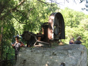
This Sunday people will have the choice of bike riding the Keuka Lake Outlet Trail or hiking a section of it. The trail follows Keuka Lake’s outlet to Seneca Lake, starts in Penn Yan and goes approximately 7 miles to Dresden dropping 275′ along the way.
This trail runs along the stream in a wooded ravine, it was “formerly a canal towpath and later a rail road bed, it crosses the original Pre-Emption Line and passes near the area of the first permanent white settlement of ‘The Universal Friend Jemima Wilkinson’, along waterfalls and ruins of mills, factories and canal locks”.
 Everyone will meet at the Seneca Mill Access parking area on Outlet Road at 4:00 PM. From there, bikers can go out and back both ways on the trail for a total of up to 14 miles. Well suited for hybrid or mountain bikes, the trail is a combination of dirt, gravel and asphalt and somewhat uneven. Hikers will divide into two or three groups depending on how far people choose to hike in the two hours that they have. All groups should plan to take in the Seneca Mills & Falls site (.2 miles west of the parking area) and the Cascade Mills & Falls site (1 mile east of the parking area).
For those who would like to get something to eat and drink before heading home, meet at the Silver Bird Woodfired Pizza at 133 E Elm Street, Penn Yan. If the weather is nice we will probably eat out on the deck. Check out their website and preview their menu.
Some maps of the outlet trail will be available at the beginning of the hike: you can print your own map from the The Friends of the Keuka Outlet Trail website.
Directions:
From Springwater, Wayland and Naples. Head south from Springwater on NY-15 south to Wayland, then turn left NY-21. Follow NY-21 for 12.7 miles through N Cohocton and Naples. Turn right on NY 245N across from Bob Ruth’s. Follow NY-245 for 8.9 miles to Middlesex and take a slight right turn onto NY 364E. In the Village of Penn Yan, turn right onto Liberty St., turn left onto Clinton St (State Route 54 North) and follow it 2 miles, turn right onto Bentley Rd (which becomes Bell Road) and go for 1 mile, turn left onto Outlet Road and go for .7 miles, parking area is on right.
This week Springwater Trails will return to the Erie Canal for a walking, biking, or kayaking tour of the Erie Canal through Fairport, NY. The Town of Perinton was established by the New York Legislature in 1812. When the Erie Canal opened in 1823 the hamlet of Perrinsville grew steadily around the “fair port” on the canal that marked the east side of the crossing of the Irondequoit Creek. The hamlet was incorporated as Fairport in 1867.
All hikers, bikers and boaters will meet at the boat launch on Ayrault Road. Please arrive early to allow time to unload boats and bikes and to park your cars in the boat launch lot. We will start the hike promptly at 4:00. Following the hike, you are invited to join us at Mulconry’s Irish Pub and Grill at 17 Liftbridge Ln E in Fairport for dinner and socializing.
In order to free up parking spaces for boaters at the boat launch, Hikers will carpool to the Fairport end of the trail. (see directions below). This hike will be an out and back, so please keep track of time. From the parking lot, head west on the Canal. Hikers will go under the lift bridge (note that the bridge is higher on one end – I think it is the only lift bridge that isn’t level). Next you will pass Erie Boat Rentals where you can rent kayaks and bikes for $21 for 2 hours. A mile down the trail is Perinton Park with swings and benches to rest. Continuing under Fairport Rd (NY 31F), the Fairport Crew Club docks will be on your left. Continue on toward Ayrault Rd until about 5:20, at which point hikers should turn around and head back to the cars and the social.
Boaters will put in at the boat launch and head north toward Fairport. In a half mile, you will see an oxbow to the right – a couple of islands with the original creek bed around them. Enjoy exploring this little harbor. Another mile ahead, you will pass under Fairport Rd (31F). The Fairport Crew Docks are on the left before the bridge, and Perinton Park is also on the left just after the bridge. The total distance to Main St in Fairport is 2.5 miles, a pleasant trip that can be completed out and back in 2 hours. However, all boaters should turn around shortly after 5:00, planning to arrive back at the boat launch at 6:00.
Bikers will ride both directions on the canal path. Leaving from the boat launch, turn right on Ayrault Rd to cross the canal. About 200 ft past the bridge, turn right on the access trail, then right on the canal path toward Bushnell’s Basin. Its about 5 miles to the Great Embankment Park on the right. From that park, turn around and ride past Bushnell’s Basin past Ayrault and continue on toward Fairport. If you turn around at the lift bridge on Main St, you will have about a 10 mile ride. Or continue on through the village to Lyndon Rd (large ramp up to the road level) means a 14 mile ride.
Directions to the meeting point at the Ayrault Rd boat launch.
From Springwater: From the flashing light in Springwater, head north on NY 15A for 13 miles. You will pass through Hemlock. When US-20A bears to the left, and 15A continues straight, you should turn right on Richmond Mills Rd (CR-41). In 4 miles, turn left onto CR-37. In West Bloomfield continue straight onto NY-65. In 0.7 miles, when NY-65 curves to the left, continue straight onto CR-35 (W. Bloomfield Rd). In 9.8 miles turn right on Thornell Rd. At the T, turn right onto NY-96. In the hamlet of Bushnell’s Basin, turn left onto Kreag Rd. Continue through the light at NY-31. At the T turn left onto Ayrault Rd. The boat launch will be on the right before the canal.
From Naples: Head north on NY-21. In about 7 miles continue straight onto NY-64 (NY-21 takes a right). Continue on NY-64 past Bristol Mountain. After 13.3 miles on NY-64, at the stop light, turn left onto US-20. In 1.3 miles turn right onto NY-444. It is 6.8 miles to Victor. Turn left onto NY-96. Stay on 96 for 2.9 miles. Take the I-490W entrance to the right. Take exit 26 for NY-31 – turn left on NY-31. At the light (0.2 mi) turn left onto Ayrault Rd. In a mile, the boat launch is on the left, just past the canal.
Directions from the boat launch to Fairport and the social at Mulconry’s: From the boat launch turn left onto Ayrault Rd. At the stop light, turn left onto NY-250. Continue through Fairport and cross the canal. Take the first right after the canal (before the railroad tracks) on Liftbridge Ln. You can park in the lot on the right between Liftbridge Ln and the Canal. Mulconry’s is across Liftbridge Ln.
The Steuben County Fairgrounds in Bath, NY will be transformed into a celebration of all things outdoors on Friday, July 26. The Finger Lakes Trail Conference along with the Steuben County Conference & Visitors Bureau and Friends of the Chemung River is excited to present the first Finger Lakes Trail Days over two jam packed days.
Kicking off the festivities Friday night is a concert featuring the Grammy Award winning bluegrass band, Steep Canyon Rangers. The duet of Rob Ickes and Trey Hensley will show off their guitar and vocal prowess warming up for the Steep Canyon Rangers.
Doors open at 6:00 pm and food and drink will be available.
Tickets can be purchased for either Friday evening’s concert or for Saturday; a two-day pass is also available. For more information on tickets, activities, on-site camping opportunities and the music schedule visit www.fingerlakestraildays.com or contact info@fingerlakestraildays.com
The Steuben County Fairgrounds in Bath, NY will be transformed into a celebration of all things outdoors on Friday, July 26. The Finger Lakes Trail Conference along with the Steuben County Conference & Visitors Bureau and Friends of the Chemung River is excited to present the first Finger Lakes Trail Days over two jam packed days.
Whether you are an outdoor enthusiast who already spends weekends hiking, biking, kayaking or fishing/hunting or someone who has always thought about trying something new, Saturday is filled with outdoor recreation activities of all kinds.
Additionally, enjoy local food, drinks, and a remarkable musical line-up. From 8:30 – 3pm there will be hikes of varying lengths and difficulty levels (click here for more information).
Also, check out the guided tours of places of interest in the area.
Beginning at 11 am at the Fairgrounds, attend one of the many interesting presentations, ranging from Geocaching to Yoga, Birdwatching to Medicinal plants and more.
Local food trucks and beer garden will be available all throughout the day.
Attendees can also experience a zip line, climb a rock wall, learn to kayak or mountain bike and navigate a ropes course.
There is a stellar lineup of outdoor exhibitors available to answer questions and provide information about their organization. Hiking groups from around the state will be available.
And meet the experts to find out more about birding, conserving land, our local rivers or monarchs.
Throughout the day you will hear a music line-up featuring Sawyer Fredericks (the 2015 winner of The Voice), Cicada Rhythm, Joshua Davis, Aaron Lipp & the Slack Tones, and Joseph Alton Miller.
There are plenty of activities for the entire family!

Looking for brochure.or mailing list so I can receive it in the mail.
Nothing opens up for mailing list.
There’s all kinds of very bizarre ads and post for viagra and other drugs above on calender page.
Please let me know if there’s a brochure available