
Hikes led by Springwater Trails are generally held on Sunday afternoons and appear in this calendar in green.
| Sun | Mon | Tue | Wed | Thu | Fri | Sat |
|---|---|---|---|---|---|---|
| West Side of Hemlock Lake 2:00 pm West Side of Hemlock Lake @ Blank Rd Parking area Oct 1 @ 2:00 pm – 4:00 pm 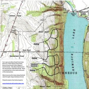 This Sunday we are returning to the upper trails on the west side of Hemlock Lake. There are several loops that have been mowed and we will take advantage of them to create Naturalists, Tourists and Climbers hikes. Following the … Continue reading | ||||||
| Naples Honor Society Landscaping Project 12:30 pm Naples Honor Society Landscaping Project @ Hanggi Bridge Oct 8 @ 12:30 pm – 3:00 pm  The NCS Honor Society has offered to do some maintenance and construction work on the BHB in Naples as part of their community service commitment. They will be working on the landscaping around the new bridge on Gideon Hanggi’s land. … Continue reading | Genesee Valley Greenway State Park Passport Series – 2017 – hike #7 on 2nd Saturday of October 10:00 am Genesee Valley Greenway State Park Passport Series – 2017 – hike #7 on 2nd Saturday of October Oct 14 @ 10:00 am – 12:00 pm Genesee Valley Greenway State Park Passport Series – 2017 – hike #7 on 2nd Saturday of October Historic Interpretive Hike Series (Wegmans Hike #7): – – – Please check the online sources below for particulars of this hike. – – … Continue reading Trail Maintenance Management Meeting 10:00 am Trail Maintenance Management Meeting @ Fire Hall Oct 14 @ 10:00 am – 2:00 pm Springwater Trails has agreed to maintain the Bristol Hills Branch of the Finger Lakes Trail between Clement Rd and NY 245 in Naples. The FLT is sponsoring a workshop on trail mainentance on Oct 14th in Bath. This is an … Continue reading | |||||
| Bristol Hills Branch Hike #4 2:00 pm Bristol Hills Branch Hike #4 @ Prattsburgh Oct 15 @ 2:00 pm – 4:00 pm  The fourth hike in our Bristol Hills Branch series will be called the up and down hike.The longest climb on this section will be 300 feet in elevation over half a mile, but there are two of those plus a … Continue reading | ||||||
| Ontario Pathways, hike and bike 2:00 pm Ontario Pathways, hike and bike @ Ontario Pathways, east end Oct 22 @ 2:00 pm – 4:00 pm Just when you thought we had moved out of the picture, here we are again, leading a hike in our new Ontario County location. We have hiked the nice, flat Ontario Pathways Trail, converted from a former railroad bed, before, … Continue reading | ||||||
| Mitchellville Gorge FLT 2:00 pm The FLT Through Mitchellsville Creek Gully 2:00 pm The FLT Through Mitchellsville Creek Gully @ FLT Access Point 6 Oct 29 @ 2:00 pm – 4:00 pm  NOTE: It’s hunting season! Please wear bright colors, preferably orange. The hike on Sunday 29th October will follow a section of the main path of the Finger Lakes Trail in Urbana, just south of Hammondsport. It’s a short easy hike, … Continue reading |
The fourth hike in our Bristol Hills Branch series will be called the up and down hike.The longest climb on this section will be 300 feet in elevation over half a mile, but there are two of those plus a third climb of about 150 feet. So this hike is a challenge to select a sections that are less steep, so you will find that the hikes are a little shorter than usual, allowing some time for catching our breath.
All hikers will meet at Access Pt 15 on CR 77. This is the same spot that we meet last month.
The Naturalists and Tourists will carpool to Williams Rd to the north. This hike starts with a short step descent from the road, followed by a half mile of uphill. A downhill section through woods and down shared driveway will cross CR 74 and follow Presler Rd into the Bud Valley Campground. This is the targeted end of the Naturalist hike and cars will be pre-staged here. Based on the interest of the hikers, and the time, the Naturalists can explore the campground or continue on with the trail as it climbs to an abandoned road and another high point. The Tourists should check their watches at this high point and turn around to return to the campground.
Meanwhile, the Climbers will leave CR 77 and head north on the BHB. The trail immediately starts a climb to about 1600′ and to open views to the north. After crossing a creek, the trail turns west to follow an abandoned road between fields and descends to the campground. Continue to follow the campground driveway north to CR 74. After crossing the road, we continue north along an old shared road. Follow the blazes and don’t miss the sharp left off the road. This hike ends at Williams Rd at the Naturalists cars. Hikers intent on completing all of the BHB trail should turn right and follow the road to the next driveway where the trail enters the woods to the left. We will continue the trail at this point after hunting season.
Following the hikes we will need to find all of the cars and then return to Naples for a social.
Directions:
From Springwater (and Wayland, N Cohocton and Naples): Take Rt 15 South to Wayland. At the stop light, turn left and follow Rt 21 through North Cohocton (take a left at the stop sign) to the south end of Naples. At the stop sign, turn right onto NY 53S for 12.1 miles. Turn left onto Waldo Rd. Continue straight onto CR 77 (Shuart Rd). In 2.3 miles, parking is on the right hand shoulder just past the “Pulteney” sign.
From Bath: Take Exit 37 from I86 (NY 17) for NY 53. Head north on NY 53 for 8.8 miles. Turn right onto Bean Station Rd and take the first left (in 0.4 miles) on Muck Rd. At the end of Muck Rd, turn right on Shuart Rd. Parking is on the right in 1.6 miles.
Directions to Williams Rd: Head west on CR 77. Stay on Cr 77 (turns to right) at Waldo Rd, and continue past Flynn Rd. The next right is Trant Rd which continues straight onto Williams Rd. The trail head is 0.3 miles up on Williams Rd.
Just when you thought we had moved out of the picture, here we are again, leading a hike in our new Ontario County location. We have hiked the nice, flat Ontario Pathways Trail, converted from a former railroad bed, before, but usually, at the west end, by Canandaigua. This day, we’re going to explore a section we haven’t gone to before, a part of the east end, north of Stanley. Our meeting place is the parking lot on CR 20, just north of US 20. Detailed directions from Springwater are below.
Climbers and tourists will car pool north on CR 20, to the parking lot by the Orleans water tower, where SR 488 makes a right angle turn to the north. They will then walk south, on the OP trail, to the meeting point. Tourists will walk straight down the main trail and climbers will also explore 2 loop trails, east of the main trail. Naturalists will be driven to Ferguson St., where they will walk to the trail, then south on the trail to the meeting point.
The nice, flat trail is conducive to a nice autumn bike ride so, we’re also offering this option, this day. Bikers will ride south on the trail, to the parking lot in Stanley. There, they will ride the trail, northwest, across 5&20, to Spangle St. Ride north on Spangle, east on CR 4 to the trail, and south on the trail to the meeting point.
Hoping for a nice fall day, late October should still be warm enough for us to have a picnic social at the parking lot where we meet, maybe he last one of the year. Bring chairs, a folding table, if you have one, and a dish to pass. However, if one of you tries to feed margarine to Mother Nature, getting her to show her nasty side that day, we’ll reserve the option of going inside. I don’t know of any place between Stanley and Canandaigua that’s open Sunday afternoon so, think of some place in Canandaigua. I’ll check the weather forecast around the end of the week and post a final decision.
UPDATE: Congratulations! All of you have been nice to the sweet lady and, to show her gratitude, looks like she’ll be giving us an autumn day, for our hike this Sunday, that couldn’t be better if you tried, with lots of sunshine and temps in the 70s, perfect for an outdoor picnic after the hike. So, prepare one of your great culinary creations for us to enjoy, concluded by one of Char Buck’s fabulous desserts. Also, pack some folding chairs. We’re bringing a folding table but, if you have one you can bring, we could probably use it too.
From Springwater, go north on SR 15A, then east on US 20A. Turn right and continue east on US 20. At CR 20, turn left. The parking lot is immediately on the right, after you turn. Springwater Town Hall at 1:00 or Honeoye Shopping Plaza (Surefine, CVS) at 1:15 are suggested car pool locations.
And finally, for all you brilliant trivia gurus, “It’s not nice to fool Mother Nature” was an ad for what product?
May the Schwartz be with you. See you Sunday.
NOTE: It’s hunting season! Please wear bright colors, preferably orange.
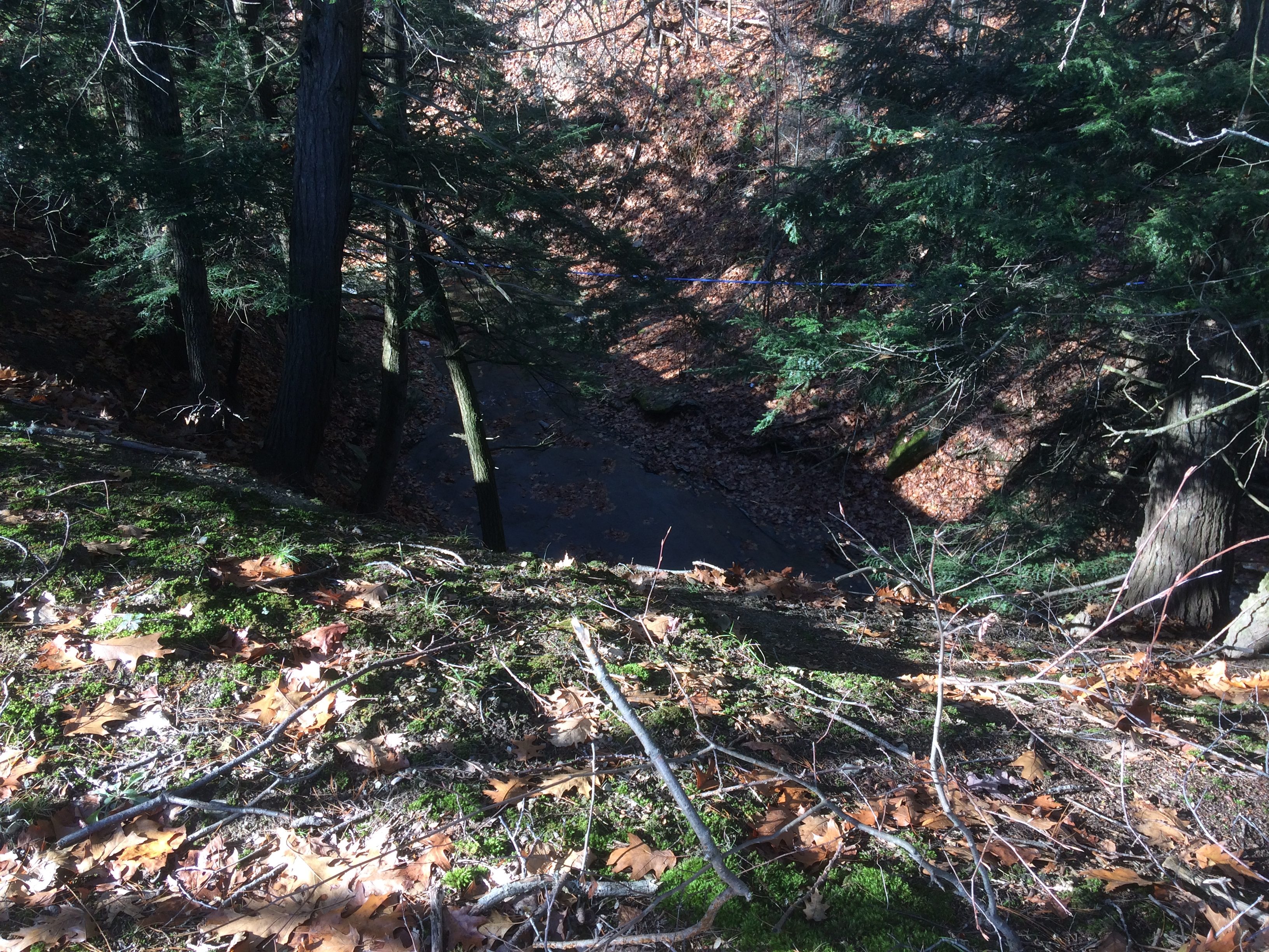
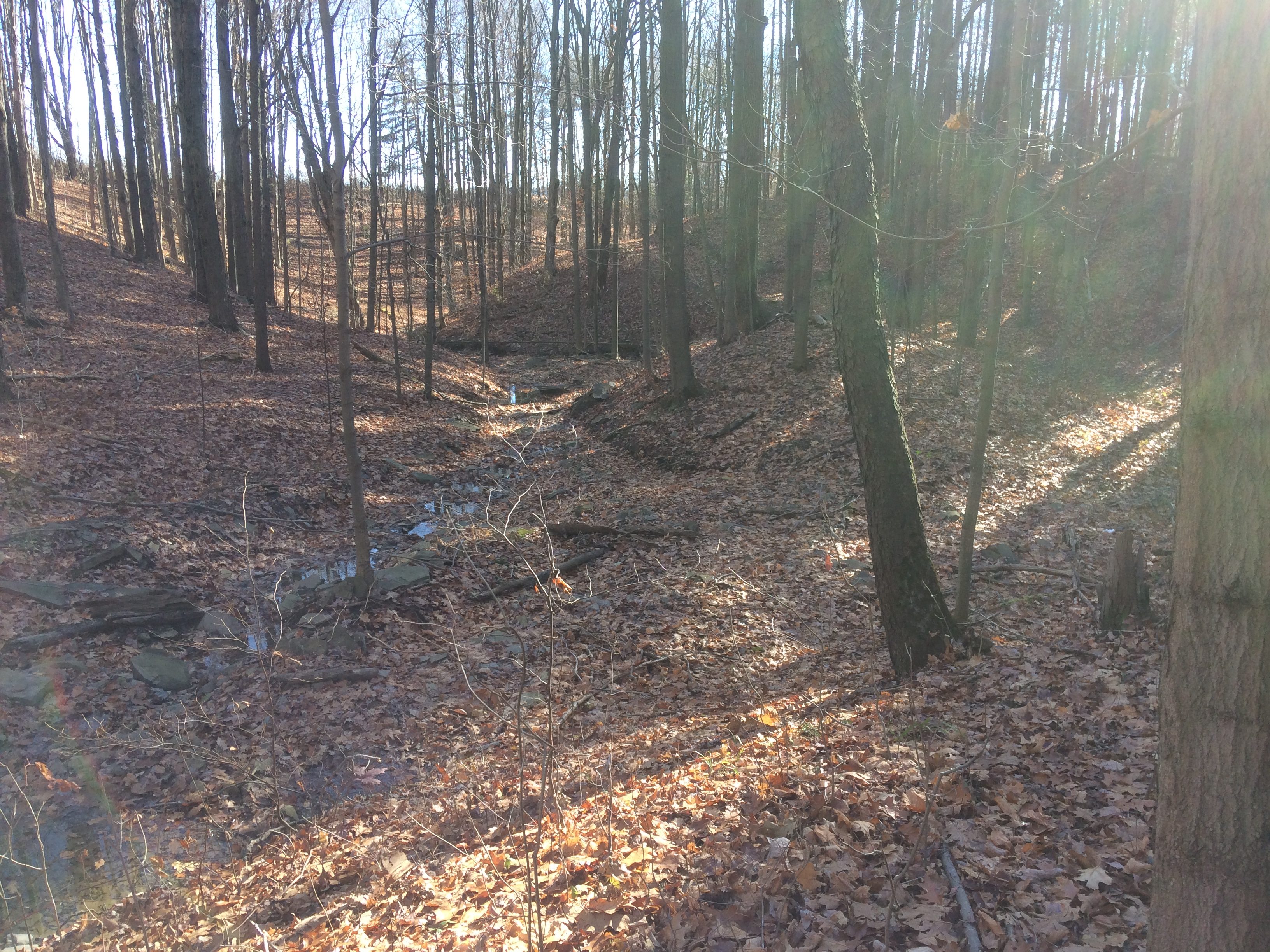
The hike on Sunday 29th October will follow a section of the main path of the Finger Lakes Trail in Urbana, just south of Hammondsport. It’s a short easy hike, just 2.6 miles, and it follows the rim of a deep gully cut by the Mitchellsville Creek. This section slopes gently downhill from north to south with just a few short steep sections. The northern two thirds passes through a dense hemlock wood, and the path is a soft bed of hemlock needles, and there are views of the deep gully along the way. There are two ‘beauty spots’ along the route; about a third of the way from the top there’s a short side track that juts out over the gorge, giving good views from a height, and about two thirds of the way down there is a pretty creek. Unfortunately, we can’t get too close to either spot; this section of the trail is on private land and we can’t wander off it. The gorge overlook is crumbling and is dangerous, and access to the creek is specifically denied by the land owner.
We will meet at the FLT trailhead on Route 54 in Urbana, by the Pleasant Valley Inn (42.388729, -77.260357) at 2:00pm.
The Climbers will shuttle to the high point of the hike at FLT access point 5 on Mitchellsville Road (42.404269, -77.290893), and then walk down the FLT back to the meeting point.
The Tourists and Naturalists will start at the meeting point and walk up the trail. They will walk a short distance north on Rt. 88 and then go left on the FLT through a vineyard. At the end of the vineyard the trail crosses a stream and then rises up through the gully to a pretty spot by the creek. There are no steep sections on this stretch. Those who want to can carry on up the trail can do so, but there are some short but more difficult sections to navigate.
An alternative for the Tourists and Naturalists is to walk the Hammondsport historical trail. It is a walk around the village of Hammondsport, and it is marked by purple grape emblems painted on the sidewalks and signs attached to lamp standards. A brochure will be available that describes sites of interest along the trail.
The Social
The social will be held at the Aroma Coffee and Art Gallery at 60 Shethar Street in the village of Hammondsport. It is just off the green, at the side of the church. It serves coffee and snack food such as soup, sandwiches and baked stuff. If we want to continue socializing after 5:00pm, the Pleasant Valley Inn bar will open and we can hang out there too.
Directions
From Honeoye: Follow W Hollow Rd (County Road 36) to Naples. Turn Right at the Middletown Tavern on to Rt. 21 South, and then bear left on to NY-53 South. Continue for 17.1 miles through Prattsburg and then turn left to County Rd 13/Mitchellsville Rd in Wheeler. Turn right when this road ends and folow this road (Route 89) to its junction with route 54. The parking area and trail head is on the left.
From Naples: Take NY-21 South, and then bear left on to NY-53 South. Continue for 17.1 miles through Prattsburg and then turn left to County Rd 13/Mitchellsville Rd in Wheeler. Turn right when this road ends and folow this road (Route 89) to its junction with route 54. The parking area and trail head is on the left.
From Rochester: Take NY 15 south to the I-390, and then I-390 South to the NY 54 / Bath exit, then follow NY54 north to the Pleasant Valley Inn.The parking area and trail head is on the left.
From Springwater and Wayland: Take 390 South to the NY 54 / Bath exit, then follow NY54 north to the Pleasant Valley Inn.The parking areaand trail head is on the left.
TOWN OF SPRINGWATER
OPEN HOUSE
For NEW
TOWN HIGHWAY BARN
8319 Hudson Road, Springwater, NY
November 4, 2017
10:00 am to 2:00 pm
Fun for the whole family – food and beverages will be provided.
Come on down and help us CELEBRATE!
This Sunday we will return to Wesley Hill Nature Preserve for a fall loop hike around the perimeter from the Gulick Road parking area, staying clear of the western sections where bow hunting is in progress. Wesley Hill is a Finger Lakes Land Trust property of 390 acres including stands of northern hardwoods, red and white pines, a woodland pond, and the northern edge of Briggs Gully, as well as the Wenrich Cabin, set in an old forest overlooking the gully, deep in the woods. A network of trails through the preserve offers excellent hiking routes of various lengths and levels of difficulty.
The preserve was founded in 1999 by the generous donation of 90 acres by the children of three artists – John Wenrich, James Havens and Colburn Dugan – to the Finger Lakes Land Trust. Since that time, the Land Trust has expanded Wesley Hill to over 390 acres through the purchase or donation of four additional parcels.
We will meet at the parking lot on Gulick Road. The Climbers will hike the Red and Orange Trails (plus a small section of Yellow Trail) in a clockwise direction, with a challenging side trip down into Briggs Gully and back on the Green Trail for a total of about 5 miles. The Tourists will hike the Red and Orange Trails (plus a small piece of Yellow) in a counter-clockwise direction, for a total of about 3 miles. The Naturalists will hike to the pond and into the relatively level woods beyond on the Red Trail, retracing their steps for a total of about 1.5 miles.
Following the hike, please join us for an optional social at the Honeoye Boat House at the Trident Marina at 5226 East Lake Rd, Honeoye, NY.
Directions:
From Honeoye: take route 20A east through Honeoye to East Lake Road (CR 33). Turn right onto East Lake Road. (If coming from Bristol or points east, its a left onto East Lake Road). Take the first left, staying on CR 33, then the first right onto Pinewood Hill which becomes Gulick Road. Travel about 5 miles to Wesley Hill Parking Area on the right side. Parking lot can fit about 10 vehicles; the rest of us can park on the side of the road (it’s paved).
From Springwater: Head north on Rte. 15A toward Hemlock. Just before Hemlock, turn right on Rte. 20A. Follow Rt 20A to Honeoye and then follow the directions above.
From Naples: From the southern end of Naples, head west on Co Rd 36. Follow Co Rd 36 for 1.2 to the first right turn on Gulick Rd. Follow Gulick for about 7 miles. The parking area is on the left.
Directions to the Social from the trailhead:
Via the seasonal part of Wesley Rd.: Turn left out of the parking area and head north on Gulick Road. Turn left on Wesley Road, the first left. At the bottom, turn right on East Lake Rd. The marina is on the left in 3.1 miles. The Boat House Grill is in the back of the building with a view of the lake.
Via Gulick Rd: Turn left out of the parking area on Gulick Road. In about 3 miles, the road bears left and becomes Pinewood Hill Rd. At the stop sign, turn left to stay on Pinewood Hill Rd (CR 33). In 0.4 mi, turn left onto E Lake Rd. In 0.8 miles, turn right at the sign for Trident Marine. The Honeoye Boat House Grill is about 150 feet down on the back of the building with a view of the lake.
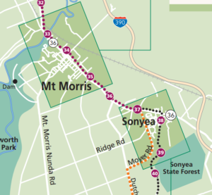 Springwater Trails (SWTs) will join the Friends of the Genesee Valley Greenway (FOGVG) for the events they have planned for their Hike, Bike, Program, Dinner and Annual Meeting. Below is the information posted on their website. SWTs is adding one additional option for our hikers – climbers can meet at 1:00 at the pull off south of the Village of Mount Morris on Route 36 just north of Swanson Road. They will then hike 3.6 miles on the Greenway to the parking area in Sonyea State Forest and then along Keshequa Creek as time allows. The “out and back walk” described below is recommended for SWT Naturalists and Tourists. Meet at the VFW parking area behind their building at 3 Elm St. in downtown Mt. Morris at 12:00.
Please note, hikers going all the way to the end and those electing the “out and back” option need to register with Irene Szabo to assure that she knows how many hikers need rides and that there are enough vehicles at the destination point. To register with Irene, email treeweenie@aol.com, or call at 585/658-4321
FOGVG Events in Mt. Morris-Sonyea: Hike, Bike, Program, Dinner & Meeting
WHEN: November 12, 2017 all-day
WHERE: VFW Building
3 Elm St. Mt. Morris NY
CONTACT:
Joan Schumaker
585-490-3302
Experience hiking or biking the Greenway in Mt. Morris and on the newly opened Sonyea section.
Travel 7.25 mi. by starting at the Pocket Park at the Greenway Bridge over the Genesee River or reduce length by starting at one of the new Greenway Parking areas in Mt. Morris, the last official GVGSP parking areas for this event. There is absolutely no parking near the prison area in Sonyea.
At 4.9 miles, turn right, west, across NY 36 into Groveland Correctional grounds, staying strictly on the paved route marked with green on white Greenway signs. After end of old brick buildings, climb gently on dirt road. Mile 6 is the approximate end of prison property with metal gate, and entry into Sonyea State Forest. At first continue west on old dirt road past bushy thickets that once were farms and vineyards. This whole 1670 acre property owned by the state came from a “Shaker” colony and was eventually divided between the Dept. of Corrections and the State Forest. Soon come to a T-intersection; turn RIGHT on the road and descend into forest, then curve left to stay with road until a big parking area at 7.25 miles that is the pick up point. For a ride back to your cars, you need to plan your hike or ride to arrive at this destination by 3:30 pm.
There is also a 4 mi. option for an “out and back walk” of new Greenway route within the Correctional Facility and Sonyea State Forest, with potential for optional side foray into the Keshequa Creek valley where the original canal and railroad used to run. Meet at the VFW parking area behind their building at 3 Elm St. in downtown Mt. Morris at 12:00, in the first block off Main Street going south. This group will caravan to the State Forest and provide rides back to Mt. Morris for the long distance hikers at 3:30 pm.
All participants in the above options should bring water and any food they will need. Hikers going all the way to the end and those electing the “out and back” option also need to register with Irene Szabo to assure that we know how many hikers need rides and that we have enough vehicles at the destination point. To register with Irene, email treeweenie@aol.com, or call at 585/658-4321
The program, dish-to-pass dinner, and FOGVG meeting take place at the VFW building at 3 Elm Street. Refrigeration and ovens are available. At 4:30 pm, Pat Coate from Allegany, NY will present a most interesting program on “Hiking the Appalachian Trail.” Dinner will follow at about 5:30 pm. Please bring your own table service and food to share. The brief Annual Meeting will take place after dinner.
Everyone is invited. Take part in one or more of the above events. Why not join us for all of them.
This Sunday, Springwater Trails will continue our monthly hike series on the Bristol Hills Branch of the Finger Lakes Trail.on the hills east of Italy Valley. Next month we will hike down from these hills to Italy valley but for this hike we will stay between 1400ft and 2100ft. As of Friday, Snow and temperatures at 32 are predicted. Expect some slippery slopes where walking sticks will be helpful.
NOTE: Due to hunting season closures, we will be skipping the section of the Bristol Hills Branch between Williams Rd and Pulteney Rd. But don’t worry, we will return to this section in January.
The trail from Pulteney Rd to Dunn Rd begins and ends with road walks. The 2.1 mile off road portion will form the heart of our hikes, of which we will have three levels.
All hikers will meet at the parking area at the end of Dunn Rd. This will be the end point for the Climbers and Tourist hikes. From the parking area, we will all carpool to the two starting points, while dropping off cars to pick up the Naturalists on CR 34 (Italy Turnpike).
IMPORTANT: If you are a Naturalist (wanting to hike 2.1 miles) and are willing to arrive at 1:45 to leave your car to transport Naturalists back to our meeting place, please RSVP by email to info at springwatertrails.org.
 The Climbers‘ hike (4.8 miles) will include all road walks for hikers who want to complete the entire BHB. We will start at Access 11 with a road walk along Pulteney Rd. The road has a gradual downslope to Fivemile Creek. This is followed by a steep climb up about 120 ft, where the orange trail leaves the road to the left.The trail is fairly level for 2.1 miles. We will travel along a corn field before entering a Sugarbush around a beautiful stream with small waterfalls. The first road we cross is Italy Hill Rd. Turn left and walk a hundred feet to the next hedge row. It is the same at Wetmore Rd – turn left on the road to the first hedgerow. At Emerson Rd the trail continues just a bit to the right.We will come out on onto CR 34 at mile 3. From this point, turn right on CR 34, and then left on Dunn Rd, to finish at the original gathering spot. Cars that were left at the end of Dunn Rd, can be used to retrieve the climber’s cars on Pulteney Rd.
 The Tourists and Naturalists will start at the point where the trail leaves Pulteney Rd north of Access 11. Since the Tourists are hiking farther (3.9 miles) than the Naturalists (2.1 miles), they should take the lead. The trail will cross three roads (Italy Hill Rd (go left), Wetmore Rd (go left) and Emerson Rd (slight right)) before coming out onto CR 34 after 2.1 miles. We will have a car waiting on CR 34 for the Naturalists, who can drive east on CR 34 to Dunn Rd and then back to the parking lot, Meanwhile the Tourists will continue to hike to the right on CR 34, and then left on Dunn Rd.
Following the hike, we will return to Naples for an optional dinner at the Redwood Inn.
Carpool instructions at the Hike: These instructions may be modified based on the number of hikers on the day of the hike.
One naturalist will be needed to drive the naturalists back to their cars. This person will drive their car from the Dunn Rd parking lot to CR 34. Another car will pick this driver up to go to the start of the hike.
The Climbers will drive all hikers to the start. They will head south on Dunn Rd back to CR 34, Turn left on CR 34. At the intersection with Italy Hill Rd, we will cross the road and turn right onto Pulteney Rd. Just before heading down the hill to Filemile Creek, we will stop to drop off the Naturalists and Tourists. The Climbers will then continue south east until the road turns east. This is Access where the trail comes in from the west. Climbers should turn around and park to the east of the access point on the north side of the road.
Directions: From the southern end of Naples, follow NY 53 toward Prattsburg. In 1.1 miles, turn left onto Italy Valley Rd (CR 21). In 5.5 miles, take a slight right onto Italy Hill Turnpike (CR 34). In 2.6 miles, turn left onto Dunn Rd. A large parking lot is at the end of the drivable portion of Dunn Rd. If the parking area is full, or too muddy, park along the road facing toward CR 34.
November 26th Post Pie Hike~
This Sunday we will hike the road along the West River at the south end of Canandaigua lake. Come work off that extra piece of pie and dollup of ice cream! This is a nice open space with room to walk side by side, chat and enjoy the spectacular views of Canandaigua lake plus it’s inlet. It will be primarily on Sunnyside Rd which is a low traffic area. There are just a couple of hills but manageable.
We will meet at the intersection of Sunnyside Rd and West Ave just north of Naples. The DEC parking area is on the right before the mailboxes.
Naturalists will meet with the group then continue up Sunnyside to the pull-off by the dumpster. They will walk along the roadway that offers beautiful views then retrace their steps to the cars, depending on time and fatigue.
 The Tourists and Climbers will set off from the DEC parking lot, walk along Sunnyside to the split where a dirt road rises on the right (for CLIMBERS) and the road dips down toward to the lake cottages on the left (for Tourists). Each group will follow the respective roadways until the first intersection then loop back as follows: the CLIMBERS will be bending down toward the lake whereas the TOURISTS will be taking the higher down hill portion back to Sunnyside. There is one slight drainage ditch that has a plank used for crossing. The views along the lake include migratory waterfowl, a wonderful shale cliff, and quaint lake cottages. Both groups will continue to the DEC parking area. The hike is approximately 4.5 miles.
DIRECTIONS: From Springwater/Dansville/Wayland: Take Rt 21N into Naples. Turn left onto Main St for 1.5 miles. Turn right on Rt#245 (across from Bob and Ruth’s). Continue 4 miles, make a left on Sunnyside Rd. Parking area is at the V just before the mailboxes.
From Honeoye: Take Rt#36 south into Naples, left on Main St for approximately 1.25 miles. Right on Rt#245 (Across from Bob and Ruth’s). Continue 4 miles then left on Sunnyside Rd.
From Canandaigua: Take Rt#364 to Middlesex. Keep straight onto West Ave. at the curve. Take all the way to intersection of Sunnyside Rd. Parking on the left over bridge.
The social will be at Amy’s cabin. Directions given at the hike. Please bring a dish to pass, leftovers or $5 donation if you are sick of cooking.
Looking for brochure.or mailing list so I can receive it in the mail.
Nothing opens up for mailing list.
There’s all kinds of very bizarre ads and post for viagra and other drugs above on calender page.
Please let me know if there’s a brochure available