Because of the distance from Springwater, we are starting this hike an hour earlier, so that we don’t get home too late. Be at the municipal parking lot on Clara Barton St., just south of Main, in Dansville, at 1:45. This way, we can organize car pools and depart for the bog, promptly at 2. If you want to carpool from the Springwater Town Hall, please be at the town hall by 1:25 to leave promptly at 1:30 to get to the Dansville carpool and the caravan to Hanging Bog.
Hanging Bog is a man made impoundment built by the CCC in the late 1930’s. The ‘Bog’ is located on portions of the Hanging Bog WMA and the Crabb Hollow State Forest. It is characterized by a floating mat of vegetation in the middle of the impoundment. The area is used for Ruffed Grouse population management. We may see Beaver, Heron, and hear many different bird songs. There are great cross country ski trails off of Brown Rd. which have been maintained by another group from Cuba, NY one of which the Tourists will utilize.
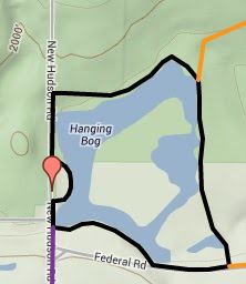
 First off everybody starts off South on New Hudson Rd. The Naturalists will take the Bog Trail a little over a mile and a third around the bog. This is pretty self explanatory as keep the bog to your left and/or follow red marks on trees. This is only important after re-entering from Federal Rd. and after you reach the campsite very near to New Hudson Rd. Otherwise you just keep the bog to the left.
Instead of entering the bog, the Tourists will proceed up New Hudson Rd. to Brown Rd. and enter the cross country ski trail back down to the bog. They will cross the tornado alley from a couple years ago which is just now being logged. They will then join with the bog trail at Federal Rd. (left then quick right). Total about 3 miles.
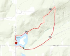
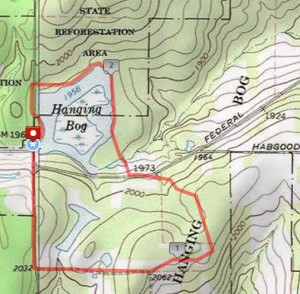
 The Climbers will do a loop a bit less than 4 miles. They will start out with the Naturalists but when the Naturalists re-enter the bog trail from Federal Rd. they will continue on down (veer to left) and make a left at the Hanging Bog WMA sign. At the access road continue down it for a mile or so and enter at the orange forestry tape hanging from the tree branch on the left. If you reach the orange tape trail on right, or the turn around, you have gone too far. This trail takes us through a variety of habitats and we can see some damage from the recent flash floods which swamped several cars at a nearby grad party. Three inches fell in one hour!
Not that you will be with the Climbers Gene, but that road is pretty accessible as I drove it several times with my Prius (not what I reccommend) and I also cleared some trail west in from the road at the turnabout prematurely ;-).
Coming here is kind of tricky. Just either come down 86 to the Angelica exit, north into town and make a left on W. Main St. Follow to it’s end at Rte. 19, make a right and follow until you reach Rte. 305 on left at or just before Belfast. Make a right onto Cloverleaf Rd., a left onto Federal Rd. and a right onto New Hudson Rd. and the parking area will be on your right. Click here for additional directions.
If you are coming in from the north I would suggest finding Rte. 19A to Rte. 19 to get to Caneadea, then taking a right on Hillcrest Rd. along the South Eastern Shore of Rushford Lake, make a left onto Rush Creek Rd. and follow to New Hudson, turn left (only option) and continue to the parking area and Hanging Bog on the left hand side. I think there may be a way in from 39 to Rushford and in via Hardys Corners Rd.; Baldwin Hill Rd.; Taylor Hill Rd.;Luce Rd.;Dolph Rd. (Rush Creek Rd.) I know it’s good from Rushford on in. I was born and raised on taking Short Tract Rd. up to Rochester, so I do what I know, and I haven’t been past Rushford that way since I was a kid.
Click here for a map of the hikes: https://mapsengine.google.com/map/edit?mid=zQm5aq39S-XU.kmfS3wFnIc_U
For our social, Garrett has selected a watering hole in Cuba called Murdock’s. I’ve never been there but maybe some of you have. After all, this is his home turf. He’ll provide us directions, Sunday, and I have a map of Cuba. Unfortunately, their excellant cheese shop will probably be closed by then. Good fellowship, cold beer, after a beautiful hot summer hike. Doesn’t get any better. From Murdock’s, it is just 1.8 miles south to I86 and a 50 minute ride back to Dansville.

