Rush Oak Openings State Unique Area – aka “Quinn Oak Openings
(42.9615,-77.6679)
Springwater Trails hikers will hike this “Unique Area” on Sunday October 6, 2013 at 2:00PM. The uniqueness of the area is the oak openings and savannah grasses, a “forest of exceptional character”. We will meet at the parking lot off Honeoye Falls Five Points Rd which has a NYSDEC sign. That NYSDEC sign reads “Quinn Oak Openings Unique Area, a forest of exceptional character ”. You may want to carpool from Springwater. The optional after-hike social will be held at the outdoor picnic pavilion next to Tom Wahl’s in Avon. Bring your homemade goodies (a dish to pass is encouraged) and/or purchase from Tom Wahl’s. Print directions here.
Some Springwater Trails hikers will recall that we hiked this area March 10, 2013 and some hikers commented that hiking the area in another season would be interesting for seasonal contrast. So, … we’re back … hiking this location now in early fall in contrast to late winter. One definite contrast will likely be standing very tall grasses (perhaps green) in contrast to the brown grasses many of which were laid down from winter winds and snows as seen in our March 2013 hike. NYSDEC did a controlled burn of the brown grasses not long after our March hike, but likely the most eye catching to our hikers now in October will be this growing season’s tall grasses and leaves on the trees which will block some of the open views we had on the previous hike. For those interested in reading the hike announcement from March, you may find a bit more educational/explanatory info (click on the blue link).
The Oak Openings State Unique Area (OOSUA) is located in the southern part of the Town of Rush, NY, a couple miles or so west of the Village of Honeoye Falls. While this area is managed by NYSDEC Region 8 Forestry Division (and definitely contains forest), it holds status as a “Unique Area” rather than a “State Forest” or a “Wildlife Management Area” (WMA). We will hike on both the state land and the contiguous The Nature Conservancy parcel.
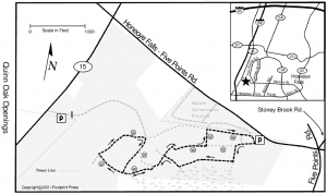
 Rush OOSUA is said to be the only intact Oak Openings in New York State. Numerous trails abound (some marked and some not) in the Oak Openings parcels. Climbers, Tourists and Naturalists groups will each enjoy their own traverse in the Oak Opening parcels. Climbers – will make it to the NY Rt 15 western side of the parcel and traverse many more trails as well. Tourists – will find numerous opportunities for stopping to take a look and continuing on as they wish, for a mixed opportunity hike length between that of Climbers and Naturalists. Naturalists – Gene will be Hike Leader and wield his Field Manuals as Interpreter for this 1-2 mile hike with lots of nature looking (and likely some mushroom hunting, so you may want to bring paper bags, and perhaps a small digging tool, for collecting mushrooms). Overall the OOSUA area is generally flat with rollings hills and max elevation changes of 50 feet or so from one area to another. You can see some of the trails on this map from Footprint Press.
WHERE & WHEN TO MEET & ABOUT PARKING AND ACCESS: For our Sunday October 6, 2013 2:00PM scheduled hike, we will all be gathering at the Honeoye Falls Five Points Rd access site (at the NYSDEC “Quinn Oak Openings” sign) on the south side of the Honeoye Falls Five Points Rd just 0.2miles (1000 ft) west of the intersection with Five Points Rd. Click for directions.
Note that similarly named “Honeoye Falls Five Points Rd” and “Five Points Rd” are NOT lengthened or abbreviated name versions of the same road, they are different roads which cross at “Five Points” intersection. (Stony Brook Rd is the fifth road, creating 5 points). And of course, the “6″ in Honeoye Falls 6 Rd to the south has nothing to do with 5 Points. All roads approaching the OOSUA area are paved roads. The OOSUA driveways are gravel and dirt.
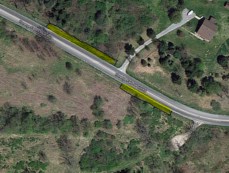
 The parking lot is small, (about 6 cars) and parking in the lot may be tricky in inclement weather, with the steep odd angled downhill entrance. We might recommend 4WD for cars parking in the parking lot if it has rained a lot prior to our hike. Others can park on road shoulders to the west of the parking lot. Stay on the south side of the road if east of the driveway across the street and on the north side if west of that driveway. (See the highlighted areas in the image to the right). —Bear in mind there may be vehicles in the lot belonging to bow hunters, so do not block any cars in unless you have owner consent.
FACILITIES – this is an “unimproved” location with exception of the parking lots, NYSDEC sign and trails (some of which are official and marked). There are no restrooms or porta-potties here nor water faucets, electricity, benches, etc.
For those interested in Carpooling from Springwater: an unsupervised carpool will be formed at Springwater Town Hall at 1:00 PM. Plan on leaving promptly at 1:10 PM. Directions to the hike and to the social are available here.
AFTER-HIKE SOCIAL
Our optional after-hike social will be at the Avon Tom Wahl’s Restaurant outdoor picnic pavilion, located behind Tom Wahl’s restaurant in Avon. Contribute to a picnic (we encourage bringing a pot luck dish to share) and/or choose from the Tom Wahl’s menu of sandwiches, fries, soup, shakes, ice tea, soda, ice cream, etc. For frugal gourmet hikers, coupons for discounts on various menu items at Tom Wahl’s Restaurant in Avon (283 East Main Street) can often be found on-line, in phone books and in newspapers. A “buy-1 cheeseburger get-1 free” can be printed or brought on your smart phone. Tom Wahl’s also accepts Bill Gray’s coupons.
I redundantly state for those of us unsure about this – At the outdoor picnic pavilion, in addition to food and beverage we purchase at Tom Wahl’s, we ARE permitted to bring in outside food, so think picnic grand style, the best of both worlds (patronize Tom Wahl’s and bring homemade too), … and of course there is access to restrooms in the restaurant. If Tom Wahl’s parking lot is full, there is a Tops Grocery store plaza across the street for parking and also parking at a plaza with CVS,Dollar General and other stores immediately west of Tom Wahl’s. (Wow, you may take opportunity to get some shopping done after the social.) The picnic pavilion tends to be a bit busy on nice weather weekends, but I have been assured our group of hikers can be accommodated no problem.
SOME ADDITIONAL INFO
Our October 6th hike day is the first Sunday of Bow Hunting season, so hikers are encouraged to wear some orange (or bright pink or red) for safety throughout much of our Fall Hiking Season. Bow hunting is allowed at NYSDEC OOSUA but we expect little to no encounters with Bow Hunters. On the adjacent The Nature Conservancy “Rush Oak Openings Preserve” hunting is not allowed.
Also of note: dogs ARE allowed on the NYSDEC parcel (228 acres), but are NOT allowed on The Nature Conservancy Preserve (11 acre) parcel.
—– Back in March we saw that, due to the “Bush Hog” type mowing done on many trails in the OOSUA parcel and on TNC Rush Oak Openings preserve trails, vegetative stubble about 3 to 6 inches in height is the surface of an substantial number of trails. Some of the stubble looks prone to puncture through soft soled rubber boots. I suspect similar conditions in October, so I suggest hiking boots or some type of harder soled footwear.
Note – for those hikers who back at the March 2013 hike found a lot of gun fire activity at the adjacent Rochester Brooks Gun Club, as Hike Planner my apologies that some were bothered by it. Unbeknownst to me there was a major organized shooting event on that day. I have checked on Oct 6, 2013 and been assured there is no organized event at that neighboring property, so while some gun fire will likely be heard from regular target/trap/skeet shooting by club members, it should be no where near the amount heard back in March.
I believe we have “passport booklets” for the “Passport to Family Wellness” program (part of the “Eat Well, Live Well Challenge”) for hikers who wish to participate in that Passport Program sponsored by Wegman’s Food Markets – you will want the passport booklet for the Nature Conservancy Preserves. The Passport booklet provides page space for trail marker rubbings with a pencil or crayon, which indicate that a hiker has been to that location.
Description submitted by Don
