
Add to Calendar
When:
August 4, 2024 @ 4:00 pm – 6:00 pm
2024-08-04T16:00:00-04:00
2024-08-04T18:00:00-04:00
Please join us for a Stid Hill hike on Sunday Aug 4th at the 6405 Dugway Road trail head. Meet at 3:45 for a 4pm start time. The Stid Hill Multiple Use Area is a 847 acre tract of land situated in the townships of Bristol and South Bristol in Ontario County. It is bounded by Route 64 on the west and Dugway Road on the north. Mud Creek, flows along Route 64. At one time, Stid Hill was productive sheep and cattle grazing land. Today the grazing has been eliminated. The mixture of steep hills, ravines, gullies, gorges, woods, and open areas create scenic vistas and also provide varied wildlife habitats.
Tourists and Naturalists: For the Tourists and Naturalists, they will do a 2.5mile loop from the Red trail to the Blue and Yellow trails, then back to where they started from on the Red trail. There is one steep climb towards the beginning (just take your time). This hike takes us through mostly woods, various types of plants, right by a lonely rock and of course, the famous old truck. Poles are a good idea.
Climbers: The Climbers will hike about 4 miles in a larger loop starting off with the Naturalists, then down around Lower Blue, hitting several steep areas and finally back up to where they started. Poles might come in handy.
The Social: We’ll go to Lock Stock and Barrel on Route 64 just north of Bristol Mountain (5436 State Route 64) for the social after the hike.
Directions:
From the north, (Honeoye and Bloomfield) starting at Route 5 & 20 in Bloomfield, come down Route 64. 3.0 miles south of Rt 20A and 1.4 miles past Bristol Center (and CR 32), turn left on Dugway Road. The Stid Hill MUA parking area will be about 2 miles up on the right.
From the south, starting at Bristol Springs for 6.4 miles, come up Route 64 past both Stid Hill parking areas, then turn right on Dugway Road. If you come to Bristol Center you’ve come too far north.
From Springwater, Head north to 20A through Honeoye, then south on 64(see north directions above).
From Wayland, the recommendation is to take Rt 21 through Naples to the east end of Dugway Rd (4.5 miles north of the intersection with NY 64). The trail head is 1.2 miles west on Dugway, (Dugway is paved to the Bristol/Canandaigua town line).
Trail Maps:
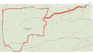
NATURALISTS
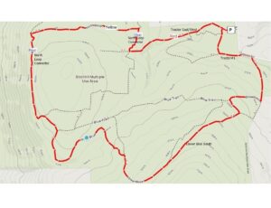
CLIMBERS