
Hornell
NY 14843
USA
 Last Sunday’s hike (Oct 18th) was on old railroad lines, and was nice and flat. So watch out, this Sunday we will be doing a hike that is anything but flat. Although not a technically difficult hike, this will be a strenuous hike for each of the hike levels. For steep downhills, walking poles will provide some appreciated extra stability.
The hike will start an an elevation of 1600ft to the east of Hornell and will climb to 1800 over the first half mile. Views should open up here at the top, allowing us to look north toward Wayland and Springwater, before starting down to 1200ft over about 2 miles. After crossing the road and Big Creek (Its name on the maps, and an accurate name too), the Climbers will have an opportunity to earn their name over the final mile and a half with a climb up to nearly 1700ft and back down to the cars.
This hike will be a one-way hike, which means some shuttling cars and car-pooling. Although all groups will walk the same trail, we will start and end at different points to allow for different length hikes. In an attempt to simplify the car shuttling and to save some gas, we will all meet at the Wayland Parking lot behind the firehall at 1:00PM (leaving promptly at 1:15).
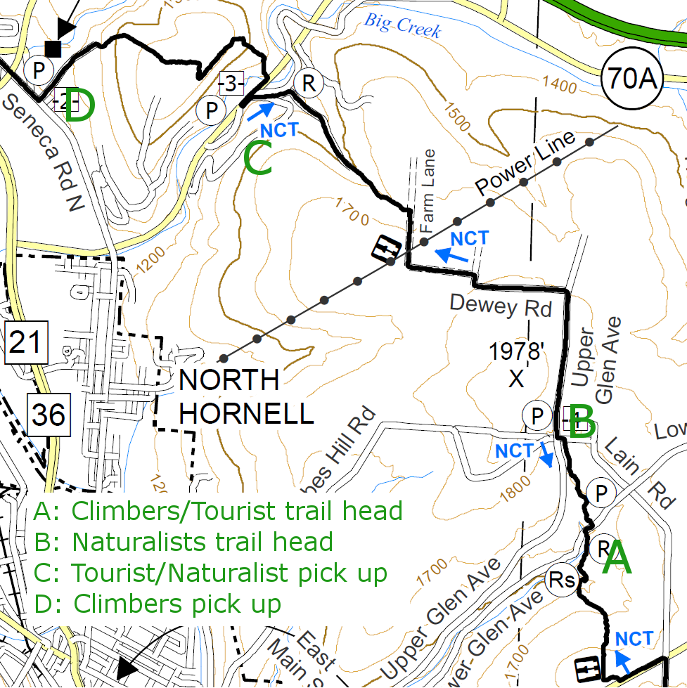 Climbers will leave some cars at the Econo Lodge (D) in North Hornell (7462 Seneca Rd N, Hornell, NY) which will be the end of the hike. From there, we will car pool to Lower Glen Ave (A) to start the hike.
Tourists and Naturalists will leave some cars on Big Creek Rd (Steuben CR70A) opposite Beltz and Patton Roads (C), which will be the end of their hike. From there we will car pool to Lower Glen Ave (A) where the Tourists will start their hike. The Naturalists will then drive to Laine Rd and Upper Glen Ave (B) to start their hike at the high point of the trip. The Naturalists and Tourists will meet on the way down to CR70A and their cars.
The challenge will then be to find all of the cars we have left at the start of the hikes. Gene will be in charge of that!
Following the hike, we will visit a restaurant in Hornell for dinner and to review the hike. Please come with ideas for Winter hikes since it is time to start that planning.
Directions:
All Hikers to meet at Wayland Parking (42.568606, -77.590562):
Plan to be at the parking area at 1:00. We will distribute maps and select cars for carpooling. We will leave at 1;15 for Hornell. Please be on time. If you can’t make the parking lot by 1:15, you can try to meet us at the trail head on Lower Glen Ave.
From Springwater: Head south on NY-15 to the light in Wayland. Turn right on Rt 63 (W Naples St). In about 150ft, turn right between the Fire House and the Sugar Creek building to get to the parking lot in the center of the block.
From Dansville: Head east on Rt 63 toward Wayland. Just before the second light in Wayland (at NY-15) turn left between the Fire House and the Sugar Creek building to get to the parking lot in the center of the block.
From Naples and N Cohocton: Head west on NY-21S toward Wayland. Go through the light at NY-15. In about 150ft, turn left between the Fire House and the Sugar Creek building to get to the parking lot in the center of the block.
Carpool directions to Hornell:
To Econo Lodge (42.363603, -77.666032): End of Climbers hike.
From Wayland: Exit from the parking lot next to the Fire Department. Turn left on Rt 63, then right (south) on NY-15/NY-21. Stay on NY-21S for 18.5 miles. At the stop sign, turn left onto Seneca Rd N. Take the second left onto Filter Plant Rd.
To Big Creek Rd and Beltz Rd (42.363675, -77.648883 ): End of Tourist/Naturalist hike.
From Wayland: Exit from the parking lot next to the Fire Department. Turn left on Rt 63, then right (south) on NY-15/NY-21. Stay on NY-21S for 18.5 miles. At the stop sign, turn left onto Seneca Rd N. In 0.9mi turn left onto CR 70A (Big Creek Rd). After 0,9 mi, turn right on Patton Rd and immediate left onto Beltz Rd.
To Lower Glen Ave: (42.336779, -77.620044): Trail head Climbers/Tourists
From Wayland: Exit from the parking lot next to the Fire Department. Turn left on Rt 63, then right (south) on NY-15/NY-21. Stay on NY-21S for 18.5 miles. At the stop sign, turn left onto Seneca Rd N. In 3.4mi turn left onto Main St for 0.5mi. Turn left onto Tobes Hill Rd, then an immediate right on Florence St which becomes Glen Ave after the left corner. In about 0.6 miles, take a slight right onto Lower Glen Ave. The road will cross the creek three times. At the third crossing, look for signs for the Finger Lakes Trail and the North Country Trail. There is shoulder parking available. If you get to Laine Rd, you have gone too far.
From the Econo Lodge: Turn left (south) onto Seneca Rd for 2.5 miles. Turn left onto Main St for 0.5mi. Turn left onto Tobes Hill Rd, then an immediate right on Florence St which becomes Glen Ave after the left corner. In about 0.6 miles, take a slight right onto Lower Glen Ave. The road will cross the creek three times. At the third crossing, look for signs for the Finger Lakes Trail and the North Country Trail. There is shoulder parking available. If you get to Laine Rd, you have gone too far.
From Big Creek Rd (CR 70A) and Beltz Rd: Head Northeast on CR 70A for 2.3 miles. Turn right onto Butchers Corners Rd CR 56. Take the first right onto Hungry Hollow Rd and the next left to stay on Hungry Hollow Rd for 1.5mi. Make a sharp right onto Middle Rd (Lower Glen Ave). After crossing Laine Rd, head down the hill (about a quarter mile) and look for Finger Lakes Trail signs at the creek crossing.
To Tobes Hill Rd, Laine Rd and Upper Glen Ave Intersection (42.342806, -77.622447): Trail head for Naturalists.
From Lower Glen Ave trail head: Head east up Lower Glen Ave. Turn left onto Laine Rd. There is shoulder parking at the intersection with Upper Glen Ave and Tobes Hill Rd.