
Hikes led by Springwater Trails are generally held on Sunday afternoons and appear in this calendar in green.

*** PLEASE NOTE – – – This is NOT a scheduled Springwater Trails hike. It is an option for a hike at Watkins Glen, a hike led by a park naturalist, as held on numerous dates. Sunday August 9th (when there is no scheduled S/T Sunday hike) being one of those dates.. ***
Likely Watkins Glen is a bit far to do a S/T hike, perhaps except by distance exception. (On the outer reaches of travel area to hike.) However for those S/T hikers with specific interest in going to Watkins Glen S.P., recently rated #3 state park in the U.S.A. (by-the-way Letchworth S.P. was recently rated #1 state park in all of the U.S.A., maybe you’ve not yet heard this), &/or who are perhaps looking for a Sunday 8/9/2015 hike (if they feel they are missing a Sunday hike from their weekend plans) and who maybe can not make the Saturday August 8th S/T hike this may be an option.
There are also other dates for this same “Walk Behind the Waterfalls Gorge Tour” hike. Please take note of the varying availability of dates and times this hike is offered as a park naturalist guided nature walk.
Perhaps at the Saturday 8/8/2015 S/T hike (Canadice Outlet Woodswalk), some of our S/T hikers may wish to confer about possibilities of coalescing a group of hikers who may wish to hike at Watkins Glen on 8/9, or on another date, to do this Watkins Glen Waterfall hike.
And, … of course once you are at Watkins Glen S.P for this hike, nothing stopping you from continuing your hiking time at the park outside of the park naturalist guided walk. Heck, you made the drive, why not see some more of the place. And if it is a hot day, there is an olympic-sized swimming pool in the park sure to cool you off if you take the plunge. And for cemetery appreciators (and with a vista viewpoint none-the-less), there is a large cemetery (Greenwood Cemetery) immediately contiguous the northeast section of Watkins Glen State Park, and yes park trails connect to the cemetery. It is left to you to explore the possibilities, no “spoiler” here, albeit said there is an open-sided pavilion in the cemetery with picnic tables.
Also noteworthy, not too far west of the far western end of the park, is a section of the FLT, and in the towns of Orange, Tyrone, Reading & Dix (all in Schuyler County) is the Sugar Hill State Forest and here you will find the Sugar Hill Fire Tower trails, and YES, you can climb the fire tower to the top. And occasionally the “cab” of the fire tower is open. (Hint: look for Tower Hill Road.)
——————————————————————————————————————-
Here is the listing info provided on the park website for this recurring date hike.
http://nysparks.com/events/event.aspx?e=142-14059.5.7
Walk Behind the Waterfalls Gorge Tour
Daily Dates through: Tuesday, September 8th, 2015, inclusive (No hikes SCHEDULED ON mONDAYS)
Join a park naturalist on a guided nature walk one mile up the Gorge Trail to explore the origins and history of the gorge. Meet at the gorge entrance at the end of the main parking lot off of Franklin St./NYS Route 14.
Tuesdays – Sundays, 10am & 1pm. No fee; no reservations required.
– See more at: http://nysparks.com/events/event.aspx?e=142-14059.5.7#sthash.REqLupxe.dpuf
Saturday, April 23, 2016 at 10:00AM , this will be a short hike, with lots of history about the CCC Camp at Big Bend in Letchworth State Park. The announcement, states: 3 hour, moderate walking 1/2mile, bring a lunch. At 10:00AM, the “meet locale” is at Parade Grounds parking lot, and then there will be a carpool to the event site (the Big Bend CCC Camp).
This event is offered thru the Letchworth State Park hike and activity series. A very active series that holds numerous hikes and other activities year round, mostly in Letchworth State Park and on the Genesee Valley Greenway State Park (aka GVG -or- GVGSP). These events are published in The Genesee Naturalist published quarterly.
This event is led by Historian and author Tom Cook, author of a book about the Letchworth Park CCC Camps, and author of other books as well.
Also of note, Tom Cook will be presenting the Avon Preservation and Historical Society (APHS) program about the Genesee Valley Canal (GVC) during which he will particularly highlight the challenging area of canal construction in and surrounding present day Letchworth State Park. This APHS program is scheduled at 2:00PM on Sunday April 24th, 2016 at the Avon Opera Block second floor meeting room (handicap accessible) located at 23 Genesee St in the Village of Avon (off the west/southwest side of the traffic circle in the Village of Avon that Routes 5&20 navigate through.
Following this presentation, Springwater Trails will be holding a hike (hike meet at ~3:15PM or so) on the former GVC corridor (now the Genesee Valley Greenway State Park aka GVGSP -or- GVG). This Springwater Trails hike will be on the GVG (spanning miles 12-17 of the GVG) in town of Caledonia which is just across the Genesee River from Avon. Various length hike groups are planned for on this hike, the shortest of which is suitable for mobility limited hikers (inclusive of wheelchair hikers).
The bald eagle has been chosen as the national symbol of our country. A pair, of these magnificent birds, has built a nest near the top of a tree south of Bath and, every year, since they built it, they have been returning to raise a brood, usually consisting of 2 chicks. In Mossy Bank Park, a hill, above this tree, offers a great vantage point to view the nest from above. Last year, we went there in early May and had a good look at the fuzzy chicks in the nest. This year, the parents have returned to the nest and, 2 chicks have successfully hatched. This time, we’re going back, later in the month, the chicks will be more mature and, if we’re lucky, we may see them walking around the nest.
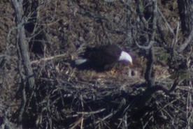
The Mossy Bank Park eagle feeding her chicks
May 2, 2015
– by Brenda Todd
Once again, Dr. Randy Wiedner, has offered to be our guide for this day. We will meet at 2 PM, at the nature center. Then, Randy will lead us to the eagle viewing ledge. Although he’ll set up a spotting scope for us, if you have binoculars, you’ll want to bring them for this one. After our view of the eagles, Randy will lead a hike through the trails of the park. For those preferring a slower pace, I will take you on some of the trails along the ridge and point out some of the features we encounter.
After our hikes, I have reserved one of the park’s pavilions, for a pot luck picnic. Randy, and his wife, Cathy, will join us as our guests. The rest of us need to bring a dish to pass, and beverage, or make a donation. After you’re done feeding your face, don’t run away. Make your way to the nature center, where Randy will show us his great bald eagle powerpoint. Besides seeing the history of this pair at this tree, you’ll see how our great national symbol was threatened with extinction in the mid 20th Century and the comeback that it made, due to the efforts of the late Rachel Carson, and other such heroes. You don’t want to miss this one. And, because it’s late May, it will still be light when you make your way home.
Go south on I-390 and east on I-86. Take exit 38 and go left at the end of the exit ramp. Go under 86 and turn right at the first traffic light, onto W. Morris St. Go past Tops, stay right at the fork, go past the library and make a sharp right onto Cameron St. Pass 86 again, and the Cohocton River and continue 1.6 miles. Watch for small Mossy Bank Park signs and fork to the left onto Windfall Rd. Go .4 miles and turn left onto Mossy Bank Park Rd. Go 1.3 miles to gate, marked with a small sign. Continue straight ahead until you pass between 2 large boulders, into the park. Park in the parking lot and come to the nature center.
Hosted by the Finger Lakes Land Trust
 Join preserve steward and naturalist Eric Cosman for an exploration of the birds, plants, trees and other natural wonders at the Wesley Hill Preserve. Diverse stands of mature forest, a wide array of wildflowers, and sweeping views of the hills surrounding Honeoye Lake’s southern end make this site truly special. Don’t forget to dress for the weather and be sure to wear shoes you don’t mind getting wet.
 Directions: Meet at the Wesley Road entrance! From Honeoye, take Rt. 20A east to East Lake Road. Follow East Lake Rd. south for a short distance and then turn left on County Rd. 33. Continue a short distance and turn right on Pinewood Hill Rd. Follow Pinewood Hill, then Gulick Road south for approx. 2.5 miles. Turn right on Wesley Road and follow approx. 1 mile to the parking area on the left.
Look for other events sponsored by the Finger Lakes Land Trust on their website.
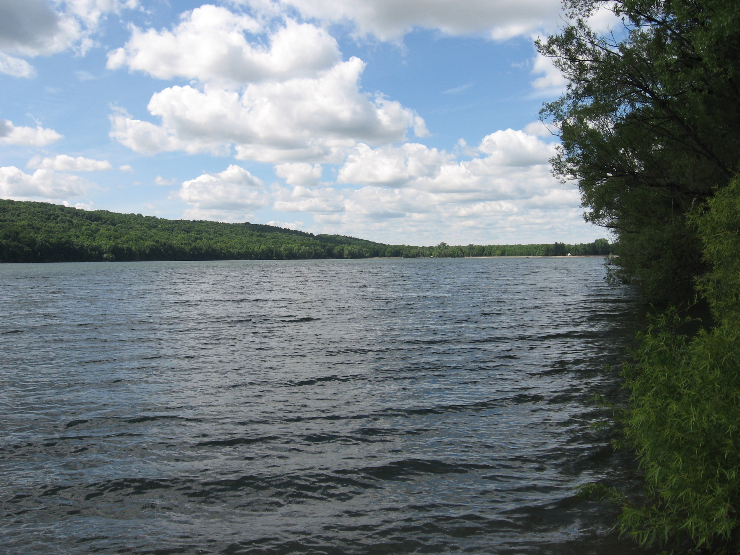
Viewing the west shore of Hemlock from the north boat launch.
After the history program at the Jack Evans Community Center, Springwater Trails will lead a shortened hike along the west side of Hemlock Lake. We will take some time to view the old cottage foundations along the trail.
This will be an abbreviated hike, lasting about one hour. The trail is intended to be level, but creeks that have washed out parts of the trail will require some careful climbing. We may also venture out on the shoreline, to take advantage of the lower water level of the lake.
A chicken BBQ will be available before the history program at 12:30. We will not have a social following the hike.
Directions:
From The Jack Evans Community Center: Head south on NY-15A for 0.9 miles. Take the first right turn onto Rix Hill Road. Park near the Kiosk on the left on the far side of Hemlock Lake.
From Springwater: Go north on NY-15A for 10.1 miles from the light in Springwater. Turn left at the north end of Bald Hill onto Rix Hill Road. Continue on Rix Hill Rd past the Hemlock Lake Park to the Kiosk on the west side of Hemlock Lake.
This Sunday, come back to a familiar hike for Springwater Trails, and see the changes that have taken place. The first thing that regular Springwater Trails hikers will notice is that the town has paved Schribner Rd. For those of you nostalgic for the old road, check out the summer directions and come in the back way.
The Climbers will be following logging roads up to the top of the hill. We then will cross the fields to explore various views across the valleys. The Tourists will take a bit more time climbing the hill. The new logging trails go across the hill, giving hikers some respite from the climb and a change to view more of the forest. And the Naturalists will follow a more level trail through the White Pines, then up to the Red Pines and then will cross the valley to see the Oaks, Maples and Beach forest.
Following the hikes, join us for a Dish to Pass social at the house. Depending on the weather, we will have the option of being outside for the last social before the end of Daylight Savings.
Directions:
From Springwater: Head north on Rt 15A from the light in Springwater. Take the first right on Wheaton Hill Rd (Co Rd 16). Turn right on Wetmore Rd at the stop sign at the top of the hill. At the end of Wetmore, bear right on Tabors Corners Rd. After 3.5 miles turn right on Scribner Rd. (There is no road sign at Schribner, but this is the first right off of Tabors Corners Rd.) The driveway is the 2nd driveway on the left one mile up Schribner Rd and about 10 feet before the intersection with Giles Rd. Turn around at the intersection and park on the west side of Giles Rd.
From Wayland: From Rt 15, head east on Rt 21 toward North Cohocton for 3 miles. Turn left on Tabors Corners Rd (Steuben Co Rd 37). (Note the road sign says Bowles Corners, although maps all say Tabors Corners) After exactly 2 miles, turn left on Schribner Rd (the second left – again, no street sign). The driveway is the 2nd driveway on the left one mile up Schribner Rd and about 10 feet before the intersection with Giles Rd. Turn around at the intersection and park on the west side of Giles Rd, or come in the driveway and park on the grass near the barn.
From Honeoye: From Rt 20A, head south on Ontario Co Rd 37. At Canadice, continue straight ahead on Canadice Hill Rd as Co Rd 37 turns right. Bear to the right onto Ross Rd. Take the first left turn onto Tibbles Rd (formerly Springwater Town Line Rd). At the end, turn right on Wetmore Rd. Stay on Wetmore up over the hill to the end. Bear right on Tabors Corners Rd. Take the first right in 3.5 miles on Scribner Rd (sorry, no street sign). The driveway is the 2nd driveway on the left one mile up Schribner Rd and about 10 feet before the intersection with Giles Rd. Turn around at the intersection and park on the west side of Giles Rd, or come in the driveway and park on the grass near the barn.
From the East Lake Rd in Honeoye or From Naples: Rather than traveling north to reach 20A or Co Rd 37, hikers from east of Honeoye Lake may go south to Ontario Co Rd 36 and follow Co Rd 36 to Naples. Turn right on Rt 21 south. Turn right to stay on Rt 21 for 4.5 miles to N Cohocton. Turn right to stay on Rt 21 towards Wayland. After 3.8 miles turn right on Tabors Corners Rd (Steuben Co Rd 37). (Note the road sign says Bowles Corners, although maps all say Tabors Corners) After 2 miles, turn left on Schribner Rd (the second left) (Again, no street sign). The driveway is the 2nd driveway on the left one mile up Schribner Rd and about 10 feet before the intersection with Giles Rd. Turn around at the intersection and park on the west side of Giles Rd, or come in the driveway and park on the grass near the barn.
Hike Description
We will hike the FLT Bristol Hills Branch Trail (Map B3) to Huckleberry Bog and the Bog Nature Trail Loop. This upland bog is located on a plateau west of Keuka Lake in Urbana State Forest, Steuben County.
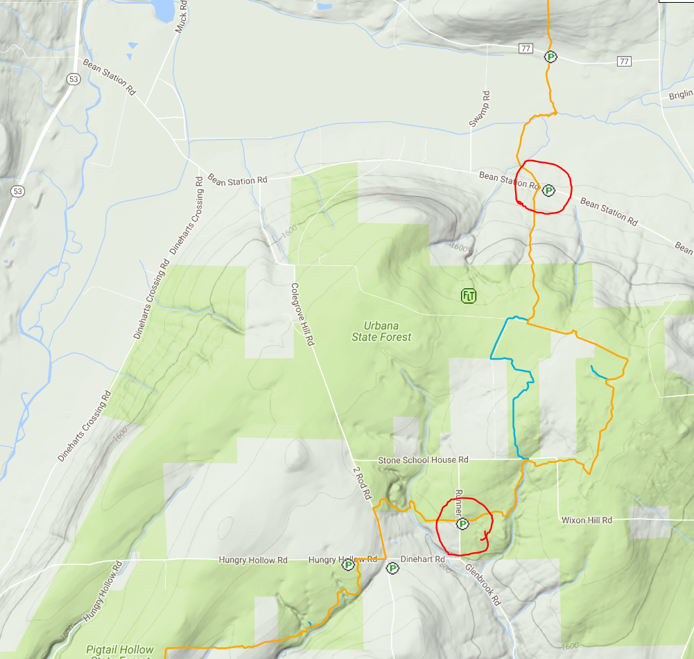 Climbers will start from the trailhead at Bean Station Rd and take the trail past an old cemetery and climb steadily uphill through a hemlock and oak woods to the state forest and onto the top of the plateau. Climbers will then follow the Bog Nature Trail Loop clockwise and return to Bean Station Rd by way of the main trail (4.5 miles).
Tourists and naturalists will start at a higher elevation from the access at Glen Brook Rd and take the trail northeast to the southern register of the Bog Nature Trail Loop. Tourists will go around the Bog Nature Trail Loop and return to Glen Brook Rd (~3.5 miles). Naturalists will retrace their steps back to Glen Brook Rd (~ 1mile).
Directions to Meeting Location for All Groups
From Springwater: Head south on NY 15 to Wayland. Turn left onto NY 21, Turn left in N Cohocton to stay on 21 into Naples. Turn right onto NY 53. Stay on 53 for 13 miles. At 10.4 miles on your trip odometer, you should pass through Prattsburgh. Follow the directions below.
From Prattsburgh, take NY 53 South for 2.6 miles to Bean Station Road. Turn east on Bean Station Road at the site of a large white warehouse for onions. Go 2.6 miles to the yellow trailhead sign on the right (south) side of the road at a little footbridge over the roadside ditch. Park on the opposite shoulder but not on the lawn or pull inot a small mowed spot marked “FLT Parking” about 200 feet further east, on the left (north side of the road). After breaking into groups, tourists and naturalists will caravan to the Glen Brook trailhead.
From Geneseo and Dansville: Take I-390 South to I-86East. In 1 mile,take exit 37 for NY-53. Turn left onto NY-53 and head north for 8.9 miles. Turn right onto Bean Station Road. Continue with the directions From Prattsburgh.
Car Pool
Car pooling is recommended. You can set up your car pool ahead of time or meet at the parking lot for the Mountain View Inn at 12:30.
After Hike Social
The after hike social will be at the Mountain View Inn, 34 Main Street, Atlanta.
An update as of 3:00 Saturday
Waterproof Boots are highly recommended.
There are a number of streams we will need to cross on Sunday. You will be in about 2 to 3 inches of water.
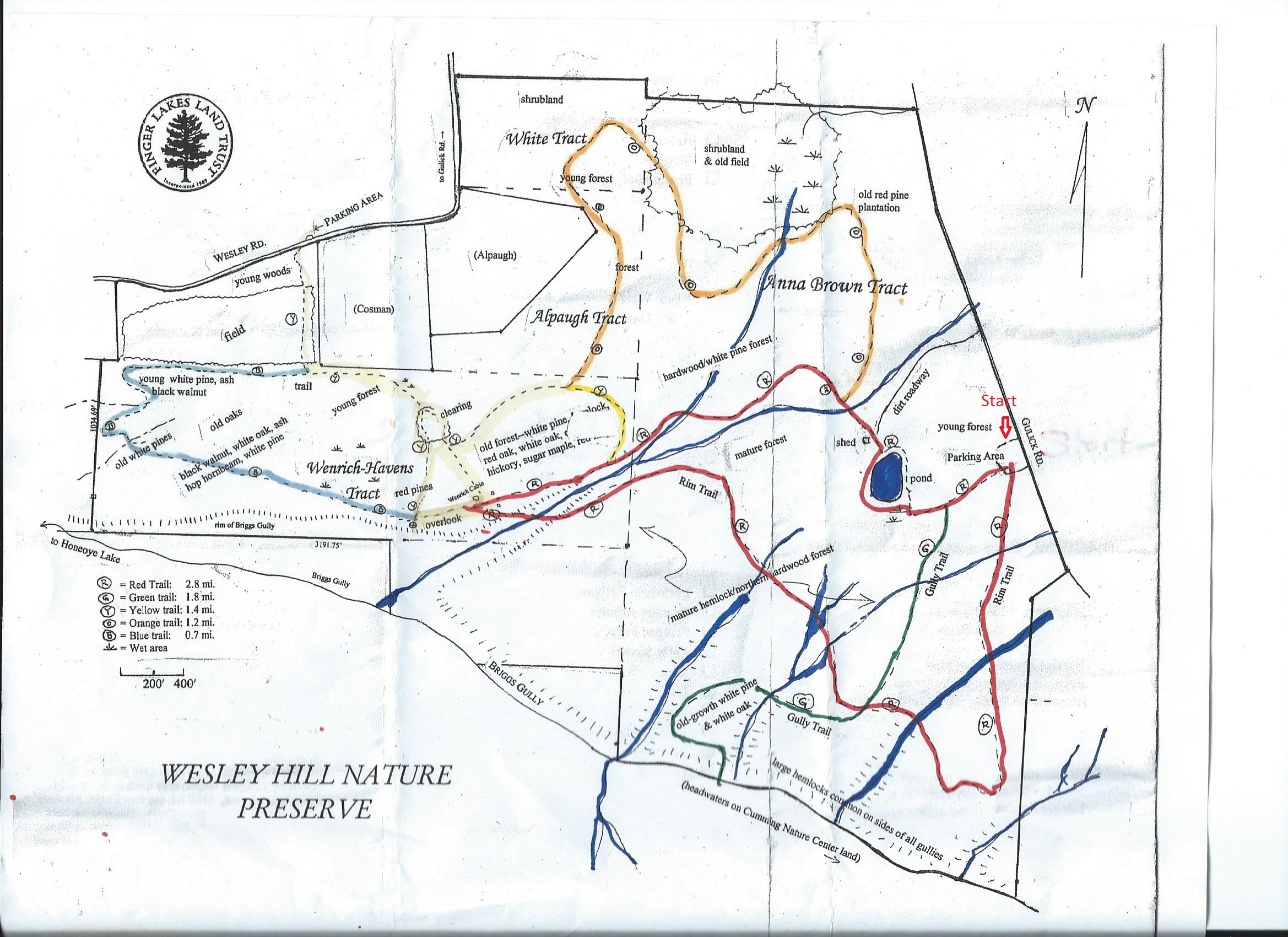
This week we will hike the Wesley Hill Nature Preserve which was founded in 1999 by the generous donation of 90 acres by the children of three artists- John Weinrich, James Havens and Colburn Dugan to the Finger Lakes Land Trust. Since that time the preserve has grown to over 390 acres by the way of the purchase, by the land trust, of three parcels and a gift of the fourth. Click on the trail map to the right if you want a larger trail map.
We will all meet at the preserve parking lot, on the west side of Gulick Road at 1:45 pm.
In case of snow or muddy trails, please wear correct footwear. Crampons and poles will be helpful.
Climbers led by Charlotte will follow the Red trail on the right of parking lot to Green Trail down to the Gully and back on the Green trail to the Red trail to the left to the cabin and past the pond and back to parking lot. 4+ miles
Tourists led by Nanette will follow Red trail on the right of parking lot to the cabin, past the pond and to parking lot. 3 miles
Naturalist led by hiker will follow the Red trail to cabin and back to parking lot. 2 miles
Our social will be at Honeoye’s Boat House (Trident Marina) on 5226 East Lake Road, Honeoye 14471. Was voted as one of the best in five Happy Hour Bars in the Rochester area.
A word of caution – do not try to access Wesley Road from down on East Lake Road, in spite of what your gps might tell you. The road is closed from East Lake Rd up to the Wesley Road Trail Head. If you try it you will readily see why.
From Honeoye: take route 20A east through Honeoye to East Lake Road (CR 33). Turn right onto East Lake Road. (If coming from Bristol or points east, its a left onto East Lake Road). Take the first left, staying on CR 33, then the first right onto Pinewood Hill which becomes Gulick Road. Wesley parking lot is 4.3 miles down Gulick, on the right side.
From Springwater: Head north on Rt 15A toward Hemlock. Just before Hemlock, turn right on Rt 20A. Follow Rt 20A east through Honeoye to East Lake Road (CR 33). Turn right onto East Lake Road. (If coming from Bristol or points east, its a left onto East Lake Road). Take the first left, staying on CR 33, then the first right onto Pinewood Hill which becomes Gulick Road. Wesley parking lot is 4.3 miles down Gulick, on the right side.
From Naples: From the southern end of Naples, head west on Co Rd 36. Follow Co Rd 36 for 1.2 to the first right turn on Gulick Rd. Follow Gulick for 7.5 miles. Wesley parking lot is on the left side.
Directions to the social: Turn left out of the parking area and head north on Gulick Rd for 3.3 miles. The road bears left and becomes Pinewood Hill Rd. At the stop sign, turn left to stay on Pinewood Hill Rd (CR 33). In 0.4 mi, turn left onto E Lake Rd. In 0.8 miles, turn right onto Deyo Dr at the sign for Trident Marine. The Honeoye Boat House Grill is about 150 feet down toward the lake.
[envira-gallery slug=”wesley-hill-preserve-winter”]
The Finger Lakes Trail from Naples to Conklin Gully
The Sunday hike on December 11th 2016 will cover several trails on Hatch Hill in Naples. The hike will start at the Bob North bridge at the bottom of Ontario Street in Naples. There is a small parking lot there, and all groups will start at the same place. The naturalists will walk along Matt’s Meander to the Naples Community Park and back, while the Tourist will walk south along Hatch Hill above the town to the south end of Naples. The Climbers will walk north on Hatch Hill to Conklin Gully. Both Tourists and Naturalists will walk back to the parking lot, while climbers will end up at the DEC parking area at the bottom of Conklin Gully and be shuttled back to Naples.
There is a DEC display board at the parking lot with a map of all the trails that meet there; all the day’s hiking trails are shown.
The social will take place at the Neapolitan Pizzeria in downtown Naples.
Naturalists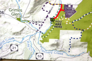

The Naturalists will cross Naples Creek on the Bob North bridge and bear to the left. It is a broad path through woods with the Naples Creek flowing to the left of the path. This trail is called “Matt’s Meander”, and it follows Naples Creek to the Community Park on Route 245. It is about a mile to the end of the trail and back.
Tourists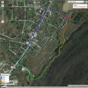

The tourists will cross the bridge and bear to the right. The trail runs south along Hatch Hill above Naples Creek, and goes parallel to both Naples Creek and Naples Main Street, though a lot higher up the hill. This path is not blazed or marked at all but it is well trodden for most of the way; it becomes a little harder to see at the southern end, but once the Turkey Federation parking lot is in sight then it’s not hard to find a way down to it. The trail passes through land that was once grazed and then terraced for vines, but is now returning to woodland. Traces of the shallow terracing for the vineyards can be seen all along the trail, and occasionally an abandoned farm building. The creek can be seen in the valley below the trail all the way along. This trail ends at the south end of Naples, on Mark Circle, where several streams come together to form the Naples Creek. There is water supply facility there, a swimming hole, and an antiques shop. The group will return to the Ontario Street parking lot via Naples Main Street. This walk is 2.1 miles. with just one short modestly steep section.
Climbers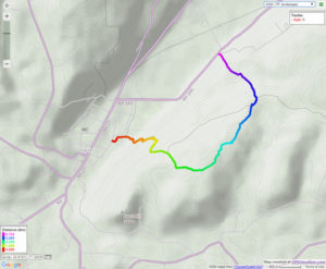
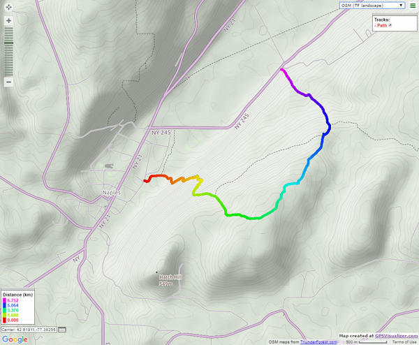
The Climbers will take the Finger Lakes Trail to Conklin Gully through the High Tor Game Management Area. They will cross the bridge and bear left along with the naturalists, and then about half way down Matt’s Meander the FLT branches off to the right. The group will follow the ORANGE blazes on a long uphill section; it’s steep in places with some switchbacks – the trail seems to be going the wrong way at times. There are some ponds at the top of the hill (it’s a mystery – where does that water come from?) with the Howard Beye memorial bench on one of them. It’s important to stay with the orange blazes here – there are several logging roads that make it easy to take the wrong path. Where the trail meets the top of Conklin Gully there is a lookout with a fine view of the Naples Valley and a well organized scout camp, complete with fire pit. The path down the hill from the camp is broad and easy walking. The group will leave the FLT where it branches off to the right over a bridge to the memory of Tom Noteware and follow the BLUE blazes down the hill to the DEC parking lot at the bottom of Parrish Hill.
Please note; IT’S STILL HUNTING SEASON! Please wear bright clothing, preferable hunter’s orange!
The Meeting Place
We will meet at the trail head parking lot on Ontario Street, Naples, at 1:00pm on December 11th 2016. The climbers will shuttle some cars to Parrish Hill before starting off.
Getting There
From Springwater and Wayland, come south on Rt. 15 to the traffic light at Rt 21. Turn left on 21 and keep going all the way to Naples. Go through the downtown business area and turn right on Ontario Street, opposite the school. Go to the bottom of the hill and the parking lot is on the left.
From Dansville, follow Rt. 63 to Wayland where the road turns into Rt 21; continue on 21 all the way to Naples. Go through the downtown business area and turn right on Ontario Street, opposite the school. Go to the bottom of the hill and the parking lot is on the left.
From Naples, go to the school on Main Street (Rt. 21). Turn down Ontario Street opposite the school, go to the bottom of the hill and the parking lot is on the left.
The Social
The social will take place at the Neapolitan Pizzeria in downtown Naples.
I Love My Park Day (ILMPD) is annually held on the first Saturday of May, a NYS Parks initiative. May 6th 2017 is the the 6th annual ILMPD and there are numerous opportunities in which to become involved on ILMPD. Many NYS Parks have planned activities for ILMPD, and many of the activities are targeted with improvement of the respective park.
Info is available on “Parks and Trails New York” website at a special webpage = www.ptny.org/ilovemypark Information also may be available for some opportunities and activities on the NYS Parks website. (Of note, the www.ptny.org website also holds information on numerous other observances and opportunities that occur throughout the year, all targeted at outdoor areas for recreation, relaxation and enjoyment.)
The three STATE PARKS closest to the homerange of Springwater Trails hikers that have participating opportunities in 2017 are Genesee Valley Greenway State Park (aka GVG), Stony Brook State Park, and Letchworth State Park.
GENESEE VALLEY GREENWAY STATE PARK
FOGVG website (in conjunction with the GVGSP) has posted info about opportunities in the Genesee Valley Greenway State Park for ILMPD 2017. FOGVG Facebook page
A clean-up event in Little Black Creek Park, located off Scottsville Rd along the GVG (Chili, Monroe County), is scheduled at 9:00AM-12:00Noon. There is a former Genesee Valley Canal culvert and waste weir on the GVG in Chili, so there’s an opportunity to learn and view some history at this clean-up event. (Details can be gleaned from the FOGVG Facebook page.)
FOGVG is also leading a hike on miles 80-83 of the GVGSP at 10:00AM May 6th, in Allegany County near the hamlet of Black Creek. (Details can be gleaned from the FOGVG Facebook page.)
STONY BROOK STATE PARK has a participatory event scheduled from 10:00AM-12:00Noon; meet at Clara Barton Shelter near the main parking area. One of the planned activities is picking up of the gorge trail, which seasonally closed Nov 19, 2016. (You can be one of the first this season to traverse the Gorge Trail on this day.) Grounds cleaning, Ball Field improvements and grass seeding are also among some activities.
LETCHWORTH STATE PARK from 8:30AM – 1:00PM has planned the following participatory events. Project/Event Description: Leaf and trash removal, garden cleaning, stone staircase maintenance (Shoveling), Playground maintenance, and invasive plant removal. Meeting Location is at Trailside Lodge. All ages welcome.
These are merely a small smattering of the opportunities to participate in during ILMPD – NYS 2017. – – – If passing through a park admission gate enroute to ILMPD 2017, be sure and inform the staff that you are participating in ILMPD efforts, and ask for directions to the meeting location if you need direction.
Looking for brochure.or mailing list so I can receive it in the mail.
Nothing opens up for mailing list.
There’s all kinds of very bizarre ads and post for viagra and other drugs above on calender page.
Please let me know if there’s a brochure available