
Hikes led by Springwater Trails are generally held on Sunday afternoons and appear in this calendar in green.
| Sun | Mon | Tue | Wed | Thu | Fri | Sat |
|---|---|---|---|---|---|---|
| Hike at Fishers Park, Victor 2:00 pm Hike at Fishers Park, Victor Feb 2 @ 2:00 pm – 4:00 pm 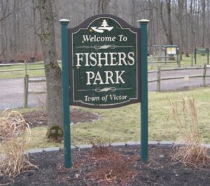 Join us on Sunday February 2nd for a hike around Fisher Park! Located in the hamlet of Fishers, this 93-acre park has a diversity of passive and active recreation opportunities. Visitors can see a multitude of wildlife from deer, squirrels, … Continue reading | ||||||
| Hike at Highland Park/Lamberton Conservatory, Rochester 2:00 pm Hike at Highland Park/Lamberton Conservatory, Rochester Feb 9 @ 2:00 pm – 4:00 pm This Sunday, we will have the pleasure of hiking in Highland Park and or Visiting Lamberton Conservatory in the southeast part of Rochester! George Ellwanger and Patrick Barry donated 20 acres of their nursery grounds, and, in 1888, Highland became … Continue reading | ||||||
| POSTPONED UNTIL MARCH 9: Winter Hike, Ski or Snowshoe-All Western Evergreen Farm, Springwater 2:00 pm POSTPONED UNTIL MARCH 9: Winter Hike, Ski or Snowshoe-All Western Evergreen Farm, Springwater @ Liberty Pole Road Feb 16 @ 2:00 pm – 4:00 pm 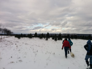 With the Winter Weather Advisory continuing through the day Sunday, Katherine and her advisors have postponed the Christmas Tree hike. Please be safe and drive carefully if you need to be out tomorrow. We will see you next Sunday (check … Continue reading | ||||||
| Hike at Gosnell Big Woods Preserve, Webster 2:00 pm Hike at Gosnell Big Woods Preserve, Webster Feb 23 @ 2:00 pm – 4:00 pm Note, weather dependent, this hike may be moved to Ellison Park, Penfield. Please check back closer to the scheduled hike date to confirm final details. |
 This Sunday we will hike the Middlesex Valley Rail Trail, which runs northeast from Naples, passing through the lowlands of the Hi Tor Wildlife Management Area. The 7.2 mile rail trail is parallel to and north of Route 245, and follows alongside of sections of the West River. We will hike on the section between Parrish Road and Cayward Cross Road, placing cars at several different parking areas along the way to allow for several distances of hiking. The trail is level and wide and slightly downhill, easy walking, though poles will be helpful for any muddy areas.The Middlesex Valley Railroad began service in 1892 between Naples and Stanley, with connections to Geneva, Canandaigua and Wayne County. In 1895 it became part of the Lehigh Valley Railroad system, and continued in service until 1970. Now part of the State-owned Hi Tor area, most of the trail is a raised path with wetlands on either side – some shrubby and some forested. Along the way are waterfowl nesting boxes, and about a mile from the north end is a heron rookery (pictured below).
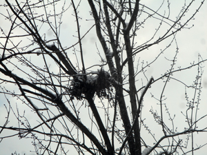 We will meet at 2 PM at the parking lot on the north side of Parrish Road, which runs across the valley from Route 21 (near Monica’s Pies) to Route 245 (near the base of Conklin Gully). We will leave enough cars there to accommodate the return trip for all the Climbers, and will leave enough cars to accommodate the Tourists at the Sunnyside parking lot, along the way to our hike starting point. Everyone will begin the hike heading south from the Cayward Cross Road parking area. Naturalists will hike down the trail as far as the rookery, then return to their cars, a total of 2 to 2.5 miles. The Tourists will hike through the rookery and on to Sunnyside, a total distance of about 3 miles. The Climbers will hike past Sunnyside and on to Parrish Road, for a total distance of about 5.6 miles. The southernmost 1.2 miles of the trail, extending past Parrish Road to Naples, is currently closed due to a bridge outage.Following the hike, please join us for an optional social at the Neapolitan Brick Oven Pizzeria, 120 N. Main St, in Naples.
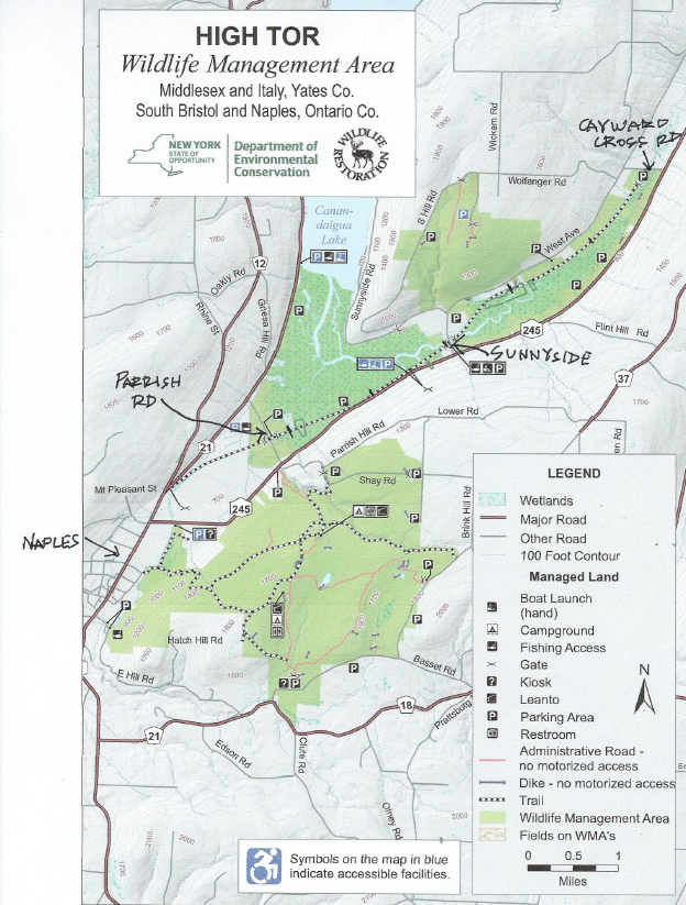
Directions to the Hike Meeting Point:From Springwater/Dansville/Wayland: Take Rt 21N into Naples. Turn left onto Main St for 1.5 miles. Turn right on Rt#245 (across from Bob and Ruth’s). Continue 1.5 miles, make a left on Parrish Rd. Parking area is on the right, in about .2 miles.From Honeoye: Take Rt#36 south into Naples, left on Main St for approximately 1.25 miles. Right on Rt#245 (Across from Bob and Ruth’s). Continue 1.5 miles then left on Parrish Rd. Parking area is on the right, in about .2 miles.
From Canandaigua: Take Rt#21S to Woodville. Keep straight toward Naples. Turn left on Parrish Road about 1.5 miles past Woodville, just after you pass Monica’s Pies. The parking area will be on your left, in about .5 miles.
We have no hike planned for April 20. Please enjoy your friends and family and join us on the 27th.
Join us at the Durand Eastman Arboretum.
Ready to hike some trails that our group hasn’t hiked before? Better bring your camera to this one. Since we’ll be in turkey season, bright attire may be advisable.
This Sunday, we’re going to hike Sonyea State Forest in Livingston County, between Dansville and Mt. Morris. The current size is just under 1000 acres. Prior to acquisition by DEC, this area had been administered by the NYS Dept. of Mental Hygiene as an epileptic colony and state mental hospital. Many remnants of the Craig Colony, the Genesee Canal and Pennsylvania Railroad will be seen on the hike.
 We will meet at 2 PM at the large parking area, on the right, about 1/2 mile inside the park entrance. Since this parking area is not well defined, we will try to get to it before 1:30, so you can look for us and our purple Mazda. From exit 6 on 390, turn right (south) on SR 36. Then, take the first right onto CR 72, aka Presbyterian Rd. Follow it around, bearing right, to Union Corners Rd. Turn right here and keep going, till our meeting spot. This last road is unpaved, with lots of potholes, making for slow going so, consider this in planning your travel time. From Springwater, you can also make your way west via Liberty Pole Rd., going straight across 36 onto CR 72. From Rochester, and points north, follow above directions from 390, exit 6.
Following a brief visit to a unique cemetary near the parking lot, we will divide into 2 speed groups. Rick will lead the ones who want to go faster and Georgia and Gene will lead the slower paced group. During our April 24 prehike, many wildflowers were starting to come out, and could be in bloom, on this day. We’ll try to identify as many as we can. Nesting birds are back and singing away. Many of them were identified by their unique song and some were seen. A beautiful garter snake was also encountered.
Our hike will take us to the western side of the forest, where we will encounter the gorge along Keshequa Creek. Within the gorge, we will see remains of the Genesee Canal and a major branch of the Pennsylvania Railroad, as well as rapids and falls along the creek. Total distance, for the loop, is 3.7 miles.
After the hike, we will enjoy the return of warmer days with a picnic in the parking lot. Bring a dish to pass, or make a donation. Unlike last week, this time, all we have is a clear area so, bring folding chairs, and a table, if you have one. There are no washroom facilities, not even portable ones, but lots of trees so, if drainage is required, boys to the left and girls to the right. If the day should turn out to be a rainy one, the alternate plan is the Sunrise, in Dansville.
Pam will lead us across the hill tops above Pardee Hollow.
Expect another great hike overlooking Canandaigua Lake. Psst – It is Gene’s 80th!
There has been a change of plans for our Springwater Trails maintenance day on Sunday. Last week, flooding caused quite a bit of damage around Branchport and Penn Yan, including at Camp Good Days. We have decided to travel to Camp Good Days on Sunday to help the clean up in preparation for their camping season that starts May 31.
The amount of work required will depend on how many people volunteer this week. As a result, please check the Springwater Trails website on Saturday for updates.
We will plan to be at Camp Good Days at 12:30 and to work until they quit for the day around 4:00. Work will involve cleaning up debris and painting and probably other tasks to repair damage. Please bring boots for the mud and gloves. A rake or shovel would be good tools to bring, but put your name on your tools. If you wish to bring a wheel barrow, that could well be useful. A sandwich and water will help sustain you through the afternoon.
After work, we will find a place to eat before the trip home – possibly Keuka Corners Pizza on Italy Hill Rd in Branchport.
Branchport is about an hour from Springwater, so car pooling is recommended. Good points to car pool would be
Springwater Town Hall – Arrive at 11:15 and plan to leave the town hall at 11:30.
Wayland Food Mart – plan to leave at 11:35.
Eastview Mall – please RSVP to info@springwatertrails.org to organize a meeting place. Plan to leave at 11:15.
Melissa’s house south of Honeoye – please RSVP to treasurer@springwatertrails.
Directions:
From Wayland: Take Rt 21N to Naples. Turn right on Rt 53 S (S Main St). In 1.3 miles, turn left onto Italy Valley Rd. In 5.5 miles, bear right onto Italy Hill Turnpike. At the T, (3.0 mi) turn left onto Italy Hill Rd/Prattsburg Friend Rd. Stay on Italy Hill Rd into Branchport. Turn right onto NY 54A South. Camp Good Days is on the left 0.9 miles down 54A.
From Rochester: Take NYS Thruway to Exit 44 (Canandaigua) and proceed south on Route 332. Go through the City of Canandaigua and proceed east (left) on Routes 5 & 20 for about 8 miles. Make a right on to County Rd. 5 (there is a small green sign that will point you to Penn Yan). Continue on County Rd. 5 to Route 14A. Take Route 14A south to Penn Yan and bear right at Route 54A. Take Route 54A straight ahead to the village of Branchport. Make a left at the light in Branchport. Look for the Camp Good Days sign approximately ½ mile down the road on the left.
Alternate route according to Google and AAA: From Canandaigua, go east on Routes 5&20 for 3.3 miles. Turn right onto NY 247 for 11.1mi. Turn left ony NY 364E for 1 mi, then right onto Friend Rd. Stay on Friend Rd for 4.2 miles. Turn left onto Friend Hill Rd for 0.5 miles, then right onto Guyanogo Rd to Branchport. Continue straight ahead onto Route 54A. Look for the Camp Good Days sign approximately ½ mile down the road on the left.
Please join us on June 1, 2014 for a combo special event hike in the Town of Mount Morris and Letchworth State Park. Springwater Trails is pleased to extend an invitation to members of the Olean Area Hiking Group, the Victor Hiking Trails hikers, Crescent Trail Association hikers, and Ontario Pathways hikers to join us for the afternoon.
 There are three main components to the combo special event: 1) A ranger led walking tour of the Mt Morris Dam, 2) three concurrent hikes along the Letchworth Branch of the Finger Lakes Trail, 3) an after-hike pot-luck social at the picnic shelter at the Dam Visitor Center. You and your family are invited to attend one, two or all three components of the combo hike. You may also wish to take advantage of the many other opportunities in the Mt Morris area. Check both the Mount Morris and Mt Morris websites for additional information.
S/T characteristically plans three hikes to meet the varied levels of ability and interest of hikers, including 1) an easy hike, approx up to 2 miles with no taxing hills, with a pace aimed at looking at scenery, nature, identifying plants, etc , 2) a moderate hike, approx 3-4 miles, 3) a lengthier hike, approx 5-6 miles with no bones about inclusion of very substantial hills. All groups take rest stops as assessed as needed. S/T targets hiking time duration to be in the neighborhood of 2 hours.
Hikers should meet at the Mt Morris Dam Visitor Center at 12:15 (look for the Springwater Trails hike sandwich-board sign). Hikers must complete & sign a brief waiver form as required by dam personnel before the 12:30 Dam Tour start time. At 2:00, following the dam tour, we will form three groups to hike the Finger Lakes Trail heading south from the parking lot. Since the hikes will be one-way hikes, we will arrange for car pickups back to the parking area prior to the hike. After the hikes, at about 4:00, a pot luck social will be held at a picnic shelter near the parking area. Bring a dish to pass (pot luck) or make a donation (suggested $5) to the social fund to help defray expenses, and bring a beverage of your choice. The dam tour and hike are free and are open to anyone interested, and there is no admittance fee to this part of Letchworth State Park . You do not need to be a member of Springwater Trails or any other hiking group – all are invited to attend. Although there is no requirement of advance notice to join us for this combo special event hike, we encourage an e-mail reply to assist us in planning. Everyone is welcome and encouraged to stay for the social.
To assist in planning, please RSVP to damhike@springwatertrails.org prior to the hike.
Click for Directions
This week’s hike will be on the East Ridge in Dansville and will include a hike through Whiteman Gully on Little Mill Creek. The highlight will be a beautiful waterfall on Little Mill Creek. Please plan to be there at 3:45pm so cars can be relocated for the Naturalists. More details below. NOTE: Hike starts at 4pm this week!
There will be a social event after the hike at the Rounsville’s. Jerri will prepare lasagna. Either bring a dish to pass or make a donation (suggested $5) to the social fund to help defray expenses, and bring a beverage of your choice.
Climbers/Tourists: The climbers and tourists will begin the hike at the Rounsville’s house. This hike will pass through Alexander’s tree farm and forest terrain with some of it following logging trails. The hike involves about a 200’-300’ descent to reach Whiteman Gully. After viewing the waterfall the hike will continue on to the old Dansville railroad bed for a flat walk, finishing with a medium, but long climb back up to Lafford’s house and finishing at the Rounsville’s.
Naturalists: This hike will begin at Whiteman Gully. After viewing the waterfall and the seasonal wild life plants the hike will continue on to the old Dansville railroad bed for a flat walk, finishing at the north end of the trail. There will transportation to bring the Naturists back up the hill to the social.
Directions:
From Main St. in Dansville, heading south on 63 leaving town,turn left on Sahrle Hill Road for 1.3 miles. Turn left on Mendoleine Rd for 0.6mi to the top of the hill, then left on Sterner Rd until it turns into McNeil Hill Rd. Follow McNeil Hill Rd until you reach a fenced in pasture on your left. Turn in the first driveway at Maple Lane Farm. Follow the long driveway to the Rounsville’s home.
From Wayland: From Rt 15, take NY 63 North (compass direction is west) toward Dansville for 3.3 miles. Turn right on Whiteman Gully Rd for 0.8 miles and take the first right onto Mendoleine Rd. Turn left onto Sterner Rd on top of the hill. After 0.7mi, continue straight on McNeil Hill Rd until you reach a fenced in pasture on your left. Turn in the first driveway at Maple Lane Farm. Follow the long driveway to the Rounsville’s home.
From Rochester: Take I-390 South to exit 9. Turn left onto NY 15 toward Lakeville. After one mile continue straight onto NY 256 when 15 bears to the left. Follow 2565 for 19.1 miles past the full length of Conesus Lake. Turn left on Reeds Corners Rd. Take the first right on Depot Rd, then the first left on Vista Hill Rd (County Line Rd) for 1.2 miles. Take the first right on Kidd Rd and then right on McNeil Rd. Continue straight on McNeil Hill Rd until you reach a fenced in pasture on your left. Turn in the first driveway at Maple Lane Farm. Follow the long driveway to the Rounsville’s home.
Enjoy the back route from Atlanta to Wayland.
Looking for brochure.or mailing list so I can receive it in the mail.
Nothing opens up for mailing list.
There’s all kinds of very bizarre ads and post for viagra and other drugs above on calender page.
Please let me know if there’s a brochure available