
Hikes led by Springwater Trails are generally held on Sunday afternoons and appear in this calendar in green.
| Sun | Mon | Tue | Wed | Thu | Fri | Sat |
|---|---|---|---|---|---|---|
| Hike at Mt. Morris Dam, Mt Morris 2:00 pm Hike at Mt. Morris Dam, Mt Morris @ Mt Morris Dam hike Mar 2 @ 2:00 pm – 4:00 pm 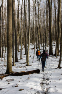 This Sunday, we will hike the Finger Lakes Trail (FLT) starting at the Mt. Morris Dam and Visitors Center Parking Lot. We expect to enjoy the height of winter as we follow the east rim of the Letch worth … Continue reading | ||||||
| Winter Hike, Ski or Snowshoe – All Western Evergreen Farm, Springwater 2:00 pm Winter Hike, Ski or Snowshoe – All Western Evergreen Farm, Springwater @ Liberty Pole Road Mar 9 @ 2:00 pm – 4:00 pm 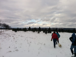 You are invited to hike, ski or snowshoe on a very special private property near the Northwestern corner of Springwater on the 248 acre All Western Evergreen Nursery & Christmas Tree Farm! Note, this hike was rescheduled from 2/16/25 date which … Continue reading | ||||||
| Hike at Sandy Bottom Park, Honeoye 2:00 pm Hike at Sandy Bottom Park, Honeoye Mar 16 @ 2:00 pm – 4:00 pm  Our hike this Sunday, March 16th will be at Sandy Bottom Nature Trail starting from Main Street across the street from Birdhouse Brewery (8716 Main Street Honeoye, NY 14471). This is where we will park and gather. The hike will … Continue reading | ||||||
| Canadice Westside Trail Hike 2:00 pm Canadice Westside Trail Hike Mar 23 @ 2:00 pm – 4:00 pm  This week’s hike will be on Canadice Lake Trail! This is an easy, 1.8-mile each way hike along the shore of the lake; the trail is level and well-maintained and the lake views are lovely. For most hikers it will … Continue reading | ||||||
| Hike at Affolter’s Farm, Hemlock 2:00 pm Hike at Affolter’s Farm, Hemlock Mar 30 @ 2:00 pm – 4:00 pm More details about this very special hike coming soon! Please check back. |
Our Sunday event will be a cross-country ski or snowshoe excursion on the groomed trails of the Finger Lakes State Park Region’s Harriet Hollister Spencer State Recreation Area. Because of the high elevation (over 2000 feet), the Park has been well used over the past few weeks of cold, snowy weather, and the groomers have kept the trails in great condition for both fast and slower skiers and for those on snowshoes.
Meet at 6775 Canadice Hill Road in the Town of Canadice, Ontario County. Park in the main lot near the road and gather near the kiosk at 1:45pm for a 2:00pm start. Rest rooms are available next to the lot. We will divide into groups depending on desired activity and distance.
- Cross Country Ski – A good easy run for skiers is the Overlook Road to the Raccoon Run trail and back.
- Snowshoe – A good route for those on snowshoes is an out and back on the Overlook and Bear Cub trails.
- Naturalist’s Hike – Hiking in the winter is limited because the trails are groomed for use by skiers and those on snowshoes. However, the Overlook Road is wide enough that hikers can go out and back (for a total of about 2 miles) without having to worry about colliding with skiers or post- holing the tracks. Poles and traction devices are recommended.
Trail Map
The trails are not well marked so it is recommended that you take a photo of the trail map at the kiosk or print a trail map using this link –https://parks.ny.gov/documents/parks/HarrietHollisterTrailMapWinter.pdf
Directions to Harriett Hollister Spencer State Recreation Area
From Springwater take East Avenue up the hill and then a left on Canadice Road (CR42). Make a right on Town Line Road (aka Tibbals). At the end, make a left on Canadice Hill Road. Go about 1.7 miles to the park entrance on your right.
From Honeoye/Hemlock take Route 20A east from Hemlock or west from Honeoye to the intersection with County Route 37. Go south approximately 3.7 miles to the point where County Route 37 curves to the right; go straight here on Canadice Hill Road. In about 3.2 miles the park entrance and parking area will be on your left.
Social
The social afterwards will be at Tee & Gee Bar and Grill, 6028 Big Tree Road, Lakeville, NY 14480 (585) 346-7387
Directions to Tee and Gee: From the park entrance go right on Canadice Hill Road for 3.2 miles to where it intersects County Route 37. Head straight (north) on County Route 37 for 3.7 miles. Turn left onto US-20A W / Honeoye Rd. (4 miles.) Turn right to stay on US-20A W / NY-15A / Main St (2.1 miles.) Keep left to stay on US-20A W / Richmond Mills Rd (proceed 4.5 miles.) You made it! Arrive at US-20A W / NY-15 / Big Tree Rd. The last intersection before Tee & Gee is Junior Crescent. If you reach Camp Run Dr, you’ve gone too far. Turn around and come back. Don’t worry, we’ll save you a seat!
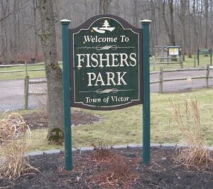
Join us on Sunday February 2nd for a hike around Fisher Park! Located in the hamlet of Fishers, this 93-acre park has a diversity of passive and active recreation opportunities. Visitors can see a multitude of wildlife from deer, squirrels, and other woodland creatures to waterfowl and trout that spawn in the spring. Trails meander through the park across wooded ridges, through wetland areas, and along the banks of Irondequoit Creek.
Everyone will meet at the parking area at 7938 Main St, Fishers (Victor), at 1:45pm for a 2:00pm start. Please dress appropriately for the weather.
The Hike:
Naturalists will explore mostly the outer perimeter on the White and Red trails. Included will be nice wide trails, a vista at a high point with a beautiful view looking out over the western side of the park, a stroll along Irondequoit Creek, and trail maps every so often showing your present location. Hikers will then loop back to the parking lot. The hike length is about 1.5miles with an option to add (we will vote on it) some small inner trails to extend hiking time.
Climbers/Tourists will also head out on the White trail but will cover more of the Yellow trails with rolling hills, ending on the Red trail along Irondequoit Creek and then loop back to the parking lot. Hike length is about 3 miles.
The Social:
The social afterwards is at the Cottage Hotel in Mendon (http://cottagehotelmendon.com) at the 4 corners in Mendon at 1390 Pittsford Mendon Road.
Directions:
Directions from Springwater and Honeoye: take County Road 37 north from Route 20A about 7 miles north to Route 5 and 20 in West Bloomfield. Route 65 begins there. About a half mile north Route 65 makes a sharp left turn. Do not go left, go straight onto County Road 35, otherwise known as West Bloomfield Road. Go about 6 miles up to Route 251 and turn right. You will come to the traffic light at the 4 corners of Mendon. Go straight ahead to Mile Square Road. There is no road sign at Mile Square Road so look for some bright lime green home made signs on either side of the road in about 1/2 mile. Turn left onto Mile Square Road. Main Street Fishers will be the third road on your right. After you pass Old Dutch Road on the right look for a green house at 7937 Main Street. The sign for the entrance to the Park is right after that house on the right.
Directions from Canandaigua and Farmington: Take Route 332 north to Route 96. Go north on Route 96 through the village of Victor all the way to a large intersection with a Valvoline, a Burger King, a car wash and a Chili’s Restaurant at the corners. Rowley Street goes to the right but turn left onto County Road 42. Go through the little hamlet of Fishers past the old Firehouse on the left and past Wangum Road on the left where the first entrance for Fishers Park is. You want the second entrance to the park farther down the road on the left.
Directions from Rochester: Take Route 490 East all the way to the Victor exit. It will take you right onto Route 96 South. At the first large intersection with Chili’s Restaurant on the right hand corner, turn right. Drive through the little hamlet of Fishers and after the old fire house on the left you will see a sign for the first entrance to Fishers Park on Wangum Road. Do not turn there. Go a little farther until you see the second entrance to the park on your left.
Directions to the Cottage Hotel:
Turn left (west) out of the parking lot of Fishers Park and go all the way to the end of Main Street. Turn left onto Mile Square Road. Turn right onto Route 251. Drive to the 4 corners of Mendon to the light. The Cottage Hotel is on the right.
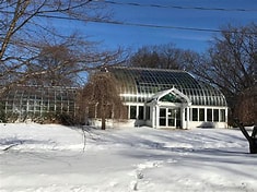
This Sunday, we will have the pleasure of hiking in Highland Park and or Visiting Lamberton Conservatory in the southeast part of Rochester!
George Ellwanger and Patrick Barry donated 20 acres of their nursery grounds, and, in 1888, Highland became the city’s first public park. Frederick Law Olmstead, who was the landscape architect for New York City’s Central Park, was engaged to be this park’s designer. Subsequent horticulturalists introduced rare and unusual plants from around the world to enrich the park’s botanical collections.
During the 20th century, Highland Park achieved international fame for its large assortment of lilacs and has the nation’s largest lilac collection. Many were developed in Rochester, and the annual Lilac Festival, held when they bloom in May, always draws a large attendance.
Hike Details: We will meet in the parking lot next to the Vietnam Veterans Memorial (1440 South Avenue Rochester, NY 14620), near the southwest corner of the park, at 1:45 PM, for photographs and orientation. Hike will start promptly at 2:00pm. Please dress appropriately for the weather.
We will then all walk north on the trail, cross Highland Ave., and continue until we come to a fork. From here, we will divide into 2 groups:
- One group will go right, remain outside and walk around the beautiful Reservoir, view magnificent sycamore trees and explore the surrounding areas and return to the lot afterwards.
- The other group will head left to visit the Lamberton Conservatory where they will remain inside and be treated to warm lush tropical and desert settings and view many great interesting displays of plants from many different kinds of habitats, that would not survive outside in the winter. The group will then leave the conservatory around 3:30pm and head back to the parking lot. *Please note there is a nominal admission charge of $3.00 (adult age 19-61) or $2.00 (age 62 and up.)
Social: After the hike, please join our optional social for refreshment and fellowship with your fellow hikers! We have a table reserved at the Elmwood Inn (1256 Mt. Hope Avenue, Rochester, NY 14620) http://elmwoodinn.net where we enjoyed good meals a short while ago.
Directions to the hike: From points around Springwater, go north on SR 15A. After crossing Westfall Road, fork right at the next light onto South Ave. After crossing Elmwood Avenue, look for the sign for the right turn into the Vietnam Veterans Memorial on Max Lill Drive. It is the second right after you pass the Al Sigl Center, immediately opposite Wall Street.
For those coming north on Interstate 390 continue on 390 (left) toward the airport at the split with 590. Take the first exit toward Route 15A (East Henrietta Road). Turn right at the exit, and go north past Westfall Road and fork right at the next light onto South Ave. After crossing Elmwood Avenue, look for the sign for the right turn into the Vietnam Veterans Memorial on Max Lill Drive. It is the second right after you pass the Al Sigl Center, immediately opposite Wall Street.
For those coming from the east or southeast, take Route 490 toward downtown Rochester. Take the Linden Avenue exit and turn left at the light. Linden will become Elmwood Avenue. In 4.4 miles, make a right on South Avenue, pass Al Sigl Center on the right, and then take the second driveway into the park, at the Vietnam Veterans Memorial sign (Max Lill Drive), immediately opposite Wall Street.
Directions to the social: The Elmwood Inn is at 1256 Mount Hope Avenue, at the corner of Mount Hope and Cook Street. From the hike parking lot, turn left on South Ave., then right on Cook Street (one way) just before the Elmwood Avenue intersection. The Elmwood Inn is on the corner of Mount Hope, left side. Or you can go right on Elmwood and enter the parking lot from behind Tim Horton’s.
With the Winter Weather Advisory continuing through the day Sunday, Katherine and her advisors have postponed the Christmas Tree hike. Please be safe and drive carefully if you need to be out tomorrow. We will see you next Sunday (check back here for details). And plan to join us at Katherine’s on March 9th.
You are invited to hike, ski or snowshoe on a very special private property near the Northwestern corner of Springwater on the 248 acre All Western Evergreen Nursery & Christmas Tree Farm!
The tree farm owned by Katherine Humphrey and daughter, Jerrianne Scheiderich was started in 1968, making 2024 the 56th year of planting trees. Participants may notice the many different species of Christmas trees planted and animal tracks to identify. Please stay on trails to avoid trampling seedlings that may not be seen under the snow. You will see hardwoods, a red pine forest (cathedral pines planted over 78 years ago), Christmas tree plantations (some trees up to 35 feet tall), a pond, wet areas and open fields and a gorgeous view from the hill tops toward East Springwater.
The entrance to the farm is at 6840 Liberty Pole Road (County Road 38, 1 mile from State Route 15 between Springwater and Webster’s Crossing). It is well marked and is on the high side of the road. There is parking to the left of the driveway opposite the Morton Building. Please follow the orange cones and park facing Liberty Pole Road.
The hike on Sunday, February 16th will begin at 2:00pm. Please plan to arrive by 1:45pm for hike instructions and group breakouts (i.e. Naturalists/Tourists and Climbers.) Dress for the conditions and feel free to bring poles, snowshoes and or skis.
Social: After the hike, plan to warm up and join the group onsite at Katherines house. Please bring a dish to pass or small monetary donation.
Directions: NOTE: If you are following your GPS to today’s hike, check that your directions actually go to Liberty Pole Road. If your route ends on Schwartz Rd, you will find you are a long way from the parking area you are looking for!
From Springwater: Go west from the Springwater light on Rt 15 North. Just past the top of the hill, turn left on Co Rd 38 (Liberty Pole Rd). The farm is on the left 1.1 miles from Rt 15 at 6840 Liberty Pole Rd.
From Geneseo: Go south on NY 63. About 6.4 miles after passing Rt 408, turn left on County Road 1 at Groveland. This road becomes CR 1A at Scottsburg (rt 256) and then Liberty Pole Rd (CR 38). It is 7.1 miles from Groveland to the All Western Evergreen Tree Farm.
From Honeoye: Take 20A west to Hemlock and 15A south to Springwater. Then follow the Springwater directions.
From Rochester: Take I390 south to Exit 9 (NY 15 / Lakeville). Turn left onto NY 15 and follow Rt 15 through Lakeville and Livonia (16.5 miles). Just past Webster’s Crossing stay straight on CR 60 when Rt 15 bears left. Take the first right off CR 60 onto Liberty Pole Rd (CR 38). The farm is on the left at 6840 Liberty Pole Rd.

The hike on Sunday, February 23rd will be at the Gosnell Big Woods Preserve which is a Town of Webster-owned nature preserve near Lake Ontario. Come explore a majestic old-growth forest, open fields, and meadows with a variety of trails! http://www.geneseelandtrust.org
Hikers will meet at 1:45pm for a 2:00pm hike start. Please park at the Gosnell Big Woods Preserve parking lot (674 Vosburg Road Webster, NY 14580). The car park is situated on the corner of Vosburg Road and Drumm Road. Dress appropriately for the weather. Snowshoes welcomed for both groups and skis for the Naturalists only.
Hike Details:
- Naturalists: will explore the Big Field and Meadow Trails, a total of 1.7 miles.
- Tourists/Climbers: will start in the Big Field and Meadow Trails and continue into Whiting Woods Preserve off Pellet Road for a total of about 4 miles.
Directions:
From Rochester and points south; Take Route 490 or 390 to Route 590 North. At 3.7 miles north of the 490/590 intersection, take Route 104 East across Irondequoit Bay, then north on Bay Road (1.1 miles), right on Klem Road (.8 miles), left on Drumm Road (.6 miles), and enter the car park where the road turns left at the junction of Drumm and Vosburg Roads.
Social: After the hike we will adjourn to a Donnelly’s Public House (1 Water Street Fairport, NY 14450) for food, drink and fellowship.
FLT
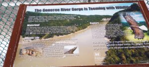

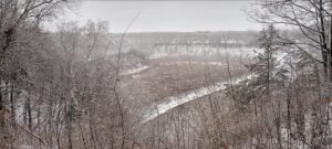
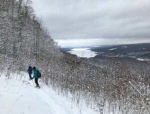
This Sunday, we will hike the Finger Lakes Trail (FLT) starting at the Mt. Morris Dam and Visitors Center Parking Lot. We expect to enjoy the height of winter as we follow the east rim of the Letch worth Gorge, the spectacular views of the gorge and Genesee River. Poles and traction devices are recommended.
Three levels of hiking are planned – “Climbers”, “Tourist, and Naturalists”.
The Tourists will hike south on the yellow blazed (FLT) trail along the rim of the gorge, stop at Hogsback Overlook to view the Hogsback formation of the river gorge, continue on the trail and after hiking 1 hour, turning around to head back. On the way back, we will follow the same yellow blazes but take the alternate orange blazed trail along the rim of the gorge which joins back up with the yellow trail, back to the parking lot. Total hike is 3.25 miles.
The Naturalists will follow along the same route as the Tourists but at a leisurely pace and turn around after 1 hour.
Depending on trail conditions, the Climbers who want a longer hike can hike from the Visitors Center following the yellow blaze Finger Lakes trail down to Lorenz Park in the village and return back on the Finger Lakes Trail. Climbers can continue along the Finger Lakes Trail south following the yellow blaze markers along gorge trail to complete the 2 hour hike.
The Hike Assembly Point:
Try to arrive about 1:45pm
The Visitors Center will be closed so the bathrooms will also be closed however, there is a primitive bathroom adjacent to the parking lot that remains open through the winter. All hikers will begin the hike at the Mt. Morris Dam Visitor Center Parking Lot. The trail access is at the west end of the parking lot (to your left as you face the gorge).
Social:
After the hike, all are welcome to gather at a local eatery in Mt. Morris. High Banks Tavern located on the northwest end of Main St., is a option.
Directions:
The Mt Morris Dam Visitor Center is about 45 minutes from Springwater, so please plan ahead. If you have a GPS, try entering Mt Morris Dam as your destination. Or enter Damsite Rd or 6103 Visitor Center Rd, Mt Morris.
From Springwater: Take Rt 15N and then left on Liberty Pole Rd. Stay on that road all the way to Rt63. There, take a left, and a quick right, onto Rt 258. At Rt 36, take a right and proceed to Mt. Morris. Turn left onto NY-408 South.
From Wayland: you can take I-390 north to exit 7. Turn left at the exit on NY-408 S to Mt. Morris. NY-408 goes left at Main St, then right on Chapel St.
From Hemlock and Honeoye: follow 20A West through Livonia and Lakeville to 390S. Exit at exit 7 NY 408 S to Mt Morris. Stay on 408 through Mt Morris.
From Rochester: Take I-390S to Exit 7 NY 408S. Stay on Rt 408 through Mt Morris.
From NY 408 in Mt Morris: Go south on 408 for 1.8 miles to Visitor Center Rd. Turn right at the Visitor Center Road and follow the road all the way to the Dam and Visitor Center Parking.
You are invited to hike, ski or snowshoe on a very special private property near the Northwestern corner of Springwater on the 248 acre All Western Evergreen Nursery & Christmas Tree Farm! Note, this hike was rescheduled from 2/16/25 date which was cancelled due to weather conditions.
The tree farm owned by Katherine Humphrey and daughter, Jerrianne Scheiderich was started in 1968, making 2024 the 56th year of planting trees. Participants may notice the many different species of Christmas trees planted and animal tracks to identify. Please stay on trails to avoid trampling seedlings that may not be seen under the snow. You will see hardwoods, a red pine forest (cathedral pines planted over 78 years ago), Christmas tree plantations (some trees up to 35 feet tall), a pond, wet areas and open fields and a gorgeous view from the hill tops toward East Springwater.
The entrance to the farm is at 6840 Liberty Pole Road (County Road 38, 1 mile from State Route 15 between Springwater and Webster’s Crossing). It is well marked and is on the high side of the road. There is parking to the left of the driveway opposite the Morton Building. Please follow the orange cones and park facing Liberty Pole Road.
The hike on Sunday, March 9thth will begin at 2:00pm. Please plan to arrive by 1:45pm for hike instructions and group breakouts (i.e. Naturalists/Tourists and Climbers.) Dress for the conditions and feel free to bring poles, snowshoes and or skis.
Social: After the hike, plan to warm up and join the group onsite at Katherines house. Please bring a dish to pass or small monetary donation.
Directions: NOTE: If you are following your GPS to today’s hike, check that your directions actually go to Liberty Pole Road. If your route ends on Schwartz Rd, you will find you are a long way from the parking area you are looking for!
From Springwater: Go west from the Springwater light on Rt 15 North. Just past the top of the hill, turn left on Co Rd 38 (Liberty Pole Rd). The farm is on the left 1.1 miles from Rt 15 at 6840 Liberty Pole Rd.
From Geneseo: Go south on NY 63. About 6.4 miles after passing Rt 408, turn left on County Road 1 at Groveland. This road becomes CR 1A at Scottsburg (rt 256) and then Liberty Pole Rd (CR 38). It is 7.1 miles from Groveland to the All Western Evergreen Tree Farm.
From Honeoye: Take 20A west to Hemlock and 15A south to Springwater. Then follow the Springwater directions.
From Rochester: Take I390 south to Exit 9 (NY 15 / Lakeville). Turn left onto NY 15 and follow Rt 15 through Lakeville and Livonia (16.5 miles). Just past Webster’s Crossing stay straight on CR 60 when Rt 15 bears left. Take the first right off CR 60 onto Liberty Pole Rd (CR 38). The farm is on the left at 6840 Liberty Pole Rd.
Our hike this Sunday, March 16th will be at Sandy Bottom Nature Trail starting from Main Street across the street from Birdhouse Brewery (8716 Main Street Honeoye, NY 14471). This is where we will park and gather.
The hike will begin at 2:00pm. Please plan to arrive by 1:45pm for hike instruction and participation in our beloved group photo.
The hike will begin by exploring the beach then progress to the loop nature trail where hikers will be treated to early spring sights and sounds of the surrounding woods and open field and then return to Main Street. Our hike (about 2.5 miles) will be a combination of field and woods on a relatively flat terrain.
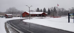
Social: Please join us afterwards at the BirdHouse Brewing Company at 8713 Main Street, Honeoye, for restorative food and beverages and some entertainment. http://birdhousebrewing.beer
This week’s hike will be on Canadice Lake Trail!
This is an easy, 1.8-mile each way hike along the shore of the lake; the trail is level and well-maintained and the lake views are lovely. For most hikers it will be a walk along the lake for an hour or so and then back the same way; more enthusiastic hikers can veer off on Rob’s Trail that leads over the ridge and down to Hemlock Lake – this is a moderate to hard trail with several steep uphill and downhill section. Dress appropriately for the weather, carry water and some energy food, and carry a walking pole if it helps. Leashed pets are welcome.
The Meet-Up Location
All hikers will meet at 1:45pm in the parking area off Purcell Hill Road, Town of Canadice, Ontario County. Google Maps (leaves this website) Click here for directions. Please plan to arrive early enough to park and get dressed for the weather conditions.
The Social: The after-hike social will be at the Bird House Tavern off Main Street in Honeoye NY.
More details about this very special hike coming soon! Please check back.
Looking for brochure.or mailing list so I can receive it in the mail.
Nothing opens up for mailing list.
There’s all kinds of very bizarre ads and post for viagra and other drugs above on calender page.
Please let me know if there’s a brochure available