Hikes led by Springwater Trails are generally held on Sunday afternoons and appear in this calendar in green.
- Categories
- Tags Barry Childs and Kathy Cloonan barry@africabridge Bike Bill Cooke Bob and Cindy Wagner Bob Menz (bert6952@yahoo.com) Bristol Hills Branch CANCELED Clarks Gully CLWA Colorado Trail Dena Munsell Dog friendly Finger Lakes Trail FL FLT Gene & Georgia Binder (585) 236-5384 Gene and Georgia Binder (585) 236-5384 Greenway Gully Gypsy moth Hemlock Hike Jayne Affolter Jeanie Smith John L Katherine Humphrey? Kayak Kelly Rell Landowner Liability Leader: Mark Lehigh Valley Trail Mark and Laure Allen (585) 662-9305 Mark and Linda Mary Ann Devey (315) 573-0774 Mary Lou Wenthe (585) 208-4337 Melissa Mike and Jenny Johnson Mitchellsville mjkcloonan@frontiernet.net Mushroom Foray Naples Nunda POSTPONED Rick Henchen Rick Henchen and Sharon Boldt Saralinda Saralinda Hooker Schribner Sharon Boldt Sharon Boldt (boldtbs@yahoo.com) sugarbush hollow Summer Weekly Wendy Stevenson
| Sun | Mon | Tue | Wed | Thu | Fri | Sat |
|---|---|---|---|---|---|---|
| Lehigh Valley Trail Hike or Bike in Rush, NY 2:00 pm Lehigh Valley Trail Hike or Bike in Rush, NY @ Stevens-Connor Lehigh Valley Lodge Apr 6 @ 2:00 pm – 4:00 pm Come join us for a leisurely hike or bike along the Lehigh Valley Trail on Sunday April 6th! With its flat even surface, the trail is a hidden gem for walking, hiking, jogging, biking. It is a vital link in … Continue reading → | ||||||
| Ontario County Park at Gannett Hill Hike-Naples 2:00 pm Ontario County Park at Gannett Hill Hike-Naples Apr 13 @ 2:00 pm – 4:00 pm 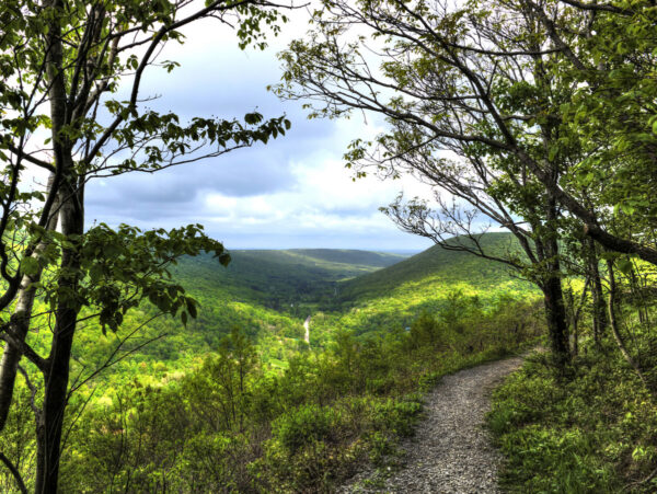 Save the date! This is one of our group favorite hikes. Ontario County Park at Gannett Hill is one of the highest points in Ontario County and located in the scenic Bristol Hills. At an elevation of 2,256 feet above … Continue reading → | ||||||
| No Hike-Easter Break 2:00 pm No Hike-Easter Break Apr 20 @ 2:00 pm – 4:00 pm No hike has been scheduled for this date due to the Easter Holiday. Enjoy the break, spend time with loved ones and eat chocolate bunnies. This will give you something to burn off next week  | ||||||
| Mystery Hike- Richmond/Honeoye 2:00 pm Mystery Hike- Richmond/Honeoye Apr 27 @ 2:00 pm – 4:00 pm Mystery hike coming your way! Please check back for more details. |
-
Categories
-
Tags
Barry Childs and Kathy Cloonan barry@africabridge Bike Bill Cooke Bob and Cindy Wagner Bob Menz (bert6952@yahoo.com) Bristol Hills Branch CANCELED Clarks Gully CLWA Colorado Trail Dena Munsell Dog friendly Finger Lakes Trail FL FLT Gene & Georgia Binder (585) 236-5384 Gene and Georgia Binder (585) 236-5384 Greenway Gully Gypsy moth Hemlock Hike Jayne Affolter Jeanie Smith John L Katherine Humphrey? Kayak Kelly Rell Landowner Liability Leader: Mark Lehigh Valley Trail Mark and Laure Allen (585) 662-9305 Mark and Linda Mary Ann Devey (315) 573-0774 Mary Lou Wenthe (585) 208-4337 Melissa Mike and Jenny Johnson Mitchellsville mjkcloonan@frontiernet.net Mushroom Foray Naples Nunda POSTPONED Rick Henchen Rick Henchen and Sharon Boldt Saralinda Saralinda Hooker Schribner Sharon Boldt Sharon Boldt (boldtbs@yahoo.com) sugarbush hollow Summer Weekly Wendy Stevenson
Join us on Sunday the 29th to celebrate the season in your hiking boots or on your skis as Mondoe County sponsors the 2023 Winterfest at Mendon Ponds Park. Everyone, both hikers and skiers, will meet at the Nature Center parking area at 27 Pond Road, Mendon at 1:45 for a 2PM start. Naturalists and Tourists will explore the Birdsong and Swamp Trails adjacent to the Nature Center on foot, while Climbers will hike north and east to hike the Grassland and Devil’s Bathtub trails, crossing over to the East Esker and Quaker Pond Trails to make a loop of about 5.5 miles. This is a fairly level hike, but we advise poles and traction footwear in case of ice, mud or slush.
Ski conditions are expected to be marginal, as there were only a few inches of wet snow on the ground as of Friday, and some light rain is possible Sunday. The trails will probably be busy on Sunday due to Winterfest activity, so any groomed tracks may be trodden over or melted down. Bring your ski equipment if you want to give it a try, but we suggest you bring hiking boots and equipment also as a backup plan.
Come early for more family-oriented activities elsewhere in the park between 11 and 3. See https://www.monroecounty.gov/parks-winterfest for a line-up, including food trucks at Stewart Lodge, sledding, equipment and winter sports demonstrations, Wild Wings, Zoomobile, Mercy Flight, Mounted Patrol, and more. Mendon Ponds Park map
Social afterwards at Flaherty’s Restaurant, 60 W. Main Street, Honeoye Falls.
Directions to Nature Center:
From Springwater: Head north on 15A for 21.6 miles through Hemlock and Lima. Take a right at the exit to Honeoye Falls. Stay on W Main St into the village where you will join NY 65 (1.9 mi). Continue straight onto NY 65 for 4.4 mi. (At 2 miles, you will go around a traffic circle. Stay on NY 65.) Turn right onto Pond Rd at the first park entrance. The Nature Center is just inside the entrance, on the right.
From Honeoye, take US 20A west and head north on CR 37 for 8.2 miles to W Bloomfield. Continue straight on NY 65 for about 3 miles, and make a right on Quaker Meeting House Road just before you come into Honeoye Falls. When Quaker Meeting House Road ends at Route 251 (Rush-Mendon Road), go left and then right on Route 65/Clover Street. The Pond Road entrance to the park is about 2 miles to the north, on the right. The Nature Center is just inside the entrance, on the right.
From Rochester: Exit I590 at Monroe Ave toward Pittsford. Turn right (south) onto NY 65 (Clover St). In about 6.7 you will come to the Canfield Road entrance to the park – this is not the one you want. Continue another 1.5 miles, then turn left onto Pond Rd, the second entrance into the park. The Nature Center is just inside the entrance, on the right.
Directions to Flaherty’s for Social: From Nature Center parking lot, go left to Clover Street (Route 65) and then left toward Honeoye Falls. Proceed about 5.5 miles to Honeoye Falls and through the center of the village. Flaherty’s will be on your left at #60 W. Main Street, which is Route 65.
This is a great trail to X-country ski, but it looks like we will just be just hiking this Sunday. It’s all flat and scenic and usually groomed if there is a good snow base. There is presently only an inch or two of snow, so not good skiing this time.
This week our Sunday hike will be an easy out and back, hiking with an after social at the Cottage Hotel in Mendon, New York. The Mendon trail begins where we park at the Little League ball field just off Route 251 west of the four corners of Mendon, 3865 Rush-Mendon Road. We’ll be hiking west from Mendon out about an hour with a turn-around at Chamberlain Road. It’s all flat about 4 miles out and back. Those that wish more distance, if time, can explore the trail east from Mendon toward Fishers.
This linear park has an interesting history. It’s a 15 mile plus trail extending from Ontario County through Mendon and Rush to the Genesee River with a north extension into Henrietta. It was purchased in 1995 for $1,300,000.00 and was completed and transitioned in 2004 from the old Lehigh Valley railway to a recreational trail for biking, running, cross country skiing, hiking and horseback riding.
After the hike about 4 pm, we’ll be walking from the ball park parking lot to the four corners of Mendon to the Cottage Hotel on the north east corner.
Directions: From West Bloomfield at the traffic light head north on Route 65 and in .7 miles, don’t take the curve, go straight and you will be on County Road 35 (West Bloomfield Road). Travel straight for 5.9 miles, when you reach the stop sign at Route 251, turn right. In about a mile, right across from the Ye Mendon Tavern on your left, turn right into the parking lot at the Little League Ball Field. Plenty of parking there.
Springwater Trails’Winter Hike on Sunday, February 12, 2023 on the All Western Evergreen Nursery & Christmas Tree Farm (www.allwesterntrees.com) in beautiful Springwater will begin at 2 PM, for best experience come early around 1:45 PM to sign in and meet the leader for each group.

The Western Evergreen Tree Farm in Springwater, NY
You are invited to hike on private land near the Northwestern corner of Springwater on the 245 acre All Western Evergreen Nursery & Christmas Tree Farm owned by Katherine Humphrey and daughter, Jerrianne Scheiderich. The entrance to the farm is at 6840 Liberty Pole Road (County Road 38, 1 mile from State Route 15 between Springwater and Webster’s Crossing). It is well marked and is on the high side of the road. There is parking to the left of the driveway opposite the Morton Building. Please follow the orange cones and park facing Liberty Pole Road, and sign in. Depending on the number attending, participants will be divided into Climbers (4 mile, fast pace), Tourists (3½ – 4 mile, moderate pace), and Naturalists (2-3 mile, slow pace). Designated volunteer leaders will be leading each of the hikes. Farm maps will be available so as to stay on the Farm. Please do not wander onto the neighbor’s lands. Please follow your snowshoe, ski, or hike leader (subject to the vagaries of the weather). Select a person to be the sweep (last person to keep a count of who is hiking in the group) so as not to have anyone wander off or get lost along the way.
On the hike, expect winter conditions. If there is enough snow, skis and snow shoes can be used. Dress warmly and bring water, poles, and snacks, as desired. Masks and social distancing are okay, if desired, along with all the usual precautions we’ve become accustomed to. Most of us have had the recommended vaccines and booster shots. Beware of stones, drifts, woodchuck holes, brush and stumps. We will all meet at the farm parking lot behind the house at 6840 Liberty Pole Road, Springwater, NY 14560 (GPS might say Dansville, NY 14437). Please be sure to take the Liberty Pole Road entrance at the start.
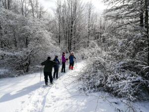
The Western Evergreen Tree Farm in Springwater, NY
Depending on weather conditions, those who want to ski will drive up to the entrance to the farm off Swartz Road following the ski leader. The Skiers will crisscross the farm from the entrance on Swartz Road, across the tree plantations, through the woods, across the tillable strips to the largest trees on the farm in the Scott Hill triangle and return. Those who wish are invited to come back to the parking lot behind the house to attend the dish-to-pass social.
It is about 1 mile across the farm in either direction; about 4 miles around the perimeter. The Tourist leader will select a route around the perimeter to see the largest trees on the farm, including Concolor fir and Red Pine. Katherine will lead the slow-paced group. Both of these groups will start out from the parking lot behind the house. The nursery beds and several exotic trees are near the residence. There is a leisurely incline from 1200 to about 2000 feet to the top of the farm and back.
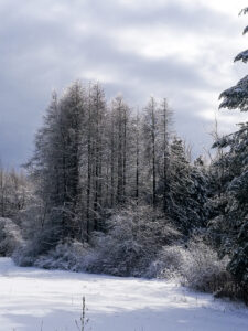
The Western Evergreen Tree Farm in Springwater, NY
The tree farm was started in 1968, making 2023 the 55th year of planting trees. Participants may like to notice the many different species of Christmas trees planted and the animal tracks to ID. Please stay on trails to avoid trampling seedlings that may not be seen under the snow. You will see hardwoods, a red pine forest (cathedral pines planted over 75 years ago), Christmas tree plantations (some Concolor fir trees up to 35 feet tall planted in the early 1980’s), a pond, wet areas and open fields and a gorgeous view of East Springwater from the hill tops.
After the hike, a choice of hot, home-made soups will be at the farm house and people can bring their dish-to-pass before or after the hike (refrigeration, range and sockets are available). Depending on the size and comfort of the group, the garage area can be our shelter with the option of having the doors open. You are invited to bring a dish to pass, a folding chair, your preferred drink and stay for the social at the house between 4:00 and 6:30 PM.
Directions to the Farm:
From the South or North if you come down State Route15A, Springwater hamlet, at the blinking light intersection of State Route 15A, drive north on State Route 15 for a couple of miles and take the second left onto County Road 38 (Liberty Pole Road). Cross the first intersection (Carney Hollow Road, County Road 60) and in a tenth of a mile on the left high side of the Liberty Pole Road across from the 45 mile an hour sign, you will see the Tree Farm sign at 6840 Liberty Pole Road). Turn left and follow the orange cones up to the parking area and park facing forward toward Liberty Pole Road for ease in leaving at the end of the day.
From Conesus or the North, on State Route 15, go south through Webster Crossing and go straight up the Carney Hollow Road (County Road 60). At the first intersection, turn right onto County Road 38 (Liberty Pole Road) and go a tenth of a mile. Near the 45 mile an hour sign you will see the Tree Farm entrance at 6840 Liberty Pole Road. Turn left onto the high side of the road, follow the orange cones and park facing forward toward Liberty Pole Road for ease in leaving at the end of the day.
From the West from Groveland Station, take County Road 1 to Scottsburg, straight onto County Road 1A to Stage Coach Road. Go straight onto County Road 38 to 6840, where you will see the Tree Farm sign on the high side. Turn right and follow the orange cones and park facing forward toward Liberty Pole Road for ease in leaving at the end of the day
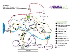
Please join us for a hike at Cumming Nature Center, in the hills above Naples. Conditions are currently poor for skiing or snowshoeing but walking should be no problem. Cumming is a branch of Rochester Museum and Science Center; if you are not a member of RMSC, there is a $5 access fee to the Center; this provides access to their rest rooms, birding platforms, snacks (free popcorn) and impressive exhibits on local wildlife.
We will meet at 1:50 inside the Visitors’ Center and split into groups to make best use of the available trails and the ambitions of our hikers; trails of various lengths extend north and south from the Visitors’ Center. We will break up into two activity groups: the hikers will take one or more hiking trails. If there is enough snow then the cross country skiers and snowshoers will take the purple ski trails.
The Social: We’ll have a pot luck supper in the fireplace room. The Center closes at 5 PM.
Cumming-SummerTrailMapforPrinting_1_1
Directions
From Rochester and points North: Take 390 South to Routes 5 & 20, Proceed to Rt15A in Lima. Head South on Rt15A to Route 20A in Hemlock, Head East on 20A to East Lake Road in Honeoye. Proceed South on East Lake Road a short distance to County Road 33, (there are signs pointing the way from the junction of East Lake Road and County Road 33). Turn East on County Road 33, then Southeast on Pinewood Hill Road, which becomes becomes Gulick Road. After 5.6 miles the CNC entrance will be on the right.
From Springwater: Go North on Rt 15A to Route 20A in Hemlock, Head East on Rt 20A to East Lake Road in Honeoye. Proceed South on East Lake Road to County Road 33 (Signs point the way from the junction of East Lake Road and County Road 33). Turn East on County Road 33, then Southeast on Pinewood Hill Road. This becomes Gulick Road. After 5.6 miles the CNC entrance will be on the Right, about 1.5 miles past the Wesley Hill parking lot. OR, go to Naples and follow the directions below. They are both about 23 mile routes.
From Wayland, Naples, and points South: Follow NY 21 East from Wayland, through North Cohocton to Naples (11.4miles). Turn Left onto Clark Street (County Rd. 36), heading North (Next to Middletown Tavern). Take first Right onto Gulick Road. Follow Gulick Road for 6.6 miles. CNC will be on the Left.
NOTICE: Saturday afternoon there was about 2 inches of snow on the ground. Skiers were able to go around the park without trouble. However, the temperature is predicted to be 40 tomorrow, so it is likely that the snow will be noticeably wetter. Skiers are welcome to bring their equipment. I will provide maps and recommendations, and skiers can select their own leader. Bring hiking boots in case ski conditions have gotten worse.
NOTICE: Also on Saturday, there was ice under the snow, which made the hills a bit tricky. Traction devices (spikes or good hiking treads) and poles are recommended.
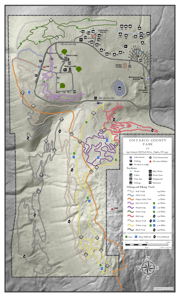
Ontario County Park provides hiking, biking, cross country skiing, fishing (no hunting), and camping or picnicking opportunities depending on the season. The park contains the highest point in Ontario County, and as a result it often has long lasting snow cover.
Please join us at the west parking along the main park road near the start of the Bristol Branch of the Finger Lakes Trail. Come early enough to get your equipment ready. We will start the hike at 2:00PM.
There are many trails within the park, although the bike trails are difficult to follow in the winter. The following planned hikes may change based on the weather and the snow cover on Sunday.
The Climbers will follow the Bristol Hills Branch of the FLT out to the overlook and then around to the south to the FLT sign-in box. At that point, we will turn around, and follow the yellow trail back to the park road and then the brown trail back to the cars. If time permits, we will explore the purple trail across the road rather then the brown trail. Poles will be helpful at slippery locations.
The Naturalists will also follow the Bristol Hills Branch out to the overlook. From there, we will leave the orange trail, turning right and follow the edge of the hill around to the north edge of the park and walk on the green trail to the campgrounds. Heading south on one of the campground roads will bring us to the park road and the field beyond. The field is open and we will head to the purple trail and back to our cars.
Social: Following our hike, join us at Brew & Brats for refreshments and conversation. Continue straight down Gannett Hill Rd to the bottom. Turn right on NY-64. Brew and Brats is on the left.
Directions: The easiest route to the park is to take NY 64 to Bristol Springs and turn west on Gannett Hill Rd. There is a sign indicating Ontario County Park. At the top of the hill turn right onto South Gannett Hill Road. The park entrance is straight ahead. Follow the park road for about .5 miles to our meeting place which is the parking area along the park road near the information kiosk at the Finger Lakes Trail trail-head.
Details From Springwater, Wayland and Naples: From Springwater, head south on NY-15. At the light in Wayland, turn left and follow NY-21 through Naples. Just past the village, bear left onto CR-12 (Bristol Springs Rd). In 1.9 miles, bear left onto Rhine St. Continue straight (In .6 mi, the name changes to Powell Rd and then in .3 mi to Gannett Hill Rd, and then in 3.2 miles it enters the park). Follow the road around the park for half a mile to our meeting place.
Details from Hemlock and Honeoye: From Hemlock, head south on NY-15A. Just outside of the hamlet, turn left on US-20A. Continue through Honeoye and turn right onto East Lake Road. In 0.6 mi, turn left onto CR 33 (Egypt Valley Rd.). In 6.9 miles, continue straight onto CR 34. In 1.6 miles, turn right onto NY-64. In another 1.9 miles, turn right onto Gannett Hill Rd. In 1.3 miles, turn right into the park. Follow the road around the park for half a mile to our meeting place.
Details from Canandaigua: Take US 20 west out of the city. Turn left onto Parrish St Ex. In 0.9 miles, turn left onto NY-21. Continue for 11.9 miles to the intersection with NY-64. Turn right onto NY-64 N. In 0.4 miles turn left onto Gannett Hill Rd. In 1.3 miles, turn right into the park. Follow the road around the park for half a mile to our meeting place.
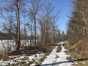 This Sunday we will enjoy a leisurely stroll along the Hemlock Lake shore on the northwest section of Rob’s Trail. The Climbers will continue up Rob’s Trail to Route 15A, and from there they’ll be ferried back to the hike start point; Naturalists and Tourists will stay on the lake shore trail and turn back to the start point whenever it suits them. The mild winter will continue this week so we’re not expecting much snow cover. If the lake level is low we can walk on the beach, but the trail offers a good flat and mostly well-drained surface. Here and there we will encounter a minor stream to cross by either wading or jumping, so waterproof footwear and poles are advised. Just in case of lingering ice or slippery mud, spikes or Yaktrax are a good idea too.
Meet at the north boat launch, at the end of the old east lake road, a sharp left after you first enter Rix Hill Road from Route 15A. This will be an out and back hike for Naturalists and Tourists; may return at any point; while Climbers will walk all the way to Route 15A for a shuttle back to the start point. At about 1.75 miles we will encounter a more substantial stream across the trail, probably too large to leap over. Any Climber wishing to proceed on Rob’s Trail past this point is advised to bring wading boots. Turning around at this point will give you a hike of 3.5 miles and a little under 2 hours.
Optional Social: Please join us at the Birdhouse Brewing Company in Honeoye – 8716 Main Street, just east of the traffic light, for craft beer and pub food.
Directions: From Springwater: proceed north on Route 15A 19 miles, then make a left on Rix Hill Road and an immediate left on Old East Lake Road, aka Boat Launch Road.
From Honeoye and points east: Take Route 20A west from the Bristol Valley and Honeoye. When 20A meets Route 15A, make a left and go about .6 miles to Rix Hill Road. Make a right and then an immediate left on the dead end road to the boat launch parking area in one mile.
From Rochester and points west: Take Route 15 south from Henrietta or Route 15A south from Honeoye Falls, or Route 390 south to the Lakeville-Livonia exit, then go south on Route 15 and then east on Route 20A through Hemlock. When Route 20A turns east toward Honeoye, go straight another .6 miles and make a right on Rix Hill Road. Then make an immediate left onto the boat launch road and go to the end, 1 mile.
To the Social: From the Boat Launch parking area, return to Rix Hill Road, make a right and then a left on Route 15A. Go .6 miles and make a right on Route 20A. In about 4.75 miles you will reach the traffic light in Honeoye. A few buildings beyond the light is Birdhouse Brewing on the left at #8716.
Please join us this Sunday for a cross country ski, , snowshoe or hike, while exploring a hiking site not far from Springwater. A few years ago New York State acquired several new parcels of land to the south of Harriet Hollister Spencer Park, linked to the main park by an established snowmobile trail called C4.In the past, we’ve hiked the section of the C4 trail closest to the main park, and this Sunday we will snowshoe and hike from the parking lot, following Ruthies trail, to Chalet trail to C4 trail. We will follow C4 to a point where we will turn onto a old single track hiking trail(red dashed) that crosses the “Sidewinder” trail through the south east section of the park. we’ll follow this around and return back to the parking lot via the single track trail (red dash trail) which runs parallel with the overlook road.
Skiers will start out at the parking lot and may choose to take any of the many trails in the park or venture out of the main park on C4. This is a challenging ski as there are a few uphill climbs but finishing with a nice view out in a wide open field. Skiers can return to the main parking area by returning back on C4.
Wear proper clothing according to prevailing weather conditions . As always, bring water, skies and poles good hiking footwear, snowshoes and poles if you typically use them. The trail is gently rolling – no especially steep sections. Weather conditions at this time look favorable for cross country skiing.
Optional Social: Please join us at the Birdhouse Brewing Company in Honeoye – 8716 Main Street, just east of the traffic light, for craft beer and pub food
Directions:
From Springwater and Wayland – take Route 15A North from Springwater, turning right on Wheaton Hill Road. Take a left on Canadice Road (County Road 42), forking to the right when County Road 42 divides off from Canadice Lake Road. Make the next right, on Tibbals Road (formerly Town Line Road). In 1.0 miles, Take the first left onto Ross Rd. At the stop sign (2.7 miles), take a sharp right onto Canadice Hill Rd. The parking lot will be on the left in 0.8 miles..
From Rochester or Canandaigua – go to Honeoye, and follow Route 21A (Main St. Honeoye) west toward Hemlock. About a mile out of Honeoye turn left on County Road 37. Follow County Road 37 until it makes a 90 degrees turn to the right across from the Canadice Methodist Church; at this point go straight onto Canadice Hill Road instead of County Road 37. Continue straight on Canadice Hill Road, taking the left fork at Ross Road, The parking lot will be on the left in 0.8 miles..
Our Spring Equinox hike this year will be in Ellison Park in the City of Rochester.  This city park dates back to 1926, and covers 447 acres of city land. It has woodlands, steep slopes and the level flood plain of the Irondequoit Creek. There is one designated sledding hill and a non-motorized/car-top boat launch allowing boat access to Irondequoit Creek.
 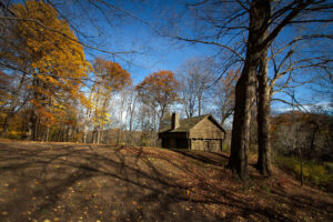 This plot of land encompasses much of the history of the locale before the city was built here. Fort Schuyler is a replica of the original Fort; Indian Landing was located on Irondequoit Creek and was used by the indigenous Iroquois as the beginning of the portage route which stretched along Ellison Park. The Lost City of Tryon, originally founded in hopes of creating a commercial settlement, used the Irondequoit Creek for trade. A store was built that bartered with the Seneca Indians, beginning Rochester’s trading roots.
You can print a copy of the park trail map here: EllisonParkMap (monroecounty.gov) The GPS coordinates of the lodge are 43.15107, -77.5133.
The Hike Meeting Place
From all points south:
1: Find you way onto the I-490 going north (that’s west in highway terms) towards Rochester
2: Use the right lane to take exit 21 for NY-590 N. Keep right at the fork, follow signs for State Route 590 N and merge onto NY-590 N
3: Take exit 6 for Blossom Rd. Turn right onto Blossom Rd
4: Ellison Park is bisected by Blossom Road; turn north onto Ellison Park Road and follow signs to Hazelwood Grove Lodge car park. Note; do not park in the dog park immediately off Blossom Road.
The Hikes
-Naturalists and Tourists will hike from Hazelwood Grove to The Pavilion round the hill, crossing Irondequoit Creek at the Indian Landing site. Visit the Fort Shuyler Trading Post and return via the service road along the creek to Hazelwood Grove.
-Climbers will cross Blossom Road then onto Rich’s Dugway Road to Coyote Trail. From Coyote trail we will take the Overlook Trail to the Overlook. On the return there will be the option of going up a beautiful gorge up to Penfield Road. From there we will return to Hazelwood Grove via the Coyote Trail.
Note; there is a very steep climb, half a mile into the hike. Poles are recommended. If it is icy, it would be good to have some extra traction on your boots.
The Social
Drive to Tryon City Tavern, 2300 Main Street, Rochester, for restorative sustenance and libations. The GPS coordinates of the tavern are (43.15946, -77.54940).
This is a change from the earlier published schedule. The Letchworth Park hike will be rescheduled for a Sunday later in the spring.
On Sunday the 26th, we will hike or bike on the Genesee Valley Greenway from Route 20 (a.k.a Telephone Road) north to the Erie-Attica Trail and beyond. The Greenway is a level and easy hike, about as well-drained a path as we will find at this time of year, and a new hike for some of us. The Greenway is a public multi-use trail following the route of the 19th century Genesee Valley Canal and the subsequent Pennsylvania Railroad’s Rochester Branch. It currently extends from Rochester to Cuba, NY, with plans for further extension to the south. It generally parallels the Genesee River on the west side. The Erie-Attica is a more recent rail trail including a trestle bridge across the Genesee.
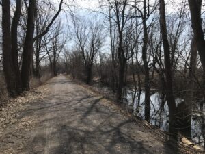
Our meeting place is where the Greenway crosses Route 20, which splits away from Route 5 just west of the Village of Avon. There are Pedestrian Trail crossing signs, and ample parking is available on the north side of the road. All participants will head north, crossing Route 5 and going on to the intersection with the Erie-Attica Trail at 1 mile. Naturalists or anyone desiring a 2-mile hike can return to the start from this point. Tourists or those inclined to a medium length hike can head east on the Erie-Attica Trail for one mile to the Genesee River crossing on the old railroad bridge, then return to the start for a total of 4 miles. Climbers may choose to take in the Erie-Attic and then continue north on the Greenway as far as you choose before returning to the start. Any Cyclists may wish to ride north as far as the bridge and intersection of the Greenway with the Lehigh Valley Trail at 5.6 miles (13.2 miles with return) or all the way to Canawaugus Park in Scottsville and back for a 16.5 mile ride.
Showers are expected on and off for the later part of the week, but the trail is flat and firm, with a new layer of stone dust through most of it. The first mile has a grass and dirt surface.
Social – We will repair for restorative food and beverages at the 3-Legged Pig, 3415 Rochester Road, Lakeville, just north of the main intersection. See food menu at https://www.3leggedpig.com/menu. Beer is also available.
Directions – From Springwater and points south, take Route 15 north through Livonia and Lakeville to Route 5&20. Go west 3 miles on 5&20 through Avon to the point where Route 20 splits off to the left. Take Route 20 another mile to the Greenway crossing and start of hike. Parking on the north.
From points north and east, take Routes 5&20 heading west to Avon and beyond, forking left where Route 20 splits off from Route 5. In another mile you will come to the trailhead. Parking on the north. If you are coming on Route 390 from Monroe County, get off at Exit 10 and go west toward Avon, then left at the Route 20 split.
To the Social – Head back east on Route 20 and then Route 5&20 through Avon. Take Route 15 south to Lakeville. the 3Legged Pig will be on your left just before the main intersection with Route 20A at Lakeville.
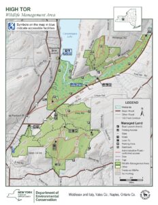 Next Sunday’s hike will take us to this Wildlife Management area run by the DEC Division of Fish and Wildlife for the purposes of conservation and recreation. A “tor” is by definition a hill or mound, therefore not much flatland for hikers. However, I have done my best to accommodate our 3 levels of hikers for this outing.
Meeting Place Large parking area on Basset Rd. Naples. From Rt. 21 in Naples, heading south, bear left on Rt. 53.. In about .75 miles, turn left on County Rd. 21. aka Italy Valley Rd. Basset Rd is a left turn, about 2 miles east. The parking area is on the left, about .5 miles down.
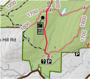
Hiking Groups All hikers will start together on a gravel forest road which leads from the same point in the parking area. We will head north on the gravel road, soon passing through a gate and bear left and pass by two nice ponds, then head uphill on a gradual grade through the woods. When we reach the intersection where the orange trail (the Bristol Hills Branch of the FLT) enters from the left, hikers can split into separate routes.
The Climbers will turn left and follow the orange trail to the first intersection with the blue trail. At that point they will turn to the left to follow the blue trail down to East Hill Rd. Cars will be waiting to ferry climbers back to the Basset Rd parking lot.
The Tourists will turn right to follow the gravel road east to a gate, where they will turn right to head back down to the parking lot.
Meanwhile the Naturalists will continue straight on the gravel road. They may continue to the DEC lean to with an overlook of Canandaigua Lake. But the Naturalists should check their watches and turn about to arrive back at the parking lot at around 4:00.
Social Following the hike we will meet at Middletown Tavern on the corner of Main Street (Rt 21) and Clark St. (Co.Rd 36).
Directions: From the intersection of NY 21 and NY 53 at the south end of Main St in Naples, follow NY 53 south for 0.8 miles. Turn left onto Italy Valley Rd (CR 21). In 2.1 miles turn left onto Basset Rd. In 0.3 miles and after the road turns right, the parking lot will be on the left.
Directions to the social: Follow Basset Rd, Italy Valley Rd and NY 53 back to Naples. Continue straight onto NY 21 (Main St). The Middletown Tavern is on the left across from the gas station..

Looking for brochure.or mailing list so I can receive it in the mail.
Nothing opens up for mailing list.
There’s all kinds of very bizarre ads and post for viagra and other drugs above on calender page.
Please let me know if there’s a brochure available