
Hikes led by Springwater Trails are generally held on Sunday afternoons and appear in this calendar in green.
| Sun | Mon | Tue | Wed | Thu | Fri | Sat |
|---|---|---|---|---|---|---|
| Lehigh Valley Trail Hike or Bike in Rush, NY 2:00 pm Lehigh Valley Trail Hike or Bike in Rush, NY @ Stevens-Connor Lehigh Valley Lodge Apr 6 @ 2:00 pm – 4:00 pm Come join us for a leisurely hike or bike along the Lehigh Valley Trail on Sunday April 6th! With its flat even surface, the trail is a hidden gem for walking, hiking, jogging, biking. It is a vital link in … Continue reading | ||||||
| Ontario County Park at Gannett Hill Hike-Naples 2:00 pm Ontario County Park at Gannett Hill Hike-Naples @ Lookout Parking area Apr 13 @ 2:00 pm – 4:00 pm  This is one of our group’s favorite hikes! Ontario County Park at Gannett Hill is one of the highest points in Ontario County and located in the scenic Bristol Hills. At an elevation of 2,256 feet above sea level, you’ll … Continue reading | ||||||
| No Hike-Easter Break 2:00 pm No Hike-Easter Break Apr 20 @ 2:00 pm – 4:00 pm No hike has been scheduled for this date due to the Easter Holiday. Enjoy the break, spend time with loved ones and eat chocolate bunnies. This will give you something to burn off next week  | ||||||
| Rob’s Trail – Hemlock Lake side 2:00 pm Rob’s Trail – Hemlock Lake side Apr 27 @ 2:00 pm – 4:00 pm Join us on Sunday April 27 to hike the west side of Rob’s Trail, the DEC/Nature Conservancy property in the northeast corner of Hemlock Lake. Options are to hike out and back to the south along the trail from the … Continue reading |
 In the spirit of Earth Day, which was started in 1970 and is now observed in 193 counties across the globe to demonstrate support for environmental protection, on Sunday we will pick up roadside litter along a stretch of Route NY15 in the Town of Springwater. Now in our sixth year of the NYSDOT highway adoption program, we will be working along that section of road between the Springwater Fire Hall and the Steuben County Line. Meet at the Springwater Fire Hall parking lot at 2PM for a safety briefing. Safety vests, hard hats and collection bags will be provided. You will want to bring gloves and work boots. Bags will be left on the side of the road for pick up by NYSDOT. Participants will need to follow COVID safety guidelines.
Directions: The Springwater Fire Hall is on the east side of Route NY15, 0.6 miles south of the flashing light in Springwater,
 Please note the early start time for this hike – we’re starting at 1:00pm because there are 7 fallen trees to deal with.
We need as much help as we can get on this maintenance hike! In addition to the fallen trees we would like to re-route a short section of the trail, and also improve the blazes at several points. We need as much help as possible to share the burden of all the tree cutting and painting gear
The walk this Sunday will be a maintenance hike of our section of the Bristol Hills Branch of the Finger Lakes Trail in Naples. Springwater Trails has signed up with the FLT to maintain this part of the trail. This segment passes through the West Hill Preserve off Seman Rd and then across private land to Mt Pleasant Street in Naples. The Twisted Branch Trail Run comes over this section later in the year; a couple of hundred runners will be pounding the hill and we want to be sure the trail is safe and fun to run.
Mark and Linda pre-hiked it, and there is little to do before the sign-in box at the end of Nature Conservancy land. We will walk this stretch of the BHB and cut away any brush and weeds that have overgrown the path. The most useful tools for this are lopers and a small saw. Be sure to wear good work or gardening gloves. It’s a fairly long hike and steeply downhill at the Naples end of the walk.
We will meet at the entrance to the West Hill Preserve on Seman Road (42.66166, -77.396288). We will shuttle some cars down to the hike end in Naples (42.625950, -77.397304) before we start. The climbers will follow the trail down to the old Pioneer cemetery in Naples. Naturalists follow the trail to the sign in box and then return to the cars on Seman Road.
Please note: Dogs are not allowed to hike on the Nature Conservancy property.
The Social
With the prevalence of vaccination, we are re-starting our après-hike socials! The venue this Sunday will be at the Neapolitan Pizzeria.at 120 North Main Street in Naples. Please observe the usual COVID precautions – wear a mask whenever it make sense, wash or sanitize hands as often as you can, and maintain a sensible distance with other people – it has been working so let’s keep doing it!
Directions to the Hike Meeting Point:
From Springwater: Head south on NY 15 (for 5.2mi). At the light in Wayland turn left on NY 21N (for 6.7mi). In N Cohocton, turn left to stay on NY 21N (for 4.5mi). In Naples, turn left again to stay on NY 21N (for 1.8mi). On the north side of Naples, turn left on CR12 and head up the hill for 1.9 miles. Take the first left, Rhine St., to the 4 way intersection. Go left onto Seman Rd. Trailhead is about 1/2 mile, by a big sign on the left. Park along the road.
From Honeoye and Naples: Head south on CR 36 on the west side of Honeoye Lake (it’s 13.6 miles from NY 20A, and 1 mile from French Hill Road). Turn left onto Gulick Rd (for 2 mi), then right on Davis Rd (for 0.7mi). At the end of Davis, turn left on W Hollow Rd (CR 33) for 0.5mi, then right on Seman Rd. The Trailhead is about 1 mile, by a big sign on the right. Park along the road.
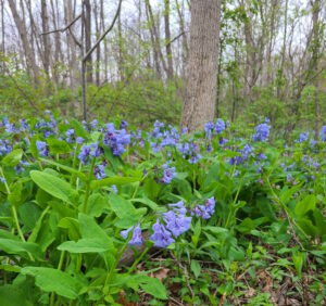 Mother’s Day is traditionally the peak time for the Virginia Bluebells along Mertensia Creek. Bring your mother, or any mother, or just come on your own to the park for a short walk along the creek enjoying the bluebells, followed by a walk or bike ride on the Auburn Trail, which passes through the park. This will be a self-guided event; you can head east through a new section of the Auburn Trail ending at Route 332, or west toward Victor, as far as you’d like and back. Weather permitting, bring a sandwich or snacks to enjoy afterwards beside the creek at the park.
Walkers: All walks are level and on well maintained trails. The distance going east to Route 332 and back is 4.3 miles, including the bluebell circuit. Going west, if you go the full distance to Route 444 in Victor your hike will be about 5 miles including the bluebell circuit.
Cyclists: For those on bikes, heading west to Fishers and back on the Auburn Trail will be 13 miles and will take you to the c. 1841 cobblestone pump house, built to service the steam engines on one of the area’s earliest railroads.
Social: Weather permitting, bring a sandwich or snacks to enjoy afterwards beside the creek at the park. Bring your own lawn chair, as there is only one picnic table.
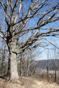
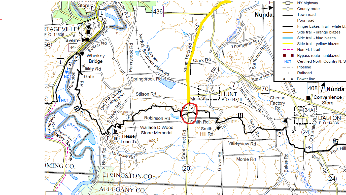 Over the last two years Springwater Trails has held 10 hikes on the Finger Lakes Trail moving west from the Bristol Hills Branch.. We have two more sections, this Sunday and next month, which will bring us to the Genesee River and the Letchworth Branch. Click on the map for a larger view. This Sunday we will hike the section of trail between Dalton NY and Short Tract Rd.
Our best parking seems to be on the shoulder of Short Tract Rd just south of the trail. From Short Tract Rd, we will head east toward Dalton. The hike will be an in-and-out hike avoiding carpooling for what I hope is the last time. (This is a nudge to get your vaccine!).
The hike starts from Short Tract Rd along the left side of a farmed field. As of Thursday, there were no crops in this field, but we will be avoid any crops we may come to, staying at the edge of the fields. Throughout the hike, some blazes are old or missing, but there are enough to ensure we will follow the trail. Stay alert! In a half mile, the trail leaves the field heading left into the woods with nice view of a spring forest. The trail will come out onto Smith Road and turn right onto Smith Hill Road. Both are dirt roads with little traffic and nice views. The trail turns left onto a private driveway and then another left into the wood. Depending on time, I expect the Naturalists and Tourists to turn around at the next cross road to return to the cars. Climbers may have time to continue across the road, but continuing all the way to Hunt Hollow Rd would mean a 5.5 mile hike, probably more than our 2 hour hike.
As of our pre hike on Thursday, the trail was mostly dry, but with all the rain, your boots will occasionally get muddy. Be prepare and you may want hiking polls to assist your footing crossing the mud.
Social: Bring your own sandwich or salad and beverage and we will meet either at the Nunda Kiwanis Park or at the Oakland Locks Parking area. Please bring a chair if you would like to sit.
Directions: Please meet on Short Tract Rd about 300 feet uphill from the trail, where the shoulder is plenty wide in front of flat area in front of a small gravel hill.
From Springwater, Naples, Wayland and Dansville: From Springwater head south on NY 15 to Wayland. From Naples head south west on NY 21 to Wayland. From Wayland, head west on NY 63. In Dansville, at the second light, turn left on Ossian St (NY 36 N). In a half mile, stay straight onto NY 436. Continue for 16.5 miles, through Nunda. The Short Tract intersection is a bit complicated as Short Tract and NY 436 become the same road for 1500 feet. You will pass Short Tract Rd entering on the right. and then pass Crapsey Rd and CR 70 on the left before your left turn onto Short Tract Rd (CR 20). The trail crosses the road in 2.3 miles. Park on the right hand side, heading south a bit uphill past the trail.
From Mt Morris (and Geneseo and Rochester): Head south on NY 408. In 7.6 miles south of Main St in Mt Morris, turn right onto Short Tract Rd. (If you miss Short Tract, turn right on NY 436 at the light in Nunda). In 5.2 miles, turn right onto NY 436, and in 0.3 miles turn left back onto Short Tract Rd. The trail crosses the road in 2.3 miles. Park on the right hand side, heading south a bit uphill past the trail.
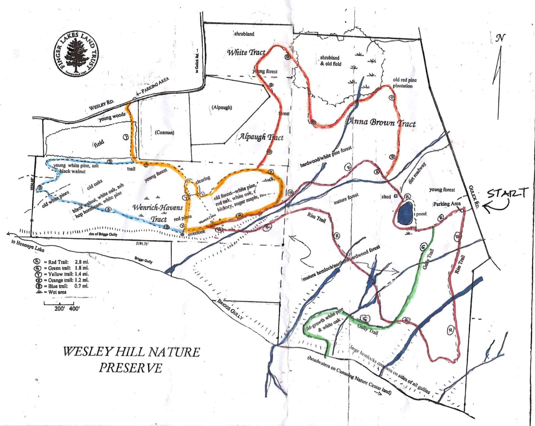 This Sunday we will be doing a hike at the Wesley Hill Nature Preserve on Gulick Road in the town of South Bristol (Naples mailing address). We will meet at the parking area on Gulick Road. Plans for a social gathering following the hike will be announced just prior to the hike, weather permitting and following social distancing guidelines. Please bring lawn chairs if you have them. Check out a history of the Wesley Hill property visit on the Finger Lakes Land Trust website.
The Climber hike will travel south from the parking lot along the red trail for about 8/10 mile until you arrive at the green trail. You will then turn left (west) on the green trail and climb down to Briggs Gully. This is a challenging downhill hike and poles are recommended. We will rest for about 15 minutes at the gully before climbing back up the green trail back to the Gulick Road parking lot. The entire distance for this hike is about 2 miles with a significant climb on the way back to the parking lot.
The Naturalist/Tourist hike will head west from the parking lot on the red/green trail, then turn onto the red trail where the trails separate and head toward the pond. Follow the red trail past the pond, turn left, then right to pick up the orange trail until you arrive at the yellow trail’s split (about 1.39 miles at this point). Turn left at the split and follow the yellow trail to the red trail and turn left onto the red. Follow the red trail back to the pond and the parking lot. This hike is about 2.3 miles in total. There are gentle climbs, some small stream crossings, and great overlooks of the gully. There may be some slippery, muddy spots so poles are recommended.
Directions:
From Honeoye: take route 20A east through Honeoye to East Lake Road. Turn right onto East Lake Road. (If coming from Bristol or points east, it’s a left onto East Lake Road). Take the first left, on CR 33, then the first right onto Pinewood Hill which becomes Gulick Road. Travel about 5 miles to Wesley Hill Parking Area on the right side. Parking lot can fit about 10 vehicles; the rest of us can park on the side of the road (it’s paved).
From Springwater: Head north on Rte. 15A toward Hemlock. Just before Hemlock, turn right on Rte. 20A. Follow Rt 20A to Honeoye and then follow the directions above.
From Naples: From the southern end of Naples, head west on Co Rd 36. Follow Co Rd 36 for 1.2 miles to the first right turn on Gulick Rd. Follow Gulick for about 7 miles. The parking area is on the left.
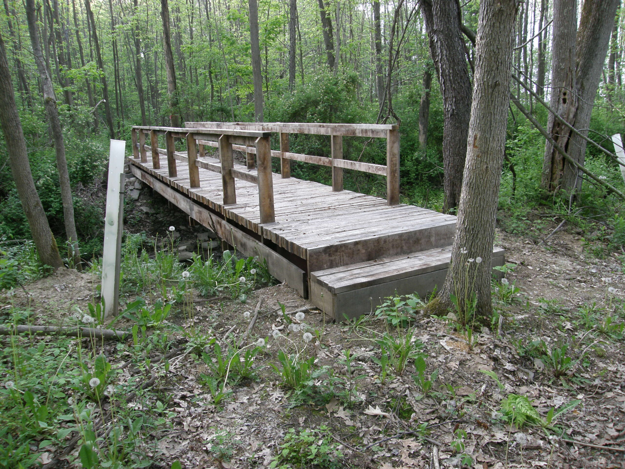
The Mill Creek Bridge
This Sunday’s hike will be on a newly acquired piece of property by the ” Genesee Valley Conservancy”. Mill Creek Nature Preserve attributes its name based on two streams that come together to form Mill Creek. The creek is located in the upper reaches of naturalized brown and native brook trout habitat. The preserve is comprised 47 acres of wooded area with ongoing work to re-establish the natural beauty through conservation effort including controlling invasive species and replacing ash trees being lost to the emerald ash borer.
The hiking trails are a “work in progress” but are fairly cleaned up and are marked. Please stay out of the creek. The trails are normally dry, but if it has rained recently, expect parts of the uphill trail to be a little slick. Long pants and bug spray may be desirable. The lower sections of the trail are relatively flat with some uphill climbs toward the back trail.
After the hike, come warm up at Laf a Lot on Loon Lake.
There is a small parking area in the woods big enough for about 6 cars.
Directions: Mill Creek Preserve is 1.7 miles south of I-390 on NY 21. You will see a short guard rail protecting a culvert, and the driveway to the preserve is immediately after the guard rail on the right side of the road. Park up the driveway or on the shoulder of NY 21.
FROM NAPLES– Head south on Route 21 toward Wayland. Turn left at the first red light. Continue on 21 South about 3.6 miles. Mile Creek Preserve will be on your right.
FROM SPRINGWATER– Head south on Route 15 toward Wayland. In Wayland, go straight through red light and drive another 3.6 miles on Route 21. Mill Creek Preserve will be on your right.
FROM ROCHESTER– Get on 390 south and drive to the Wayland exit . Turn right on Route 21 south for 1.6 miles. Mill Creek Preserve is on your right.
Please note: there is a start time change from the earlier published calendar. This will be the last spring hike with a 2PM start time, and the first SWT event of the year to offer a dish-to-pass social option.
Gene and Georgia Binder are inviting all hikers to join us this Sunday, June 6, at Durand-Eastman Park and arboretum, located on the shore of Lake Ontario. Most of us find this facility, with its unique botanical collection, to be quite enjoyable. Carpooling is advisable if you feel comfortable with it.
Hike Plan: We will start at the circle at the south end of Log Cabin Road, a dead end road on the south side of Lakeshore Boulevard, west of Zoo Road. The full group will begin with a leisurely walk to the arboretum, and into it, enjoying the botanical specimens we encounter. A special feature, at this time, will hopefully be the attractive pink flowers of the mountain laurel, which goes into bloom in June. These flowers have a unique way of getting bees to transfer pollen and, if there are any open flowers, we will try to demonstrate their sneaky trick. For those who would prefer a longer and faster hike, the arboretum walk will be followed by a longer trail walk around Durand and Eastman Lakes.
Social: We will all convene back at the circle on Log Cabin Rd., at 4 PM, for our optional after-hike social. If you’ve been vaccinated, and feel comfortable with it, we will go back to enjoying each other’s kitchen creations, like we used to, so bring something yummy to share with your fellow hikers. As before the pandemic, place settings will be provided. If you’re not yet comfortable doing this, just bring your own meal, as you’ve been doing. If there’s an unoccupied pavilion, we will appropriate it. However, if they’re all occupied, we’ll just put our chairs out on the lawn so, be sure to pack a folding lawn chair. We will pack a folding table and, if you have one that you can fit in, we may be able to use it. We don’t have a portable grill but, if someone has one and wants to bring it, go for it. There will be a small charcoal grill if you want to cook burgers and such.
Directions: Going north on 390, entering Monroe County, at the first fork, bear right to get on 590. At the next fork, bear left to stay on 590. Continue north in the center lane. When approaching 104, follow signs for sea breeze, avoiding 104 exits. Approaching the fourth roundabout, note sign for Durand Blvd. Go ¾ way around to get on Durand Blvd. Continuing west, you will come to the park, on your left. Turn left on Log Cabin Rd., the3rd road on your left. Go to the circle at the end of Log Cabin Rd., and park. We will meet there.
This Sunday we have a choice of activities, both starting from the northeast corner of Honeoye Lake – a hike on Sandy Bottom Trail and its adjacent creek, or a bike ride along or around Honeoye Lake. Note the later start time of 4 PM for both activities. After the workouts we will adjourn to the Birdhouse Brewing Company at 8716 Main Street, Honeoye for our social/recuperation.
Everyone meets at the Sandy Bottom Trailhead on East Lake Road, about .3 mile from Route 20A/Main Street Honeoye. There are two parking lots side-by-side, each holding about 10 cars. Hikers will all start out together on the field portion of the trail and then there are options: head down the path to the long winding creek for a creek walk to explore some of the most interesting rocks in the area, and fossils here and there as well. Or, continue walking the field loop into the woods loop and back out to finish the field loop (about 3 miles), then head down to explore the creek. There are plentiful treasures to see! Recommended attire – sturdy shoes with decent treads, walking sticks for creek with slippery stones.
For the cyclists there are two options:
-10 mile ride down East Lake Road to the South Boat Launch (5 miles) and return the same way, or
-18 mile loop ride around the lake clockwise, heading down East Lake Road to the South Boat Launch, heading further south to join County Road 36 (West Lake Road), and riding north back to Main Street/NYS Route 20A. Heading a mile east on Main Street and then .3 miles down East Lake Road will bring you back to the start.
Cyclists please bring plenty of water, and helmets are required.
Social: Please join us afterwards at the BirdHouse Brewing Company, 8716 Main Street, Honeoye, for restorative food and beverages. See their Sunday Grill specialties at https://birdhousebrewing.beer/index.php/from-the-kitchen/sunday-grill
Directions:
From the south (Naples, Springwater, etc): Take Rte 21 North to CR 36, make left onto CR 36, make right onto East Lake Road – parking lot is on left just past the County Road 33 intersection.
From the north (Bloomfield, Victor, Rochester, etc): Take CR 40 south to Rte 20A, cross 20A onto East Lake Road, parking lot is on right, 3/10 of a mile from intersection.
From the east (Bristol, Canandaigua, etc): Take Rte 64 south to Rte 20A, make right onto 20A, left onto East Lake Rd
From the west (Hemlock, Livonia, etc): Take Rte 15A to Route 20A, make left onto 20A, right onto East Lake Road
This Sunday’s hike will complete Springwater Trails tour of the Finger Lakes Trail between the Bristol Hills Branch and the Letchworth Branch. This hike should be an enjoyable end to the series, walking through some interesting landscape carved by the Genesee River, with views from high above the Genesee River. 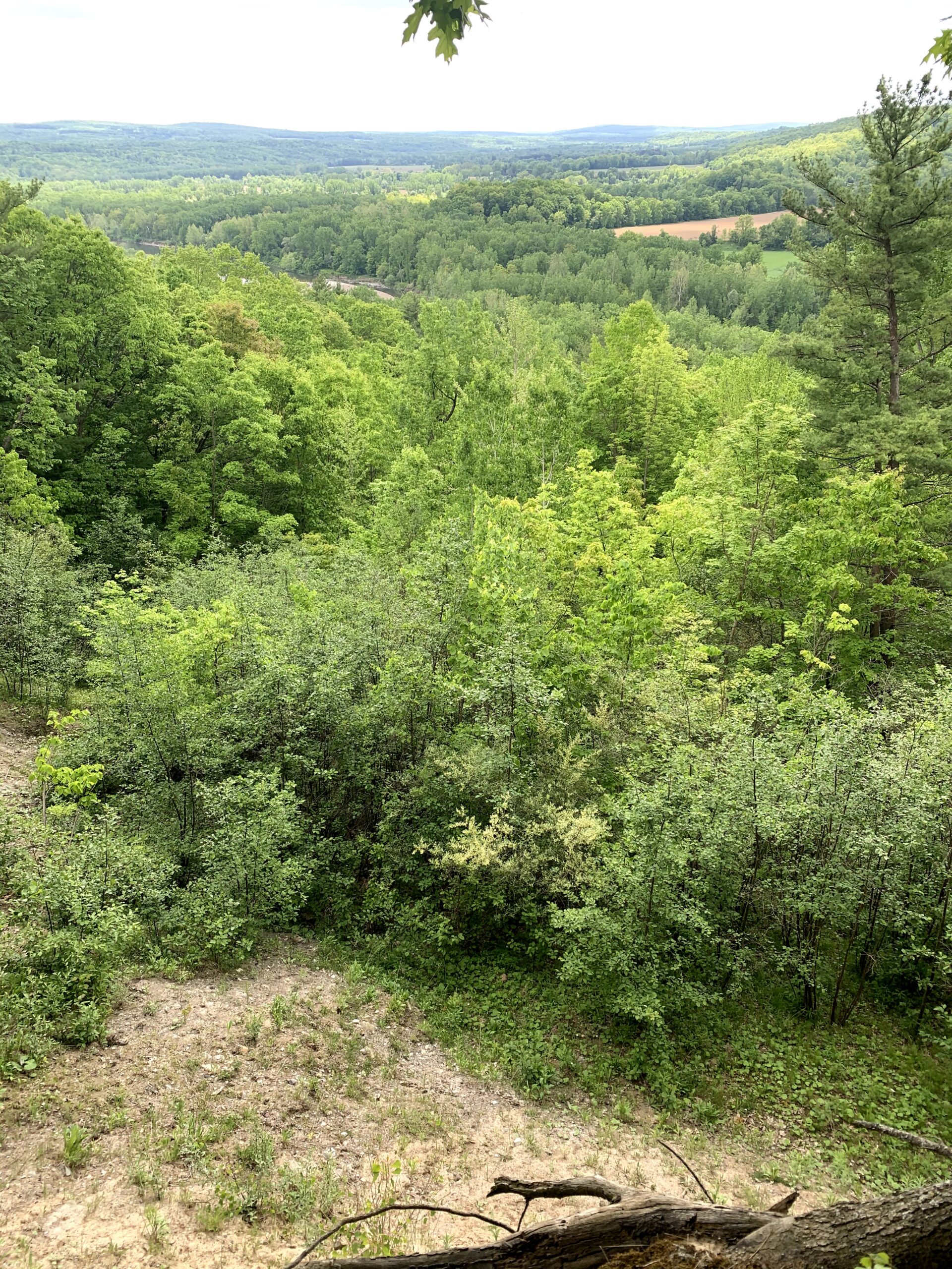
We will all meet at the Whiskey Bridge across the Genesee River. According to the Briidgehunter website, local legend gives two possible origins for “whiskey” bridge: the Irish immigrants who built the bridge drank so much whiskey it was called whiskey Bridge; OR Livingston county was “wet” and Wyoming county was “dry”, so whiskey was hidden under bridge and smuggled across.
At any rate, the bridge was lost in 1972 to the Agnes hurricane and was replaced by a “through truss” bridge we will see on Sunday.
After our group picture by the bridge, we will car pool to S. River Rd to start the hike. The hike starts in the woods, with interesting plants on either side, including – according to the FLT map description – some poison ivy. The trail continues along a sharp ridge with views to the south and west across the river valley. We will sign in at the register before beginning a gradual descent through some recent logging and past farmer’s fields. The blazing of the trail along the farmer’s road is occasionally difficult to follow, including at a left turn to follow the road down hill along the edge of a slope.
After passing farm equipment and buildings, we will emerge onto Bailey Rd. A left turn out of the gate will follow Bailey Rd up to Whiskey Bridge and our cars. We will walk across the bridge and check out the connections to the Genesee Valley Greenway, the FLT Letchworth Branch and the main Finger Lakes Trail in Wyoming County. The total hike is about 2.5 miles.
After a carpool back to pick up cars left on S River Rd, thirsty hikes can cross the bridge and head north to the Letchworth Pines in Portageville.
Directions:
From Springwater: Take NY-15 south to Wayland. Turn right on NY 63 to Dansville. Turn left onto Ossian St (NY 36 North). In half a mile, continue straight on Ossian St onto NY 436 W. In 19 miles, after passing through Nunda and continuing past an entrance to Letchworth State Park, to cross the Genesee River into Portageville, turn right to stay on NY 436. Rt 436 ends at NY 19A. Turn left on 19A for 0.7 miles. Turn left onto Bailey Rd and cross the Whiskey Bridge. Turn left onto Bolton Rd and park.
From Geneseo: Take NY 63 S toward Mt Morris. Curve left to continue on NY 408 under I-390 Continue on NY 408 for 13.3 miles through Mt Morris to Nunda (there is a left then right jog at Main St in Mt Morris to stay on 408). At Nunda, turn right on NY 436W for 6 miles through Portageville. Turn left on 19A for 0.7 miles. Turn left onto Bailey Rd and cross the Whiskey Bridge. Turn left onto Bolton Rd and park.
From Hornell: Head north on NY 36N for 10 miles. Turn left onto CR 70 for 10.2 miles. You will pass the intersection with NY 408. followed by Oakland Rd. Turn left onto CR 2 (Main St). In 1.3 miles, turn left on Short Track Rd, then right onto Stillson Rd. In 1.2 miles, turn right onto Pennycook Rd, then left onto Bailey Rd. In 1.7 miles, pass the bridge and park.
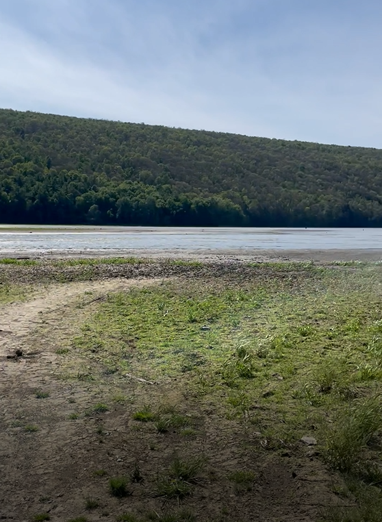
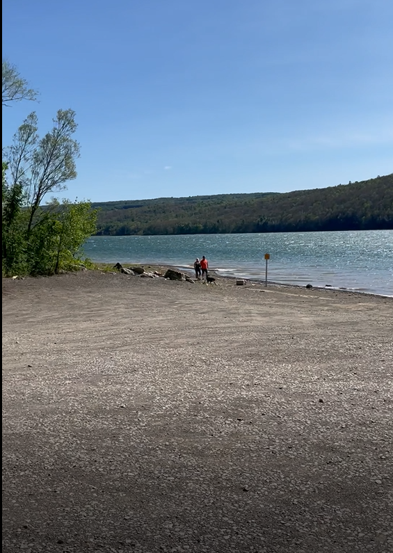 This Sunday we will be hiking and boating on Hemlock Lake. As always, please check back here before the hike in case of bad weather.
We will all meet at the North Boat Launch on Hemlock Lake. Boaters should arrive 15 minutes early to allow time to unload boats. The launch has been expanded since last summer, so unloading should be quite easy. Hikers will follow the trail south along the lake and can continue up Rob’s trail if time permits. Hikers should return to the cars by 6:00 PM, either along the trail or along the shore line (the lake is low enough to allow walking next to the water).
Boaters will explore the north end of the lake. We will make a loop, crossing the lake once each direction. If desired, some hikers will plan to meet a boat at the Rob’s Trail beach and trade transport with a boater.
 Following the hike, we will enjoy an optional pot-luck supper at the Hemlock Park pavilion. Bring your own beverage, a dish to pass, and, if you prefer, your own reusable plate and silverware.
Directions are available here.
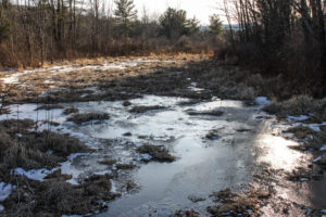
One final note: With the low water on Hemlock, the south boat launch appears to be unusable. See the image to the left.
Looking for brochure.or mailing list so I can receive it in the mail.
Nothing opens up for mailing list.
There’s all kinds of very bizarre ads and post for viagra and other drugs above on calender page.
Please let me know if there’s a brochure available