
Hikes led by Springwater Trails are generally held on Sunday afternoons and appear in this calendar in green.
Well, annually, November 17th is National Take a Hike Day. So, for some “in-touch time”, consider grabbing one or more friends, or for some solitude “in-touch time” consider heading out solo, for a hike.
In 2016, November 17th happens to be a Thursday. Can’t get out and hike on this day? Well, it is just a day, like any other. So if this day of recognition does not work for you, get out and take a hike on a day that does work for you.
But, then, I’m preaching to the choir. Am I not?
Perhaps you may want to spread the word and share a hike with someone who normally would not get out and do a hike on his/her own.
See you Sunday?
Happy Hiking!
 The Penfield Trails Committee will host its annual ‘Indoor Hike’ on Saturday, February 11, 10:00 am at Penfield Town Hall Auditorium, 3100 Atlantic Avenue. There will be a presentation entitled “Letchworth’s Portage Viaduct – New and Old”, information on trails groups from around the Rochester area, and light refreshments will be served. This event is free.
Please click on the poster to the right for a full size version.
Chris Costello, professional land surveyor, will speak about the 1875 Portage high bridge / railroad viaduct high above the Genesee River in Letchworth State Park. Costello will give an inside look at the construction of the new bridge in progress. Learn the history and the future of Letchworth rails and trails. Hikers, history buffs, and rail fans – lace up your boots and join us!
“This year’s speaker will give participants a rare behind-the-scenes glimpse of the much anticipated construction of the new railroad bridge,” says Nels Carman, Penfield Trails Committee chair. “This iconic structure has an interesting past and a promising future.”
While the “hike” is free, participants are asked to pre-register by calling Penfield Recreation at 340-8655, option 0. (requested, albeit not required)
Penfield Trails Committee is always seeking volunteers to serve on its planning committee, as well as to do manual labor for trails maintenance. For more information, please call Penfield Recreation at (585) 340-8655.
For general information – Penfield Trails Committee leads one guided hike per month March through January, and the twelfth hike of the year is the annual ‘indoor hike’ in February.
Springwater Trails Note: Following the “indoor hike”, there are two hikes that Springwater Trails hikers can take advantage of. A strenuous 5-6 mile hike at Lucien Morin Park, 1131 Empire Boulevard, Rochester, will be hosted by the Genesee Valley Hiking Club. And ST’s own, Gene will be leading a shorter hike at Ellison Park. Both hikes start at 1:00. So, come and enjoy the Monroe County Parks. An after-hike social will be held ~ 3:330PM at MacGregor’s loacted at 1129 Empire Blvd (next to Lucien Morin Park).
 The hike series will be held on the second Saturday of each month, April through October 2017. Each month a different section of trail will be the hike/bike. In 2017, the chronological monthly hike will steadily progress southward in section of trail hiked.
In 2017 the Genesee Valley Greenway State Park (GVGSP or GVG) hike series continues, very similar to albeit separate from the 2015 & 2016 two year initiative for GVGSP hike series.
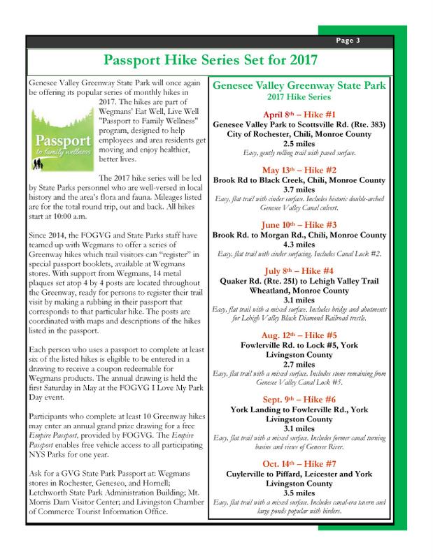
Passport Hike Series 2017 of the Genesee Valley Greenway State Park (GVGSP or simply GVG) includes seven guided hikes, one each month April thru October inclusive, each hike is on the second Saturday morning of each respective month. Each month’s hike covers a different section of the GVG.
Past years’ hikes: The 2015/2016 two year hike series scheduled one hike per month, April through October, 7 hikes per year offered usually on the second Saturday of the month, and as a guided hike by park staff. (Back in 2014 there were some GVG hikes led by park staff as well, one per calendar quarter.)
A brief primer of the GVG: The GVG is a linear state park which approximately follows the alignment of the former Genesee Valley Canal. Following closure of the canal the traverse (mostly the towpath of the canal) would subsequently become the bed of the Genesee Valley Canal Railroad which eventually became part of the Pennsylvania Railroad system. In the years after the abandonment of nearly all that railroad alignment there became impetus to utilize the alignment as a multi-use trail. Through cooperative efforts among a number of groups/organizations/and individuals that impetus became reality, and eventually the GVG became the GVGSP.
HIKE DATES AND LOCATIONS FOR 2017
Saturday, April 8th, 2017 – Hike #1. Genesee Valley Park to Scottsville Rd (Rt. 383), City of Rochester, Chili, Monroe County, 2.5 miles. Easy, gentle rolling trail with paved surface.
Saturday, May 13th, 2017 – Hike #2. Brook Rd to Black Creek, Chili, Monroe County, 3.7 miles. Easy, flat trail with cinder surface. Includes double-arched Genesee Valley Canal culvert (aka aqueduct).
Saturday, June 10th, 2017 – Hike #3. Brook Rd to Morgan Rd, Chili, Monroe County, 4.3 miles. Easy, flat trail with cinder surfacing. Includes Genesee Valley Canal Lock #2.
Saturday, July 8th, 2017 – Hike #4. Quaker Rd (Rt 251) to Lehigh Valley Trail, Wheatland, Monroe County, 3.1 miles. Easy, flat trail with a mixed surface. Includes bridge and abutments for Lehigh Valley Black Diamond Railroad trestle.
Saturday, August 12th, 2017 – Hike #5. Fowlerville Rd to Lock #5, York, Livingston County, 2.7 miles. Easy, flat trail with a mixed surface. Includes stone remaining from Genesee Valley Canal Lock #5.
Saturday, September 9th, 2017 – Hike #6. York Landing to Fowlerville Rd, York, Livingston County, 3.1 miles. Easy, flat trail with a mixed surface. Includes former canal turning basins and views of the Genesee River.
Saturday, October 14th, 2017 – Hike #7. Cuylerville to Piffard, Leicester and York, Livingston County, 3.5 miles. Includes canal-era tavern and large ponds popular with birders.
INFORMATION ABOUT WEGMAN’S GVGSP PASSPORT BOOKLETS
Genesee Valley Greenway State Park will once again be offering it popular series of monthly hikes in 2017. The hikes are part of Wegmans’ Eat Well, Live Well “Passport to Family Wellness” program, designed to help employees and area residents get moving and enjoy healthier, better lives.
The 2017 hike series will be led by State Parks personnel who are well-versed in local history and the area’s flora and fauna. Mileages listed are for the total round trip, out and back. All hikes start at 10:00AM.
Since 2014, the Friends of the Genesee Valley Greenway (FOGVG) and State Parks staff have teamed up with Wegmans’ to offer a series of Greenway hikes which a trail visitor can “register” in special passport booklets, available at Wegmans’ stores. With support from Wegmans, 14 plaques set atop 4 by 4 posts are located throughout the Greenway, ready for persons to register their trail visit by making a rubbing in their passport corresponding to that particular hike. The posts are coordinated with maps and descriptions of the hikes listed in the passport.
Each person who uses a passport to complete at least six of the listed hikes is eligible to be entered in a drawing to receive a coupon redeemable for Wegmans’ brand products. The annual drawing is held the first Saturday in May at the FOGVG I Love My Park Day event.
Participants who complete at least ten Greenway hikes may enter an annual grand prize drawing for a free Empire Passport, provided by FOGVG. The Empire Passport enables free vehicle access to all participating NYS Parks for one year.
Ask for a GVG State Park Passport at: Wegmans’ store in Rochester, Geneseo and Hornell; Letchworth State Park Administration Building; Mount Morris Dam Visitor Center; and Livingston Chamber of Commerce Tourist Information Office.
How the land was acquired.
The Genesee Valley Greenway follows the towpath of the former Genesee Valley Canal (1840-1878) and Pennsylvania Railroad, Rochester Branch (1882-1963). In 1963, RG&E purchased portions of this corridor.
It later sold sections to the NYS Office of Parks, Recreation, and Historic Preservation (OPRHP). The Department of Environmental Conservation (DEC) became involved as co-sponsor of a federal grant that was used to acquire additional land, expanding the corridor north through Livingston County and south to Hinsdale.
How the Greenway got its start.
New York Parks and Conservation Association (NYPCA) introduced the idea in 1991 after it first established interest among local government officials, user groups, environmentalists, and local businesses.
Guided by a 40-member steering committee and a NYPCA Local Coordinator, individual sections of the trail opened for public recreational use in 1992.
A Public-Private Partnership.
The Friends of the Genesee Valley Greenway grew out of the interest and enthusiasm generated by initial trail development efforts. Incorporated in 1993, it has since devoted its efforts to developing additional owned miles and maintaining existing miles of open (or usable) trail.
FOGVG also preserves and interprets historic and natural resources along the Greenway, and develops communications, programs, activities, and community partnerships to stimulate increased use and enjoyment.
A partnership between FOGVG, OPRHP, and DEC began in 1994 when these entities co-authored a successful $2.1 million federal Transportation Enhancement grant. Each partner contributes unique and important resources to the Greenway.
UPDATE – TUESDAY MAY 2ND, TRAIL CONDITIONS: It will be muddy and wet, no chance of staying dry this year at the Bluebell hike. Perhaps Traction Devices &/or gaiters may be desirable for use, &/or waterproof boots.
Please feel free to join our friends of Genesee Valley Conservancy aka “GVC” (which has offices in Geneseo, NY) for its annual Bluebell hike(s). Each hike, one at 10:00AM and another at 2:00PM will be ~ 1.5-2 hours in duration and cover ~3.5 miles. Trail conditions may be muddy, so dress accordingly, TDs (Traction Devices) may be helpful.
This hike is a rather unique opportunity! And … you’re invited! You’ll marvel in the wonders of the blooms on Bluebells at this time of year, and as well traverse an area where normally hikers can not, as this hike on private property has been arranged exclusively for this GVC annual Bluebell hike (walk) event.
Hike location is at 3432 Nations Rd, Geneseo, NY.
Approx GPS Coords = 42.829918, -77.803816
Please note: hike times which start respectively at 10:00AM & 2:00PM are scheduled for just one day, Saturday , May 6th, 2017. Miss the date and you’ll need to wait a year for the hike opportunity to roll around again. Please realize that Mother Nature does not always cooperate with preplanned dates with design to showcase Natural Splendors. Advance predicted timing of Bluebell flowers blooming can be a tenuous undertaking, especially so in some years where weather patterns are substantially outliers from the norm.
Hike Location: Nations Rd runs, in an overall ~ “L” shape, westerly off NY Rt 39 (aka Avon Rd, and aka Avon-Geneseo Rd) a bit north of the Village of Geneseo, and also runs southerly off Co Rd 22 (aka Fowlerville Rd) in the western reaches of the Town of Avon. (The shortest entry to the hike locale from a main road is from NY Rt 39.) The hike location at 3432 Nations Rd is on the approximately e-w traversing section of Nations Rd, not far from the angular corner with the n-s traversing section of Nations Rd. Parking is with judiciousness and courtesy along the side of Nations Rd.
Directly extracted from the GVC website, below is the hike description provided by GVC.
_____________________________________________________________________
Bluebell Hike

This 3.5 mile hike takes place on trails that will be muddy and includes hiking through fields and over uneven surfaces. The hike features working agricultural fields and a forest along the Genesee River that is host to a spectacular sea of Common Bluebell flowers. The hike will take between 1.5 and 2 hours.
The hike will depart rain or shine. There is no transportation available. Participants must be able to complete the round trip.
The hike takes place on private property. Please help us continue this event by only visiting with us during these scheduled times.
*Event supported by Steuben Trust Company
UPDATE – TUESDAY MAY 2ND, TRAIL CONDITIONS: It will be muddy and wet, no chance of staying dry this year at the Bluebell hike. Perhaps Traction Devices &/or gaiters may be desirable for use, &/or waterproof boots.
Please feel free to join our friends of Genesee Valley Conservancy aka “GVC” (which has offices in Geneseo, NY) for its annual Bluebell hike(s). Each hike, one at 10:00AM and another at 2:00PM will be ~ 1.5-2 hours in duration and cover ~3.5 miles. Trail conditions may be muddy, so dress accordingly, TDs (Traction Devices) may be helpful.
This hike is a rather unique opportunity! And … you’re invited! You’ll marvel in the wonders of the blooms on Bluebells at this time of year, and as well traverse an area where normally hikers can not, as this hike on private property has been arranged exclusively for this GVC annual Bluebell hike (walk) event.
Hike location is at 3432 Nations Rd, Geneseo, NY.
Approx GPS Coords = 42.829918, -77.803816
Please note: hike times which start respectively at 10:00AM & 2:00PM are scheduled for just one day, Saturday , May 6th, 2017. Miss the date and you’ll need to wait a year for the hike opportunity to roll around again. Please realize that Mother Nature does not always cooperate with preplanned dates with design to showcase Natural Splendors. Advance predicted timing of Bluebell flowers blooming can be a tenuous undertaking, especially so in some years where weather patterns are substantially outliers from the norm.
Hike Location: Nations Rd runs, in an overall ~ “L” shape, westerly off NY Rt 39 (aka Avon Rd, and aka Avon-Geneseo Rd) a bit north of the Village of Geneseo, and also runs southerly off Co Rd 22 (aka Fowlerville Rd) in the western reaches of the Town of Avon. (The shortest entry to the hike locale from a main road is from NY Rt 39.) The hike location at 3432 Nations Rd is on the approximately e-w traversing section of Nations Rd, not far from the angular corner with the n-s traversing section of Nations Rd. Parking is with judiciousness and courtesy along the side of Nations Rd.
Directly extracted from the GVC website, below is the hike description provided by GVC.
_____________________________________________________________________
Bluebell Hike
This 3.5 mile hike takes place on trails that will be muddy and includes hiking through fields and over uneven surfaces. The hike features working agricultural fields and a forest along the Genesee River that is host to a spectacular sea of Common Bluebell flowers. The hike will take between 1.5 and 2 hours.
The hike will depart rain or shine. There is no transportation available. Participants must be able to complete the round trip.
The hike takes place on private property. Please help us continue this event by only visiting with us during these scheduled times.
*Event supported by Steuben Trust Company
So, you’ve been itching to get on your bike this Spring with impetus of a group bike outing of some kind. Well, here is an opportunity to do just that … on the Genesee Valley Greenway (GVG) from Avon to York Landing (round trip) on Saturday May 20th, 2017 at 10:00AM. Approximately a 17 mile round trip easy paced bike ride, and all trail mileage covered is in the nw corner of Livingston County. Meet location is at the Erie-Attica Trail (EAT) trailhead in Avon, accessed by Farmers Road off Rts 5&20 just east of the Genesee River.
– – – A digression – – Speaking of itching, this Hike Planner has had impetus to utilize the section of the GVG shortly north of Fowlerville Rd (and south of US Rt 20), said section has a short duration of trail topped with thick stone dust (mostly fine stone sans dust), for a ST hike since early Spring 2016 just following reconstruction of said section of trail which had been necessitated as result of a huge washout area. The thick stone dust topper (as determined during a potential preview hike in April 2016), provided wonderful cushioning upon a hikers joints, albeit bike/stroller/wheelchair wheels found much friction/consternation due to sinking in the freshly laid thick topper surface.
Due to complaints of wheeled trail users, later in 2016 the topper surface was rolled by a heavy duty roller to make for some compaction factor, and the surface is said now to be kinder to the aforementioned narrow wheeled vehicles (and probably offers less of an exuberant opportunity for a hiker’s joints). If there is a lesson here, perhaps it is that not all opportunities are lasting, some have but a small window of opportunity. Still, a future ST hike planned to utilize this section of the GVG may offer multiple unique opportunities including this now somewhat tamed section of thick stone dust topper.
Anyway, you’ll get to see this short section and so much more of the GVG via your bike on this traverse much more quickly than while on a hike. – – –
(A further digression, …for the curious, … utilization of the aforementioned section of trail south of US Rt 20 was in consideration for the 4/24/2016 ST hike, but ultimately was scrapped from the fledgling Hike Plan due to what would have been a controverted driving route to reach the GVG trailhead parking lot on US Rt 20, all thanks to road reconstruction on US Rt 20 just east of the GVG trailhead. -Now you know – substantially trials and tribulations that weighed in nixing this unique section of trail south of US Rt 20 for the 4/24 ST hike, … instead all hiking groups headed north from Avon.) – – – End of digressions. – – –
GETTING THERE:
From just inside Avon’s western town limits, to reach the Erie-Attica Trail parking lot & trailhead follow Farmers Rd to the end where you’ll find both the parking lot & the trailhead. – – – Seem familiar? Well, ST has in the past (10/18/2015 hike) held a hike utilizing exactly this trailhead and parking lot, as well as parts of the connecting GVG, so yes, it may seem familiar. And an April 24th 2016 ST hike also utilized the GVG in this area.
Detailed Directions From Springwater: Take Rt 15A North. In Lima, turn left on US Rt 20 (concurrent NY Rt 5, thus known as Rts 5&20). Follow Rts 5&20 for 7.6 miles (you will cross over I-390, pass through the hamlet of East Avon and the Village of Avon. After the traffic circle in the village, continue on Rts 5&20 for 0.8mi and turn right on Farmers Rd. The parking area is on the right, just after you pass under the flyover for the former RR truss bridge (now the Erie-Attica Trail truss bridge).
Further Event Details for this May 20th biking event are listed on the FOGVG Facebook page.
GVG Passport Booklet: This bike ride will cover a stretch of trail where you’ll be able to avail yourself of making a rubbing in the Wegman’s Passport to Family Wellness – GVG passport booklet. For those unfamiliar – – – Wegmans – “Passport to Family Wellness Program” series booklet for the Genesee Valley Greenway is a passport compilation of 14 separate hikes on the GVG, each hike route having a “rubbing post” for trail users to produce a “rubbing” in their passport booklet with purpose of documenting that a trail user has completed the respective hike. Passport booklets filled-in with rubbings can be turned in at a Wegmans retail store for redemption of coupons for Wegmans brand products and entry for a prize drawing. So, remember to bring your GVG passport booklet on this bike ride.
(Event post initially published on 5/7/2017, updated 5/17/2017.)
Annually, one of two big shindigs (of a hiking variety) that Victor Hiking Trails (VHT) sponsors, is National Trails Day (NTD) observed the first Saturday of June. In 2017, the 25th year for this event in Victor, the date is June 3rd and the starting location is at Ganondagan State Historic Site Visitor’s Center located at 7000 Boughton Hill Road (County Road 41) .
VHT is of course one of many hiking groups that plans some organized observance on NTD. Yep, that word “national” does in fact imply many groups across the USA observe or celebrate NTD in some manner. Now, before I describe more about NTD activities, you were wondering what the other big shindig that VHT has annually. Weren’t You? Answer: the second big shindig VHT does is the VHT “Challenge Hike” usually held in late September.
NTD in Victor with VHT is usually three serial hikes, with a break in between each of the three hikes for rest and refreshment. The first hike is a morning hike and the last hike finishes in the afternoon.
You can read about National Trails Day from 2017 in the the VHT newsletter The Pathfinder Spring 2017 edition (volume 22, issue 1, page 1). And of course, you can check the VHT website for updated details about the NTD hike for June 3rd, 2017.
If you’re Interested in past years NTD in Victor, …two most recent years are cited: National Trails Day from 2016 in the VHT newsletter The Pathfinder 2016 Spring edition , and from 2015 The Pathfinder Spring 2015 edition (volume 20, issue 1, page 6).
Little Rock City (a rather unique hike destination) is located in Rock City State Forest, and as cities go, well, it is not a city in the traditional sense, as occupied by humans, … it is a city of rocks. “Little Rock City” is one of three “Rock Cities” in Cattaraugus County, NY. [For the curious … The other two are: Rock City Park (a privately owned tourist attraction of huge rock formations and more), and Thunder Rocks in Allegany State Park may be considered by some to be a rock city.] Please don’t let “Little” in Little Rock City mislead you, the rocks are actually huge here, the diminutive is likely a mere delineation from the larger “Rock City Park”.
For Sunday, July 2nd 2017, ST has not planned a ST hike (that was announced at the 6/25 ST hike) . BUT WAIT- do not be dismayed, here is a hike opportunity at Little Rock City that some ST hikers may be willing to travel to and find the hike well worth the distance of travel. (This hike opportunity came to ST on Monday morning 6/26, and by Monday afternoon this hike got posted for ST and other hikers too.)
The Finger Lakes Trail (FLT) runs thru Rock City State Forest, as do some other trails. Here is an opportunity to avail yourself of these trails with some like minded hikers.
This is a hike provided by the group Chautauqua Hikes, and likely you’ll be joined by some hikers from Olean Area Hiking Group (yes, the same group that ST did a joint hike with at Hanging Bog three or so years ago). Hikes are open to other hikers.
The two paragraphs below in italics are the hike particulars as provided by “Chautauqua Hikes”.
Come out and join us for a hike at Little Rock City on Sunday July 2nd. Various skill levels are welcome. We will meet at the park and ride on Rt 60 at 9:30am to carpool to the trail. This is a trail that we did a few times years ago but not recently. Bring
a lunch and water. Dress for the weather. The trial is hilly and rocky.
I’m not sure of the distance but we will be out all day, including travel
time.
This state forest received its name due to the massive boulders the size of
houses which are naturally arranged so that they resemble a city with
“streets” running between them. This unique “city” is formed by many
factors including a massive resistant conglomerate bed, erosion of the weak
shale base and soil creep. The conglomerate bed actually has its own
geological designation known as Devonian Salamanca conglomerate. A
conglomerate is a rock consisting of individual stones that have become
cemented together.
– – Please note, the carpool point (park & ride on Rt 60 at 9:30am) listed in the two italics paragraphs above is not one that ST hikers would use, as it is in Jamestown area well west of Little Rock City. ST hikers would be coming from the east.
Basics of this hike – for ST hikers:
Hike start time for this “Little Rock City” hike is targeted as 10:30AM. Hike Leader is Eileen of Chautauqua Hikes. Bring a lunch and water. Dress for the weather. The trial is hilly and rocky. Various skill levels of hikers are welcome.
Parking for this hike and Hike start locale are both at the former CCC Camp Seneca on the west side of Hungry Hollow Rd. Map or GPS coordinates ~ 42.224246, -78.699124
Carpool for ST hikers Carpool (unsupervised) is at Springwater Town Hall with gathering time at 8:05AM and depart time of 8:15AM. (A potential carpool point in Wayland is under consideration at present.)
Driving Directions (from Springwater Town Hall): Drive time to the hike from Springwater is ~ 2 hours. Rt 15 south; to Rt 21 south; to Rt 36 north (very briefly) ; to Rt 17 Southern Tier Expressway (aka I-86) west. From Southern Tier expressway take Exit 23 to Rt 219 north (Business) / Rt 417. From 219 north / Rt 417 turn right onto Killbuck Rd (aka Co Rd 49), which will eventually merge back into Rt 219 north. Continue briefly on Rt 219 north (aka Buffalo-Pittsburgh Hwy, likely named for the routing of the railroad of same name) crossing over Great Valley Creek, then just past Great Valley Creek and the large antique place on the left turn left onto Hungry Hollow Rd. The CCC Camp Seneca parking area is a couple miles down Hungry Hollow Rd on the left/west. – – – Hint:The parking area is a short distance after passing Perrault Rd which intersects Hungry Hollow Rd (on the right/east). If you reach the intersect of McCarthy Hill Rd (on the right/north) while on Hungry Hollow Rd you’ve gone to far.
Map or GPS coordinates (approximate) for CCC Camp Seneca parking area (trailhead access to Little Rock City) ~ 42.224246, -78.699124 ( A reminder: Bear in mind in some areas, especially more remote areas, GPS units may not give accurate routing directions. Oooo, err, uhmm, RECALCULATING. ;~)
– – – (optional, not required) – – – Interested hikers should feel free to “log-in” to the ST website (as an authorized user) and post “comments” to this post (perhaps confirm who is going and advance carpool arrangements, etc). (Alternatively, you may also send an e-mail to: damhikes [at] springwatertrails.org ; and communications efforts can be coordinated via e-mail.)
As a primer, here at two links about Rock City State Forest (and more), both are on CNYhiking website. You’ll find some photos of Little Rock City in the links. – – A shout out of “THANKS” to Ed of CNYhiking for the plethora of fantastic info he has cataloged for use by hikers and other outdoor enthusiasts … all listed in the CNYhiking.com website!
http://www.cnyhiking.com/RockCityStateForest.htm
http://www.cnyhiking.com/NCT-RockCityStateForest.htm
>>> most recent update to this hike event post by author – Friday 6/30/2017 ~ 12:25PM <<<
Please check this post for any additional info or changes as we approach hike day.
Just Sayin’ … after the hike, when returning to the Finger Lakes area, hikers may wish to consider taking in the free concert performed by Bluegrass group “South 79” at Vitale Park located at the head of Conesus Lake in Lakeville. Concert time is 6-8PM. Parking may be a bit of a challenge, … none-the-less an additional chance to kick-back and get in some recreatin’ on a Sunday of Independence Day weekend.
Lastly, a suggestion, toward a future ST hike. … If you go to this Little Rock City hike, perhaps keep a perspective eye toward possibility of planning a future ST hike at Little Rock City, which for sure would be a rare distance travel exception hike for ST if our group decides there is willingness to make the travel.
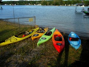
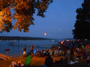
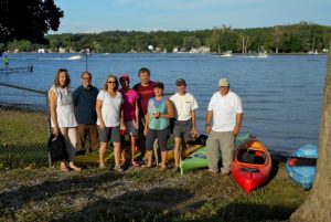 For the last two years the happy kayakers have ventured out into the center of the Annual Conesus Lake Ring of Fire, while others less willing or non-kayakers enjoyed watching the fireworks from the shore. This year Springwater Trails is invited to join the happy kayakers for a picnic at 6:00 at Long Point Park in Geneseo to celebrate the 4th of July. The kayaking will launch at 8:00 and return at 10:00.
Because Conesus Lake can be rough at times and because of the return in darkness, only experienced kayakers will participate. Also, we’ll only kayak if the weather is favorable.
 Thanks to Jim Clark, Marine Patrol on Conesus Lake, we have the privilege of grouping at the Sheriff’s Substation on the lake. The park is expected to be crowded to we will need to limit the number of hikers to 20. Please RSVP if you are planning to join us.
Fireworks are loud and close by. Dogs on leashes are allowed, but not encouraged for the comfort of both the dog and other spectators.
Traffic will be heavy, so plan ahead. Please arrive at 6:00 to drop off your kayaks and park on the grounds. Bring a dish to pass, a beverage, a lawn chair or blanket, flashlight, and mosquito repellent. We will picnic at 7:00. The excitement begins around dusk.
 Kayakers will need to have not only life preservers, but headlamps and bright lights on their boats as we will be on the lake amidst motorboats. Staying close to the shoreline, we will experience seeing the Ring of Fire from the lake. We must stick close together and have a buddy system since it is easy to get disorientated in the dark. Caution should be taken to avoid other boats and to be as bright as possible. In addition, powerful fireworks will explode directly overhead and some sparkles may be hitting the water around us. Communication is important.
 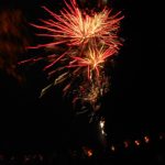 We will return to Long Point, planning additional time to secure your kayak on your car in the dark.
The Conesus Lake of Fire is an incredible local event in our area. If you have not experienced it, come join us for a fun, memorable time!
IMPORTANT UPDATE (posted Monday 7/17 ~12:40PM)!!! PLEASE NOTE RESCHEDULING OF THIS HIKE!!! – THE HIKE (ORIGINALLY SCHEDULED FOR MONDAY 7/17) HAS BEEN RESCHEDULED TO TUESDAY JULY 18TH (SAME TIME & PLACE). RESCHEDULING IS DUE TO WEATHER CONCERNS FOR MONDAY EVENING. ALL OTHER INFO REMAINS THE SAME.
FOR ANY POSSIBLE ADDITIONAL UPDATES – PLEASE CHECK THE FOGVG FACEBOOK PAGE.
**It should also be noted, subsequent to the hike, usually within a few days, often photos of the hike are posted on the FOGVG Facebook page.
An opportunity for a 7/17/2017 Monday hike, at Letchworth State Park, exists for ST hikers to join the members of Southern Tier Greenway Hiking group (STGH). STGH is made up of hikers who hike the southern section of the Genesee Valley Greenway State Park (GVGSP aka GVG) and many more locations. ST has hiked with some of these hikers during the Friends of Genesee Valley Greenway (FOGVG) annual event held in early November. And some STGH hikers have joined-in on some ST hikes. The information about this Letchworth hike is as follows.
Looking for brochure.or mailing list so I can receive it in the mail.
Nothing opens up for mailing list.
There’s all kinds of very bizarre ads and post for viagra and other drugs above on calender page.
Please let me know if there’s a brochure available