
Hikes led by Springwater Trails are generally held on Sunday afternoons and appear in this calendar in green.
| Sun | Mon | Tue | Wed | Thu | Fri | Sat |
|---|---|---|---|---|---|---|
| Lehigh Valley Trail Hike or Bike in Rush, NY 2:00 pm Lehigh Valley Trail Hike or Bike in Rush, NY @ Stevens-Connor Lehigh Valley Lodge Apr 6 @ 2:00 pm – 4:00 pm Come join us for a leisurely hike or bike along the Lehigh Valley Trail on Sunday April 6th! With its flat even surface, the trail is a hidden gem for walking, hiking, jogging, biking. It is a vital link in … Continue reading | ||||||
| Ontario County Park at Gannett Hill Hike-Naples 2:00 pm Ontario County Park at Gannett Hill Hike-Naples @ Lookout Parking area Apr 13 @ 2:00 pm – 4:00 pm  This is one of our group’s favorite hikes! Ontario County Park at Gannett Hill is one of the highest points in Ontario County and located in the scenic Bristol Hills. At an elevation of 2,256 feet above sea level, you’ll … Continue reading | ||||||
| No Hike-Easter Break 2:00 pm No Hike-Easter Break Apr 20 @ 2:00 pm – 4:00 pm No hike has been scheduled for this date due to the Easter Holiday. Enjoy the break, spend time with loved ones and eat chocolate bunnies. This will give you something to burn off next week  | ||||||
| Hike Rob’s Trail – Hemlock Lake side 2:00 pm Hike Rob’s Trail – Hemlock Lake side Apr 27 @ 2:00 pm – 4:00 pm Join us on Sunday April 27th to hike the west side of Rob’s Trail, the DEC/Nature Conservancy property in the northeast corner of Hemlock Lake! Options are to hike out and back to the south along the trail from the … Continue reading |
This Sundays hike will start with a short tour of the Wayland Historical Society on the corner of South Main St. and Washington St. in the village of Wayland. We will meet at 1:50 pm at the Wayland Historical Society parking lot.
After the tour, there will be a 1/2 mile hike out of the village and then on to a foot trail through a wooded area for a total distance of 3 miles. To practice social distance, we will return back to the Historical Society at which time, those that wish, can attend the “after hike social” at the “Belt In The Eye” restaurant on Main St. in Wayland.
Directions:
From Naples: Come into Wayland on Rt 21. Turn left at the red light and take the first right onto Washington St.The historical society will be on the left.
From Springwater: Come into Wayland on Rt 15 and continue through the red light. Take your first right onto Washington St. The historical society will be on your left.
From Dansville: Come into Wayland on Rt 63 and turn right at the first red light on to South Main St. Drive 500 ft and the historical society is on the left.
Welcome to the seventh Annual Mushroom Foray [thanks to both Springwater Trails and the Rochester Area Mycological Association] on Sunday, September 20, 2020, at the All Western Evergreen Farm. Three hiking groups are planned, all starting and ending at the parking area at the farm. We will explore much of the farm, enjoying views of the Christmas trees, forests, the valley and close-ups of the floral and mycological specimens.
Please plan to arrive early (1:45 PM) to sign in and to sign the RAMA liability forms.
Maps of the farm, paper bags and paper plates for collecting and displaying mushrooms will be provided. Those who want to learn how to collect mushrooms will be instructed by Gene and Georgia, and any other Rochester Area Mycological Association members who will be our guests.
The Climbers will follow the driveway up to the fields, and explore to the south and west, to explore the varied forests and Christmas tree plantations (Douglas-fir, Nordmann fir, Grand fir, Concolor fir, Canaan fir, Alaska yellow cedar, Norway Spruce, Meyer Spruce) for wild mushrooms up around the pond to Swartz Road and the Cathedral pines up to Story Road. Check out between the Christmas trees fenced off Story Road if you are looking for unusual mushrooms, back by way of the north field road, the giant Concolor fir in Scott Hill triangle and back through the Christmas trees (Fraser, Korean, and Concolor) that are fenced in UVW lots (the electricity will be turned off).
The Tourists will follow the driveway up through the woods, stopping occasionally to explore for mushrooms. When reaching saleable size Christmas trees (Lot Z), head to the right around or through the Christmas tree plantation. At the corner where the small Southwestern White Pine tree row ends and the tall Concolor fir are, follow the trail into the woods and back to the field and head west along the north field road to a hidden corner of the field with some spectacular 35 foot green and blue Concolor fir Christmas trees live, the size seen during Christmas season in a large mall. If there is still time, follow the north field road next to the hedge row up to Story Road along the tillable land that is rented or in the Conservation Reserve Program, along Story Road, the F Lot to the south field road and the Cathedral pines and back to the house through the woods.
The Naturalists will start exploring under and behind the Western red cedars (thuja plicata or giant arborvitae) by the parking area and south to the Alaska yellow cedar, large Concolor fir and spruce, then back up through the woods to the right of the trail up to the main fields. These are likely full of mushrooms, but you will find some swampy areas, so don’t get lost behind people’s homes along Liberty Pole.
All hikers should check their watches and return to the parking area by 4:00 PM to have their collections identified. A portapotty with a sink is nearby.
Mushroom Identification
Once again we are fortunate to have several RAMA members (Randy Weidner, Don Tuminelli, Eugene & Georgia Binder) with us who have volunteered to identify the mushrooms collected between 4 and 5 PM. After the mushrooms are identified please join us for a social (5:00 – 6:30 PM) hosted by Katherine outside the house next to the Furnace Building. She has offered to make Take-out Soup to be available in individual covered containers by donation. Please bring a lawn chair and your own bag lunch and beverage.
We will begin all the hikes at 6840 Liberty Pole Road where there is ample parking at the Christmas tree loading area between the tall Western redcedar and Morton Building and Nursery beds. Follow the parking signs. When we return from our foray, the mushrooms will be displayed for identification on paper plates on the tables outdoors. Please dress for the weather, rain gear as needed. Social distancing and masks are recommended when close together.
From Springwater: Go west from the Springwater light on NY-15 North. Just past the top of the hill and after rounding the tight curve, turn left on CR 38 (Liberty Pole Road). The farm is on the left (the high side) 1.1 miles from NY-15 at 6840 Liberty Pole Road after you cross Carney Hollow Rd. There is a sign for the All Western Evergreen Nursery & Christmas Tree Farm. Follow the orange cones to the parking area and park facing the house.
From Geneseo: Go south on NY-63. About 6.4 miles after passing NY-408, turn left on CR-1 (Groveland Scottsburg Rd) at Groveland Station. This road becomes CR 1A (Springwater Scottsburg Rd) at Scottsburg (Route 256) and then Liberty Pole Road after you cross Stagecoach Road (CR 71), and finally CR-38 (still Liberty Pole Rd) after crossing Reeds Corners Rd (CR-29). It is 7.1 miles from Groveland Station to All Western Evergreen Farm. The farm is on the right (the high side). Follow the orange cones to the parking area and park facing the house.
From Honeoye: Take 20A west to Hemlock and 15A south to Springwater. Then follow the Springwater directions above.
From Rochester: Take I-390S from Rochester. Use Exit 9 for NY-15 Lakeville. Turn left onto NY-15. Stay on NY-15 for 16.5 miles, through Lakeville, Livonia, Conesus and Webster Crossing. When NY-15 curves to the left at the south end of Webster Crossing, continue straight onto CR-60 (Carney Hollow Rd) and take the first right onto Liberty Pole Rd. The farm is on the left (the high side) at 6840 Liberty Pole Rd. Follow the orange cones to the parking area and park facing the house.
If using GPS, use the map directions on the www.allwesterntrees.com website and make sure you are on Liberty Pole Road and not being directed to the center of the farm from Swartz Road or Story Road. Follow the orange cones to the parking area and park facing the house.
This Sunday’s event will explore the large marshland at the south end of Canandaigua Lake. There will be two options – boaters will commence at the State Boat Launch in Woodville, NY , 4 miles north of Naples; hikers will start at the trail crossing on Parish Rd.
Boaters will meet at the state Board Launch in Woodville. Please plan to arrive in time to have your boat launched by 2:00. We will be paddling across the south west corner of Canandaigua Lake into the inlet of the West River, a lazy winding stream which traverses a large marshland. The wetlands are gorgeous in the Fall, with autumn colors and abundant waterfowl. The plan is to travel up stream as far as conditions allow. There are a couple of different channels to explore. Due to the dry summer we have had. the water level will be low in places, with accumulations of weeds and algae. Hopefully we can get in 2 hours on the water.
Hikers will meet at the parking area on Parish Rd where the trail crosses the road.They will hike the Middlesex Valley Rail Trail across the marsh toward Sunnyside Rd. This will be an out and back hike, so plan to walk for an hour and then return to the cars. If the group wishes to split into two groups, one group could head west on the trail, turning around at the missing bridge near Rt 21, and then returning to the cars and walking beyond based on the time.
NOTE: Should the weather conditions be unfavorable for boating (i.e. too windy for safety), there will be the option to hike instead, at Ontario County Park, a short drive away. The decision will be made at the boat launch by the trip leader. Please bring your hiking boots if you are interested in this alternative.
In the event of rain, the event will be cancelled by 12:00 noon. When in doubt check the website.
Social Gathering will be at the small village park in Naples, adjacent to Bob and Ruth’s Restaurant which is located at 204 N Main Street (Rt 21). Please bring your own meal and beverage or order take out from Bob and Ruth’s 374-5122. There are some picnic tables, but for social distancing it is best to bring your own chair.
Directions The hike trail parking is on the east side of Parrish Rd. From Wayland and Naples take NY-21 North to Naples. Bob & Ruth’s is on the left side as you head out of the village, across from NY 245. Continue for 1.7 miles on NY 21 past Bob & Ruth’s. Turn right on Parish Rd. In 0.4 miles you will see the trail crossing the road. Turn left onto the trail and park in the lot available for hikers. From the north, take NY 21 from Canandaigua or NY 64 down Bristol valley. In South Bristol, continue south on NY 21 for 4.5 miles past the intersection of NY 21 and NY 64. Turn left on Parish Rd. In 0.4 miles you will see the trail crossing the road. Turn left onto the trail and park in the lot available for hikers.
The Kayak and Canoe launch site is on Rte 21, 3.4 miles north of Bob & Ruth’s restaurant in Naples. From Wayland and Naples head north on NY-21. Continue past Bob & Ruth’s for 3.4 miles on NY 21. Just Turn right into the paved boat launch parking area. From the north, take NY 21 from Canandaigua or NY 64 down Bristol valley. In South Bristol, continue south on NY 21 for 2.8 miles past the intersection of NY 21 and NY 64. The boat launch is on the left.
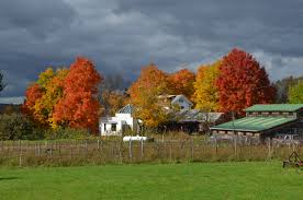
This Sunday we will return to the Schribner Valley to explore the fields and forests of the valley. We are looking forward to the beauty of the Fall season, from late wild flowers to the forest colors. We will be looking for closeup and panoramic opportunities.
We have planned two hikes. The Climbers will head up to the top of the hill and will follow the top of the woods along the valley, enjoying the fall colors both up close and in the distance. The Tourists and Naturalists skip the steeper part of the hill, exploring the fields and creeks closer to the house.
Following the hikes, please join us for a social around the bonfire. Bring your own sandwich and beverage. We will provide the ingredients for s’mores. Depending on the weather, we may have some kayak races on the pond!
Directions: Our home is at the intersection of Giles Rd and Schribner Rd, one mile north west on Schribner off of Tabor’s Corners Rd in Springwater. Detailed directions are available here.
This Sunday people will have the choice of biking the Keuka Lake Outlet Trail or hiking a section of it. The trail follows Keuka Lake’s outlet to Seneca Lake; the outlet stream starts in Penn Yan and goes 7.5 miles to Dresden dropping 275′ along the way. We will be going the other way, starting in Dresden.
This trail is in a pretty wooded ravine. It was “formerly a canal towpath and later a rail road bed, it crosses the original Pre-Emption Line and passes near the area of the first permanent white settlement of ‘The Universal Friend Jemima Wilkinson’, along waterfalls and ruins of mills, factories and canal locks”. The web site for the Outlet Trail is http://keukaoutlettrail.org
The Hike Assembly Point:
Both bikers and hikers will meet at the Dresden end of the Keuka Outlet Trail on Elm Street in Dresden (map coordinates 42.681388, -76.958498).
For Cyclists:
Bikers will go out and back on the Outlet trail approximately 14 miles. Because the trail is a combination of dirt, gravel and asphalt and somewhat uneven, hybrid bikes or bikes with fatter tires are best suited for this trail.
For Hikers:
The Climbers will follow the trail to Milo Mill, approximately 2.4 miles along the trail, and then walk back to the assembly point. Tourists and Naturalists will drive back along the trail to the Seneca Mill parking lot, and then they will walk along the trail towards Pen Yann for an hour, and then walk back to Seneca Mill.
The Social:
After the hike we will gather at the Seneca Mill picnic area, above the mill pond and have a BYO picnic.
Directions:
From Springwater, Wayland and Naples: Head south from Springwater on NY-15S to Wayland, then turn left on NY-21. Follow NY-21 for 12.7 miles through N Cohocton and Naples. Turn right on NY 245N across from Bob & Ruth’s. Follow NY-245 for 8.9 miles to Middlesex and take a slight right turn onto NY 364E. In Penn Yan, continue straight on to Rt. 54 west to Dresden. At the end of Rt. 54, cross Rt. 14 and then take the first right on Senaca St. The trail head is 100 yards or so ahead at the railway crossing.
From Honeoye: Take W Lake Rd (CR 36) south to Main St in Naples. Turn left on NY 21 (Main St) for 1.2 miles. Turn right on NY 245N across from Bob & Ruth’s. Follow NY-245 for 8.9 miles to Middlesex and take a slight right turn onto NY 364E. In Penn Yan, continue straight on to Rt. 54 west to Dresden. At the end of Rt. 54, cross Rt. 14 and then take the first right on Senaca St. The trail head is 100 yards or so ahead at the railway crossing.
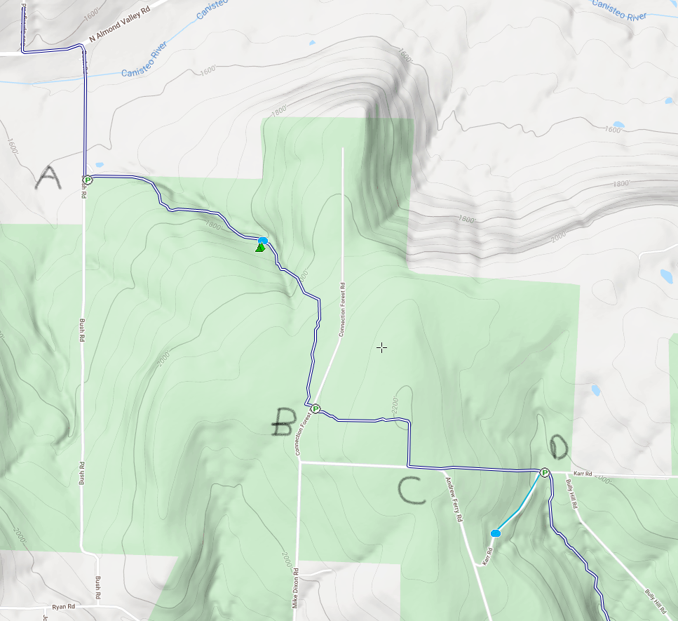
All hikers will start at Access Pt 4 (A) and hike eastward. Based on time, groups will turn around at the three road crossings B, C or D.
Welcome back to the Finger Lakes Trail. This Sunday we will return to the Bully Hill State Forest for a hike on the main Finger Lakes Trail to enjoy another fall hike before the regular hunting season starts.
Note: Bow season is open, so an orange vest and hat are recommended.
All hikers will meet at Access 4 on Bush Rd. Shoulder parking is available here, just before the seasonal road starts. We will split into three groups based on the desired distance and will do an out and back hike. On the way back, we will stop at the Bully Hill lean-to for a picnic social (if weather permits). The lean-to is about 3/4 mile from the cars.
This hike is primarily uphill going out, with a total elevation change of 600 feet. The lean-to overlooks a gully that we will cross. In the spring the trail was quite wet, but drier conditions are expected this weekend.
The Naturalists will hike to the first road crossing (B). They will turn around at that point and return to the lean-to for a social for a 2 mile hike (plus 0.7 miles after the picnic).
The Tourists will continue on to the second road. For some variety, they will then turn right on the road, and do a forest road walk back to the trail at B and the turn left to follow the trail back to the lean-to. This will be a 3.6 mile hike out and back to the cars.
Finally, the Climbers will follow the trail all of the way to Kerr Rd (D). This will be a 4.4 mile hike out and back to the cars. All hikers should keep track of the time to meet at the lean-to by 4:00.
Directions:
Since many hikers have never been to Bush Rd in Almond, NY, we will offer a caravan option from the parking lot behind the Firehall in Wayland. Plan to meet at the parking lot at 1:05. We will leave promptly at 1:15. Because of COVID, we are not encouraging carpooling, but we can follow one another.
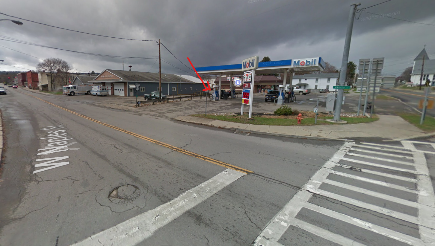 Meeting location in Wayland: From the intersection of NY 15, NY 21 and NY 63 in Wayland, head west on NY 63. At the Firehall, turn right the gas station and the Firehall to the public parking lot behind the firehall. From N Main St, you can enter the parking lot along the north side of the Belt in the Eye Diner.
From Wayland to the trailhead: Head south on NY 15. Turn right onto I-390, and take the next exit at NY-36 Dansville. Turn right onto NY-36 for 11.5 miles to Arkport, NY. At the light in Arkport, turn right onto West Ave. Just past the railroad and the building on the left, turn left onto CR 67 (Bishopville Rd). In 7 miles, turn left onto Bush Rd, a small dirt road. It is less than half a mile up to the last house at the “Seasonal Rd” sign. The trail enters the woods on the left (east) side of the road.
From Geneseo and Rochester: Take I-390 S to Exit 4 (NY 36 Dansville and Hornell). Turn right onto NY-36 for 11.1 miles to Arkport, NY. At the light in Arkport, turn right onto West Ave. Just past the railroad and the building on the left, turn left onto CR 67 (Bishopville Rd). In 7 miles, turn left onto Bush Rd, a small dirt road. It is less than half a mile up to the last house at the “Seasonal Rd” sign. The trail enters the woods on the left (east) side of the road.
Rochester Folk Art Guild – Golden Valley Hike
Sunday October 25 we will visit East Hill Farm, home of the Rochester Folk Art Guild, for a hike across their 350-acre hilltop farm and woodlot. The Guild is a community of craftspeople, producing fine quality handmade products in wood, pottery, fabrics, paper, toys, books and more. We will have an opportunity to visit their Gallery Shop for holiday shopping at the end of the hike – for more information about the 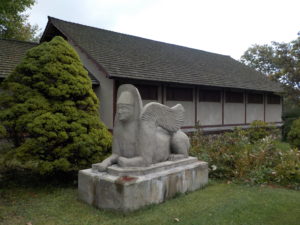 Guild see:
https://www.folkartguild.org/about-us/ .
Please arrive by 1:45 for hiking at 2 PM. Park on the road shoulder at 1445 Upper Hill Road, Middlesex (directions below). We will convene at the side of the East Hill Gallery, the first building on the left as you come in the driveway.
Climbers will head south through the Guild’s farm and neighboring properties, past a pond and sauna, through a spruce grove, and looping through woods and mowed fields to the Golden Valley, named for its spectacular fall color and views to the east across Italy Valley. We will return through the woods and pass an eclectic array of residential buildings, workplaces and gathering places, designed and built by community members over their 50 years of occupancy at the East Hill Farm. Total distance is about 3.5 miles. Tourists and Naturalists may shorten the hike by retracing their steps at any point. Trails are gently sloped and well cleared. As a hunting season precaution, please bring some bright colored outerwear, along with water, poles and dampproof boots.
Social: We will convene after the hike for a bring-your-own social on the grounds of the Guild’s main farmhouse.
Directions: from Springwater/Naples: Take Route 15 south to Wayland and Route 21 east/north to Naples. Turn right on Route 245 opposite Bob’s and Ruth’s Restaurant, at the north end of the village. Follow Route 245 north to Middlesex, about 8.75 miles. Turn right on Route 364 and go up the hill, one mile. Turn right on Upper Hill Road and go 1.5 miles. East Hill Farm will be on your left, at #1445. Park on the road shoulder and walk in the driveway to the Gallery building, the white house on your left.
From Rochester and points north: Head to Routes 5 and 20 via Bloomfield or Canandaigua. At the east edge of the City of Canandaigua (first light after Wegmans/Post Office), turn south on Route NYS Route 364 (a.k.a. East Lake Road). Follow Route 364 south 12.5 miles to Middlesex, where 364 turns to the east and you will make a left onto Route 245 and then an immediate right to continue on 364. Go up the hill, one mile. Turn right on Upper Hill Road and go 1.5 miles. East Hill Farm will be on your left, at #1445. Park on the road shoulder and walk in the driveway to the Gallery building, the white house on your left.
NOTE: This is the first day of Standard Time. Please set back you clock or you will be an hour early for the hike!
This Sunday we will hike the Finger Lakes Trail (FLT) starting at the Mt. Morris Dam and Visitors Center Parking Lot, as well as the Wildlife Loop Trail within the Dam property. We expect to enjoy the remainder of the fall colors and, as we follow the east rim of the Letchworth gorge, the spectacular views of the gorge and Genesee River below.
The Wildlife Loop trail within the dam property is beautiful in its own right, with forest and grassy fields.
Two levels of hiking are planned – “Climbers” and “Tourist/Naturalists” will both hike south on the yellow blazed (FLT) trail along the rim of the gorge, jogging east slightly away from the river across a boardwalk through a small wet area, stop at Hogsback Overlook to view the Hogsback formation of the river gorge, continue on the trail another .2 miles before turning around to head back. On the way back, we will follow the same yellow blazes but take the alternate orange blazed trail along the rim of the gorge which joins back up with the yellow trail, back to the parking lot. Total hike is 2.25 miles.
Once back to the parking lot, the “Climbers” who want a longer hike will follow the blue blazed Wildlife Loop Trail which begins just to the right of the Mt. Morris Dam Visitors Center, adding another 1.1 miles to the hike.
The Hike Assembly Point:
The Visitors Center will be closed. However, there is a bathroom adjacent to the parking lot that may be open on the day of the hike. All hikers will begin the hike at the Mt. Morris Dam Visitor Center Parking Lot. The trail access is at the west end of the parking lot (to your left as you face the gorge). While this trail is in a non-hunting area, it is recommended that you wear brightly colored clothing.
Social:
After the hike, all are welcome to gather at the larger pavilion located adjacent to the parking lot. Bring your own snack, drink, and chair (due to limited seating and need for social distancing).
Directions:
The Mt Morris Dam Visitor Center is about 45 minutes from Springwater, so please plan ahead. If you have a GPS, try entering Mt Morris Dam as your destination. Or enter Park Rd or Visitor Center Rd, Mt Morris.
From Springwater: Take Rt 15N and then left on Liberty Pole Rd. Stay on that road all the way to Rt63. There, take a left, and a quick right, onto Rt 258. At Rt 36, take a right and proceed to Mt. Morris. Turn left onto NY-408 South.
From Wayland: you can take I-390 north to exit 7. Turn left at the exit on NY-408 S to Mt. Morris. NY-408 goes left at Main St, then right on Chapel St.
From Hemlock and Honeoye: follow 20A West through Livonia and Lakeville to 390S. Exit at exit 7 NY 408 S to Mt Morris. Stay on 408 through Mt Morris.
From Rochester: Take I-390S to Exit 7 NY 408S. Stay on Rt 408 through Mt Morris.
From NY 408 in Mt Morris: Go south on 408 for 1.8 miles to Visitor Center Rd. Turn right at the Visitor Center Road and follow the road all the way to the Dam and Visitor Center Parking lot.
Please join us this warm and sunny fall Sunday to explore a new hiking site not far from Springwater. A few years ago New York State acquired several new parcels of land to the south of Harriet Hollister Spencer Park, linked to the main park by an established snowmobile trail called C4. Last August we hiked the section of the C4 trail closest to the main park, and this Sunday we will explore the rest of the C4 trail, going as far as Dutch Hollow Road and back. The hike will take us across a field with fine views toward Springwater and beyond, and through some little-traveled woods.
Meet at 1:45 PM at the intersection of Canadice Hill Road and Tibbals Road, a.k.a Townline Road (that’s the town line between Canadice and Springwater – also the Ontario-Livingston County Line). Park on the road shoulder. Total distance for Climbers is about 4 miles round trip. Tourists and Naturalists will follow the same route, but turn around after 45 minutes for a total hike of 1.5 hours and about 2.5 miles.
Wear something orange or otherwise conspicuous in case of bow hunters. As always, bring water, good hiking footwear and poles if you typically use them. The trail is gently rolling – no especially steep sections.
Social: After the hike we will repair to Birdhouse Brewing Company at 8716 Main Street, Honeoye. Sunday afternoon promises to be warm enough for us to be seated on the deck or in the tent. See https://birdhousebrewing.beer/index.php/about/ for their menu of craft beers and food.
Directions:
From Springwater and Wayland – take Route 15A North from Springwater, turning right on Wheaton Hill Road. Take a left on Canadice Road (County Road 42), forking to the right when County Road 42 divides off from Canadice Lake Road. Make the next right, on Tibbals Road (formerly Town Line Road). The trail head is where Tibbals Road ends at Canadice Hill Road/Wetmore Road.
From Rochester or Canandaigua – go to Honeoye, and follow Route 21A (Main St. Honeoye) west toward Hemlock. About a mile out of Honeoye turn left on County Road 37. Follow County Road 37 until it makes a 90 degrees turn to the right across from the Canadice Methodist Church; at this point go straight onto Canadice Hill Road instead of County Road 37. Continue straight on Canadice Hill Road, taking the left fork at Ross Road, and passing the main entrance to HH Spencer Park. The trail head is 1.7 miles south of the main park entrance, and 8.5 miles from Route 21A. Beyond the trailhead Canadice Hill Road turns into Wetmore Road.
Directions from Hike to Social at Birdhouse Brewing Co.
-
Take Canadice Hill Rd. going toward Harriet Hollister Parking Lot. Keep going straight, it will become County Rd. 37.
-
When you come to Route 20A you will make a right. (at the intersection, St. Mary’s Catholic Church will be on the Right corner). Take 20A into Honeoye.
-
Birdhouse Brewing will be a brown building on your left, four buildings past the traffic light.
On Sundays they serve Hot Dogs and Hamburgers and are open until 7:00pm.
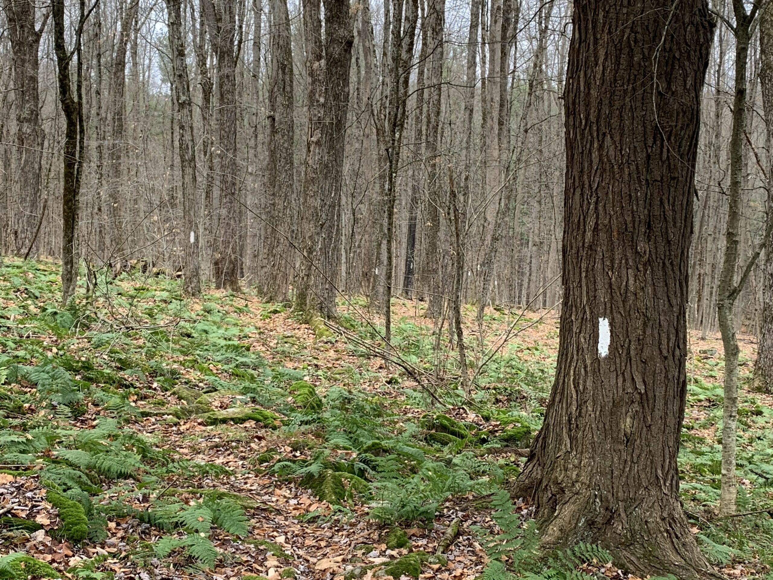
The trail is well blazed, but otherwise hard to distinguish from the rest of the forest.
Last month we hiked the Finger Lakes Trail in Bully Hill State Forest on a blanket of newly fallen fall foliage and enjoyed the beautiful colors. This month we are moving north to the Klipnocky State Forest, but all the leaves have lost their colors. Yet, the forest is still interesting and it is fun to be able to see through the trees to the ridges across the valley..
Note: Bow season is open, so an orange vest and hat are recommended.
Our hike will be an out and back, partly to avoid car pooling during COVID and partly because the roads inside the state forest aren’t great on you car. All hikers will meet at the end of Klipnocky Rd where it connects to Bill Morris Rd and Roots Rd. These roads inside the state forest are seasonal and not real good. Good clearance on your car is recommended.We should be able to park along Bill Morris Rd.

FLT Register at the stream crossing.
We will head west on Roots Rd to where the trail enters the forest on the left side of the road. The trail goes down to a creek and a register. The trail then has a slow climb along a well blazed trail to a dirt road. At this point the Naturalists can turn right and follow the road back to the cars. The Climbers will continue across the road for 3/4 of a mile where the trail starts down the remnants of an old road that becomes Gas Springs Rd in a half mile. This is a good spot to turn around because the old road is quite rough for walking. When we get back to the real road, the Climbers can either turn right and follow the road to the cars, or continue straight across the way they came.
Following our hike, we will have a simple social by the pond at our parking area. Please bring a sandwich or snack, and a beverage for you and your family. Also, bring a chair if you would like to rest!
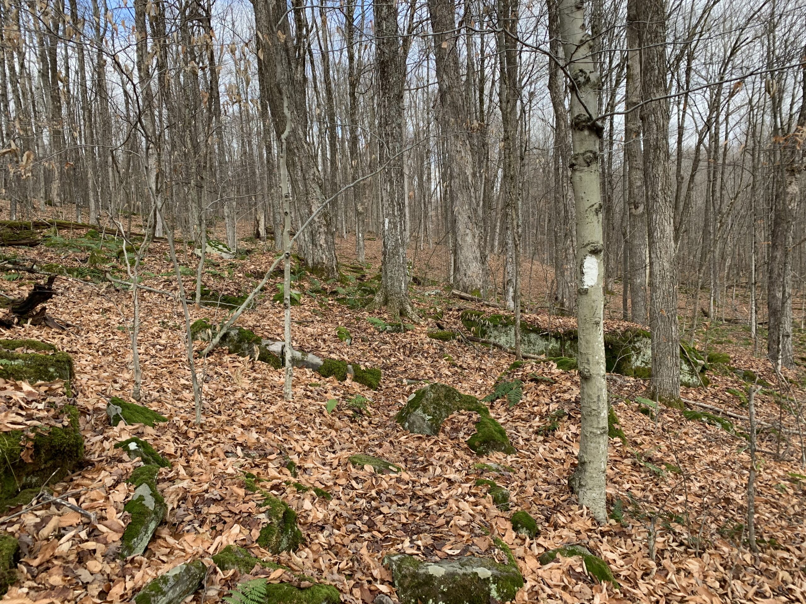
How many blazes can you see?
Please note that this trail is rocky, so you will find yourself watching your feet most of the time. Stop occasionally to look around and see the forest. Also, watch the blazes to stay on the trail.
Directions:
Since many hikers have never been to Klipnocky State Forest in Almond, NY, we will offer a caravan option from the parking lot behind the Firehall in Wayland. Plan to meet at the parking lot at 1:00. We will leave promptly at 1:10. Because of COVID, we are not encouraging carpooling, but we can follow one another.
 Meeting location in Wayland: From the intersection of NY 15, NY 21 and NY 63 in Wayland, head west on NY 63. At the Firehall, turn right the gas station and the Firehall to the public parking lot behind the firehall. From N Main St, you can enter the parking lot along the north side of the Belt in the Eye Diner.
From Wayland and Dansville: Head west on NY 63 from Wayland to Dansville. Turn left onto Clara Barton St (NY-36S). Continue on NY-36 for 7 miles to the light in Arkport. Turn right on West Ave. after the railroad tracks, turn left on CR 67 (Bishopville Rd), which becomes CR 32 in Allegany Co. In 2.9 miles from Arkport, Bishopville Rd will turn left, but you should continue straight on CR 32. In another 1.8 miles, turn right on Brown Rd. At the end turn left on Klipnocky Rd. At the tee, turn right. Park near the next intersection,
Looking for brochure.or mailing list so I can receive it in the mail.
Nothing opens up for mailing list.
There’s all kinds of very bizarre ads and post for viagra and other drugs above on calender page.
Please let me know if there’s a brochure available