
Hikes led by Springwater Trails are generally held on Sunday afternoons and appear in this calendar in green.
| Sun | Mon | Tue | Wed | Thu | Fri | Sat |
|---|---|---|---|---|---|---|
| Lehigh Valley Trail Hike or Bike in Rush, NY 2:00 pm Lehigh Valley Trail Hike or Bike in Rush, NY @ Stevens-Connor Lehigh Valley Lodge Apr 6 @ 2:00 pm – 4:00 pm Come join us for a leisurely hike or bike along the Lehigh Valley Trail on Sunday April 6th! With its flat even surface, the trail is a hidden gem for walking, hiking, jogging, biking. It is a vital link in … Continue reading | ||||||
| Ontario County Park at Gannett Hill Hike-Naples 2:00 pm Ontario County Park at Gannett Hill Hike-Naples Apr 13 @ 2:00 pm – 4:00 pm  Save the date! This is one of our group favorite hikes. Ontario County Park at Gannett Hill is one of the highest points in Ontario County and located in the scenic Bristol Hills. At an elevation of 2,256 feet above … Continue reading | ||||||
| No Hike-Easter Break 2:00 pm No Hike-Easter Break Apr 20 @ 2:00 pm – 4:00 pm No hike has been scheduled for this date due to the Easter Holiday. Enjoy the break, spend time with loved ones and eat chocolate bunnies. This will give you something to burn off next week  | ||||||
| Mystery Hike-Details Coming Soon 2:00 pm Mystery Hike-Details Coming Soon Apr 27 @ 2:00 pm – 4:00 pm Mystery Hike coming your way….details under construction. Please check back. |
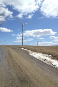 Come walk among the Dutch Hill Wind Farm, part of the 125-Megawatt wind farm located in Cohocton NY, on Sunday, July 29, 2018 at 4pm. We will meet at our ending point just off Shults Hill Rd in the Town of Cohocton and car pool to our starting point. Location is first road on the right past the Lawrence Parks Recreation area 10726 Atlanta Back Road in the Town of Cohocton. This will be a 3.6-mile hike on rolling dry gravel roads among the farm fields. Milkweed is in bloom so butterflies aplenty along with the hawks soaring above. If the climbers want a longer hike we will drop them off on a .6 mile, uphill, through the woods, on a seasonal road for them to walk to the starting point.
Following the hike, join us for a social at the Mt. View Inn 34 Main Street Atlanta. NY.
Directions: Use Lawrence Park address above
Or
From Springwater and Wayland: Head out on Rte. 15 South to Wayland. At the light turn left onto Route 21 North. Go 5.9 miles turn right on to Beecher Street. At the 4 corners of Beecher St, West Ave, North and South Main Streets in Atlanta turn left. Go past the Mt View Inn and take your first right on to Erie Street which turns into Atlanta Back Road. Go 2.3 miles to Shults Hill Road. You will pass the Lawrence Park recreation on your left. Watch for parking either across the road in the field or on Shults Road itself. Depends on hay season.
From Rochester: Take 390 South to the Wayland Exit. Turn right off the exit and travel 1.8 miles to the light in Wayland. Turn right onto 21 North and follow directions above.
From Honeoye: Follow W Hollow Rd (County Road 36) to Naples. Turn Right at the Middletown Tavern on to Rte. 21 South, for 5.4 miles turn left onto Beecher Street. Follow directions above. Social will be at the Mt. View Inn 34 Main Street Atlanta. NY.
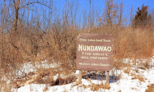
Sunday’s hike takes us to the Seneca nation’s Great Hill at the southeast corner of Canandaigua Lake.
 We will meet at 3:45 PM at the NYS DEC parking lot at the juncture of West Avenue and Sunnyside Road, in the Town of Italy and at the south end of the Middlesex Valley. There will be no formal groups – Tourists and Climbers may turn around and return to the start when they see fit. At Clark Gully, which is easy walking distance from the DEC parking lot, we will view the emergence spot of the Onundawaga (Seneca) from a previous world to this one (in distinction to the story of Sky Woman, who fell). Their name means People of the Great Hill, and this is it.
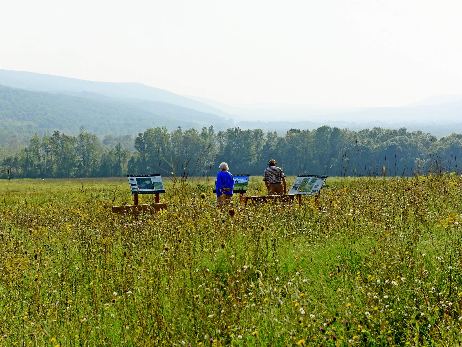
 After that short walk we will adjourn to the West River Nature Preserve, a Finger Lakes Land Trust property right across Sunnyside Road to look at signs and explanations of the 32 acre property which is prime grassland bird habitat now (previously was abandoned vineyard). Then we will walk on Sunnyside Road south and west toward Canandaigua Lake until we come to the Great Hill Nature Preserve (also FLLT) about 1 mile up and to the left (sign), and we will turn into it and walk a trail about 1.5 miles to its end, then turn and come back to our cars. All in all, about 3.5 miles. What with gawking it should take us about 2 hours.
Social gathering is at the Middletown Tavern, 183 S. Main St., Naples.
Directions:
From Springwater and points south, west and northwest: Go to Naples, then turn onto Route 245 opposite Bob’s and Ruth’s. After 4 miles, turn left on Sunnyside Road. The parking area is on your right, in about .4 miles.
From Rushville, and points north and east: From Rushville, take Route 245 South 9.75 miles through Middlesex and on to the Sunnyside intersection. Make a right, go .4 miles to the parking area on your right.
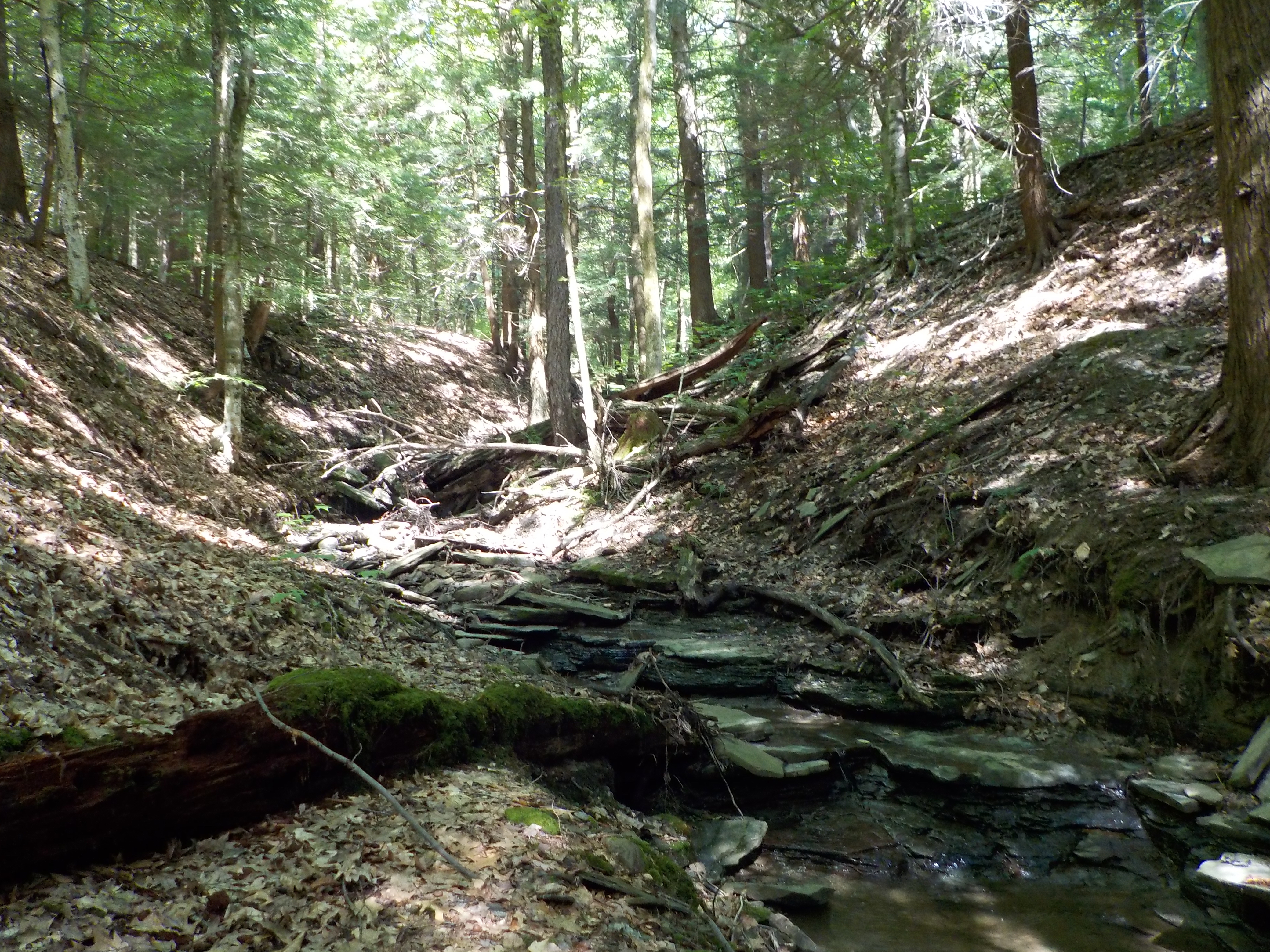
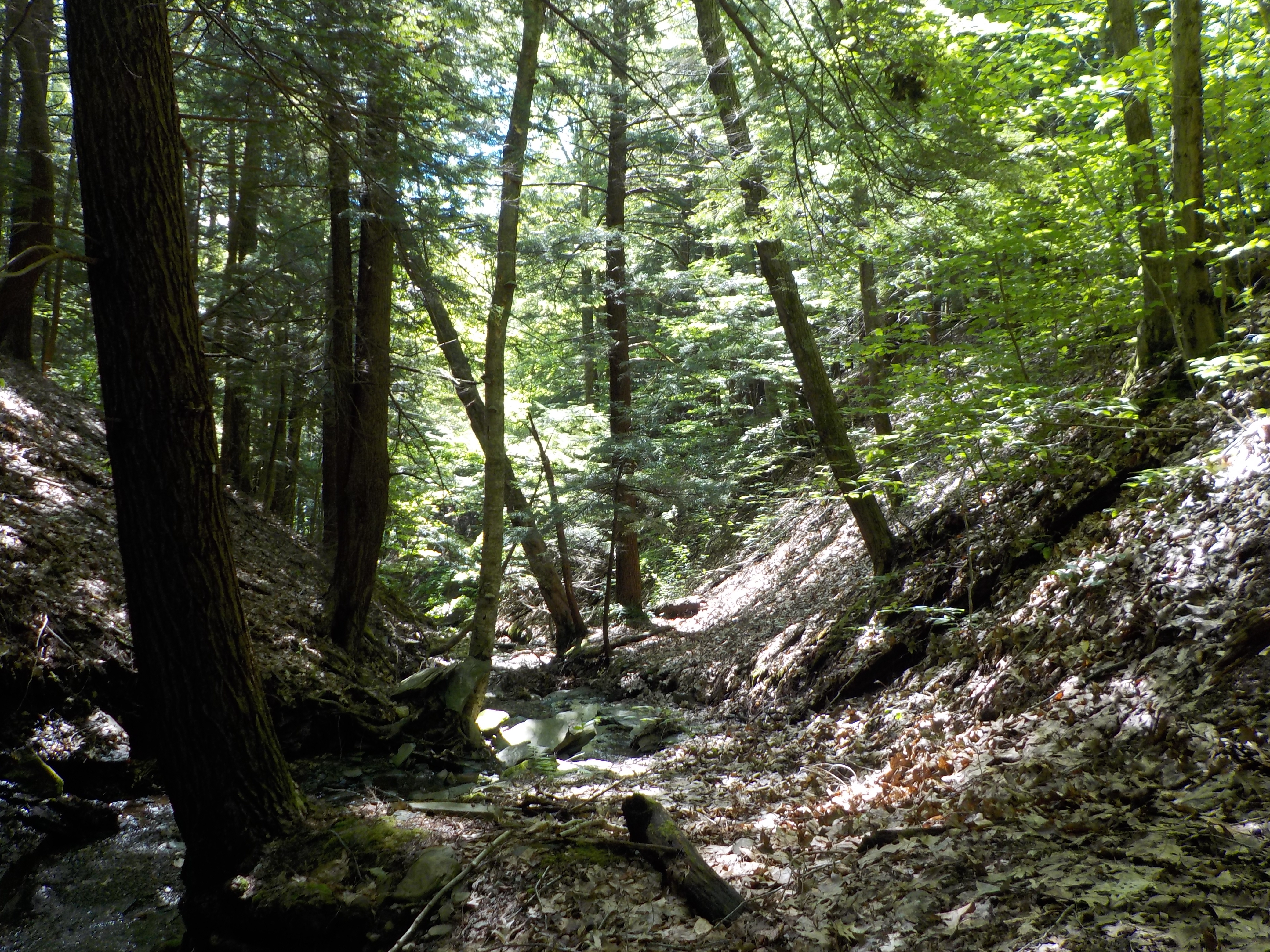 This Sunday we’ll have a chance to see the Wesley Hill Preserve from a different angle with the option of an off-trail walk down a hemlock-lined stream bed.
We will meet at 3:45 at the parking lot on Gulick Road, north of Cummings Nature Center and south of Wesley Road. Both Climbers and Tourists will follow the Red Trail past the pond to the spot where it crosses a side stream (not the much deeper Briggs Gully). Hikers comfortable with the rough terrain of the stream bed will head down the stream about .8 miles, to the point where the Red Trail again crosses the stream, near the Wenrich Cabin (about an hour of streambed hiking), and then return on the Red Trail, with a detour on the Green Trail down into Briggs Gully for those wanting more of a climb. The stream gradient is gentle, and it’s likely to have a moderate amount of water in some sections and be dry in others. There are occasional fallen trees to negotiate over or under. Caution and flexibility are required. The level of difficulty is similar to what we saw last week in Clark’s Gully. Wear footwear with good traction that you don’t mind getting wet, and poles are recommended.
 For those looking to stay on a trail, the Climber group will follow the Orange and Red Trails for a total of 4 miles. The Naturalists will hike to the pond and into the relatively level woods beyond on the Red Trail, retracing their steps when they choose.
Wesley Hill is a Finger Lakes Land Trust property of 390 acres on the hill east of Honeoye Lake. including stands of northern hardwoods, red and white pines, a woodland pond, and the northern edge of Briggs Gully, as well as the Wenrich Cabin, set in an old forest overlooking the gully, deep in the woods. A network of trails through the preserve offers excellent hiking routes of various lengths and levels of difficulty. The preserve was established in 1999 by the generous donation of 90 acres by the children of three artists – John Wenrich, James Havens and Colburn Dugan – to the Finger Lakes Land Trust. Since that time, the Land Trust has expanded Wesley Hill through the purchase or donation of four additional parcels.
 Following the hike, the optional social will be at the Boat House Grill behind Trident Marina, 5226 East Lake Rd, Honeoye, NY.
From Honeoye: take route 20A east through Honeoye to East Lake Road (CR 33). Turn right onto East Lake Road. (If coming from Bristol or points east, its a left onto East Lake Road). Take the first left, staying on CR 33, then the first right onto Pinewood Hill which becomes Gulick Road. Travel about 5 miles to Wesley Hill Parking Area on the right side. Parking lot can fit about 10 vehicles; the rest of us can park on the side of the road (it’s paved).
From Springwater: Head north on Rte. 15A toward Hemlock. Just before Hemlock, turn right on Rte. 20A. Follow Rt 20A to Honeoye and then follow the directions above.
From Naples: From the southern end of Naples, head west on Co Rd 36. Follow Co Rd 36 for 1.2 to the first right turn on Gulick Rd. Follow Gulick for about 7 miles. The parking area is on the left.
Directions to the Social from the trailhead:
Via the seasonal part of Wesley Rd.: Turn left out of the parking area and head north on Gulick Road. Turn left on Wesley Road, the first left. At the bottom, turn right on East Lake Rd. The marina is on the left in 3.1 miles. The Boat House Grill is in the back of the building with a view of the lake.
Via Gulick Rd: Turn left out of the parking area on Gulick Road. In about 3 miles, the road bears left and becomes Pinewood Hill Rd. At the stop sign, turn left to stay on Pinewood Hill Rd (CR 33). In 0.4 mi, turn left onto E Lake Rd. In 0.8 miles, turn right at the sign for Trident Marine. The Honeoye Boat House Grill is about 150 feet down on the back of the building with a view of the lake.
 This week, Springwater Trails is starting a series of monthly hikes along the Letchworth Branch of the Finger Lakes Trail. This 25 mile long trail passes along the top of the Letchworth Gorge on the eastern side of the park. The trail is known for beautiful views of the gorge for a vantage point that is often unfamiliar to regular visitors to the Letchworth Park. In addition to the main gorge and the Genesee River, there are many small streams that cross the park from east to west, carving gullies that must be crossed by hikers. So, we will often experience detours from the edge of the Gorge where these gullies are steep and deep, eastward to the head of the gully where crossings are possible.
Our hike this Sunday will begin on the Greenway in Mt Morris. The Climbers will hike through the Al Lorenz County Park, past the Mt Morris Dam to Access C, a total of about 3.5 miles. The first half of the hike will be up a fairly steep hill to reach the flat area at the top of the gorge. The Tourist group will do the same hike in reverse – trading the steep climb for a steep descent. The Naturalists hike will be primarily flat. They will start at the Dam parking area and head north to the Wildlife Loop for a 1.5 mile hike. After returning to the parking area, the Naturalists may want to head south on the Letchworth Branch trail to enjoy some views of the gorge.
All hikers will meet at the parking area 400 feet north west of State St on Main St in Mt. Morris. Please come early to help arrange car pooling to Access Pt C at the south end of this week’s hike.
The Tourists will drive to Access Pt C (Hogsback overlook) to start their hike. After parking, they will immediately enjoy a view of the Letchworth Gorge. Turning to the right, they will follow the Letchworth Branch blazed yellow for about a mile to the Mt. Morris Dam Visitor Center parking lot. Yellow blazed are painted on the lamp posts down the center of the parking area, Continue across the parking area to the right corner of the visitor center where you will find a mowed trail heading diagonally across the field. On the far side of the field, continue to follow the yellow blazes. When you join the Wildlife loop, stay to the left to follow the yellow and blue blazes. The yellow blazes will leave the Wildlife loop to the left to start the descent along the gorge. After passing an old log cabin, you will see the pavilions of Al Lorenz County Park. Take the lane to the left up the hill to the Livingston County campus. Turn left on Sickles Rd and walk the road down around several switchbacks. At the bottom, the yellow blazes end at the Genesee Valley Greenway. Turn right on the Greenway and follow the trail beside the old Genesee Valley Canal to Main St and the awaiting cars.
The Naturalists will car pool to the Mt Morris Dam parking area to start their hike. If they arrive at the parking area before 4:30, they may want to spend a few minutes in the Visitor’s Center. Exiting the visitor center, turn left on the sidewalk and walk to the field. Follow the yellow blazes for the Letchworth Branch into the woods to the Wildlife Loop. Turn right onto the Wildlife loop, follow the blue blazes around until it rejoins the Letchworth Branch. Continue on the Blue/Yellow trail back to the start of the Wildlife Loop, then continue on the Yellow Letchworth Branch to return to the Visitor’s Center. Based on time, the Naturalists may want to spend time in the park around the Dam, or go to the South end of the parking lot and pick up the Letchworth Branch for a short out and back hike.
The Climbers will start from the meeting place along the sidewalk down hill to the Genesee Valley Greenway. Cross Main St and stay on the Greenway to Sickles Ave to the start of the Letchworth Branch of the FLT. Turn left and follow the road to the top. There are occasional blazes as you go up. At the top the road turns left but the trail continues straight (W) past a
dumpster on the right, down a lane to Al Lorenz County Park. Stay to the right to find the yellow blazes, into Letchworth Park, along the gorge. At the sign for the Wildlife Loop, stay on the Letchworth Branch. The trail will come out onto a mowed path to the Visitor Center, along the length of the parking lot, to a kiosk where the trail enters the woods and follows the gorge to Hogsback overlook (Access C). The climbers will then use the Tourist’s cars to return to the parking area (I hope you remembered to swap keys when you met the tourists on the hike up).
Following the Hike, we will all drive to Al Lorenz park for a pot luck social. Please bring a dish to pass and your own beverage. In case of rain, we will go to the Charred American Bar + Grill at 36 Main St across from the meeting area.
Directions to the meeting location:
From Springwater: Follow NY-15 N for 1.5 mile. Turn left on Liberty Pole Rd, which becomes Springwater-Scottsburg Rd, and Groveland Scottsburg Rd, for a total of 8.1 miles. Turn right onto NY-63 N. Turn left onto NY 408 into Mt. Morris. At the Main St light, turn right and park in the first parking area on the right (about 400 ft.).
From Wayland: Head south on NY-15. Turn right onto I-390 past the Dansville exits to Exit 36 (16.3 mi) for NY 36, Mt. Morris. Turn left on NY-36N for 5.2 miles onto Main St. The parking area is about 400 feet beyond the light at NY 408 on the right.
From Rochester: Take I-390 S to Exit 7 for NY 408 Mt Morris. Turn left (south-west) on NY 408. At the Main St light, turn right and park in the first parking area on the right (about 400 ft.).
Directions for carpools to the hike start: Turn left onto Main St. Take the second right on Chapell St (NY 408S) In 1.8 miles, turn right onto Visitor Center Rd. Tourists will stop in 1.1 miles at the Hogsback Overlook. Naturalists will stay on Visitor Center Rd for 1.7 miles to the parking log at the center.
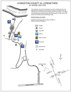 Directions to Al Lorenz Park:
From Main St Parking Lot: Turn right onto Main St. Turn left onto Grove St. Turn right onto Murray Hill Dr. Take the first left onto Al Lorenz Dr. Take the first right into the park.
From the Visitor Center parking lot: Turn right onto Visitor Center Rd. Take the first left onto Damsite Rd. Turn left onto Tallman Rd. In 1.2 mi, turn left into the park.
From Hogsback Overlook parking lot: Turn left onto Visitor Center Rd. Take the first right onto Damsite Rd. Turn left onto Tallman Rd. In 1.2 mi, turn left into the park.
A brief preview of the Springwater Trails Letchworth Series.
Our series of hikes will start at the northern end of the trail in the village of Mt Morris. The first hike (August) starts on the Greenway in Mt Morris to the Letchworth Branch intersection and upward past the Mt Morris Dam to Access C, a total of about 3.5 miles. In September, we will continue with a 4 mile hike to Access D, then 2.9 miles to Access E (Oct), 6 miles to Access F (Nov), 2.4 miles to Access G (Dec), 3.6 miles to Access H (Jan), 4 miles to Access K (Feb) and a final 3 miles (or so) in March to meet up with the main Finger Lakes Trail just past Portageville. The construction of a new railroad bridge over the Genesee at the south end of the trail has required re-routing of the Letchworth Branch onto road walks. We expect the trail to be reopened by March, but if necessary we will postpone our final hike until the trail is opened.
Hello, Springwater Trails! Our Vermont Long Trail outing in the Camel’s Hump area begins in a little more than a month. Pam and Bill are looking forward to a stupendous time exploring the Green Mountains, hoping the weather gods smile on us to produce sunny skies, starry nights, and moderate temperatures. While Camel’s Hump’s 4,083′ elevation is not the highest mountain in Vermont, it is the favorite of many (including Bill) because the summit is accessed only by hiking; no roads, gondolas, cable cars etc. are available. Being above treeline, the summit also features rare alpine vegetation.
Here’s what we have at this point in time:
Date deadline – It is essential that Pam and Bill know who and how many are attending along with their skill level (refer to the skill level discussion below). Accordingly if you plan to come and haven’t already registered, please do so by August 1. Registrations after August 1 will not be accepted. For the signup sheet, click here
Facilities – Most of us are planning to camp, and have already made our reservations, at Little River State Park, a few miles from Waterbury. All attendees are responsible for making their own camping arrangements, whether through the reservation system or coordinating with a ST member to share a site. Chances are the campground is fully booked by now. We are allowed to double up on campsites to a maximum of 8 people. However, the person(s) reserving the campsite have the discretion to determine how many more campers can share the site. We’re also limited to 2 cars per site regardless of how many campers share the site. The basic campsite fee covers 4 people. Additional fees are imposed for other campers up to the 8 maximum. For those without campground reservations and are unable to secure a site, accommodations are available in Waterbury or nearby.
Remember that if you registered for a cabin, the facilities are spartan. There is no bathroom inside, no linens for the beds, and hardly any furniture. Plan accordingly.
Keep in mind that aside from the exceptions noted in the “Schedule” below, you are responsible for your own meals. The person(s) who reserved a campsite is not obligated to provide food for the others sharing the site. Of course this does not preclude the site “owner” and fellow campers from working out some arrangements on the meals. For those disinclined to prepare meals, Waterbury offers a variety of restaurants.
Skill levels – As most of you are aware, Springwater Trails recognizes 3 skill levels: Climbers, Tourists, and Naturalists. For the latter two categories, the hikes under consideration thus far are congruous with Springwater Trails outings. In other words, if you hike as a Tourist on ST hikes, you can hike the Tourist hikes in Vermont.
In contrast, the Climbers’ hikes in VT will be substantially more difficult than the average ST hike in 3 respects (1) more miles, (2) greater elevation gain, and (3) rough terrain. For example, the Tuesday hike up Camel’s Hump will entail a 2,000’+ net elevation gain to the summit plus additional ups and downs on the remainder. And the route under consideration – hiking to the Winooski River from Camel’s Hump – will result in a 9 mile day.
So we ask prospective Climbers to honestly assess their capabilities before deciding which hike to take. Furthermore as hike leaders, we reserve the right to approve or disapprove any would-be Climbers who are either new to ST or inactive in the past year. This is out of concern for everyone’s safety.
Schedule – As you’ll note, there are still details to work out, some of which depend on your response to this message, primarily how many are coming and the skill levels. Here’s what we have thus far:
Monday, August 20 – afternoon arrival at Little River State Park, set up camp, and meet at Pam and Bill’s campsite (Elm Leanto) at 6:00 for a potluck dinner. Everyone should bring a dish to share. After the meal, we will review the hiking schedule and arrange car pools. If you choose to not participate in the dinner, you still should come to the meeting afterward at 7:30.
Tuesday, August 21 – Tourists and Climbers, please meet at Pam and Bill’s campsite (Elm Leanto) and be ready to leave the campground by 9:00. Climbers and Tourists will start at the same trailhead at the base of the east side of Camel’s Hump. They’ll hike the same route ( a steady but moderate ascent on the Dean Trail) for about a mile to a junction with the Monroe Trail. At this point, the Tourists will bear left and continue their moderate ascent on the Dean Trail to the ridgeline and the intersection with the Long Trail. The group will then decide whether to hike along the Long Trail, considering time and other factors. The return hike will be down the Dean Trail. Meanwhile, the Climbers will have taken the Monroe Trail (right fork from the junction) to Camel’s Hump Clearing and then up to the summit via the Long Trail. Climbers will descend Camel’s Hump southbound on the Long Trail to the junction with the Dean Trail which they’ll follow to the trailhead.
Naturists will hike to a clothing-optional hot spring. Just kidding, Freudian slip! Naturalists will hike 2 ½ miles on the Long Trail along the Winooski River. The trail is practically flat but there is one shallow ford across a brook. One interesting tidbit about this hike is that the Long Trail crosses the Winooski River on a newly-constructed footbridge. At this point, you’re at the lowest elevation of the entire 272-mile Long Trail at 325′ above sea level. And two of the highest points loom on either side of the river: Camel’s Hump to the south and Mt. Mansfield (VT’s highest summit) to the north.
Tuesday evening, we will gather at a restaurant in Waterbury for a group dinner.
Wednesday, August 22 – Please be ready to leave the campground by 9:00. The exact hikes are yet to be worked out. We have some promising options at other locations, ranging from Mt. Abraham (south) to Mt. Mansfield (north).
Thursday, August 23 – Pack up and return home. Those who wish to stay longer may consult with Bill and Pam on other options.
Other Activities – For those wanting to participate in non-hiking activities, Little River State Park features a lake with concessionaire rentals of canoes and kayaks. The Waterbury and Stowe areas feature numerous tourists attractions. On the culinary front, the home bases of Green Mountain Coffee, Ben & Jerry’s Ice Cream, and Cabot Cheese are nearby. The Von Trapp family estate near Stowe draws many Sound of Music junkies. A simple drive around the VT countryside is a great way to enjoy the scenery of the Green Mountains. Finally, we recommend a visit to the Green Mountain Club’s Headquarters on Rt. 100 between Waterbury and Stowe. The venerable GMC has been the steward of the Long Trail for over 100 years. The HQ features 3-D displays of the Long Trail, historical information, and publications for sale.
Questions? – contact Bill at 802-345-3773 or cookerhiker@msn.com. Feel free to offer suggestions and advice as well. We’ll listen! Looking forward to seeing everyone!
We will be hiking the original Rob’s Trail on Nature Conservancy land on the east side of Rt 15A, the connector trail down to Canadice Lake and the southern portion of the Canadice Lake Trail along the west side of the lake. Everyone should meet at the Rob’s Trail parking area just to the east of where Old Bald Hill Road South meets Route 15A in the Town of Canadice, Ontario County. Please come early to arrange for car pools. After the hike, we will have a social in the parking area. People attending the social should bring a dish to pass, their own beverage and something to sit on. In the case of rain we will go to the American Legion on Mill Street in Springwater for pizza.
There will be three different hikes with varying levels of difficulty. The three hikes will be:
- Up from Canadice Lake ~ 4 miles (the Climbers);
- Down to Canadice Lake ~ 4 miles (the Tourists);
- Along Canadice with no climbing ~ 2 miles (the Naturalists).
The Climbers and Naturalists will car pool from the parking area to the south end of Canadice Lake. Directions will be available at the start of the hike.
The Climbers will start at the south end of Canadice Lake and go along the lake trail to the Rob’s Trail connector trail and then continue around Rob’s trail to the parking area.
The Tourists will do the reverse hike, starting at the Rob’s Trail parking area. They will hike half way around Rob’s Trail and then descend to Canadice Lake, taking the lake trail out to the south end. They will use the Climbers cars to return to the parking area.
The Naturalists will do a flat hike next to Canadice Lake. This group will start with the Climbers and will walk for a mile or so along the lake trail and then return along the same trail to their cars.
Hikers wishing to complete the full 4 mile hike should consider whether they want to climb up Bald Hill or go down the hill. It is a 600 foot climb in 0.4 miles. The Climbers will be going up the hill and the Tourists will be going down (harder on the knees).
NOTE: Pets are not permitted on Nature Conservancy land at the top of Bald Hill. Hikers with dogs should go with the Naturalists or start with the Climbers and then join the Tourists when the two groups meet.
Directions: We will meet at the Rob’s Trail parking area on the east side of NY 15A (the entrance is actually on Old Bald Hill South. Directions are available here.
SPRINGWATERTRAILS HIKE FOR 4:00 pm (try to arrive at 3:55 PM), Sept. 2nd, 2018
LOCATION: Stony Brook State Park
Special Note: There is a seven dollar charge per car to enter the park. Anyone that would like to car pool to save the seven dollar charge can meet at 3:40 (leaving at 3:50 PM promptly) by the video store behind the Police/town hall station off Clara Barton street (Route 36) about 500 feet from the RT36 redlight on Main Street.
[envira-gallery id=”256245″]
HIKE DISCRIPTION: Hikers will split into three groups. Each group will walk at their own pace. Most of the climber trail is up and down hill, climbing at the beginning and down at the end of the hike. There are lots of steps to climb. Trails are most likely going to be wet and slippery so poles and traction devices or good treaded hiking boots are recommended. Tourists hike is flat or down hill until the East Rim trail where they will have to climb a short set of steps but then it is mostly down hill.
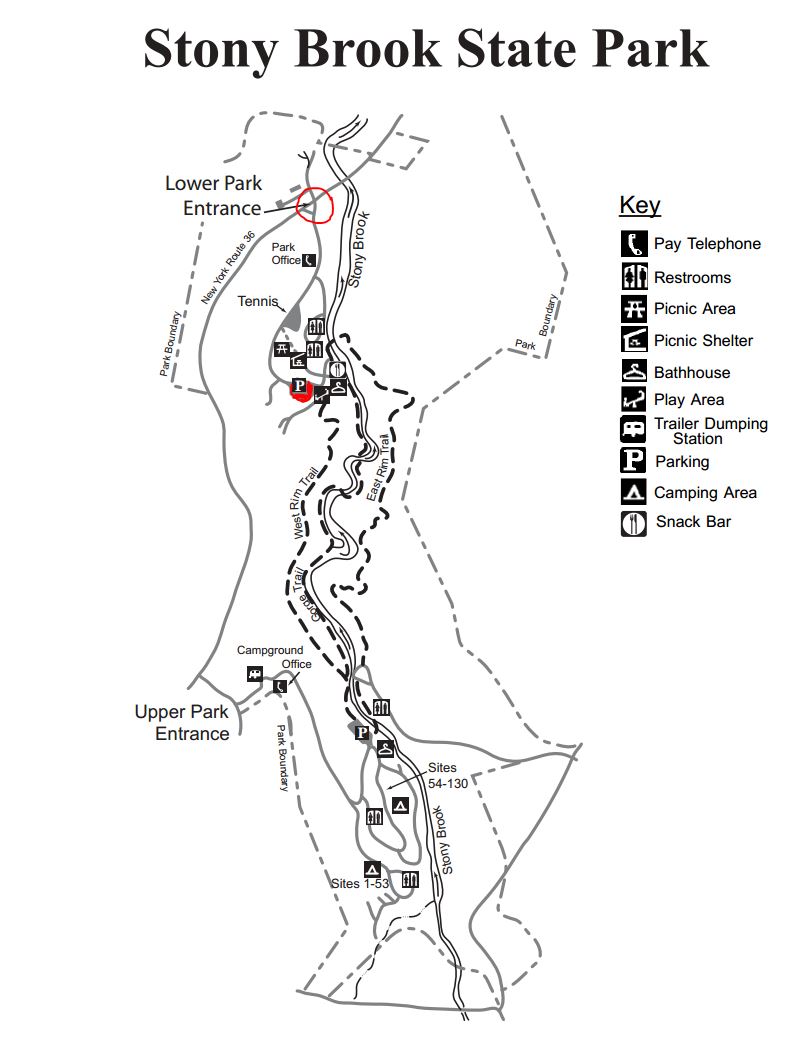 Climbers will start from the lower parking lot and climb the Gorge Trail starting at the swiming area and climb to the upper park crossing over the stone bridge and returning back to the lower park along the East Rim Trail.
The Tourists will car pool to the upper park and walk along a flat trail in the pines until they are just above camping sites 1-53. They will make thier way down through camp sites 1-53, 54-132 and 133-135 passing the playground and crossing over the stone bridge.They will return back to the lower parking lot via the East Rim trail.
Naturalist can stay in the lower park and enjoy the scenery along the creek area. The Gorge trail could also be walked for a short distance until the stairs are reached. There is a lot of climbing beyond this point.
RECOMMENDATIONS: The weatherman is calling for showers on Sunday so be prepared. That’s not as bad as the last Stony Brook hike when we had 20 inches of snow on the ground.
After hike social will be in the picnic area next to the lower parking lot. Bring a dish to pass or a five dollar donation would be appreciated. Hot dogs and Hamburgers will be provided.
DIRECTIONS: From Downtown Dansville take RT.36 South for about 4 miles. Turn left into StoneyBrook State Park. Drive to the main parking lot where we will divide into our three groups. The Tourists will car pool to the upper park to start their hike. Directions to the carpool location are also available.
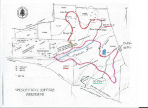
This week we return to HiTor WMA above Naples. All hikers will meet at the parking area on Dewolf Rd. (A on the map below – click on the map to see a bigger version). Poles and good tread are recommended. There, we will break into our 3 groups.
The Climbers: Carpool to DEC entrance at Donley/Shay and Parish Rd (B). The initial entry is a grassy laneway that meets up with the blue trail near Conklin Gully. At the next trail intersection hikers will bear left onto the orange trail ascending to Brink Hill Rd. Once on Brink, turn left and follow the road to the stop sign, turn right, uphill to the end of Dewolf.
The Tourists will follow the FLT orange trail (C) on Brink Hill Rd to the blue trail on the grassy access road. We will then turn right and follow the access road along the edge of Parish Gully to the parking area on NY-245 near the intersection with Parish Hill Rd. Cars will be available to transport the tourists back up to their cars and the social. This hike is mostly downhill.
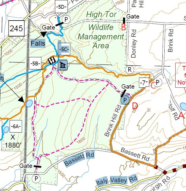 The Naturalists will enter High Tor 0.2 mile south of access 7, on a DEC access road (D). There is a For Sale sign on the property across from the DEC parking area. This hike will be an out and back, allowing the Naturalists to adjust the length of the hike to meet the wishes of the hikers. The road continues straight though the first intersection. At the second intersection, the naturalists should turn right to come to the lean-to and enjoy a long view of Canandaigua Lake. Bring your binoculars for Bird and duck spotting on the 2 ponds. From the lake view , turn around and follow the same road back to the cars.
Following the hike, join us for a social at Amy’s. The main dish will be provided. Please bring a dish to pass and your own beverage (or make a small $5 contribution to the social fund)
Directions from Naples:
From Naples/ Main St. travel SOUTH to join Rt. 53S, up the hill, away from town. Turn LEFT on Yates County Rd #21/ Italy Valley. Turn LEFT at the curve onto Bassett Rd. Church on opposite corner. Turn LEFT on Brink Hill Rd. Turn right onto Dewolf Rd at the stop sign. Follow the road to the top of the hill (A).
 We need someone to meet Amy at the Parish Hill parking area on Rt. 245 @ 1:30pm to leave a vehicle for the tourist’s return. Please comment or email Amy if you can do this. Thanks!
Note: An alternate route is possible from Rt 245 following Parish Hill Rd. Bear right at the curve to stay on Parish Hill then left on Shay Rd, first right on Brink Rd which turns into Dewolf Rd. A large portion of Parish Hill Rd is still dirt so the Bassett route is easier.
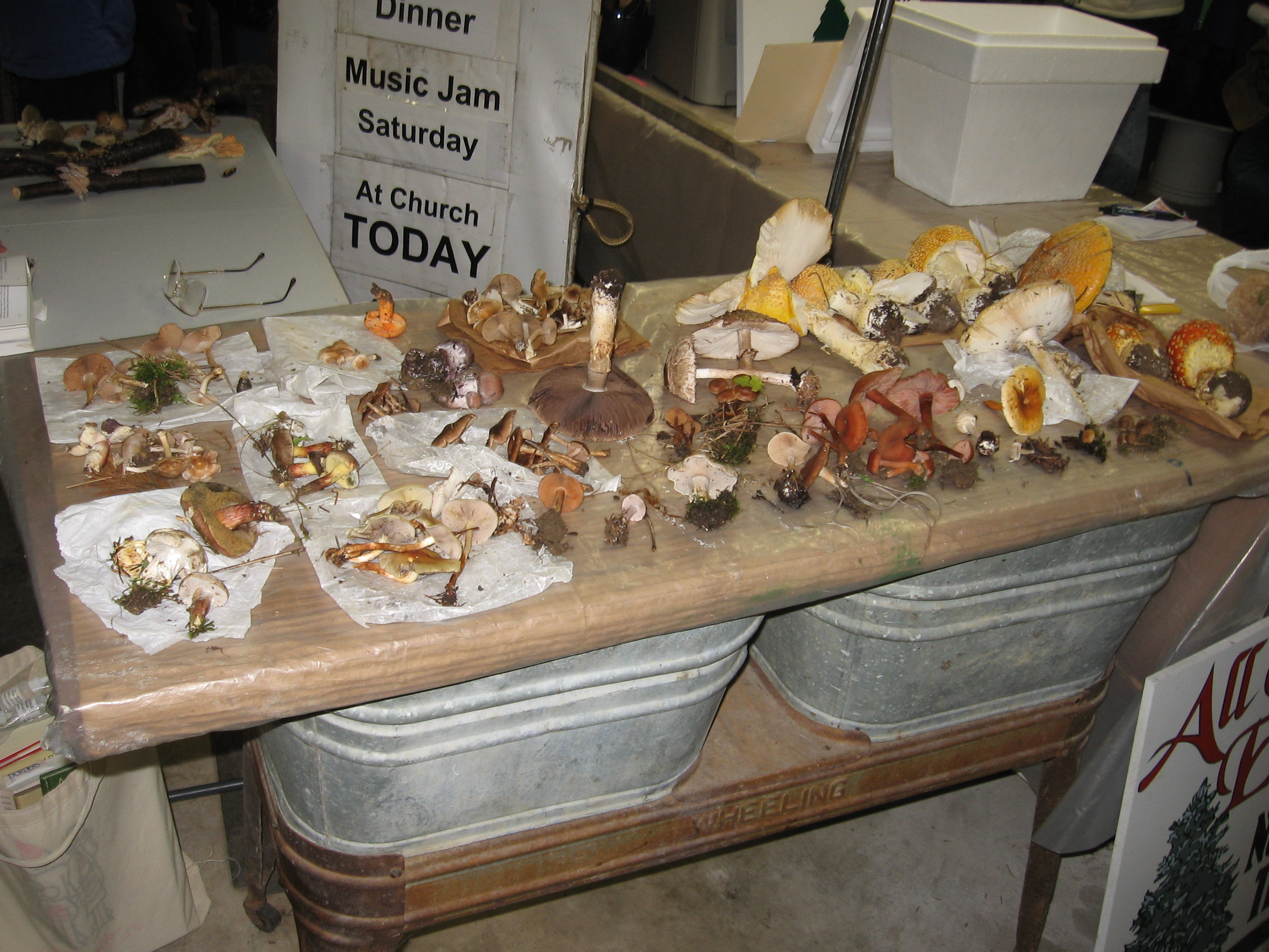
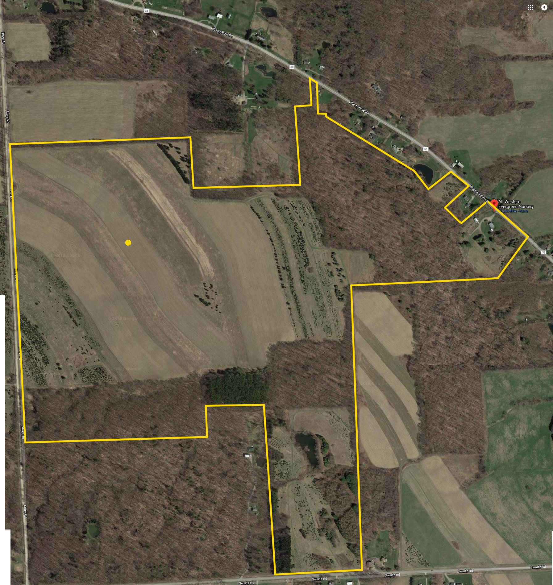 Welcome to the Fifth Annual Mushroom Foray at the All Western Evergreen Farm. Three hiking groups are planned, all starting and ending at the farm house. We will explore much of the farm, enjoying views of the valley and close-ups of the floral and mycological specimens.
Please plan to arrive early (1:45) to sign in and to sign the RAMA liability forms.
Friendly dogs are welcome on the hike; however, a leash will be needed near the farm house and you can expect a few other dogs will be hiking with you.
Paper bags and paper plates for collecting and displaying mushrooms will be provided. Those who want to learn how to collect mushrooms will be instructed by Gene and Georgia, and any other Rochester Area Mycological Association members who will be our guests.
 The Climbers will follow the driveway up to the fields, and explore to the south and west, to explore the varied forests for wild mushrooms. Check out between the Christmas trees if you are looking for unusual mushrooms.
The Tourists will follow the driveway, stopping occasionally to explore the woods for mushrooms. When they reach the field, head to the right through several Christmas tree plantations.At the corner, follow the trail back into the woods. If time permits, return to the field and head west to a hidden corner of the field with some spectacular Christmas trees if you live in a large mall.
The Naturalists will start exploring under and behind the Red Cedars by the parking area. The woods to the right of the trail up to the main fields are likely full of mushrooms, but you will find some swampy areas, so don’t get lost.
All hikers should check their watches and return to the parking area by 4:00 to identify their collections.
Once again we are fortunate to have several RAMA members with us who have volunteered to identify the mushrooms collected between 4 and 4:30 p.m. After identification of the mushrooms, join us for a social (4:30 – 6:30 p.m.) hosted by Katherine at her house. Katherine will make two soups – Enchilada Chicken Soup and Vegetable Barley Soup. Please bring a dish-to-pass or make a small contribution to support the socials. Bring your own beverage. Dogs will want to stay in your car during the social.
We will begin all the hikes at 6840 Liberty Pole Road where there is ample parking at the Christmas tree loading area between the tall Western redcedar and Morton Building and Nursery beds. Follow the parking signs. When we return from our foray, the mushrooms will be displayed for identification on paper plates on the tables indoors in the Morton Building or the basement depending on the weather.
If using GPS, please try 6840 Liberty Pole Road, Dansville, NY 14437 (the mailing address) so as to not have a problem.
From Springwater: Go west from the Springwater light on NY-15 North. Just past the top of the hill and after rounding the tight curve, turn left on CR 38 (Liberty Pole Road). The farm is on the left (the high side) 1.1 miles from NY-15 at 6840 Liberty Pole Road after you cross Carney Hollow Rd. There is a sign for the All Western Evergreen Nursery.
From Geneseo: Go south on NY-63. About 6.4 miles after passing NY-408, turn left on CR-1 (Groveland Scottsburg Rd) at Groveland Station. This road becomes CR 1A (Springwater Scottsburg Rd) at Scottsburg (Route 256) and then Liberty Pole Road after you cross Stagecoach Road (CR 71), and finally CR-38 (still Liberty Pole Rd) after crossing Reeds Corners Rd (CR-29). It is 7.1 miles from Groveland Station to All Western Evergreen Farm. The farm is on the right (the high side).
From Honeoye: Take 20A west to Hemlock and 15A south to Springwater. Then follow the Springwater directions above.
From Rochester: Take I-390S from Rochester. Use Exit 9 for NY-15 Lakeville. Turn left onto NY-15. Stay on NY-15 for 16.5 miles, through Lakeville, Livonia, Conesus and Websters Crossing. When NY-15 curves to the left, turn right onto CR-60 (Carney Hollow Rd). Take the first right onto Liberty Pole Rd. The farm is on the left (the high side).
This Sunday, Springwater Trails is hosting the fifth annual tri-modal hike around Canadice Lake. Bring your bike, your kayak and walking shoes and celebrate one of the two undeveloped Finger Lakes. Canadice Lake is unique among the Finger Lakes with a road and trail around the entire lake at water level. We will enjoy this trail on Sunday on foot and bicycle, and will add in some kayaking to complete the tri-modal event.
There are four hikes planned, depending on the interests of the participants.
Tri-modal: We will start on our bikes, traveling north from the Canoe Launch along Canadice Lake Rd. At the north west corner of the lake, we will enter the trail and continue around the lake, returning to the Canoe Launch. From there, it will be a short kayak across the lake, where we will leave our boats and hike north on the trail, planning to turn around at the Rob’s Trail bridge. Finally, we will return across the lake in our boats.
Bi-modal Climbers: The climbers will start in kayaks and spend about an hour on the lake, ending at the west side of the lake. They will beach their boats, leaving their paddles and life jackets in the boats, and turn left on the trail to hike around the south end of the lake and back to the Canoe Launch.
Bi-modal Tourists: The tourists will do the reverse hike of the climbers. They will carpool with the Naturalists to the south end of the lake, and then hike in to where the Climbers have left their boats. This hike will be slightly more than an hour, giving time to check the fall flowers near the trail. The Tourists will use the Climber’s kayaks to return across the lake to the Canoe Launch.
Naturalist Hikers: Hikers are invited to join the Naturalists for a hike along the Canadice Trail. Hikers will carpool to the southern entrance to the trail, and will hike for one hour, and then turn around and return to the cars and the Canoe Launch.
Following the hike, join us for a pot luck social at the Canoe Launch. We will grill hot-dogs. Please bring a dish to pass and your own beverage or make a donation to the social fund.
NOTE: Some of you may have noted that our plans depend on equal numbers of Climbers and Tourists. This may require some flexibility on your part and adjustments on the precise routes.
So, dust off your bike, load up your car and come enjoy a sunny fall afternoon on Canadice Lake.
Directions: All participants should meet at the Canoe Launch near the south end of Canadice Lake. Please arrive early enough to unload your boat and bike and stage them for the start of the event.
NOTE: the Canoe Launch is 1.5 miles south of the motor boat launch site.
From Springwater: Purcell Hill access: Go North on 15A for 7.6 miles. Turn right on Purcell Hill. At the end of Purcell Hill Rd, turn right onto Canadice Lake Rd on the east side of the lake. The Canoe Launch is 2.9 miles south.
From Springwater: Johnson Hill access: Go North on 15A for 2.7 miles. Bear right on Old Bald Hill Rd S and then an immediate right on Johnson Hill Rd. Take the first left onto Canadice Lake Rd. The Canadice Canoe Launch is 1.8 miles north of Johnson Hill Rd.
From Honeoye: Take Co Rd 37 South from 20A, Turn right after 3.7mi to stay on Co Rd 37. Stay straight onto Burch Hill Rd. At the lake, turn left onto Canadice Lake Rd. The Canadice Canoe Launch is 2.1 miles south of Burch Hill Rd.
From Hemlock and Rochester: Take NY Rt 15A south from Rochester through Lima and Hemlock. Just past Hemlock, Rt 20A goes left. Continue straight on 15A for 3,2 miles after 20A. Turn left on Purcell Hill. At the end of Purcell Hill Rd, turn right onto Canadice Lake Rd on the east side of the lake. The Canoe Launch is 2.9 miles south.
Please obey the No Parking signs at the launch area.
Looking for brochure.or mailing list so I can receive it in the mail.
Nothing opens up for mailing list.
There’s all kinds of very bizarre ads and post for viagra and other drugs above on calender page.
Please let me know if there’s a brochure available