
Hikes led by Springwater Trails are generally held on Sunday afternoons and appear in this calendar in green.
| Sun | Mon | Tue | Wed | Thu | Fri | Sat |
|---|---|---|---|---|---|---|
| Lehigh Valley Trail Hike or Bike in Rush, NY 2:00 pm Lehigh Valley Trail Hike or Bike in Rush, NY @ Stevens-Connor Lehigh Valley Lodge Apr 6 @ 2:00 pm – 4:00 pm Come join us for a leisurely hike or bike along the Lehigh Valley Trail on Sunday April 6th! With its flat even surface, the trail is a hidden gem for walking, hiking, jogging, biking. It is a vital link in … Continue reading | ||||||
| Ontario County Park at Gannett Hill Hike-Naples 2:00 pm Ontario County Park at Gannett Hill Hike-Naples @ Lookout Parking area Apr 13 @ 2:00 pm – 4:00 pm  This is one of our group’s favorite hikes! Ontario County Park at Gannett Hill is one of the highest points in Ontario County and located in the scenic Bristol Hills. At an elevation of 2,256 feet above sea level, you’ll … Continue reading | ||||||
| No Hike-Easter Break 2:00 pm No Hike-Easter Break Apr 20 @ 2:00 pm – 4:00 pm No hike has been scheduled for this date due to the Easter Holiday. Enjoy the break, spend time with loved ones and eat chocolate bunnies. This will give you something to burn off next week  | ||||||
| Hike Rob’s Trail – Hemlock Lake side 2:00 pm Hike Rob’s Trail – Hemlock Lake side Apr 27 @ 2:00 pm – 4:00 pm Join us on Sunday April 27th to hike the west side of Rob’s Trail, the DEC/Nature Conservancy property in the northeast corner of Hemlock Lake! Options are to hike out and back to the south along the trail from the … Continue reading |
The hike on Sunday, October 18, 2015 in Avon, is designed as a combo event. At 2:00, the Avon Preservation and Historical Society (APHS) is sponsoring a presentation by Kelly Cole entitled the 1876 Opera Block. In order to allow hikers to attend this presentation, our hike has been moved to 3:30. Join us at 2:00 at the Avon Historical Society. Following the presentation, our hike is just a mile west.
**update October 18th – you may appreciate an extra pair of sock & shoes for the after-hike social & ride home, and perhaps an umbrella in case it rains during the hike.
Starting at the Erie-Attica Trail trailhead parking lot off Farmers Rd, we will hike on the Erie-Attica Trail and the Genesee Valley Greenway (aka Greenway, aka GVG).
From the Erie-Attica Trail trailhead, all hikers (except Flatlanders) will head west on the Erie-Attica Trail. Crossing the Genesee River, we enter the Town of Caledonia. The Erie-Attica Trail (EAT) ends at the Genesee Valley Greenway (albeit someday the EAT will extend further westward to W River Rd aka Co Rd 84). We will turn left and follow the Greenway as far as seems reasonable. At about 4:30, we will turn around and retrace our route back to the cars.
Four hiking groups are planned for. Presently planned routing: The Climbers will follow the Greenway across Rt 5 and across Rt 20. The trail goes parallel to Batzing Rd, where we expect to turn around.
Meanwhile, Tourists will likely turn around at Rt 20, and the Naturalists will turn around at Rt 5. Flatlanders will utilize the Erie-Attica Trail (EAT) segment situate east of the Farmers Rd trailhead which is a paved segment to Horseshoe Blvd alongside a pond. Additionally, as capable, they may utilize the EAT westward from the Farmers Rd trailhead over the truss bridge and beyond, before returning to the trailhead. See some points of interest on the Greenway at the FOGVG website.
Directions:
From the 1876 Opera Block: From Genesee St, go round the traffic circle a bit shy of 360o, and head west on Rts 5&20 (aka West Main Street). After about 0.8mi, turn right on Farmers Rd (partially paved and part gravel surface). The parking area is on the right, just after you pass under the flyover for the former RR truss bridge (now the Erie-Attica Trail truss bridge).
From Springwater: Take Rt 15A North. In Lima, turn left on US 20. Follow Rt 20 for 7.6 miles (you will cross over I390, pass through East Avon and the Village of Avon. After the traffic circle in the village, continue on Rt 20 for 0.8mi and turn right on Farmers Rd. The parking area is on the right, just after you pass under the flyover for the former RR truss bridge (now the Erie-Attica Trail truss bridge).
After-hike social ~5:45PM at Tom Wahl’s Restaurant picnic pavilion (behind the restaurant), 283 East Main St, Avon, NY. For more details about the social click here, and then scroll down as necessary to the heading for the after-hike social.
**notes for future Avon hikes: 1) An alternative hike routing involving multiple access points on the EAT & GVG including that utilizing access from Fowlerville Rd which gives quickest access (.85 mile hike) to the “rubbing” marker post, listed in hike #5 of the “Wegmans Passport to family wellness” Program booklet for the Genesee Valley Greenway State Park was considered for this 10/18 Avon hike, but decision was made to defer such possibilities to a future hike. Vehicle placement logistics and transport of such a hike would utilize more time than a simple “out & back” type hike. 2) The Genesee Valley Conservancy’s railroad-bed-trail just south of the village of Avon and south of Ashantee’s historic and scenic five arch viaduct (the former Erie RR viaduct on the Avon to Mt Morris route) over Conesus Creek, runs south off Fowlerville Rd essentially at the jct with NYS Rt 39 (aka Avon Geneseo Rd). This trail can be a future S/T hike. 3) There is also a short trail segment in vicinity of the Ashantee five arch viaduct, and as well at nearby Avon Downs Park which is situate at the end of Spring St (respectively aptly named for the race track at “Avon Downs” and the natural spring that once was the center of a spa resort edifice and activities in Avon.
***Toward establishing future S/T hike & Genesee River paddle event possibilities in and near Avon, … S/T kayakers may want to take time to assess the “Genesee River access point” at the NYSDEC fishing access area at the southeast corner of Rts 5&20 and the Genesee River. This is approximately opposite the Rts 5&20 and Farmers Rd intersection. (The locale is sometimes referred to as Berry’s Park, and you’ll find a blue and gold NYS Education Dept historic marker there titled “Berry’s Tavern”.)***
 Last Sunday’s hike (Oct 18th) was on old railroad lines, and was nice and flat. So watch out, this Sunday we will be doing a hike that is anything but flat. Although not a technically difficult hike, this will be a strenuous hike for each of the hike levels. For steep downhills, walking poles will provide some appreciated extra stability.
The hike will start an an elevation of 1600ft to the east of Hornell and will climb to 1800 over the first half mile. Views should open up here at the top, allowing us to look north toward Wayland and Springwater, before starting down to 1200ft over about 2 miles. After crossing the road and Big Creek (Its name on the maps, and an accurate name too), the Climbers will have an opportunity to earn their name over the final mile and a half with a climb up to nearly 1700ft and back down to the cars.
This hike will be a one-way hike, which means some shuttling cars and car-pooling. Although all groups will walk the same trail, we will start and end at different points to allow for different length hikes. In an attempt to simplify the car shuttling and to save some gas, we will all meet at the Wayland Parking lot behind the firehall at 1:00PM (leaving promptly at 1:15).
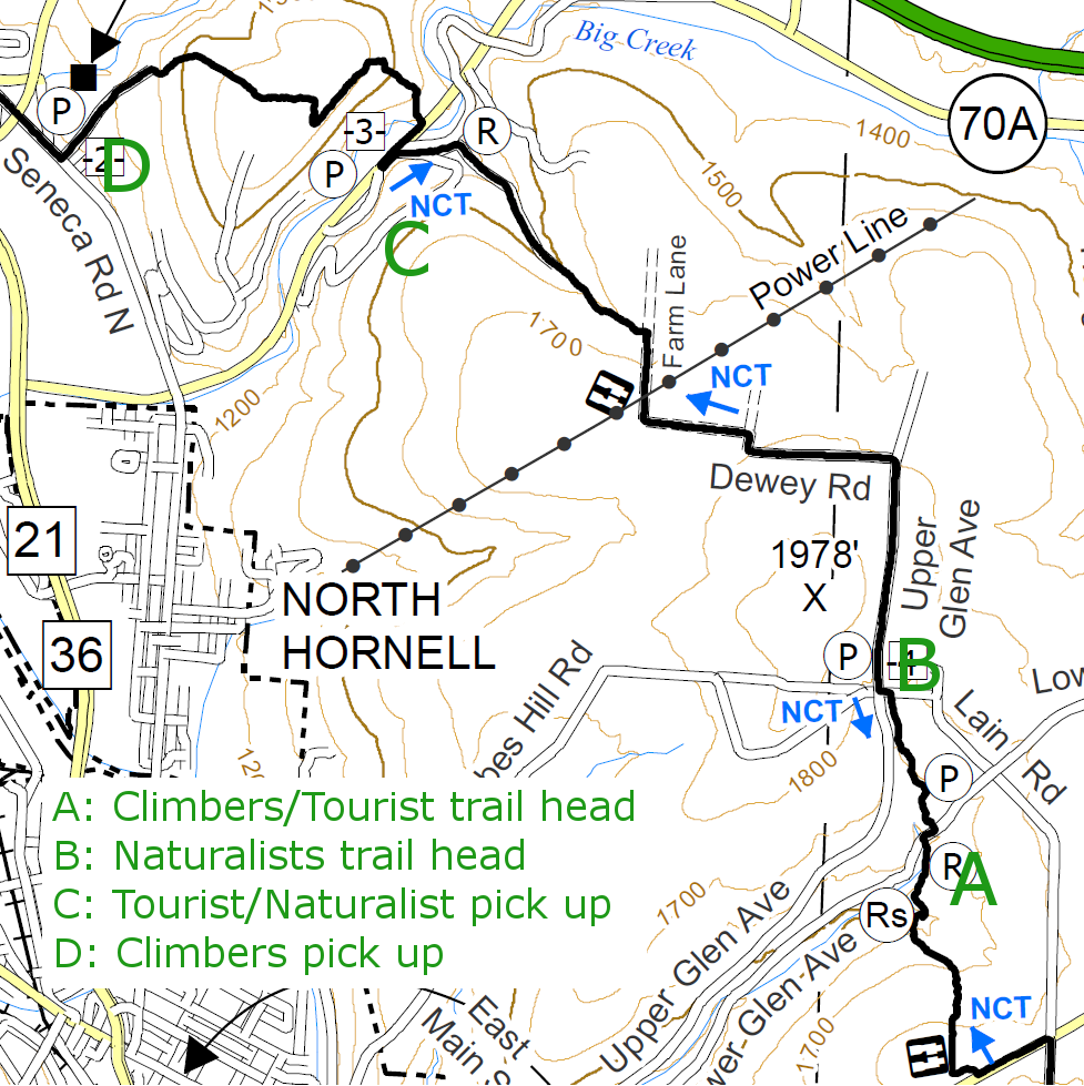 Climbers will leave some cars at the Econo Lodge (D) in North Hornell (7462 Seneca Rd N, Hornell, NY) which will be the end of the hike. From there, we will car pool to Lower Glen Ave (A) to start the hike.
Tourists and Naturalists will leave some cars on Big Creek Rd (Steuben CR70A) opposite Beltz and Patton Roads (C), which will be the end of their hike. From there we will car pool to Lower Glen Ave (A) where the Tourists will start their hike. The Naturalists will then drive to Laine Rd and Upper Glen Ave (B) to start their hike at the high point of the trip. The Naturalists and Tourists will meet on the way down to CR70A and their cars.
The challenge will then be to find all of the cars we have left at the start of the hikes. Gene will be in charge of that!
Following the hike, we will visit a restaurant in Hornell for dinner and to review the hike. Please come with ideas for Winter hikes since it is time to start that planning.
Directions:
All Hikers to meet at Wayland Parking (42.568606, -77.590562):
Plan to be at the parking area at 1:00. We will distribute maps and select cars for carpooling. We will leave at 1;15 for Hornell. Please be on time. If you can’t make the parking lot by 1:15, you can try to meet us at the trail head on Lower Glen Ave.
From Springwater: Head south on NY-15 to the light in Wayland. Turn right on Rt 63 (W Naples St). In about 150ft, turn right between the Fire House and the Sugar Creek building to get to the parking lot in the center of the block.
From Dansville: Head east on Rt 63 toward Wayland. Just before the second light in Wayland (at NY-15) turn left between the Fire House and the Sugar Creek building to get to the parking lot in the center of the block.
From Naples and N Cohocton: Head west on NY-21S toward Wayland. Go through the light at NY-15. In about 150ft, turn left between the Fire House and the Sugar Creek building to get to the parking lot in the center of the block.
Carpool directions to Hornell:
To Econo Lodge (42.363603, -77.666032): End of Climbers hike.
From Wayland: Exit from the parking lot next to the Fire Department. Turn left on Rt 63, then right (south) on NY-15/NY-21. Stay on NY-21S for 18.5 miles. At the stop sign, turn left onto Seneca Rd N. Take the second left onto Filter Plant Rd.
To Big Creek Rd and Beltz Rd (42.363675, -77.648883 ): End of Tourist/Naturalist hike.
From Wayland: Exit from the parking lot next to the Fire Department. Turn left on Rt 63, then right (south) on NY-15/NY-21. Stay on NY-21S for 18.5 miles. At the stop sign, turn left onto Seneca Rd N. In 0.9mi turn left onto CR 70A (Big Creek Rd). After 0,9 mi, turn right on Patton Rd and immediate left onto Beltz Rd.
To Lower Glen Ave: (42.336779, -77.620044): Trail head Climbers/Tourists
From Wayland: Exit from the parking lot next to the Fire Department. Turn left on Rt 63, then right (south) on NY-15/NY-21. Stay on NY-21S for 18.5 miles. At the stop sign, turn left onto Seneca Rd N. In 3.4mi turn left onto Main St for 0.5mi. Turn left onto Tobes Hill Rd, then an immediate right on Florence St which becomes Glen Ave after the left corner. In about 0.6 miles, take a slight right onto Lower Glen Ave. The road will cross the creek three times. At the third crossing, look for signs for the Finger Lakes Trail and the North Country Trail. There is shoulder parking available. If you get to Laine Rd, you have gone too far.
From the Econo Lodge: Turn left (south) onto Seneca Rd for 2.5 miles. Turn left onto Main St for 0.5mi. Turn left onto Tobes Hill Rd, then an immediate right on Florence St which becomes Glen Ave after the left corner. In about 0.6 miles, take a slight right onto Lower Glen Ave. The road will cross the creek three times. At the third crossing, look for signs for the Finger Lakes Trail and the North Country Trail. There is shoulder parking available. If you get to Laine Rd, you have gone too far.
From Big Creek Rd (CR 70A) and Beltz Rd: Head Northeast on CR 70A for 2.3 miles. Turn right onto Butchers Corners Rd CR 56. Take the first right onto Hungry Hollow Rd and the next left to stay on Hungry Hollow Rd for 1.5mi. Make a sharp right onto Middle Rd (Lower Glen Ave). After crossing Laine Rd, head down the hill (about a quarter mile) and look for Finger Lakes Trail signs at the creek crossing.
To Tobes Hill Rd, Laine Rd and Upper Glen Ave Intersection (42.342806, -77.622447): Trail head for Naturalists.
From Lower Glen Ave trail head: Head east up Lower Glen Ave. Turn left onto Laine Rd. There is shoulder parking at the intersection with Upper Glen Ave and Tobes Hill Rd.
Every fall, Trail Maintenance and Trail Quality hold two meetings for trail maintainers and any other interested parties. One of the meetings, intended for hikers or workers on the main trail between Portageville (M 7) through Watkins Glen (M 14), the Letchowrth, Bristol Hills, or Crystal Hills Branches and the Queen Catharine
Marsh and and Montour Falls Historic Loops, will be held at the Bath Fire Hall.
Each meeting will be informed by your specific questions and the problems you have encountered, but both will include about any trail management policies which you need to be familiar with. This years meeting will feature Marty Howden, Western Regional Coordinator for the FLTC and Coordinator of the Chainsaw Training. Marty and Lynda Rummel, FLTC VP for Trail Quality, will talk about the status of the NPS & USFS chainsaw and cross-cut saw certifications and the increased emphasis on working safely in the field.
Who should attend? All hikers who enjoy the Finger Lakes Trail system including Springwater Trails members who wish to help maintain the Bristol Hills Branch.
For more information, please see the full meeting announcement.
10 AM sharp. Bring your lunch, your questions, and your ideas. Coffee, apple juice and some breakfast goodies provided.
Directions:
From Springwater: Take Rt 15 South for 6.9 miles. Turn left to merge onto I-390 South for 20.2 miles. Take exit 38 from I-86 (Rt 17) for Bath. Turn left onto W Washington St. Turn right at the 2nd cross street on W Morris St. The firehouse is on the left about a half mile down Morris St (past Pulteney Park). Parking is available behind the fire house.
*** First off – let’s give a reminder – – – annually the first Sunday in November (Nov 1st in 2015, yep that is this hike), there is a time change from “Eastern Daylight Savings Time” to “Eastern Standard Time” (fall back one hour), so it gets dark one hour earlier and progressively days further shorten (sunset happens earlier and earlier) as we head toward Winter Solstice (near the end of December). So be sure you’ve reset your clock, or you may be an hour early for the hike and standing around wondering where all the other hikers are!
That said . . . This Sunday, November 1st, 2015, at 2PM the Springwater Trails hike will actually be a part of a planned Friends of the Genesee Valley Greenway (FOGVG) hike. Springwater Trails will be joining FOGVG for this hike (an official FOGVG annual event coupled with the FOGVG annual meeting and optional additional activities following the hike), that these wonderful FOGVG folks have planned on the Genesee Valley Greenway (GVG) in the Geneseo environs. {Approximate areas of Cuylerville (Mt Morris to Piffard) would pretty much encompass the GVG Geneseo environs.}
Please note the hike event schedule as set out below. It is a bit different in schedule than most S/T hikes in a number of ways. One difference, we’ll be syncing with an additional group of hikers, and following lead as it is FOGVG’s hike plan, so some organizational time beyond our S/T norm may be required. Another difference, the hike starts at 2PM and there is a program that starts at 4PM in Geneseo, so hikers should be sure to arrive far enough in advance of 2PM for covering incidentals and organizing hike groups, so the hike can start at 2PM.
*** Below is the hike event schedule pretty much pulled from the Facebook page of FOGVG, on 10/2/2015 from a Sept 25th post. The hike on the GVG definitely covers two towns, Leicester (including the hamlet of Cuylerville) and its eastern neighboring Town of Geneseo.
– – Please note at present, 10/21/2015, details are basically set for this hike, but minor changes for this hike event may occur, so a small chance that not all salient info may be presented in this Hike Event Announcement. Please feel free to check the FOGVG website (or FOGVG Facebook page) for possible future updating of hike details.- –
⇒Announcing: FOGVG Annual Event at the Geneseo United Methodist Church, Route 63 and Court Street, Geneseo, New York, Sunday, November 1, 2015. The event consists of a Hike, Program, Dinner & Meeting.
2:00 PM – Guided Hike – Meet at the Genesee Valley Greenway (GVG) Cuylerville Parking Area (on Rt. 20A): Hike the Greenway north to enjoy picturesque farmlands and large ponds that are a favorite with birders. Return to Cuylerville for a 3.5 to 5 mile hike or post a car at the GVG Piffard Parking area for a 3.5 to 4 mile one-way hike.
4:00 PM – (optional) Program – Meet at Geneseo United Methodist Church, Route 63 and Court St., Geneseo, New York. The History & Development of the WAG Trail by FOGVG member and Senior DEC Forester Ron Abraham The WAG Trail is a 9-mile multi-use recreation trail and historic transportation corridor in Allegany County, extending from the Village of Wellsville to the Pennsylvania state line. The Trail follows the route of the former Wellsville, Addison and Galeton Railroad along the upper Genesee River, just a few miles from its headwaters. New York State acquired the property in 2009 and substantial progress has been made in developing this trail with 8 miles currently open to the public.
5:30 PM – (optional) Dish-to-Pass Dinner: Bring your favorite dish-to-pass, your table service, and join us for a delicious meal. Beverages will be provided. (Springwater Trails group will bring the “potluck tote” with paper plates, plastic utensils, etc, but S/T hikers should feel free to be environmentally friendly by bringing their own durable flatware and silverware at this tables and chairs equipped indoor social venue.)
6:30 PM – (optional) Brief FOGVG Meeting, For members and potential members.
Everyone Welcome: Join the hike, Come for the program, Stay for dinner See You in Geneseo! Geneseo United Methodist Church.
S/T hikers and others are welcomed to become members of FOGVG, annual member dues are $ 20 for an individual, $25 for a family. You need not be an FOGVG member to attend any of the components of this hike event.
ADDITIONAL S/T INFO FOR THIS GVG HIKE
Hike Meet Location (further defined): ⇒ GPS Coords: 42.777222, -77.870382 on the north side of NYS Rt 20A (concurrent NYS Rt 39) in the hamlet of Cuylerville (Town of Leicester) at the GVG trailhead parking area (mile 29-30 of the GVG). Point of reference – Cuylerville is situate a bit southwest of the village of Geneseo. [hint: Parking area is very near (just east of) an ~85o pronounced bend in Rts 20A/39, also described as west of Boyd Parker Memorial Park, and northeast of The National Hotel.] Parking is available at the trailhead. (Look for the “yellow trail gates”, set back some distance from the public roadway.) Carpooling by S/T hikers is encouraged, in consideration of limited vehicle parking space at the trailhead parking area.
{You’ll note directions are given by: landmark, direction, compass orientation, and GPS coordinates. Something for everyone.}
After-Hike Social (in sync with FOGVG plans): Please bring a dish to pass. S/T will be bringing the tote/tub utilized at potluck socials, to this social event.
Directions to the hike Meet Locale:
From Springwater: Take NY-15N west from the flashing light for 1.5 miles. Turn left on Liberty Pole Rd (CR 38). This road changes names and numbers (CR 1A and then CR 1) but continue for 8 miles. Turn right onto NY-63N for 9.4 miles. Take a sharp left turn onto US-20A W (NY 39 also). The parking area is on the right in 2.4 miles just before US-20A turns a sharp left in Cuylerville.
From Wayland: Take NY-21 south to Interstate 390. Turn right to take I390N for 22 miles to exit 7 – NY 408. Turn right onto NY-408N then slight left to continue on NY-63 for 3 miles. Take a sharp left turn onto US-20A W (NY 39 also). The parking area is on the right in 2.4 miles just before US-20A turns a sharp left in Cuylerville.
From Honeoye: For the entirety of the trip from Honeoye to Cuylerville, you’ll take US-20A W for about 22 miles of driving to the trailhead parking area. Its just that simple! But routing can be a bit confusing in some places, such as a junctions and where there are concurrently running routes, so watch signs carefully. ⇒Further detailed description (if you need it): Follow US-20A W from the hamlet of Honeoye through the hamlet of Hemlock and villages of Livonia and Geneseo and then heading into the small hamlet of Cuylerville. (Watch signs for US-20A carefully on the SW side of the village of Geneseo, or you may go astray.) SW of village of Geneseo, US-20A W & NY-39 W & NY-63 S all briefly run concurrently. Staying on US-20A (& concurrently running NY-39 W), from the US-20A (NY-39 also) split from NY-63 at the SW side of Geneseo, you’ll then travel 2.4 miles to the trailhead parking area located on the right just before US-20A (NY-39 also) turns a sharp left in Cuylerville. (By-the-way, as a digression, a short-cut on Big Tree Rd in the towns of Richmond and Livonia, circumventing a segment of US-20A, saves a mile but not any time).
From Rochester: Take I390 S to Exit 8 (NY 20A). Turn right onto 20A W for 12 miles. The parking area is on the right in 2.4 miles just before US-20A turns a sharp left in Cuylerville.
Directions to the Dish-to-Pass Social at Geneseo United Methodist Church (42.802549, -77.827199):
Head east on US 20A for 2.6 miles. Take a slight left to stay on NY 63N (20A goes straight). In 1.2 miles, the church is on the left. Parking is in the back.
Carpool: A non-supervised carpool from Springwater Town Hall is scheduled to leave the Town Hall promptly at 1:15. Please be there at 1:00.
If you look great in Autumnal Orange (or blaze orange), and even if maybe you’re thinking you don’t, well, … this hike is during Bow Hunting Season for big game, so wearing some of that orange would place you right in fashion this time of year.
Below this double line, you’ll find ancillary information, relevant but not crucial to this hike.
This 11/1/2015 FOGVG hike is principally represented in the Wegman’s Passport to family wellness booklet for the Genesee Valley Greenway State Park as hike #7. W Passport booklets for the GVG will be available at the start of this hike, for those who do not already have one and would like one. – – – If you are thinking “what is that?”, then here’s an explanation.
A facsimile from a previously published description – – -Some hikers may be interested to know there is a “Wegmans Passport to family wellness Program booklet” for the GVG which consists of a total of 14 listed hikes on the GVG. The Wegman’s “Passport to family wellness” Genesee Valley Greenway State Park booklets are available (free) at select Wegman’s locations (likely W store locations closeby to the GVG) at the store’s service desk. (You may want to call first, if it would mean a special trip for you. Wegman’s Chili-Paul location in the Town of Chili, does have them currently.) Picking one up (and maybe several for fellow hikers) on your own assures that you have one in hand. A limited number of these “Passport to Wellness” GVG booklets will be available at the hike.
(Of note, S/T has three hikes on the GVG this autumn hiking season, 10/18, 11/1, & 11/8.)
Included here is a FOGVG brochure map.
FOGVG contact info. Telephone: (585)-658-2569 or fogvg@frontiernet.net [658 exchange is considered a Mount Morris exchange.]
——————————————————————————————————————–
For those folks unaware the GVG is now a NYS Park (a linear park) and as such now gets more attention from NYS in programming. The GVG is still fostered by the FOGVG, the long standing group which assisted and continues to assist in GVG development and maintenance.
– – – SOME HYPERLINKS TO ADDITIONAL INFO ABOUT THE GENESEE VALLEY CANAL. – – –
For hikers interested in history of the Genesee Valley Canal (GVC), here is an online article published in Fall 1994 edition of Rochester History. It now is published on-line on the Rochester Public Library website.
You’ll also find some photos of various canals in NYS at the following URLs, listed as links.
http://www.nygeo.org/index.htm
http://www.nygeo.org/EEC_Locks.html
http://www.nygeo.org/EEC_Structures.html
If you’ve a keen identifying eye, and check out some of these photos, you’ll find one is of the culvert with a road through it, passing under the Erie Canal, which is located on . . .yep, you guessed it, Culvert Rd. Located about a mile east of Medina, Orleans County, NY. This is the only place in NYS that the roadway went under the canal, and it still exists today. And if you’ve driven the roadway recently, you’ll likely find two inosculating trees north of the culvert on the west side of the road and within view of the culvert. Or perhaps you’d say they’re hugging, intertwining, or twisting (Chubby Checker, anyone?)
A S/T article about the GVC when we hiked part of the GVG in Letchworth State Park in Autumn 2012.
Facebook page of FOGVG – Southern Tier section GVG hikers.
tidbit (historic and present): In Cuylerville, the historic National Hotel (built circa 1840), still in operation today, was an important business along the canal route.
This unique opportunity for a guided hike at low water level in the Niagara River gorge features Devils Hole State Park as the start point and heads down hill to the river and then up-river in the gorge before returning. { GPS Coordinates of Devil’s Hole State Park = 43.13346, -79.046684 } The hike is listed as 5 1/2 hours but do not let that scare you, because with the distance to cover the hike must have a slow pace and substantial time for “look see”. But, do consider this is a hike with elevation gain & loss & stairs! This hike is offered on Saturday November 7th, 2015 & again on November 14th, 2015.
While this hike is a trek to drive from Springwater environs, it may be a rare opportunity (perhaps even a once in lifetime hike for you) for such a hike. That’s why its posted on this website for hiker awareness and consideration. Perhaps consider carpooling with some other interested S/T hikers. (The Niagara Region of New York State Parks does schedule multiple guided hikes per year, within a number of Niagara Region NYS Parks, among one in the past has been Whirlpool State Park. So, if you were to search in subsequent years at the right time, you’ll likely find some hike of interest.) (note: currently, autumn 2015, Whirlpool State Park is undergoing construction along the top gorge edge where the trail along the gorge rim & viewing area of the Whirlpool in the river gorge is situate, so some access is partially limited.)
This hike is listed on the NYS Parks website as “registration required”. Registration Phone # (716)-282-5154.
FYI – Devils Hole State Park has numerous steps / stone stairways from the top of the gorge to reach river gorge level (think gorge trail at Stony Brook State Park). Albeit of note between the Rainbow bridge and Devils Hole SP there are numerous ways to reach the river gorge at river level from the top of the river gorge. You may want to discern what route specifically will be used for this hike, by calling the registration phone number, if you are concerned about you ability on stairs.
——————————————————————————————————————–
*** MORE INFO *** some of it excellent hikers’ tips and little known info.
Between the Rainbow Bridge area of Niagara Falls State Park (just north of the falls, yep, ‘Niagara Falls’) and Devils Hole SP, there are at least four ways to get from the top of the gorge to the bottom of the gorge. But first know that for the entirety of the described length – Rainbow Bridge northward to Devils Hole SP – there is a rim trail along the upper gorge, and there also is a paved multi-use (bikeway & walking path) that was formerly half the laneage of the Robert Moses Parkway (roadway) in this section. Several years ago half the laneage of this section of the Robert Moses Parkway (closest to the river gorge shoulder) was decommissioned and given over to a multi-use recreational trail, that’s why its wide and paved. (Currently there are plan proposals to make further alterations along this corridor.)
Listed here are four specific ways into the river gorge: 1) Devils Hole State Park trails (substantial number of stairs) ; 2) there is a trail in Whirlpool State Park, figure on stairs here too (Whirlpool SP is contiguous to DeVeaux Woods State Park which is situate on the opposite {east} side of Robert Moses Parkway) ; 3) there is the “Great Gorge Railway Trail” (yep, there was a former tourist railway into the lower gorge, it closed down approx in the 1930s) that leaves the Gorge Rim Trail and heads northward sloping downward into the gorge (the Great Gorge Railway Trail trailhead is situate about 2/3 the distance south from the Whirlpool Bridge and 1/3 the distance north from the Rainbow Bridge) which in looking at a map has its trailhead ~ on an east-west plane of Cedar Avenue as a reference point (also could be described as nearly adjacent the area where the downward traversing sewage treatment plant road crosses under Robert Moses Parkway) ; 4) EASY PEASY there is a newly recommissioned elevator most folks do not yet know about free and open to the public. The elevator building, a rectangular shaped brick building along the top edge of the gorge, can be found a short distance south of the “Niagara Gorge Discovery Center” (another hyperlink) the funky shaped kinda roundish/satellite-ish looking building formerly known for years as the Schoellkopf Geological Museum. (There is an outdoor man-made climbing wall there too, point of reference.) The elevator building could also be described as being on the “campus area” of the “Niagara Gorge Discovery Center” area of Niagara Falls State Park.
[detail note: The “Niagara Gorge Discovery Center” situate to the west side of Robert Moses Parkway should not be confused with the nearby Aquarium of Niagara (also a round shaped building located at 701 Whirlpool St, east side of the street) which lies just east of the Robert Moses Parkway. (Of note, these two edifices are pedestrian accessible to one another, via the “flyover pedestrian bridge” that crosses above the Robert Moses Parkway and serves as a tourist and hiker walkway connection. The pedestrian bridge landing points are as follows, west-landing: the grounds or campus of the “Niagara Gorge Discovery Center”, east-landing: the west side of Whirlpool St which is directly across the street {Whirlpool St} from of the Aquarium of Niagara).]
The elevator building is immediately adjacent the parking area for the “Niagara Gorge Discovery Center”. The top lobby of the elevator “SL” street level and the much smaller bottom lobby have limited hours of operation (about 8 hours a day, or so, but hours vary by seasonal dictate). Hours of operation are posted on the entry door of the elevator building. Please note, elevator lobby hours are not the same as the nearby “Niagara Gorge Discovery Center” hours.
At URL immediately below is a photo of the elevator building and the “Niagara Gorge Discovery Center”. https://lh5.googleusercontent.com/-fSKbL86nUuU/VWJwgOSGjHI/AAAAAAAAH8A/W98ccpzeO84/s408-k-no/
The elevator at the bottom lets out to the newly built seasonal boat storage area for the American side “Maid of the Mist” boats. There is a self guided tour pamphlet (available free in the upper lobby of the elevator building) depicting points of interest in this immediate area, and trails lead both north and south from this point near river level. The elevator shaft itself, is the repurposed and reinforced shaft of the former Schoellkopf Power Plant. The ruins of the power plant and the power plant’s demise are pointed out via the self guided tour pamphlet. So you’re definitely getting some history via the elevator ride and self guided tour pamphlet.
Still not sure where the “Niagara Gorge Discover Center” and the elevator to the river level are? (Both of which are within Niagara Fall State Park.) Well, as a reference point, Howard Johnson’s Closest to the Falls and Casino Hotel, at 454 Main Street, Niagara Falls, NY (which in part has the iconic bright orange roof HoJos is known for) is within sight of this part of Niagara Falls State Park. This HoJos is situate at the corner of Main Street and the Robert Moses Parkway, and is situate such that it is not crowded by other buildings, so is is easily discerned in line of sight. Niagara Falls State Park itself runs from south and east of Goat Island to north of Niagara Gorge Discover Center” & beyond.
If you go to this Devils Hole SP hike, and have the time either before the hike or immediately after, well, … this elevator ride and self-guided tour is a “gotta do”, and its free.
If you go to this hike, and are looking for more hiker’s tips / options and some info to use for after the hike, well …, exclusive info for S/T members may be something you wanna read.
And, perhaps too, if you go to this hike, you’ll come back from it having “Niagara Fever” with impetus & idea that this is an “away” hike worth planning for a future S/T Sunday hike. Yep, even though it would be an exceptional distance to travel to a Sunday hike.
— Some hyperlinks on salient area history —
lots more photos, mostly older historic of the Schoellkopf Power plant area
one website of many, that gives accounts of the Schoellkopf Power plants, and developments of the area
An on-line search of – Schoellkopf Power Station – , and such similar terms will produce many results for reading.
*** Quiz questions. What is America’s oldest State Park? While on this related topic, what is the smallest NYS Park. (hint, these are not one and the same.)
L
O
T
S
O
F
W
H
I
T
E
S
P
A
C
E
… between the Quiz questions, and now the answers.
- Now named Niagara Falls State Park and initially authorized by law in 1885 as Niagara Reservation, this is the oldest State Park in the USA. The establishment to preserve the natural beauty of Niagara Falls, reclaiming the area from industry that had built up along the falls area did not come easy.
- New York State’s smallest state park is The State Park at The Fair, on the NYS Fair Grounds near the Syracuse area.
After last week’s most enjoyable joint hike, program and social with the great hikers of FOGVG, a simple autumntime Sunday afternoon hike and social may seem somewhat mundane, but I don’t have Don’s penchant for finding other neat Sunday afternoon events
We’ve selected another section of the scenic Genesee Valley Greenway, this one being a 1.5 mile spur, from Pentagass Rd, north of Nunda, to Nunda Village, an easy flat trail with mixed surface. We will meet at the trailhead on Pentagass Rd. From Dansville, go west on SR 436 to Nunda village. Take a right on N. Walnut St., which looks like the first cross street after entering the village. A slight right jog after Massachusetts St. will put you on Creek Rd., which becomes CR 15. Make a left on Pentagass Rd. and, a short ways down, you’ll see the trailhead on your left. Park on the right, along the north side of Pentagass Rd.
Naturalists will spot a car at the south end of the spur, near the corner of State (408) and Vermont, in the village. Then, drive back to pentagass and hike to the south end, 1.5 miles. Tourists will hike to the south end and back, 3 miles. Melissa will lead the climbers on a circular hike which will include the spur and part of the original GVG.
All hikers will pass a Wegman rubbing post so, bring your GVG passport and a pencil. You may have picked up 1 or 2 more rubbings in the last month. Remember, if you get at least 6 rubbings in this book, the Wegman Corp will reward you with coupons redeemable in their stores. By staying healthy, prolonging your life, and increasing your appetite, by hiking, you will increase the fortunes of the second generation of the Wegman family, by continuing to purchase merchandise from their stores. Now, how’s that for a win-win?
Finally, we will wrap up this fine day at an old favorite, the Sunrise in Dansville, even though we’ll get there at sunset. It’s located on Main St., between Ossian and Perine, with a big parking lot in the back. We can meet in this parking lot, before the hike, at 1 PM, to carpool to Nunda, no later than 1:15.
Carpools:
This unique opportunity for a guided hike at low water level in the Niagara River gorge features Devils Hole State Park as the start point and heads down hill to the river and then up-river in the gorge before returning. { GPS Coordinates of Devil’s Hole State Park = 43.13346, -79.046684 } The hike is listed as 5 1/2 hours but do not let that scare you, because with the distance to cover the hike must have a slow pace and substantial time for “look see”. But, do consider this is a hike with elevation gain & loss & stairs! This hike is offered on Saturday November 7th, 2015 & again on November 14th, 2015.
While this hike is a trek to drive from Springwater environs, it may be a rare opportunity (perhaps even a once in lifetime hike for you) for such a hike. That’s why its posted on this website for hiker awareness and consideration. Perhaps consider carpooling with some other interested S/T hikers. (The Niagara Region of New York State Parks does schedule multiple guided hikes per year, within a number of Niagara Region NYS Parks, among one in the past has been Whirlpool State Park. So, if you were to search in subsequent years at the right time, you’ll likely find some hike of interest.) (note: currently, autumn 2015, Whirlpool State Park is undergoing construction along the top gorge edge where the trail along the gorge rim & viewing area of the Whirlpool in the river gorge is situate, so some access is partially limited.)
This hike is listed on the NYS Parks website as “registration required”. Registration Phone # (716)-282-5154.
FYI – Devils Hole State Park has numerous steps / stone stairways from the top of the gorge to reach river gorge level (think gorge trail at Stony Brook State Park). Albeit of note between the Rainbow bridge and Devils Hole SP there are numerous ways to reach the river gorge at river level from the top of the river gorge. You may want to discern what route specifically will be used for this hike, by calling the registration phone number, if you are concerned about you ability on stairs.
——————————————————————————————————————–
*** MORE INFO *** some of it excellent hikers’ tips and little known info.
Between the Rainbow Bridge area of Niagara Falls State Park (just north of the falls, yep, ‘Niagara Falls’) and Devils Hole SP, there are at least four ways to get from the top of the gorge to the bottom of the gorge. But first know that for the entirety of the described length – Rainbow Bridge northward to Devils Hole SP – there is a rim trail along the upper gorge, and there also is a paved multi-use (bikeway & walking path) that was formerly half the laneage of the Robert Moses Parkway (roadway) in this section. Several years ago half the laneage of this section of the Robert Moses Parkway (closest to the river gorge shoulder) was decommissioned and given over to a multi-use recreational trail, that’s why its wide and paved. (Currently there are plan proposals to make further alterations along this corridor.)
Listed here are four specific ways into the river gorge: 1) Devils Hole State Park trails (substantial number of stairs) ; 2) there is a trail in Whirlpool State Park, figure on stairs here too (Whirlpool SP is contiguous to DeVeaux Woods State Park which is situate on the opposite {east} side of Robert Moses Parkway) ; 3) there is the “Great Gorge Railway Trail” (yep, there was a former tourist railway into the lower gorge, it closed down approx in the 1930s) that leaves the Gorge Rim Trail and heads northward sloping downward into the gorge (the Great Gorge Railway Trail trailhead is situate about 2/3 the distance south from the Whirlpool Bridge and 1/3 the distance north from the Rainbow Bridge) which in looking at a map has its trailhead ~ on an east-west plane of Cedar Avenue as a reference point (also could be described as nearly adjacent the area where the downward traversing sewage treatment plant road crosses under Robert Moses Parkway) ; 4) EASY PEASY there is a newly recommissioned elevator most folks do not yet know about free and open to the public. The elevator building, a rectangular shaped brick building along the top edge of the gorge, can be found a short distance south of the “Niagara Gorge Discovery Center” (another hyperlink) the funky shaped kinda roundish/satellite-ish looking building formerly known for years as the Schoellkopf Geological Museum. (There is an outdoor man-made climbing wall there too, point of reference.) The elevator building could also be described as being on the “campus area” of the “Niagara Gorge Discovery Center” area of Niagara Falls State Park.
[detail note: The “Niagara Gorge Discovery Center” situate to the west side of Robert Moses Parkway should not be confused with the nearby Aquarium of Niagara (also a round shaped building located at 701 Whirlpool St, east side of the street) which lies just east of the Robert Moses Parkway. (Of note, these two edifices are pedestrian accessible to one another, via the “flyover pedestrian bridge” that crosses above the Robert Moses Parkway and serves as a tourist and hiker walkway connection. The pedestrian bridge landing points are as follows, west-landing: the grounds or campus of the “Niagara Gorge Discovery Center”, east-landing: the west side of Whirlpool St which is directly across the street {Whirlpool St} from of the Aquarium of Niagara).]
The elevator building is immediately adjacent the parking area for the “Niagara Gorge Discovery Center”. The top lobby of the elevator “SL” street level and the much smaller bottom lobby have limited hours of operation (about 8 hours a day, or so, but hours vary by seasonal dictate). Hours of operation are posted on the entry door of the elevator building. Please note, elevator lobby hours are not the same as the nearby “Niagara Gorge Discovery Center” hours.
At URL immediately below is a photo of the elevator building and the “Niagara Gorge Discovery Center”. https://lh5.googleusercontent.com/-fSKbL86nUuU/VWJwgOSGjHI/AAAAAAAAH8A/W98ccpzeO84/s408-k-no/
The elevator at the bottom lets out to the newly built seasonal boat storage area for the American side “Maid of the Mist” boats. There is a self guided tour pamphlet (available free in the upper lobby of the elevator building) depicting points of interest in this immediate area, and trails lead both north and south from this point near river level. The elevator shaft itself, is the repurposed and reinforced shaft of the former Schoellkopf Power Plant. The ruins of the power plant and the power plant’s demise are pointed out via the self guided tour pamphlet. So you’re definitely getting some history via the elevator ride and self guided tour pamphlet.
Still not sure where the “Niagara Gorge Discover Center” and the elevator to the river level are? (Both of which are within Niagara Fall State Park.) Well, as a reference point, Howard Johnson’s Closest to the Falls and Casino Hotel, at 454 Main Street, Niagara Falls, NY (which in part has the iconic bright orange roof HoJos is known for) is within sight of this part of Niagara Falls State Park. This HoJos is situate at the corner of Main Street and the Robert Moses Parkway, and is situate such that it is not crowded by other buildings, so is is easily discerned in line of sight. Niagara Falls State Park itself runs from south and east of Goat Island to north of Niagara Gorge Discover Center” & beyond.
If you go to this Devils Hole SP hike, and have the time either before the hike or immediately after, well, … this elevator ride and self-guided tour is a “gotta do”, and its free.
If you go to this hike, and are looking for more hiker’s tips / options and some info to use for after the hike, well …, exclusive info for S/T members may be something you wanna read.
And, perhaps too, if you go to this hike, you’ll come back from it having “Niagara Fever” with impetus & idea that this is an “away” hike worth planning for a future S/T Sunday hike. Yep, even though it would be an exceptional distance to travel to a Sunday hike.
— Some hyperlinks on salient area history —
lots more photos, mostly older historic of the Schoellkopf Power plant area
one website of many, that gives accounts of the Schoellkopf Power plants, and developments of the area
An on-line search of – Schoellkopf Power Station – , and such similar terms will produce many results for reading.
*** Quiz questions. What is America’s oldest State Park? While on this related topic, what is the smallest NYS Park. (hint, these are not one and the same.)
L
O
T
S
O
F
W
H
I
T
E
S
P
A
C
E
… between the Quiz questions, and now the answers.
- Now named Niagara Falls State Park and initially authorized by law in 1885 as Niagara Reservation, this is the oldest State Park in the USA. The establishment to preserve the natural beauty of Niagara Falls, reclaiming the area from industry that had built up along the falls area did not come easy.
- New York State’s smallest state park is The State Park at The Fair, on the NYS Fair Grounds near the Syracuse area.
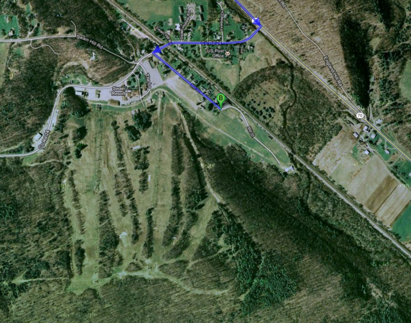 The Robinson Loop off of the main Finger Lakes Trail in Swain, NY, offers us the terrain you would expect near a ski resort.
All groups will set off from the parking area at the end of Mill Street in Swain. Hikers will travel on the main FLT (white blazes) for about .5 miles along an old rail bed to a gate where the yellow loop branches off.
At this point, the Naturalists will being to follow the Yellow Loop. They will drop down and hike eastward for approximately 1 mile along a stream, parallel to the main trail. The Yellow trail ends at a junction with the main trail at which point the hikers will make a sharp right turn and head back towards Swain. Total, about 2 miles.
The Tourist Group and Climbers will continue on the level White Trail for another mile to the beginning of the Blue Loop. They will make a gradual climb of about 1 mile to a lovely view on Isaaman Hill. They will continue on along the edge of a field for another mile. At this point the blue trail joins the Orange Loop. Decision time!
Tourists will go right on the Orange trail for a 1 mile walk down hill through a beautiful gully, back to the main trail, then hike west for about a mile back to Swain. Total hike 4 miles.
Climbers ( intrepid group that they are) will go left on the Orange Loop and continue for another 2 miles or so, through the woods, mainly down hill, until it rejoins the main trail about .5 miles form the start. The total hike for Climbers is about 5 miles.
After the hike, we will gather at the Sierra Inn in Swain for food and beverages.
Directions
Hikers are welcome to carpool from the Town Hall in Springwater or from the Municipal Parking lot on the right side of Clara Barton St (Rt 36) in Dansville across from Church St. If you do not carpool, we will meet at Mill St in Swain. Since you may need to drive as part of the carpool, please bring these directions with you.
If you want to carpool from Springwater, meet at the Town Hall on Rt 15 0.2 miles south of the flashing light. Please meet at 1:00 and be ready to leave promptly at 1:15 for Swain.
If folks want to carpool from Dansville, meet at the Municipal Parking on Rt 36 about 300 feet south of Rt 63 at 1:15. We will leave promptly at 1:30 and drive to Swain.
Directions from Springwater:
Take rt 15 south through Wayland to I360 N. Turn right onto I390. Take exit 4 (NY 36 Dansville). Turn right on NY 36S for 6.4 miles. Turn right onto NY 70 N, for 7.4 miles. Turn left onto Co Rd 24 and take the first left onto Mill St.
Directions from Dansville:
Head southwest on Rt 36 for 7 miles past Stony Brook Park. Turn right onto NY 70 N, for 7.4 miles. Turn left onto Co Rd 24 and take the first left onto Mill St.
We are taking the week off. Happy Thanksgiving.
We took one week off from hiking, but it is time to get back on track before the December holidays. So come join us on the Springwater Trail in east Springwater, for some good views, good climbs, and good conversations.
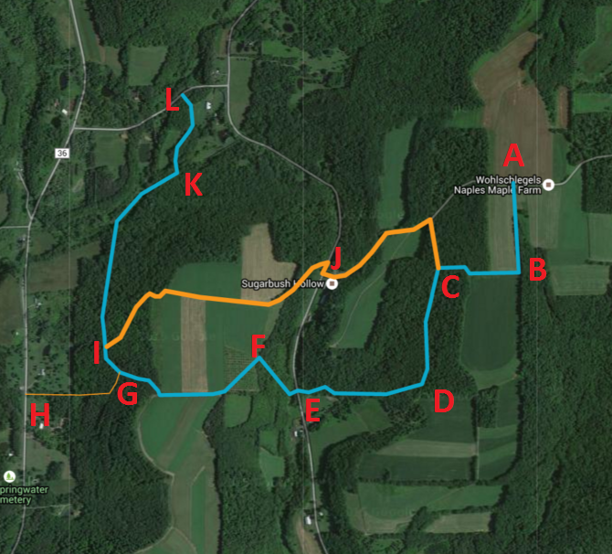 Please park along Pardee Hollow at Coates Rd (J).
All hikers will car pool to entrance (L) and hike the new section of the Springwater Trail through Punky Hollow.
The Naturalists will hike the main trail to point (I) and then switch to the alternate orange trail up over the hill and down to the cars (J) (about 2 miles LKIJ).
The Tourists will hike the main trail across Pardee Hollow (E) and up into the middle of the Sugarbush. At (C) we will switch to the orange trail to come out on Coates Rd, which we will follow down to the cars. ( and then take the orange trail out to Coates Rd and down to the cars. (LKIGFEDCJ) About 3 miles with two climbs.
The Climbers will follow the main blue trail the entire way to the top of Coates Rd (A), then will head down Coates Rd to the entrance back onto the trail to C, back down to Pardee Hollow and then up the road to the cars at J (about 3.5 miles LKIGFEDCBACDE).
After the hikes, you have the option of enjoying good food and fellowship of your fellow hikers, at the Mountain View Inn, in Atlanta.
Directions:
From Springwater, go north on 15A, right on Wheaton Hill Rd. (CR 16), right on Wetmore Rd, right on Tabors Corners Rd. Go left on Pardee Hollow Rd. On the corner, is the Punky Hollow Farm, where this year’s Fiddlers Fair was held. Continue on PHR, by going right at the T. Park across from Coates Rd. and look for our sign. Try to get there by 1:45.
For the Mountain View Inn, go down Pardee Hollow till it ends at Rowe Rd. (CR 38) and go right to SR 21. Go left on 21, and then, right, into Atlanta.
Additional directions available here.
Looking for brochure.or mailing list so I can receive it in the mail.
Nothing opens up for mailing list.
There’s all kinds of very bizarre ads and post for viagra and other drugs above on calender page.
Please let me know if there’s a brochure available