
Hikes led by Springwater Trails are generally held on Sunday afternoons and appear in this calendar in green.
| Sun | Mon | Tue | Wed | Thu | Fri | Sat |
|---|---|---|---|---|---|---|
| Hike at Mt. Morris Dam, Mt Morris 2:00 pm Hike at Mt. Morris Dam, Mt Morris @ Mt Morris Dam hike Mar 2 @ 2:00 pm – 4:00 pm 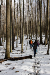 This Sunday, we will hike the Finger Lakes Trail (FLT) starting at the Mt. Morris Dam and Visitors Center Parking Lot. We expect to enjoy the height of winter as we follow the east rim of the Letch worth … Continue reading | ||||||
| Winter Hike, Ski or Snowshoe – All Western Evergreen Farm, Springwater 2:00 pm Winter Hike, Ski or Snowshoe – All Western Evergreen Farm, Springwater @ Liberty Pole Road Mar 9 @ 2:00 pm – 4:00 pm 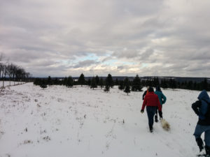 You are invited to hike, ski or snowshoe on a very special private property near the Northwestern corner of Springwater on the 248 acre All Western Evergreen Nursery & Christmas Tree Farm! Note, this hike was rescheduled from 2/16/25 date which … Continue reading | ||||||
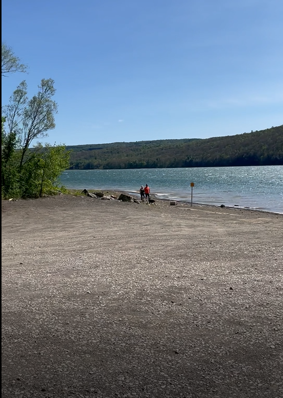
| Hike at Sandy Bottom Park, Honeoye 2:00 pm Hike at Sandy Bottom Park, Honeoye Mar 16 @ 2:00 pm – 4:00 pm  Our hike this Sunday, March 16th will be at Sandy Bottom Nature Trail starting from Main Street across the street from Birdhouse Brewery (8716 Main Street Honeoye, NY 14471). This is where we will park and gather. The hike will … Continue reading | ||||||
| Canadice Westside Trail Hike, Canadice 2:00 pm Canadice Westside Trail Hike, Canadice Mar 23 @ 2:00 pm – 4:00 pm  This week’s hike will be on Canadice Lake Trail! This is an easy, 1.8-mile each way hike along the shore of the lake; the trail is level and well-maintained and the lake views are lovely. For most hikers it will … Continue reading | ||||||
| Hike at Affolter’s Farm, Hemlock 2:00 pm Hike at Affolter’s Farm, Hemlock Mar 30 @ 2:00 pm – 4:00 pm More details about this very special hike coming soon! Please check back. |
Notice: Rain appears to be likely this afternoon. Bring rain gear. We will move the social to the pavilion in Hemlock Park in the case of actual rain.
We will explore the south end of Canadice Lake and its surrounding terrain with the travel method of your choice (hike, bike or paddle), starting at the Canoe Launch (the southernmost lake access point) on Canadice Lake Road (southeast corner of the lake). Meet at 3:45pm and park on the road shoulder near the kiosk. If you are bringing a boat or a bike, allow extra time for unloading. Note: event time change.
Hikers: Those interested in a gentler walk may head south along Canadice Lake Road to the southern end of the Canadice Lake Trail and follow it as long as you like, then return. The side trail through the ponds south of Canadice Lake is a nice addition to this route. The terrain is flat with a well-worn mulched trail.
Paddlers: Put in at the south launch site and paddle the shores as far as you’d like, then return.
Cyclists: Starting at the southeast corner of Canadice Lake, head north along the Canadice Lake Road, west on Purcell Hill Road and back to the start on the Canadice Lake Trail for a total of about 7.8 miles. The Lake Trail is fairly level and a decent surface for road bikes with medium tires, better for hybrid or mountain bikes. For those who prefer road riding, continue north on Canadice Lake Road to loop back on Canadice Hollow Road and Purcell Hill Road, returning to the start for a total of about 9 miles. If that’s not enough, riders can pick up another 4 miles by heading south to the intersection with County Road 37 and back.
Optional Social: Bring a dish to pass or your own food and we will have a picnic at the south boat launch.
DIRECTIONS: From Springwater: Head north on 15A and cut over to Canadice Lake Road. via Wheaton Hill or Johnson Hill Road. The south access area will be on the left.
From Canandaigua, Honeoye and Hemlock: Take Route 20A to the Canadice Lake Road intersection. Go south 6.5 miles to the southernmost lake access area, on your right.
From Rochester: Take Route 390 south to the 5&20 exit, go east to Lima, then south on Route 15A. After Hemlock, turn left on Route 20A and right on Canadice Lake Road. The southernmost access area is 6.5 miles down, on your right.
Bare Hill Unique Area is a beautiful natural spot situated in the Town of Gorham, Ontario County, and the Town of Middlesex, Yates County. Prepare to relish sweeping views along with the sights and sounds of songbirds, wildflowers, fungi, meadow plants and local faunae.
The Hike:
We will start from the trailhead at 5821 Van Epps Road Rushville, NY 14544 meeting at 3:45pm for a 4:00pm start. NOTE: hike time change!
Naturalists and Tourists will combine the lowest trail with the pond shortcut. Climbers will take the upper trails.
Directions:
From Naples, take 245 north to Middlesex. Turn left onto north 364, then left onto County Route 10/North Vine Valley Road. Then take a right onto Bare Hill Road, followed by a left onto Van Epps Road.
From Canandaigua, take 364 south to a right onto County Route 10/North Vine Valley Road. Then take a right onto Bare Hill Road and a left onto Van Epps Road.
Social:
Will be held after the hike at Bob and Ruth’s Vineyard Restaurant, 204 N. Main Street, Naples NY 14512 (585) 374-5122
Bee Pollination Tricks of the Trade!
This Sunday, we will have the opportunity to enjoy the unique arboretum at Durand-Eastman Park. Included in their rhododendron collection, are a few trees called mountain laurels, which are common in the Appalachian hills. The mountain laurel is in bloom at this time. It has a unique trick for getting bees to transfer their pollen, which we will attempt to demonstrate.
We will meet in the circle at the end of Log Cabin Rd. at 3:45pm. Note hike time change. We will then hike the trail, at the south end of the park, to the junction of Zoo and Pine Valley Rds., enter the arboretum at Pine Valley, and walk to the mountain laurels for the attempted demonstration. Afterwards, hikers seeking a more vigorous walk are welcome to enjoy some of the park’s nice hiking trails and return to the Log Cabin Rd.
Directions:
From the Springwater area, go north to I-390. In Monroe County, use the right lanes to get on I-590 north. At junction with 490, stay on 590 north. Get in middle lane, avoid 104 exits, and stay left to go toward Sea Breeze. At the fourth roundabout (you’ll see a bunch of flags), go ¾ of the way around and keep going straight west on Durand Blvd, which turns into Sweet Fern Road, and then Pine Valley Rd and then (at Zoo Rd) into Lakeshore Blvd. DO NOT turn on Zoo Rd, or you will have to walk from Zoo Rd to Log Cabin Rd because that section of Log Cabin Rd is closed to cars. Instead, take the next left on Log Cabin Rd. (past Zoo Road), go to the circle at the end and park in the circle.
Hikers wishing to carpool from Springwater should meet at 2:30 at the Springwater Town Hall and plan to leave promptly at 2:40. Be sure to ask the driver if they are staying for the social. This is a self-organizing car pool, so be sure to be on time.
From Naples or Canandaigua, head north to the Thruway and I-490 west. Stay right to exit onto 590 north. Get in middle lane, avoid 104 exits, and stay left to go toward Sea Breeze. At the fourth roundabout (you’ll see a bunch of flags), go ¾ of the way around and keep going straight west on Durand Blvd, which turns into Sweet Fern Road, and then Pine Valley Rd and then (at Zoo Rd) into Lakeshore Blvd. DO NOT turn on Zoo Rd, or you will have to walk from Zoo Rd to Log Cabin Rd because that section of Log Cabin Rd is closed to cars. Instead, take the next left on Log Cabin Rd. (past Zoo Road), go to the circle at the end and park in the circle.
From Honeoye, there are several ways to get to 590 north. Google maps is suggesting Clover St to Monroe Ave and then get on I-590, but it depends on traffic. So, I am going to leave it to each driver to find their way to I-590 or I-490 and then follow the directions above.
From Penn Yan, head north to the thruway – either at Manchester or north from Canandaigua – Google says the difference is only 2 minutes and the tolls. These directions go through Canandaigua: Go north on 14A for about 6.6 miles. Turn left on Ferguson Corners Rd, which becomes CR 2 and then CR 29. In Gorham, turn left on NY-245 S for 0.4 miles. Turn right onto CR 18. Turn north on NY 247 for 1.9 miles, then turn left on US-20. In Canandaigua turn right on S. Main Street NY-332N to the Thruway heading left to Rochester and Buffalo. Take the next exit 45 onto I-490 into Rochester. In 11 miles, use the right lane for 590 North. Follow the directions above from Canandaigua to Log Cabin Rd.
Finally, Happy Father’s Day to all my fellow dads!
Social:
Circle back at 6:00pm for our after-hike social. There are 4 shelters in this area so, in case one of them is unoccupied, perhaps we can appropriate it. If not, we’ll just use the lawn (and hope it isn’t raining). Bring a food item to share or make a $5.00 donation. Also bring lawn chairs. I have a folding table but, we might be able to use more, if you have and would like to bring one.
For this week’s hike we are planning an extraordinary adventure to explore Griffis Sculpture Park in East Otto, NY, Cattaraugus County. This is approximately 2 hrs. from Springwater or 1 hr. 40 min from Rochester.
THIS IS AN ALL-DAY ADVENTURE!!
A little about this park:
Since the early 60’s, the steel sculptures of Larry Griffis, Jr. and other international artists have been residing in the woods, fields, and even ponds of Griffis Sculpture Park. The 450-acre Ashford Hollow Park is not only a tremendous regional attraction but holds the distinction of being one of America’s largest and oldest sculpture parks.
The park features over 250 large scale sculptures dispersed through miles of hiking trails. Each sculpture was placed with the natural setting in mind, creating a truly unique experience between art and nature.
The park is actually split into two sections: Rohr Hill Road Site and Mill Valley Road Site. The Rohr Hill area is characterized by towering sculptures set in fields and woods just off the road. The Mill Valley Road Site features both a smooth walk area, as well miles of trails through a variety of terrain, including 2 ponds. Note: we will be meeting at the Mill Valley Road Site at 11:00am.
Carpool options are in the works, or you may drive yourself. To be a group driver or part of a carpool, contact Kelly Rell by Friday at noon by email to kellrell@verizon.net or text to 215-990-9922. Whether carpooling or driving on your own, please meet at 11 AM at 6902 Mill Valley Rd, East Otto, NY – this brings you to the main entrance. Port a Potties are available here.
PLEASE PAY THE ENTRANCE FEE ($5 or $3 for Seniors) ONLINE PRIOR TO GOING OR PAY AT ENTRANCE USING THE QR CODE TO VENMO.
All hikers will explore the property as a group along the paths and fields. You may stop at any time to relax as you see fit.
Social: Bring a lawn chair or blanket and a picnic lunch to enjoy after our exploration at Mill Valley Road. We must carry in and out, so bring only enough for yourself – no dish to pass. No fire/stoves allowed on the property. There are picnic tables on site if open and available.
After our picnic lunch we will all drive to the Rohr Hill location to see the towering roadside sculptures before heading home. If you drive through Ellicottville on the way home you can stop for ice cream!
Directions: Take your favorite route depending on your starting point. East Otto is located off Route 219 between Springville and Ellicottville. From Springwater, head for the south end of Letchworth Park via Route 436, then continue west on Route 39 to Springville and then south on Route 219, Ahrens Road, Rohr Hill Road and Rorh Road/Mill Valley Road to the site. From Rochester it is most likely quicker to take the thruway to West Seneca and then Route 219 south to Springville.
Please join us for kayaking or canoeing on Sugar Creek and Keuka Lake or a hike through the marsh preserve to the lake. Our starting point will be the Finger Lakes Museum creekside site, accessible from Guyanoga Road or from Route 54, both close to the flashing light at the center of Branchport. The Finger Lakes Museum is on the site of a former elementary school, now being replaced by a new structure for a regional museum. They have an active boat launch site at the rear bordering Sugar Creek, the main tributary into the west branch of Keuka Lake.
Boaters should arrive by 3:30-3:45 to unload your boat and launch from the floating dock. Hikers, who will follow the wetlands along the river, should arrive by 3:45 for a 4 PM start. Parking is in the field adjacent to the FLM Creekside Center and rest room.
After launching, kayakers will head upstream in Sugar Creek through a woodland waterway. Based on time and conditions we then will turn around and head back past the dock to the lake. Once on the lake we will spread out, with some heading west toward the adjacent marshland owned by the Isaak Walton League. Cattails, water lilies and waterfowl are abundant in the marsh waterways, with the marinas of Branchport beyond. In the other direction, at the northeast corner of the west branch is Keuka Lake State Park. Boaters will return to the start by about 6 PM.
Hikers will hike to Keuka Lake along the museum paths, stopping at the Museum’s lakefront pavilion. After enjoying the lake views, we will return to the museum and explore its grounds with interpretive markers about the Finger Lakes and extensive native plantings.
Social: Bring your own beverage and a dish to pass for our Social on the porch of the Museum’s Creekside Center. Or contribute $5 to the social fund and snack from the dishes available. Tables, chairs and rest rooms are provided by FLM.
Directions:
From Springwater and Wayland – Take Route 15 south and then Route 21 north to Naples. Coming into Naples, go right on Route 53 toward Prattsburgh. In 1.2 miles make a left on Italy Valley Road. You will remain on Italy Valley Road for about 8.7 miles, although the county road number changes from 21 to 18 to 34 en route. At the end of Italy Valley Road, go left for .3 miles on Italy Hill Road (CR 35), then follow Itlaly Hill Road as it curves to the right and becomes CR32. In another 4.7 miles you will be at the flashing light in the center of Branchport. Go straight on Route 54A toward Penn Yan for .2 miles, and turn left into the Finger Lakes Museum across from the Library, and before the Fire Station. Look for the driveway toward the new barn on your right.
From Canandaigua and 5&20: Take East Lake Road south to County Road 1, or Route 247 from Reed’s Corners into Rushville. Continue South through Rushville toward Penn Yan. Route 247 will become Route 364 shortly before Potter. Continue for 4.5 miles past Potter and make a right on Guyanoga Road (CR 29). Go another 6.5 miles to Branchport. Turn left into the Finger Lakes Museum at 3369 Guyanoga Road, or if you miss it, go left at the flashing light and then left into the FLM drive. If you come in from Guyanoga Road, go to the right around the building and parking lot, and follow the signs to the Creekside Center (a new barn). Park on the grass near the boat rack. If you take the side entrance in from Route 54A heading east toward Penn Yan, turn in to the left, across from the library, and then right into the Creekside Center.
Please join us on Sunday July 7 for a look at the newly regroomed and renamed Hickory Ridge Trail, formerly known as the West Hill Preserve, off Seman Road in Naples. Springwater Trails was responsible for maintaining the Finger Lakes Trail segment through this property and on down the hill to Naples for many years, so many of you will remember the “Maintenance Hikes” here, with loppers, chainsaws, virulent multiflora rose, and muddy boots. The lower portion of the trail, heading down to Naples, has been closed due to owner permission issues, but the Nature Conservancy, which owns the 550 acre uphill section, has devoted significance resources in the past 8 months to rerouting and improving the switchback loop at the Seman Road end, eliminating the muddy sections, enlarging the parking area, softening the steep parts and making it user-friendly for multiple user groups.
Meet at 3:45 for a 4PM start at 6795 Seman Road, Naples. All groups will start on the same route, with the Climbers completing the full counterclockwise loop of about 4 miles and the Tourists and Naturalists tackling the easier east side of the loop and returning as they came, for a total of 2-3 miles. The trails are all wooded, well groomed and wide, with gentle elevation gains. Bring water and sun protection.
Our Social afterwards will be a dish-to-pass at the Lake View Point Scenic Overlook at 7083 County Road 12, Naples for a terrific vista of the lake, Vine Valley, Bare Hill, and the surrounding hills and vineyards. Bring your own beverage and your favorite dish, or make a $5 donation to our Social fund. There are only two picnic tables, so bring a lawn chair and a folding table if you have one.
Directions:
From Springwater: Go south to Wayland and east on Route 21, through Naples. At .4 miles past Bob and Ruth’s and Route 245, take the first left onto County Road 12. IN 1.8 miles, take the left fork onto Rhine Street. At the first intersection (3/4 mile) go left on Seman Road. The Hickory Ridge parking area will be on your left in about a half mile.
From Honeoye: Go south on East Lake Road, then turn left onto County Road 33 (Egypt Valley Road). Continue on 33 all the way to the intersection with County Road 34; keep straight on County Road 33, whose name now changes to West Hollow Road. Continue for 4.3 miles, passing Clement Road on your right. Turn left on Seman Road. Go 1.3 miles to Hickory Ridge Trailhead on your right.
From Rochester/Victor/Canandaigua: Follow 5 and 20 to Route 64, Then south on Route 64 through the Bristol Valley about 13 miles to Bristol Springs.Just past Gannett Hill Road, go right on County Road 12. Go 2.8 miles, pass the Scenic Overlook, and take a right on Oakley Road. At the intersection in 3/4 mile, go straight onto Seman Road. In a half mile, the trailhead will be on your left.
To the Social: From the trailhead, go east toward Gannett Hill, straight on Oakley Road Road, and turn left on County Road 12. In 1/4 mile, the Canandaigua Lake Scenic Overlook will be on your right.
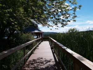
The Keuka Outlet Trail is seven miles long and follows the winding waterway where Keuka Lake flows eastward into Seneca Lake. The trail runs along an old railroad bed, has only a slight incline, and the surface is a combination of dirt, gravel, and ballast. You can find more information at www.keukaoutlettrail.org. There is also an audio tour, so bring a charged phone and you can listen to some of the history along the trail.
Meet up: We will all meet at the Cascade Falls Access Point parking area, which is right between the two waterfalls, at 3:45 pm.
Bikers: After signing in, bikers will ride to the Dresden parking area, ride the full length to Penn Yan, and return for a total 14 mile ride.
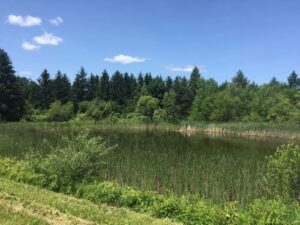
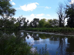
Hikers: Head east towards Cascade Mills Falls, enjoy the view of the falls and then turn around and head west towards Seneca Mills Falls. After viewing the Seneca Mills Falls, continue west to Turtle Pond. Keep heading west until it is time to turn around in order to be back at the parking area around 6:00 pm.
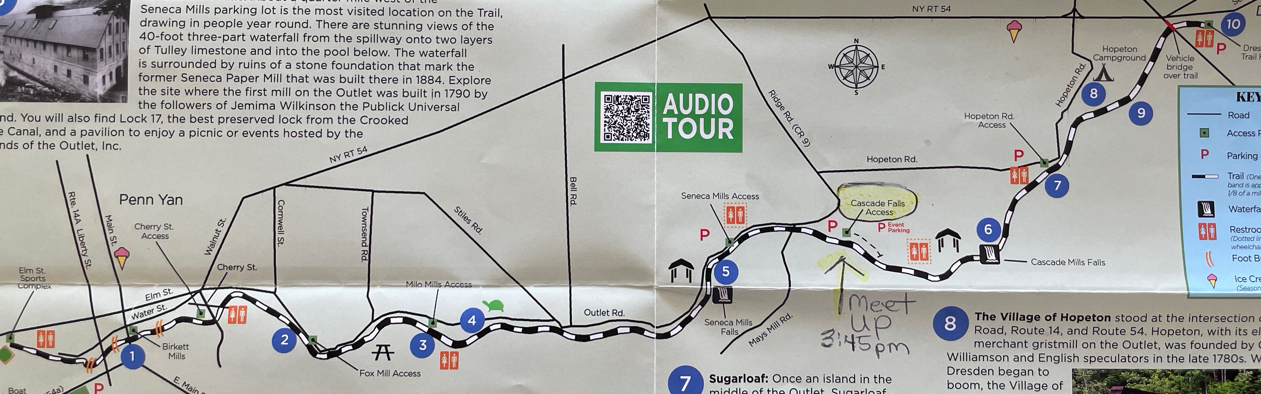
Social: The bring-a-dish social will be at the Cascade Falls Access parking area. Bring a lawn chair and a folding table if you have one. Also bring your own beverage and a dish to pass, or make a $5 donation to our social fund.
Directions from Canandaigua: Take 5 & 20 through Canandaigua, just before you reach Geneva, take 14A south to Penn Yan. Make a left onto Elm St. Sunoco Gas station on one corner and Walgreens on the other corner, Rt. 54A comes in on the right, there is no street sign here. Pick up directions below continuing on Elm St.
Directions from the south, Wayland, Dansville, Cohocton: travel north on Rt. 53 towards Naples and make a right onto Italy Valley Rd. Continue with directions below from Italy Valley Rd.
Directions from the north Honeoye, Springwater: make your way to Rt. 53 just south of Naples and turn left onto Italy Valley Rd. Continue with directions below from Italy Valley Rd.
Directions from Italy Valley Rd.: Bear right at the Y onto Italy Tpk. Rd. go to the end and make a left onto Italy Hill Road bear right past Blue Eagle Tavern. Take Italy Hill Rd. (rt. 32) past Hunt Country Vineyards to the traffic light in Branchport. Continue straight through the Branchport traffic light this is 54A. Stay on 54A which brings you right into Penn Yan and onto Elm St. Go straight through the light and pick up the directions below continuing on Elm St.
Directions from Prattsburgh: Take N. Main St to Prattsburgh Italy Hill Rd., which turns into Italy Hill Rd. (rt. 32) continue around the bend, past Hunt Country Vineyards right into Branchport. Continue straight through the Branchport traffic light this is 54A. Stay on 54A which brings you right into Penn Yan and onto Elm St. Go straight through the light and pick up the directions below continuing on Elm St.
Directions continuing on Elm St. in Penn Yan: Continue straight on Elm all the way to the end. Cornwall St. is to the left and Outlet Road is to the right. Bear right onto Outlet Road. Continue straight and you will pass Stiles Rd on your left, continue on and you will see a red barn on the right and a small parking area just past the barn, which is Seneca Mills Access. Go past this parking area and you will come to a road (Ridge Road/Mays Mills Road) on the right and will see another parking area straight ahead where we will be meeting. This is the Cascade Falls Access Point parking area.
This Sunday we will hike the Finger Lakes Trail (FLT) starting at the Mt. Morris Dam and Visitors Center Parking Lot, as well as the Wildlife Loop Trail within the Dam property. We expect to enjoy the height of summer colors and, as we follow the east rim of the Letch worth Gorge, the spectacular views of the gorge and Genesee River below.
The Wildlife Loop trail within the dam property is beautiful in its own right, with forest and grassy fields.
Three levels of hiking are planned – “Climbers”, “Tourist, and Naturalists”.
The Tourists will hike south on the yellow blazed (FLT) trail along the rim of the gorge, jogging east slightly away from the river across a boardwalk through a small wet area, stop at Hogsback Overlook to view the Hogsback formation of the river gorge, continue on the trail and after hiking 1 hour, turning around to head back. On the way back, we will follow the same yellow blazes but take the alternate orange blazed trail along the rim of the gorge which joins back up with the yellow trail, back to the parking lot. Total hike is 3.25 miles. Tourists may wish to walk the “Wildlife Loop”, once back to the parking lot.
The Naturalists may wish to walk the “Wildlife Loop” that starts to the right of the visitors center. (blue trail)
The Climbers who want a longer hike can hike from the Visitors Center following the yellow blaze Finger Lakes trail down to Lorenz Park in the village and return back on the Finger Lakes Trail. Climbers can continue along the Finger Lakes Trail south following the yellow blaze markers along gorge trail to complete the 2 hour hike.
The Hike Assembly Point:
The Visitors Center should be open with bathrooms, however, if closed, there is a bathroom adjacent to the parking lot that may be open on the day of the hike. All hikers will begin the hike at the Mt. Morris Dam Visitor Center Parking Lot. The trail access is at the west end of the parking lot (to your left as you face the gorge).
Social:
After the hike, all are welcome to gather at the larger pavilion located adjacent to the parking lot. Bring a dish to pass or a donation to the club fund would be appreciated, drink, and a chair.
Directions:
The Mt Morris Dam Visitor Center is about 45 minutes from Springwater, so please plan ahead. If you have a GPS, try entering Mt Morris Dam as your destination. Or enter Damsite Rd or 6103 Visitor Center Rd, Mt Morris.
From Springwater: Take Rt 15N and then left on Liberty Pole Rd. Stay on that road all the way to Rt63. There, take a left, and a quick right, onto Rt 258. At Rt 36, take a right and proceed to Mt. Morris. Turn left onto NY-408 South.
From Wayland: you can take I-390 north to exit 7. Turn left at the exit on NY-408 S to Mt. Morris. NY-408 goes left at Main St, then right on Chapel St.
From Hemlock and Honeoye: follow 20A West through Livonia and Lakeville to 390S. Exit at exit 7 NY 408 S to Mt Morris. Stay on 408 through Mt Morris.
From Rochester: Take I-390S to Exit 7 NY 408S. Stay on Rt 408 through Mt Morris.
From NY 408 in Mt Morris: Go south on 408 for 1.8 miles to Visitor Center Rd. Turn right at the Visitor Center Road and follow the road all the way to the Dam and Visitor Center Parking lot.
ional details about this hike are coming soon. Please check back.
Hemlock Lake and the Hemlock-Canadice State Forest remains a favorite location for Springwater Trails. This Sunday we will return to the North Boat Launch for Kayaking on the lake and Hiking on Rob’s Trail.
 All boaters and hikers will meet at the north boat launch at 3:45. Following the hike we will enjoy a pot luck social at the Hemlock Park at the north end of the lake. Boaters must bring their PFDs and hikers will want to bring walking poles.
There are four options available for this hike.
Boaters: We will unload our boats at the boat launch. It is recommended that boaters meet at 3:30 to give a bit of extra time in case the launch is crowded. Once we have a picture of all of the boaters, we will head south along the the east side of the lake. We may get as far of the Rob’s Trail beach. Adventurous boaters will then head across the lake and return to the launch along the west side of the lake.
Naturalists Hikers who prefer a level hike will head south of the old lake road. Hikers should check their watches and turn around at 5:00. That may mean turning around at the bench overlooking the lake, or possibly at the Rob’s Trail beach.
Tourists: Hikers who enjoy hiking down hill, will carpool up to the Rob’s Trail parking area on the west side of NY 15A. From there, the trail heads across fields and then enter the forest. The trail is well marked and crosses a nice bridge above a falls, and down to the lake, at which time hikers will turn right (north) and follow the old lake road. They may meet the Naturalists on the way to the boat launch.
Climbers: If any hikers would prefer to climb up to 15A, It will be easiest if they could trade keys with the Tourist drivers, and use those cars to return to the boat launch. Otherwise the Climbers will need to take a couple of cars to the top before the hike. If two climbers would like to leave their cars at the top, please call Mark at 259-4505 and we will meet you at 3:30 at the Parking lot off 15-A.
Following our hiking everyone is invited to a pavilion at Hemlock Lake Park at the north end of the lake for a pot luck social. Bring a dish to pass (or donate $5 to the social fund) and your own beverage. From the boat launch, head out to Rix Hill Rd. Take a sharp left on Rix Hill Rd and turn in at the 3rd driveway to the left. At the circle, we will find an available table for our social.
From Springwater: Head north on 15A for 10.1 miles. Turn left on Rix Hill Rd and an immediate left on East Lake Rd. Follow this road to the boat launch.
From Hemlock: Head south on 15A. At 0.7miles past the intersection with 20A, take the first right onto Rix Hill Rd into the Hemlock Lake Park. Take the first left and follow the east lake road to the boat launch.
From Honeoye: Head west on 20A toward Hemlock. At the intersection with 15A, turn left onto 15A South. In 0.7miles take the first right onto Rix Hill Rd into the Hemlock Lake Park. Take the immediate left and follow the east lake road to the boat launch.
From Penn Yan: Take 54A across the north end of Keuka Lake to Branchport. Continue straight onto Italy Hill Rd (CR32). In 4.9 miles, turn left to stay on Italy Hill Rd and take the 2nd right onto Italy Hill Turnpike (CR34). At the bottom of the hill (3 miles) stay to the left onto Italy Valley Rd (CR18). On entering Ontario County, Italy Valley Rd becomes CR21. Continue to the T and turn right onto NY 53 into Naples. Continue straight onto NY 21 North past the Wayside Market and turn left onto Clark St (CR 36). Continue for about 15 miles along Honeoye Lake. Turn left at the light onto US 20A. In 4.8 miles, turn At 0.7miles past the intersection with 20A, take the first right onto Rix Hill Rd into the Hemlock Lake Park. Take the first left and follow the east lake road to the boat launch.
Looking for brochure.or mailing list so I can receive it in the mail.
Nothing opens up for mailing list.
There’s all kinds of very bizarre ads and post for viagra and other drugs above on calender page.
Please let me know if there’s a brochure available