
Hikes led by Springwater Trails are generally held on Sunday afternoons and appear in this calendar in green.
| Sun | Mon | Tue | Wed | Thu | Fri | Sat |
|---|---|---|---|---|---|---|
| Lehigh Valley Trail Hike or Bike in Rush, NY 2:00 pm Lehigh Valley Trail Hike or Bike in Rush, NY @ Stevens-Connor Lehigh Valley Lodge Apr 6 @ 2:00 pm – 4:00 pm Come join us for a leisurely hike or bike along the Lehigh Valley Trail on Sunday April 6th! With its flat even surface, the trail is a hidden gem for walking, hiking, jogging, biking. It is a vital link in … Continue reading | ||||||
| Ontario County Park at Gannett Hill Hike-Naples 2:00 pm Ontario County Park at Gannett Hill Hike-Naples Apr 13 @ 2:00 pm – 4:00 pm  Save the date! This is one of our group favorite hikes. Ontario County Park at Gannett Hill is one of the highest points in Ontario County and located in the scenic Bristol Hills. At an elevation of 2,256 feet above … Continue reading | ||||||
| No Hike-Easter Break 2:00 pm No Hike-Easter Break Apr 20 @ 2:00 pm – 4:00 pm No hike has been scheduled for this date due to the Easter Holiday. Enjoy the break, spend time with loved ones and eat chocolate bunnies. This will give you something to burn off next week  | ||||||
| Mystery Hike-Details Coming Soon 2:00 pm Mystery Hike-Details Coming Soon Apr 27 @ 2:00 pm – 4:00 pm Mystery Hike coming your way….details under construction. Please check back. |
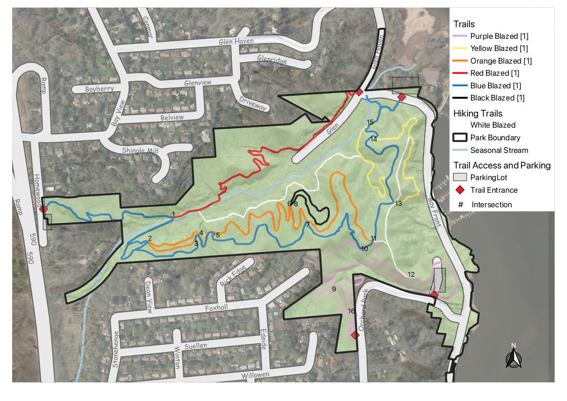 This week, our Sunday hike will offer two hikes in the Irondequoit Bay West Park and one Kayak exploration on the Bay from the Park boat launch. We last hiked this park three years ago in December. This time we are adding a Kayak option from the park’s boat launch at the south east corner of the park.
The extensive trail system in the park is mostly maintained by the Genesee Regional Off-road Cyclists and most of the trails we plan to follow are shared use trails, and all users should be aware of traffic. Cyclists are expected to yield to hikers who are hiking, but hikers who are enjoying the scenery should step aside for cyclists.. Please remember that we are enjoying the trails because cyclists have volunteered to maintain them.
Unlike hiking trails, these biking trails are only blazed at intersections, so be careful to check your trail each time you come to a crossing.
A PDF of the newest maps can be downloaded and printed. Please click on each map to the right for more details.
For this hike, we all will meet on the south east side of the park where Orchard Park Blvd ends at the Bay. If the boat launch has enough parking, we will all park right there and help Kayakers unload their boats. If necessary, hikers will be directed north along the bay to a larger parking area near the entrance to the Irondequoit Fish and Game store and across from the start of the Blue trail.
Following the hike/paddle, we will adjourn to the Tryon City Tavern for a friendly social.
The Kayaks will head south from the boat launch and follow the shore line to the mouth of the Irondequoit Creek. After entering the creek under the Empire Blvd bridge, the creek meanders through the marsh, offering many possible routes. All kayakers should stay together as they explore the creek. Plan to turn around and head back downstream to the bay before 5:15 and retrace the path from the boat launch. If boaters arrive back early, some may wish to continue north to see more of the bay.
All hikers will leave the boat launch and follow Orchard Park Blvd west to the entrance on the right into the park. From there, we will turn right and follow the purple trail uphill through intersection 12 to intersection 11.
From there, the Climbers will turn left onto the blue trail through intersections 10, 7 and 5 to intersection 4, where we will turn right onto the orange trail. At intersection 2, we will continue straight onto the blue trail. A second exit more to the left from this intersection will head back on the blue trail to intersection 4; don’t take that. After crossing the creek, at intersection 1, we will stay on the blue trail out to Homewood Rd and then return on the blue trail to intersection 1 where we will turn left onto the Red trail. The red trail ends at Glen Haven Rd, which we will follow east to an entrance to the blue trail on the right. We will stay on blue at intersection 15 and turn left at intersection 16 onto the yellow trail for a view of the bay. At intersection 13 we will go straight onto the blue trail and return to intersection 11 and turn left onto the purple trail to go out to Orchard Park Blvd. With a left turn and a walk down the Blvd, we will return to the boat launch.
At the intersection 11, the Naturalists will turn right onto the blue trail. At the next intersection, turn right onto the yellow trail that overlooks the bay. At intersection 14, turn right onto the blue trail, and then at 15 turn left onto the yellow trail. At the next intersection (un-numbered) to right onto the White hiking trail that follows the creek up to the red trail. There are two options here based on time.
- If 5:00 occurs before the end of the white trail, turn around and retrace the trail to the yellow trail, turn right on yellow, then a right turn onto the blue trail (another un-numbered intersection).
- If you arrive at the red trail before 5:00, turn right onto the red trail, which passes several old foundations and ends at Glen Haven Rd. Cross Glen Haven and the creek and turn right into the blue trail. Follow the blue trail through intersections 15, and 14
Continue through 13 on blue back to a left turn onto purple at intersection 11 to go out to Orchard Park Blvd. With a left turn and a walk down the Blvd, we will return to the boat launch.
Directions:
From Springwater: Follow NY 15A or NY 15 north to I-390. In Rochester, merge right onto I-590 N. At the intersection with 490, stay left to continue on 590N. Take exit 8 for Empire Blvd. Use the second to the right lane to turn right onto Empire Blvd. Pass through the Winton Rd intersection and take the next left onto Orchard Park Blvd. Stay to the right just off Empire Blvd and follow Orchard Park to the end (0.8 miles) at the bay. The boat launch is across Bay Front Rd slightly to the left.
From Naples: Follow NY 21 north to NY 64 in South Bristol, to US 20. Turn left on US 20, then in a mile, turn right on NY 444 to Victor. Turn left on NY 96. In 2.9 miles enter I-490. Use exit 21 for NY 590N. Take exit 8 for Empire Blvd. Use the second to the right lane to turn right onto Empire Blvd. Pass through the Winton Rd intersection and take the next left onto Orchard Park Blvd. Stay to the right just off Empire Blvd and follow Orchard Park to the end (0.8 miles) at the bay. The boat launch is across Bay Front Rd slightly to the left.
From Canandaigua: Follow NY 332N to the Thruway west. Take exit 45 for I-490. Take exit 8 for Empire Blvd. Use the second to the right lane to turn right onto Empire Blvd. Pass through the Winton Rd intersection and take the next left onto Orchard Park Blvd. Stay to the right just off Empire Blvd and follow Orchard Park to the end (0.8 miles) at the bay. The boat launch is across Bay Front Rd slightly to the left.
Directions to Tryon City Tavern ( 2300 E Main St, Rochester, NY): Return on Orchard Park Blvd. Turn right on Empire Blvd followed by a quick left (at the light) onto Winton Rd. In 1.4 miles, turn right onto Main St. In 350 feet, turn right into the strip mall. The Tavern is the first business in the strip mall.
Meet at 3:45 at the lower end of the hike, at the Italy Valley Road parking area just north of the Flint Creek crossing (42.626312, -77.281368). Everyone will set off together on the trail from here and head across the valley and uphill. Naturalists may follow a shorter trail along the edge of the valley, or follow the rest of the group and turn around after 45 minutes, Climbers/Tourists will hike to the Outback Inn shelter for a total of about 3 miles. Hiking poles will be a good idea. Make sure you bring water to stay hydrated.
Social afterwards at the Middletown Tavern in Naples, 183 South Main Street.
Directions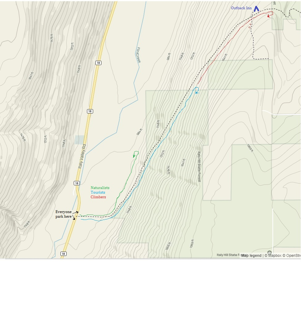 From Springwater, Wayland and Danville: Take NY-15 south to Wayland. Turn left at the light onto NY 21 N. In 6.7 miles turn left to stay on NY-21. At the stop sign in Naples, turn right on NY 53S. In 1.3 miles, turn left onto Italy Valley Rd. In 7.7 miles, near a white barn on the right, there is a trail head sign and road shoulder parking for the Bristol Hills Branch.
From Honeoye: Take CR 36 (West Lake Rd) into Naples. Turn right on S. Main St. and continue straight onto NY 53S. In 1.3 miles, turn left onto Italy Valley Rd. In 7.7 miles, near a white barn on the right, there is a trail head sign and road shoulder parking for the Bristol Hills Branch.
From Rochester, Canandaigua or points east: Take 5&20 to Reeds Corners (east of Canandaiqua) and Route 247 through Rushville to Potter, where it joins with Route 364. Just past Potter, take the first right, on Friend Road. In about .5 miles, take a right on Italy Valley Road. Go south on Italy Valley Road about 6.5 miles to the parking area just south of Flint Creek
We will explore Canadice Lake and its surrounding terrain with the travel method of your choice, starting at the Canoe Launch (the southernmost lake access point) on Canadice Lake Road (southeast corner of the lake). Meet at 3:45 and park on the road shoulder near the kiosk. If you are bringing a boat or a bike, allow extra time for unloading.
Hikers: Those interested in a gentler walk may head south along Canadice Lake Road to the southern end of the Canadice Lake Trail and follow it as long as you like, then return. The side trail through the ponds south of Canadice Lake is a nice addition to this route.
Paddlers: Put in at the south launch site and paddle the shores as far as you’d like, then return.
Cyclists: Starting at the southeast corner of Canadice Lake, head north along the Canadice Lake Road, west on Purcell Hill Road and back to the start on the Canadice Lake Trail for a total of about 7.8 miles. It that’s too short, do it twice, or extend the loop by going north to Canadice Hollow Road, adding another 2 miles to the loop. The Lake Trail is fairly level and a decent surface for road bikes with medium tires, better for hybrid or mountain bikes.
Optional Social: Bring a dish to pass or your own food and we will have a picnic at the south boat launch.
DIRECTIONS: From Springwater: Head north on 15A and cut over to Canadice Lake Road. via Wheaton Hill or Johnson Hill Road. The south access area will be on the left.
From Canandaigua, Honeoye and Hemlock: Take Route 20A to the Canadice Lake Road intersection. Go south 6.5 miles to the southernmost lake access area, on your right.
From Rochester: Take Route 390 south to the 5&20 exit, go east to Lima, then south on Route 15A. After Hemlock, turn left on Route 20A and right on Canadice Lake Road. The southernmost access area is 6.5 miles down, on your right.
Welcome to the 10th Annual Mushroom Foray [thanks to both Springwater Trails and the Rochester Area Mycological Association] at the All Western Evergreen Farm. Three hiking groups are planned, all starting and ending at the parking area at the farm. The three groups will explore much of the farm, with many opportunities to find mycological specimens.
Please plan to arrive early (1:45 PM) to sign in and to sign the RAMA liability forms.
Maps of the farm, paper bags and paper plates for collecting and displaying mushrooms will be provided. Those who want to learn how to collect mushrooms will be instructed by Gene and Georgia, and any other Rochester Area Mycological Association members who will be our guests.
The Climbers will follow the driveway up to the fields, turning to the left at the top. We will circle the pond on the southern portion of the farm and the spruce forest along the edge of the Christmas tree plantations. Heading west through the Cathedral Pines will take us to wet spots in the woods. We will return along the edge of several more Christmas tree plantations (Douglas-fir, Nordmann fir, Grand fir, Concolor fir, Canaan fir, Alaska yellow cedar, Norway Spruce, Meyer Spruce).
The Tourists will follow the driveway up through the woods, stopping occasionally to explore for mushrooms. When reaching saleable size Christmas trees (Lot Z), head to the right around or through the Christmas tree plantation. At the corner where the small Southwestern White Pine tree row ends and the tall Concolor fir are, follow the trail into the woods and back to the field and head west along the north field road to a hidden corner of the field with some spectacular 35 foot green and blue Concolor fir Christmas trees live, the size seen during Christmas season in a large mall. If there is still time, follow the north field road next to the hedge row up to Story Road. We will return through the tillable fields, visiting smaller collections of trees and back down through the woods.
The Naturalists will start exploring under and behind the Western red cedars (thuja plicata or giant arborvitae) by the parking area and south to the Alaska yellow cedar, large Concolor fir and spruce, then back up through the woods to the right of the trail up to the main fields. These are likely full of mushrooms, but you will find some swampy areas, so don’t get lost behind people’s homes along Liberty Pole.
All hikers should check their watches and return to the parking area by 4:00 PM to have their collections identified. A portapotty with a sink is nearby.
Mushroom Identification
Once again we expect to have several RAMA members with us to identify the mushrooms collected between 4 and 5 PM. After the mushrooms are identified please join us for a dish-to-pass social (5:00 – 6:30 PM) hosted by Katherine outside the house next to the Furnace Building. Please bring a lawn chair and your own beverage, plus a dish to share or a $5 contribution to the social fund.
We will begin all the hikes at 6840 Liberty Pole Road where there is ample parking at the Christmas tree loading area between the tall Western red cedar and Morton Building and Nursery beds. Follow the parking signs. When we return from our foray, the mushrooms will be displayed for identification on paper plates on the tables outdoors. Please dress for the weather, rain gear as needed. Social distancing and masks are recommended when close together.
From Springwater: Go west from the Springwater light on NY-15 North. Just past the top of the hill and after rounding the tight curve, turn left on CR 38 (Liberty Pole Road). The farm is on the left (the high side) 1.1 miles from NY-15 at 6840 Liberty Pole Road after you cross Carney Hollow Rd. There is a sign for the All Western Evergreen Nursery & Christmas Tree Farm. Follow the orange cones to the parking area and park facing the house.
From Geneseo: Go south on NY-63. About 6.4 miles after passing NY-408, turn left on CR-1 (Groveland Scottsburg Rd) at Groveland Station. This road becomes CR 1A (Springwater Scottsburg Rd) at Scottsburg (Route 256) and then Liberty Pole Road after you cross Stagecoach Road (CR 71), and finally CR-38 (still Liberty Pole Rd) after crossing Reeds Corners Rd (CR-29). It is 7.1 miles from Groveland Station to All Western Evergreen Farm. The farm is on the right (the high side). Follow the orange cones to the parking area and park facing the house.
From Honeoye: Take 20A west to Hemlock and 15A south to Springwater. Then follow the Springwater directions above.
From Rochester: Take I-390S from Rochester. Use Exit 9 for NY-15 Lakeville. Turn left onto NY-15. Stay on NY-15 for 16.5 miles, through Lakeville, Livonia, Conesus and Webster Crossing. When NY-15 curves to the left at the south end of Webster Crossing, continue straight onto CR-60 (Carney Hollow Rd) and take the first right onto Liberty Pole Rd. The farm is on the left (the high side) at 6840 Liberty Pole Rd. Follow the orange cones to the parking area and park facing the house.
If using GPS, use the map directions on the www.allwesterntrees.com website and make sure you are on Liberty Pole Road and not being directed to the center of the farm from Swartz Road or Story Road. Follow the orange cones to the parking area and park facing the house.
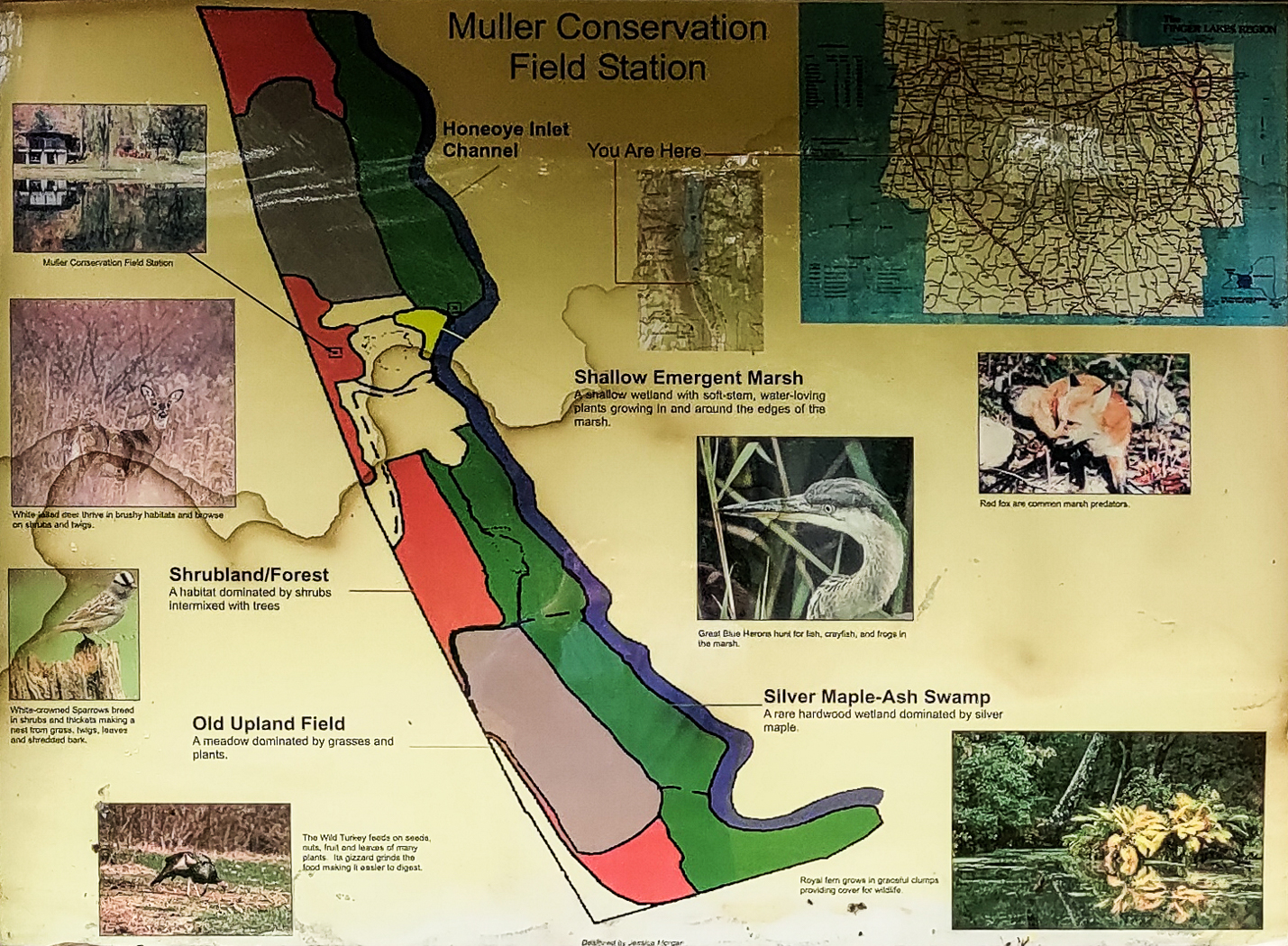
The Muller family land at the south end of Honoeye Lake is now owned by the Finger Lakes Community College (FLCC) and it has expanded into a substantial research and conservation facility. It adjoins DEC land encompassing the rest of the south end of Honoeye Lake, and the FLCC and DEC have restored the water flow through the property and into the lake to salvage the ecology of the area. Springwater Trails has permission to kayak the inlet stream and to hike along it too.
We will do both on Sunday September 17th, 2023. Meet and park in the lot at 1:45 at the Muller Field Station, 6455 County Road 36, Honeoye for a 2pm hike/paddle start. Come earlier if you want to use one of the Field Station’s boats, which are first come first served.
Beavers have done their work to adjust the property to their liking, and signs of beaver activity are plentiful. Tall invasive grasses dominate the trail borders and seasonal wildflowers are plentiful. Snakes are common and harmless to humans.
The hikers will follow the single trail following the inlet south in an out-and-back hike with each group turning back when they feel they should. The site director, Ally Esposito, will accompany the hikers and talk about the flora, fauna and the ecology of the property. There is a gate separating FLCC land from DEC land that can be walked around.The trail on FLCC land is mowed, but the DEC land tends to be more wild but sill very passable. In principle the trail goes all the way around the south end of the lake to the south boat launch on the east side but this hasn’t been tested yet.
The Muller Field Station and the Honoeye Inlet
The kayakers will put in at the luxurious boat launch close to the station complex. They will explore the inlet south as far as a very low bridge that effectively blocks passage by water, and will then turn back to see what’s downstream as far as the lake proper.
The FLCC has kayaks and canoes that are available to be borrowed; Please bring your own PFD if you want to take advantage of this.
Directions:
We will all meet at the Muller Field Station, 6455 Co Rd 36, Honeoye, NY 14471
From Rochester: Take Rt. 65 south to West Bloomfield, then crossing Rt. 20 take Rt. 37 south to Honoeye. At the junction with Rt. 20A turn left, then right at the lights in Honoeye on to Rt. 36 which is West Lake Road. Continue south on Rt. 36 for 5.6 miles; the Muller Field Station is through some imposing gates on the left side of the road. The gates are recessed and angled to the south so they are easy to miss from the north.
From Springwater: Take Rt. 15A south to Wayland, then turn left on to Rt. 21 to Naples. In Naples turn left (north) at the Middletown Tavern on to Rt. 36, also called Hunt Hollow Road. Continue north on Rt. 36 for 10 miles; the Muller Field Station is through some imposing gates on the right side of the road.
By GPS: Program in (42.71266, -77.51203) and follow directions.
The Social
The social will be a pot luck picnic at the Muller Field Station.
Directions: The Field Station is at #6455 on the east side of County Road 36, a.k.a West Lake Road in Honeoye. From Honeoye, it’s 5.8 miles south from the traffic light at Route 20A in Honeoye. From Naples, it’s 9 miles north from Main Street; turn at the Middletown Tavern.
We will start from the trailhead on Bean Station Road, meeting at 1:45 for a 2 PM start. Following the orange blazes, we will head south past the restored Covell Cemetery and the Evangeline Shelter then climb steadily uphill through a hemlock and oak woods to the state forest and onto the top of the plateau. Tourists and Naturalists will go as far as the bog observation deck and then back track to Bean Station Road (~3miles total). Climbers will continue on past the overlook and follow the Bog Nature Trail Loop clockwise returning to Bean Station Road by way of the blue blazed side trail and then the main trail (~4.5 miles total).
Directions to Meeting Location
From Springwater: Head south on NY 15 to Wayland. Turn left onto NY 21, Turn left in N Cohocton to stay on 21 into Naples. Turn right onto NY- 53. Stay on NY-53 through Prattsburgh. Follow the directions below.
From Prattsburgh, take NY- 53 South for 2.6 miles to Bean Station Road. Turn east on Bean Station Road at the site of a large white warehouse for onions. Go 2.6 miles to the yellow trailhead sign on the right (south) side of the road at a little footbridge over the roadside ditch. Park on the north side of the road – this is important as this is a narrow road and parking on both sides could cause a traffic hazard.
From Geneseo and Dansville: Take I-390 South to I-86East. In 1 mile, take exit 37 for NY-53. Turn left onto NY-53 and head north for 8.9 miles. Turn right onto Bean Station Road. Continue with the directions From Prattsburgh.
This Sunday we will return to the Genesee Valley Greenway (GVG) for a bike or hike on a section of the trail that is farther north than we have hiked in the past. We will meet close to the northern border of Livingston County with Monroe County.
Notice:
The Hometown Event published in Friday’s PennySaver was a week early. This Sunday we will be hiking the Greenway. Join us next week, October 8th, 2023, for a hike on Rob’s Trail in Hemlock.
 All hikers and bikers will meet at 1:45 (for a 2:00 start) at the Lehigh Valley Trail parking area on West River Rd between Avon and Scottsville. This parking area is across the street from the Livingston Office Park located at 96 W River Rd and just a few feet north of the River Road Transfer Station driveway..
The Tourist/Climber hikers who would like a three mile or more flat hike will carpool 2.4 miles north to Canawaugus Park in Scottsville. From that parking area, we will find the GVG at the east end of the parking area and turn right to head back south to the Wadsworth Junction with the Lehigh Valley Trail. A left turn will take us across the Genesee River. Based on available time, the group will hike as far as time permits along the Lehigh Valley Trail timing things to return to the GVG at about 3:45, allowing 15 minutes for the final half mile on the Lehigh Valley Trail back to the cars.
Meanwhile, the Naturalists and any other hikers who would prefer an out and back hike will follow the Lehigh Valley Trail east to the GVG at the Wadsworth Junction. From there, we will head north of the GVG. After an hour (or when we meet the Tourist/Climbers group), we will turn around and return to the cars.
Finally, the bikers (who should arrive around 1:45 to unload their bikes) will head east on the Lehigh Valley Trail. At the Wadsworth Junction, we will turn left onto the GVG and ride north through the Canawaugus Park. We will regroup at the NY-253 crossing to evaluate our route back to the cars. The map above shows a route east on 253 for a mile to a right turn into Harrogate Crossing. We will explore the neighborhood (turn left on Longton Pl, left on Westcombe Park and right on Martin Rd) to get to East River Rd. We will pass the New York Museum of Transportation and continue past NY 251 until we come to the Lehigh Valley Trail. From there it is 2 miles to the cars for a total ride of 11 miles. My pre-ride took 1 1/4 hours (an average of 9.2 mph). I expect we will spend a bit more time enjoying the scenery.
This trail is currently in excellent condition. The initial segment of the Lehigh Valley Trail has some erosion as it slopes down. Bikers should take this slowly to avoid getting caught in the erosion. The main Greenway headed north is crushed stone which is very smooth. Occasional walnuts on the trail and stop signs at tractor crossing will keep bikers alert. The bikers will ride on NY-253 with wide shoulders and E River Rd with good shoulders until we cross NY 251. There is one railroad crossing on 253 where all bikers will want to cross perpendicular to the tracks. The more narrow shoulders on E River Rd after 251 will require us to share the lane with the occasional car. Finally, the Lehigh Valley Trail from E River Rd to the Wadsworth Junction is level dirt, only slightly rougher than the crushed stone.
Social: Following the ride and hike, we will gather for a social at the Mortalis Brewing Company.
Directions to the trailhead:
From Springwater: Take NY-15A north to Lima. Turn left on 5 & 20. You will cross I-390, and NY-15, go around the circle in Avon, and cross the Genesee River. Stay straight on NY-5 when US-20 turns to the left. You will cross the Greenway and then turn right onto CR 84 (W River Rd). In 4.3 miles, the parking area will be on the right.
Alternatively from Springwater: Take NY-15 north for 22 miles through Livonia and Lakeville. Turn left onto 5&20, staying on NY-5 when US-20 turns left after Avon. You will cross the Greenway and then turn right onto CR 84 (W River Rd). In 4.3 miles, the parking area will be on the right.
From Dansville: Take I-390 north for 29 miles to exit 10. Turn left onto 5&20, staying on NY-5 when US-20 turns left after Avon. You will cross the Greenway and then turn right onto CR 84 (W River Rd). In 4.3 miles, the parking area will be on the right.
From Naples: Take CR 36 north for 14 miles to Honeoye. Turn left on US-20A for 4.8 miles Hemlock. Turn north on NY-15A to Lima. Turn left onto 5&20, staying on NY-5 when US-20 turns left after Avon. You will cross the Greenway and then turn right onto CR 84 (W River Rd). In 4.3 miles, the parking area will be on the right.
From Canandaigua: Take 5&20 west for 25 miles, staying on NY-5 when US-20 turns left after Avon. You will cross the Greenway and then turn right onto CR 84 (W River Rd). In 4.3 miles, the parking area will be on the right. (Google maps says you can save 2 minutes by going north and taking the Thruway).
Notice: Sunday, Oct 8, 2023: The weather forecast seems to be consistently predicting rain and wind peaking at 3:00. So, check for updates before you head out today. We will hike if there is no lightning and there are hikers dressed for rain, but hikes may get shortened based on the weather. Also note the change to the social below. If you don’t come today, we will be at the the Folk Art Guild in Middlesex next week if the weather improves. Also note the change to the social below.
Rob’s Trail offers a peak opportunity for Finger Lakes hiking – a delightful woods walk from one Finger Lake to another. The full 8-mile walk is longer than our usual SWT event, so we’re planning separate start times and places for those wishing to do the full lake-to-lake distance, with shorter and easier hikes available to the Tourist and Naturalist groups.
For Climbers – lake to lake hike: meet at 12:45 for 1PM start at the Hemlock Lake north boat launch. 42.742059, -77.608443 We will hike for about 2.5 miles along the Hemlock lake shore, then climb to the Route 15A crossing and over the ridge on the loop trail, with a snack and rest break at the mid-point. We will descend on the Canadice side of Rob’s Trail and return to the Purcell Hill Road trailhead for carpooling back to the start. Estimated time is 3.25 hours. If you are seeking a possible bail-out in the middle, contact Saralinda through Comments section and we can arrange for an escape plan at Route 15A. Poles and rain gear are recommended, as showers are predicted and the ground will be slippery from earlier rains.
For Tourists and Naturalists – Canadice Lake Trail and Rob’s Trail to the Loop: meet at 1:45 at Purcell Hill Road trailhead for 2PM start. 42.743197, -77.574363 Tourists will hike 1.75 miles to the Rob’s Trail intersection and up to the ridge, around the loop trail, and back to the start the same way. Total distance about 4 miles with some moderately steep sections. Poles and rain gear are recommended, as showers are predicted and the ground may be slippery from earlier rains. Naturalists will follow along with the Tourists until the Rob’s Trail intersection, but remain along the Canadice Lake Trail as far as you want and return. All relatively level terrain, good wide trail surface.
Social – Join us for refreshments afterwards at the Valley Inn, 8790 Main Street, Honeoye (corner of Route 20A and County Road 37.
Directions – to Hemlock Lake North Boat Launch (for Climbers only, at 12:45 PM) – From Springwater: proceed north on Route 15A 19 miles, then make a left on Rix Hill Road and an immediate left on Old East Lake Road, a.k.a Boat Launch Road. From Honeoye and points east: Take Route 20A west from the Bristol Valley and Honeoye. When 20A meets Route 15A, make a left and go about .6 miles to Rix Hill Road. Make a right and then an immediate left on the boat launch road. From Rochester and points west: Take Route 15 south from Henrietta or Route 15A south from Honeoye Falls, or Route 390 south to the Lakeville-Livonia exit, then go south on Route 15 and then east on Route 20A through Hemlock. When Route 20A turns east toward Honeoye, go straight another .6 miles and make a right on Rix Hill Road. Then make an immediate left onto the boat launch road and go to the end, 1 mile.
Directions – to Canadice Lake Trail (for Tourists and Naturalists, at 1:45PM) From north: Route 20 between Honeoye and Hemlock, go south on Canadice Lake Road and west on Purcell Hill Road. The Canadice Lake Trailhead will be on your left. From south: From Springwater, go north on Route 15A to Johnson Road, make a right and then a left on Canadice Lake Road. Pass the lake and make a left on Purcell Hill Road. The trailhead parking area will be on your left.
Directions to Valley Inn for Social – From Purcell Hill Road, return to Canadice Lake Road and go north to Route 20A and east toward Honeoye. The Valley Inn is on your left at the intersection with County Road 37.
Sunday October15 we will visit East Hill Farm, home of the Rochester Folk Art Guild, to enjoy their annual Apple Festival and a hike across their 350-acre hilltop farm and woodlot. The Guild is a community of craftspeople, producing fine quality handmade products in wood, pottery, fabrics, paper, toys, books and more. We will have an opportunity to visit their artisan workshops and Gallery Shop before or after the hike – for more information about the Guild and the Festival see
https://www.folkartguild.org/events/open-house-and-apple-festival/
Please arrive by 1:45 for hiking starting at 2 PM. Park on the road shoulder at 1445 Upper Hill Road, Middlesex (directions below). We will convene at the side of the East Hill Gallery, the first building on the left as you come in the driveway.
Climbers will head south through the Guild’s farm and neighboring properties, past a pond and sauna, through a spruce grove, and looping through woods and mowed fields to the Golden Valley, named for its spectacular fall color and views to the east across Italy Valley. We will return through the woods and pass an eclectic array of residential buildings, workplaces and gathering places, designed and built by community members over their 50 years of occupancy at the East Hill Farm. Total distance is about 3.5 miles. Tourists and Naturalists will make a shorter loop of about 2 miles. Trails are gently sloped and well cleared. As a hunting season precaution, please bring some bright colored outerwear, along with water, poles and dampproof boots. With showers possible, good rain gear is also advised (as we learned last Sunday).
Social: We will convene after the hike for a bring-your-own social on the grounds of the Guild’s main farmhouse, or inside. Homemade cider, local apples, lunch dishes and desserts will be on sale throughout the festival (11-5) or until everything runs out.
Directions: from Springwater/Naples: Take Route 15 south to Wayland and Route 21 east/north to Naples. Turn right on Route 245 opposite Bob’s and Ruth’s Restaurant, at the north end of the village. Follow Route 245 north to Middlesex, about 8.75 miles. Turn right on Route 364 and go up the hill, one mile. Turn right on Upper Hill Road and go 1.5 miles. East Hill Farm will be on your left, at #1445. Park on the road shoulder and walk in the driveway to the Gallery building, the white house on your left.
From points north: Head to Routes 5 and 20 via Bloomfield or Canandaigua. At the east edge of the City of Canandaigua (first light after Wegmans/Post Office), turn south on Route NYS Route 364 (a.k.a. East Lake Road). Follow Route 364 south 12.5 miles to Middlesex, where 364 turns to the east and you will make a left onto Route 245 and then an immediate right to continue on 364. Go up the hill, one mile. Turn right on Upper Hill Road and go 1.5 miles. East Hill Farm will be on your left, at #1445. Park on the road shoulder and walk in the driveway to the Gallery building, the white house on your left.
The Sunday hike on October 22nd 2023 we will walk the FLT on Hatch Hill in Naples; the Fall colors should still be strong for this hike. The hike will start at the Bob North bridge at the bottom of Ontario Street in Naples. There is a kiosk and a small parking lot there, and all groups will start at the same place. The Naturalists will walk along Matt’s Meander to the Naples Community Park and back, while the Tourist will walk south along Hatch Hill above the town to the south end of Naples. The Climbers will walk north on Hatch Hill to Conklin Gully. Both Tourists and Naturalists will walk back to the parking lot, while climbers will end up at the DEC parking area at the bottom of Conklin Gully and be shuttled back to Naples. Note: the last half mile of this hike is a very steep downhill, but it’s worth it; there are huge drops into the gully to the right of the trail, and wonderful view across the gully and down into it.
There is a DEC display board at the parking lot with a map of all the trails that meet there; all the day’s hiking trails are shown.
Naturalists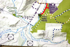

The Naturalists will cross Naples Creek on the Bob North bridge and bear to the left. It is a broad path through woods with the Naples Creek flowing to the left of the path. This trail is called “Matt’s Meander”, and it follows Naples Creek to the Community Park on Route 245. It is about a mile to the end of the trail and back.
Tourists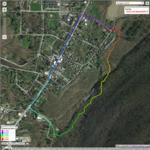

The tourists will cross the bridge and bear to the right. The trail runs south along Hatch Hill above Naples Creek, and goes parallel to both Naples Creek and Naples Main Street, though a lot higher up the hill. This path is not blazed or marked at all but it is well trodden for most of the way; it becomes a little harder to see at the southern end, but once the Turkey Federation parking lot is in sight then it’s not hard to find a way down to it. The trail passes through land that was once grazed and then terraced for vines, but is now returning to woodland. Traces of the shallow terracing for the vineyards can be seen all along the trail, and occasionally an abandoned farm building. The creek can be seen in the valley below the trail all the way along. This trail ends at the south end of Naples, on Mark Circle, where several streams come together to form the Naples Creek. There is water supply facility there, a swimming hole, and an antiques shop. The group will return to the Ontario Street parking lot via Naples Main Street. This walk is 2.1 miles. with just one short modestly steep section.
Climbers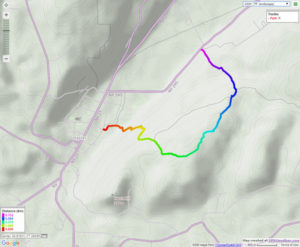
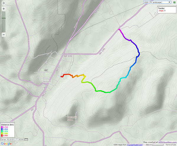
The Climbers will take the Finger Lakes Trail to Conklin Gully through the High Tor Game Management Area. They will cross the bridge and bear left along with the naturalists, and then about half way down Matt’s Meander the FLT branches off to the right. The group will follow the ORANGE blazes on a long uphill section; it’s steep in places with some switchbacks – the trail seems to be going the wrong way at times. There are some ponds at the top of the hill (it’s a mystery – where does that water come from?) with the Howard Beye memorial bench on one of them. It’s important to stay with the orange blazes here – there are several logging roads that make it easy to take the wrong path. Where the trail meets the top of Conklin Gully there is a lookout with a fine view of the Naples Valley and a well organized scout camp, complete with fire pit. The path down the hill from the camp is broad and easy walking. The group will leave the FLT where it branches off to the right over a bridge to the memory of Tom Noteware and follow the BLUE blazes down the hill to the DEC parking lot at the bottom of Parrish Hill.
The Meeting Place
We will meet at the trail head parking lot on Ontario Street, Naples, at 2:00pm. The climbers will shuttle some cars to Parrish Hill before starting off.
Getting There
From Springwater and Wayland, come south on Rt. 15 to the traffic light at Rt 21. Turn left on 21 and keep going all the way to Naples. Go through the downtown business area and turn right on Ontario Street, opposite the school. Go to the bottom of the hill and the parking lot is on the left.
From Dansville, follow Rt. 63 to Wayland where the road turns into Rt 21; continue on 21 all the way to Naples. Go through the downtown business area and turn right on Ontario Street, opposite the school. Go to the bottom of the hill and the parking lot is on the left.
From Naples, go to the school on Main Street (Rt. 21). Turn down Ontario Street opposite the school, go to the bottom of the hill and the parking lot is on the left.
The Social
The social will take place at the Middletown Tavern, 183 S main Street in Naples
.
Looking for brochure.or mailing list so I can receive it in the mail.
Nothing opens up for mailing list.
There’s all kinds of very bizarre ads and post for viagra and other drugs above on calender page.
Please let me know if there’s a brochure available