
Hikes led by Springwater Trails are generally held on Sunday afternoons and appear in this calendar in green.
| Sun | Mon | Tue | Wed | Thu | Fri | Sat |
|---|---|---|---|---|---|---|
| Lehigh Valley Trail Hike or Bike in Rush, NY 2:00 pm Lehigh Valley Trail Hike or Bike in Rush, NY @ Stevens-Connor Lehigh Valley Lodge Apr 6 @ 2:00 pm – 4:00 pm Come join us for a leisurely hike or bike along the Lehigh Valley Trail on Sunday April 6th! With its flat even surface, the trail is a hidden gem for walking, hiking, jogging, biking. It is a vital link in … Continue reading | ||||||
| Ontario County Park at Gannett Hill Hike-Naples 2:00 pm Ontario County Park at Gannett Hill Hike-Naples @ Lookout Parking area Apr 13 @ 2:00 pm – 4:00 pm  This is one of our group’s favorite hikes! Ontario County Park at Gannett Hill is one of the highest points in Ontario County and located in the scenic Bristol Hills. At an elevation of 2,256 feet above sea level, you’ll … Continue reading | ||||||
| No Hike-Easter Break 2:00 pm No Hike-Easter Break Apr 20 @ 2:00 pm – 4:00 pm No hike has been scheduled for this date due to the Easter Holiday. Enjoy the break, spend time with loved ones and eat chocolate bunnies. This will give you something to burn off next week  | ||||||
| Rob’s Trail – Hemlock Lake side 2:00 pm Rob’s Trail – Hemlock Lake side Apr 27 @ 2:00 pm – 4:00 pm Join us on Sunday April 27 to hike the west side of Rob’s Trail, the DEC/Nature Conservancy property in the northeast corner of Hemlock Lake. Options are to hike out and back to the south along the trail from the … Continue reading |
It is June and sunny and warm. What better way to spend a Sunday afternoon than on Hemlock Lake? Bring you kayak or hiking shoes and meet Springwater Trails at the North End boat launch on Hemlock Lake. We will enjoy the water or Rob’s Trail and then will meet after the hike (and kayak) at Hemlock Lake Park for a pot luck social. Bring a dish to pass and your own beverages or donate to the social fund.
Kayak or Canoe Paddle
Boaters will meet at Hemlock Lake North Boat Launch and must arrive early enough to have their boat unloaded and car parked in preparation for a 4PM launch. Try to arrive at 3:30 because the launch will likely be crowded. They will cross the lake to the western shore, paddle south, cross the lake to the eastern shore and return north to the boat launch. Paddlers will need to determine how far south they can go and have enough time to get back to the launch by 6PM.
Hikers
All hikers will meet at the large parking area of Hemlock Lake Park off Rix Hill Road at 4PM. All hikers will walk south past the gate on the flat part of Rob’s trail.
The Tourists and Climbers will walk south through the woods until Rob’s Trail heads uphill. Before turning up the hill, we will step out onto the beach and check on the progress of the kayakers. Then this group will continue up the hill to the bridge (or as time permits) and then will return down hill and back to the cars.
The Naturalists will follow the climbers but likely will turn around at or before the beach and return along the same path to the cars.
All hikers and kayakers are welcome to join us for a social at the Hemlock Park pavilion. Head north out of the boat launch to Rix Hill Rd. Turn left and take the second left into the pavilion..
Directions to Hemlock Lake North Boat Launch
From Springwater: Head north on 15A for 10.1 miles. Turn left on Rix Hill Road. Take the first left and follow the road to the end at the boat launch. If the main boat launch is not crowded, we will launch kayaks from there. Otherwise, we can park in the parking lot or along the road and carry kayaks to the kayak launch site.
From Hemlock and Honeoye: From Hemlock head south on 15A. From Honeoye, head west on 20A and turn left onto 15A. From the intersection of 20A and 15A south of Hemlock, continue south for 0.7 miles and turn right onto Rix Hill Rd. Take the first left and follow the road to the end at the boat launch. Parking is available in the lot at the end, or along the road.
Warning: The weather report calls for rain this afternoon and possibly thunder storms. We will be at the trailhead by 4 and will ride if the weather permits. If it looks like thunder we likely will postpone to another day and just have a beer. Stay safe and keep hiking.
This Sunday we have a choice of activities, both starting from the northeast corner of Honeoye Lake – a hike in Sandy Bottom Park or a bike ride along or around Honeoye Lake. Note the start time of 4 PM for both activities. After the workouts we will adjourn to the Birdhouse Brewing Company at 8716 Main Street, Honeoye for our social/recuperation.
Everyone meets at the Sandy Bottom Park Trailhead on East Lake Road, about .3 mile from Route 20A/Main Street Honeoye. There are two parking lots side-by-side, each holding about 10 cars. Hikers will all start out together on the field portion of the trail and proceed as long as you want, with some hiking all the way down to the creek, lakefront and wetland boardwalk.
Based on last year’s experience, most cyclists will opt for the full 18 mile circuit of the lake, all going at our own speeds. We’ll decide as a group whether to go clockwise or counterclockwise. An alternative for those who want a shorter ride is the 5 mile dash down East Lake Road to the South Boat Launch, returning the same way for a 10 mile total.
Cyclists please bring plenty of water, and helmets are required.
Social: Please join us afterwards at the BirdHouse Brewing Company at 8713 Main Street, Honeoye, for restorative food and beverages and maybe some entertainment. For the menu see https://birdhousebrewing.beer/
Directions to Sandy Bottom Trailhead:
From the south (Naples, Springwater, etc): Take Rte 21 North to CR 36, make left onto CR 36, make right onto East Lake Road – parking lot is on left just past the County Road 33 intersection.
From the north (Bloomfield, Victor, Rochester, etc): Take CR 40 south to Rte 20A, cross 20A onto East Lake Road, parking lot is on right, 3/10 of a mile from intersection.
From the east (Bristol, Canandaigua, etc): Take Rte 64 south to Rte 20A, make right onto 20A, left onto East Lake Rd
From the west (Hemlock, Livonia, etc): Take Rte 15A to Route 20A, make left onto 20A, right onto East Lake Road
Directions to Birdhouse Brewing Company: From the trailhead, return to Route 20A, Main Street Honeoye. Make a left and proceed through the village. Birdhouse Brewing is at #8713, just past the bridge on the right, a few buildings before the red light.
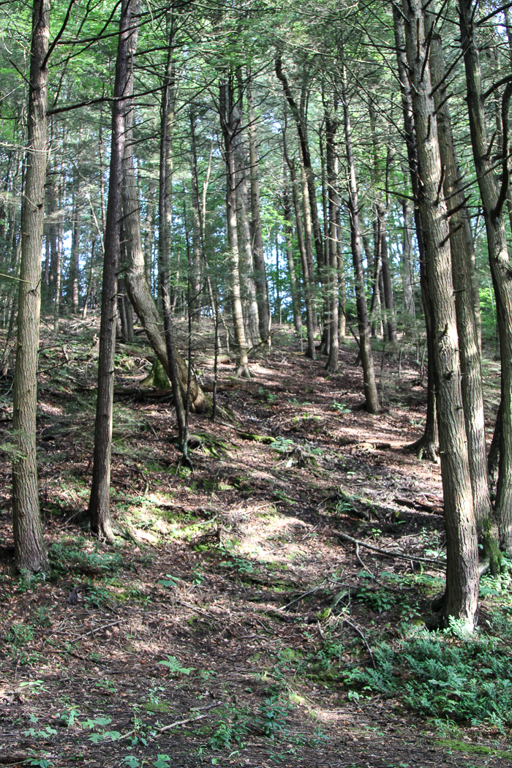
This Sunday, we will have the opportunity to enjoy the unique arboretum at Durand-Eastman Park. Included in their rhododendron collection, are a few trees called mountain laurels, which are common in the Appalachian hills. The mountain laurel is in bloom at this time. It has a unique trick for getting bees to transfer their pollen, which we will attempt to demonstrate. When we tried last year, we were too early. This year, our timing looks better.
We will meet in the circle at the end of Log Cabin Rd. at 3:45 PM. We will then hike the trail, at the south end of the park, to the junction of Zoo and Pine Valley Rds., enter the arboretum at Pine Valley, and walk to the mountain laurels for the attempted demonstration. Afterwards, hikers seeking a more vigorous walk are welcome to enjoy some of the park’s nice hiking trails and return to the Log Cabin Rd. Circle at 6 for our after-hike social.
There are 4 shelters in this area so, in case one of them is unoccupied, perhaps we can appropriate it. If not, we’ll just use the lawn (and hope it isn’t raining). Bring a food item to share or make a $5.00 donation. Also bring lawn chairs. I have a folding table but, we might be able to use more, if you have and would like to bring one.
Mark will bring a small portable grill, in case anyone wants to grill something.
Directions:
From the Springwater area, go north to I-390. In Monroe Co., use the right lanes to get on I-590. At junction with 490, stay on 590. Get in middle lane, avoid 104 exits, and stay left to go toward Sea Breeze. At the fourth roundabout (you’ll see a bunch of flags), go ¾ of the way around and keep going straight west on Durand Blvd, which turns into Sweet Fern Road, and then Pine Valley Rd and then (at Zoo Rd) into Lakeshore Blvd. DO NOT turn on Zoo Rd, or you will have to walk from Zoo Rd to Log Cabin Rd because that section of Log Cabin Rd is closed to cars. Instead, take the next left on Log Cabin Rd. (past Zoo Road), go to the circle at the end and park in the circle.
Hikers wishing to carpool from Springwater should meet at 2:30 at the Springwater Town Hall and plan to leave promptly at 2:40. Be sure to ask the driver if they are staying for the social. This is a self organizing car pool, so be sure to be on time.
From Naples or Canandaigua, head north to the Thruway and I-490 west. Stay right to exit onto 590 north. Get in middle lane, avoid 104 exits, and stay left to go toward Sea Breeze. At the fourth roundabout (you’ll see a bunch of flags), go ¾ of the way around and keep going straight west on Durand Blvd, which turns into Sweet Fern Road, and then Pine Valley Rd and then (at Zoo Rd) into Lakeshore Blvd. DO NOT turn on Zoo Rd, or you will have to walk from Zoo Rd to Log Cabin Rd because that section of Log Cabin Rd is closed to cars. Instead, take the next left on Log Cabin Rd. (past Zoo Road), go to the circle at the end and park in the circle.
From Honeoye, there are several ways to get to 590 north. Google maps is suggesting Clover St to Monroe Ave and then get on I-590, but it depends on traffic. So I am going to leave it to each driver to find their way to I-590 or I-490 and then follow the directions above.
Finally, Happy Father’s Day to all my fellow dads.
The Kayaking today is CANCELLED! The weather is threatening. We will still hike if the storms haven’t reached the pier in Canandaigua yet
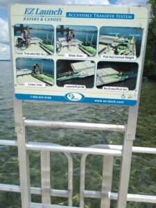
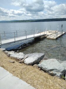
Kayak or Hike Canandaigua Lake Sunday June 26 from 4-6PM. Paddlers will launch from Ontario County Beach Park on East Lake Road while walkers will gather at the city Pier for a self-guided stroll. Boat launch is free with plenty of parking and no portaging needed. Boaters will travel south on the east side of the lake passing by Deep Run Park, the historic Thendara restaurant and Boathouse which are now part of a Mcmansion housing development, and numerous other stately beach homes. After passing Crystal Beach Park, if time permits, we will continue further south where 364 and East Lake Road split and there are some of the small older cottages visible along the lakeshore.
Hikers will walk a 3-mile loop starting from the City Pier, where the boathouses are,then head up to Lakeshore Drive, turn right and head into Kershaw Park and follow the trail along the lake. At Twisted Rail head back up to the road and cross over to Lagoon Park which has a figure 8 loop; there are several board maps in the park. Retrace your steps back to the pier.
SOCIAL will be at Twisted Rail.
DIRECTIONS FOR BOATERS: Ontario County Beach Park is located on the right side of East Lake Road aka Rte 364 and is 2.7 miles south of the intersection of 364 and Lakeshore Drive. If coming from the south it’s on your left, just under a mile north of Deep Run Park and the intersection of CR 1.
DIRECTIONS FOR WALKERS: At intersection of Rte 332 aka South Main Street, 5&20, and Lakeshore Drive turn right onto Lakeshore Drive bearing right and park at the Pier. If coming from the east turn left at the intersection.
NOTE: This Sunday’s hike was originally planned as a hike/Kayak event. However, due to Harmful Algal Blooms on both lakes, we have adapted to a hike/social event only.
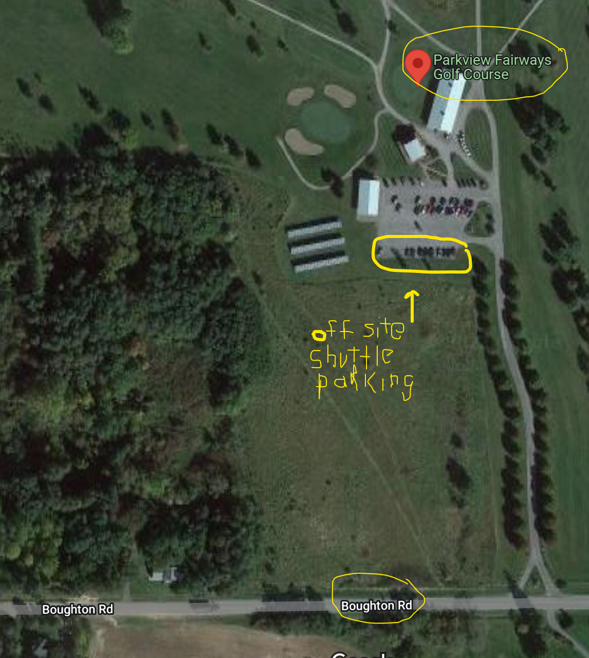
NOTE #2: Due to limited parking for guests at Boughton Park, please RSVP to reserve a parking permit. Offsite parking is available with a shuttle if RSVPs exceed our permits.
Boughton Park is located in the northern part of the Town of East Bloomfield, Ontario County. From the 1920s to the 1980s Fairport used the two reservoirs at this location for their water supply. We will have three hikes around these old reservoirs (now often referred to as “ponds”). The trails are good with very mild elevation changes. There is poison ivy beside the trails. If you stick to the trails you are okay, but be sure you can identify it if you get off trail. It is often just beside the trails, but not on them.
Carpooling: Parking (by permit only) is available at the trail head, but we are limited to 16 parking permits. If you plan to come, please RSVP to reserve a parking spot. Let Renee know if you plan to carpool.
NOTE #3: If you are unable to RSVP prior to the Sunday hike, please arrive fifteen minutes early to allow time to park at the offsite location. If no permits a still available, we will arrange with you to park offsite and be shuttled back to the Park. See the map at the end of this post.
Please plan to carpool, to preserve both gas and parking spots. Unsupervised carpools will start from the Springwater Town Hall or from the Sandy Bottom parking area at the north end of Honeoye Lake. Plan to arrive at Sandy Bottom at 3:15 to leave promptly at 3:25 for the hike. Or meet at the Springwater Town Hall at 3:00 to leave promptly at 3:10. Or, you may call and plan your own carpool. If you plan to
 Hike Meet Location: All hikers will meet at the Stirnie Road parking lot. Please park at the Stirnie Road entrance, where the pavilion is located. We will have parking permits when you arrive – so please be on time! For clarity there is another parking lot off Boughton Rd, which we are NOT using as our “hike meet location”.
Optional After-Hike Social: We are planning a social at the pavilion near the parking. Please bring a dish to pass and your own beverage. Or bring your own sandwich if you prefer to not share, or make a donation to the social fund.
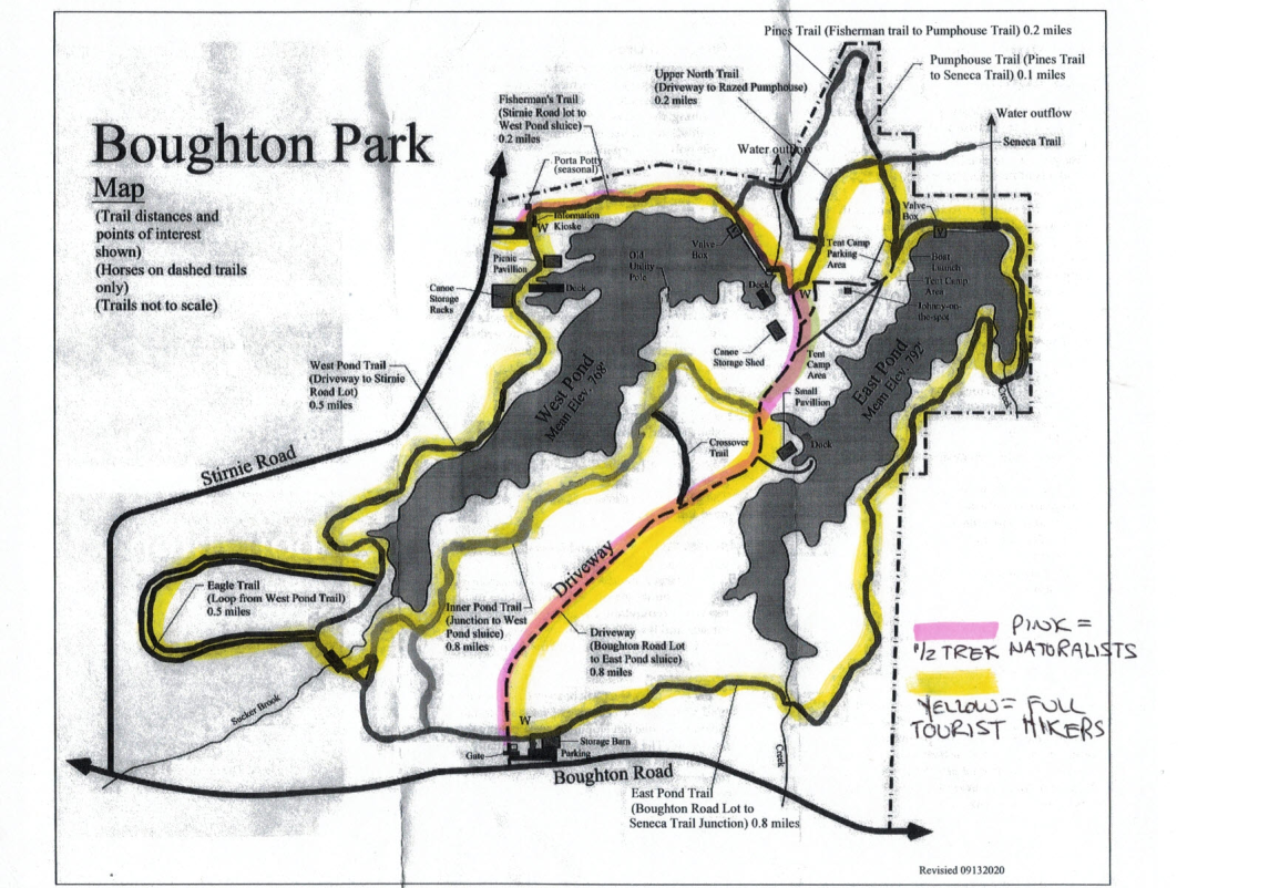 Hike Plans: Boughton Park consists of 330 acres and 5 miles of designated trails. The area has some rolling hills with perhaps 50-100 foot max elevation change. The park is reserved for residents of Victor, East Bloomfield and West Bloomfield and their guests. On Sunday, Springwater Trails will be guests. For more information, click on the Boughton Park link.
The Victor Hiking Trails Seneca Trail connects to the north end of Boughton Park and from there, you can hike all the way through Victor to Perinton and the Crescent Trail.
Hike Routes: For a larger map, click on the map or check the board at the trailhead.
Climbers and tourists: Renee will lead one group around both ponds, (including a new loop at the southwest corner), then north along the west pond, to the east pond, and south along the east side of this pond, followed by the gravel road back to the north end, and along the west pond back to the pavilion, this is about 4 miles.
Naturalists: Saralinda will lead the naturalists north to views of the west pond, then on the gravel road to the east pond and to the Boughton Road parking lot and then back to the pavilion, 1 mile total.
Directions: To carpool locations
Springwater Town Hall: Please be at the Springwater Town Hall at 1:00PM to carpool to Boughton Park. Click here for directions to the town hall. Remember, this is an unsupervised carpool and drivers will be leaving promptly at 3:10PM.
Sandy Bottom: If Honeoye is more convenient, please meet at Sandy Bottom at 3:15PM to carpool. Drivers should leave promptly at 3:25PM.
Directions: TO THE HIKE: Set your GPS to (42.937581, -77.441284) or to 1911 Stirnie Rd (parking is on the east side of the road).
From Honeoye and the Sandy Bottom Park (carpool location) :
– From Sandy Bottom, head north on West Lake Rd.
– Take Rt 20A east for 5.9 miles
– Turn left onto CR 2 for 1 mile, then continue straight onto Oakmount Rd (CR2 turns right).
– Turn left onto Rts 5&20 and travel 1 mile.
– Turn right onto NY-64
– In a half mile, turn right onto Eddy Rd.
– Take the first left onto CR 39 and continue onto CR 39 for 1.7 miles.
– Turn right onto Boughton Rd (CR 39 will continue to the left)
– Take the first left onto Stirnie Rd. The parking area is 0.8 miles ahead on the right. (past a curve to the right, and a curve to the left)
From Springwater and the Town Hall (carpool location):
–Take Rt 15A north from the flashing light in Springwater.
–Turn right onto Rt 20A toward Honeoye. After 4.0 miles
– Turn left on CR 37 to go north to West Bloomfield.
– Turn right onto Rts 5&20 east at the West Bloomfield Congregational Church.
– In 3.7 miles, turn left onto Cannan Rd, (its the first road that crosses US20 both left and right).
– Cross NY64 where the road becomes Bennett Rd.
– At the first road, turn right onto CR 39.
– At the right hand curve on CR39, take a slight left onto Boughton Rd
– Take the first left onto Stirnie Rd. (It’s a VERY VERY short travel on Boughton Rd) The parking area is 0.8 miles ahead on the right. (past a curve to the right, and a curve to the left)
From Rochester area:
– Take I490 East to the Victor Exit 29.
– Merge onto Rt 96 S into Victor.
– Turn right onto Maple Ave (Rt 444) (follow the sign to Bristol Mt).
– At the flashing light turn right onto Boughton Hill Rd (CR 41) (At Ganondagan)
– Take the 1st left onto Murray Rd.
– At the T, turn right onto Town Line Rd.
– Take the 1st left onto Stirnie Rd. The parking is on the left after 0.4 miles.
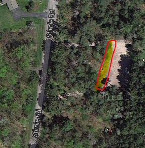
Off Site Parking
We have arranged for permission for hikers to park at Parkview Fairways. See the map below and be sure to park in the indicated location to avoid interference with Fairway customers. If you have not RSVPed, please come to Stimie Rd parking lot for specific directions to the Parkview lot.
 This Sunday we’ll return to an old favorite, a walk in the woods at the Wesley Hill Preserve in Canadice/South Bristol, with a social afterwards at the Birdhouse Brewery in Honeoye.
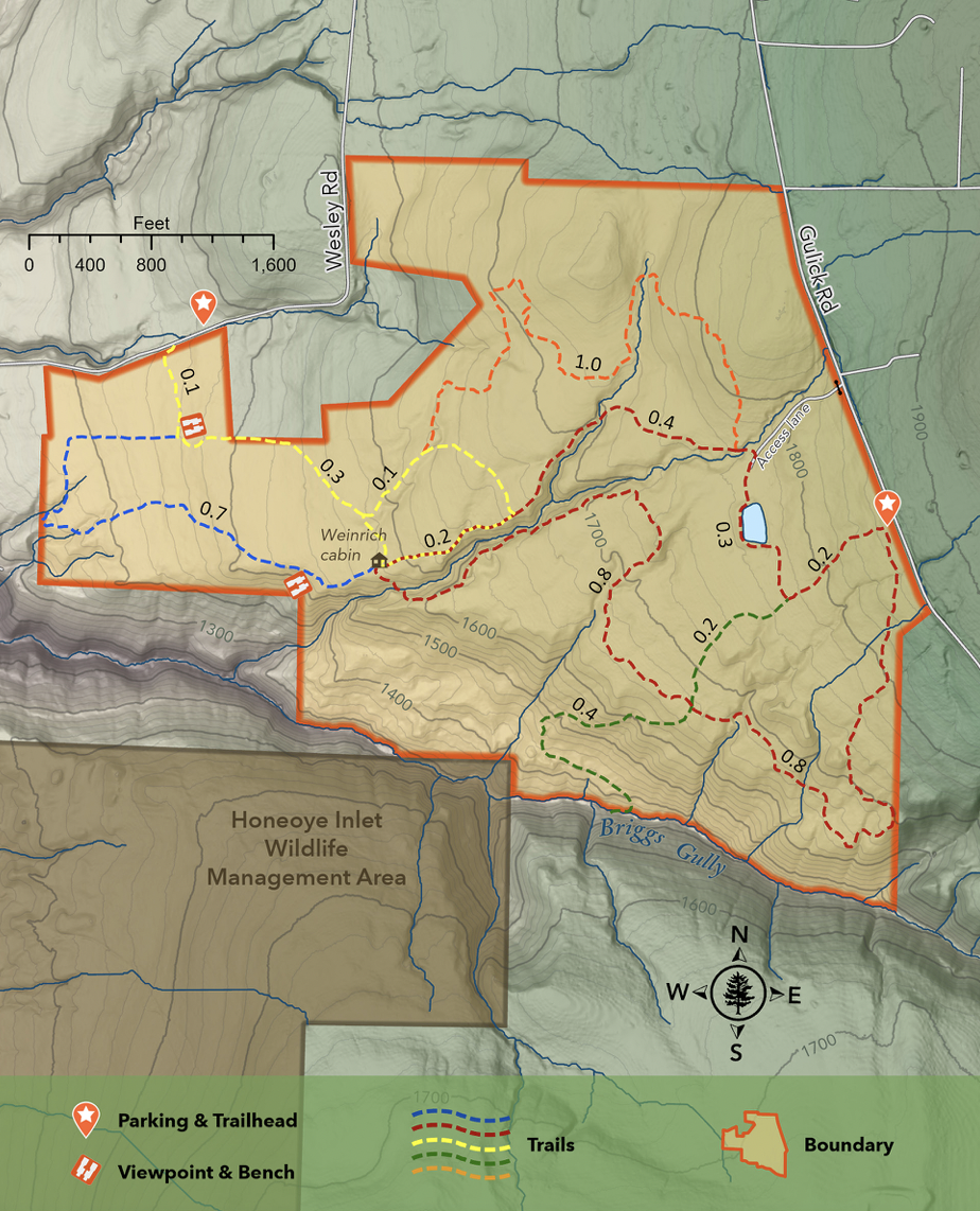
Meet at the Wesley Road parking area at 3:45 for a 4pm start. The Climbers will make the full perimeter loop of the property on the Yellow, Blue, Red and Orange Trails for a total of about 5 miles. The Tourists and Naturalists will follow a shorter loop of around 3 miles. The weather is expected to be warm, but the woods should keep us comfortable and we’ll adjust the hike lengths as the weather dictates and stop for an occasional frolic in the stream. Bring plenty of water.
Wesley Hill is a Finger Lakes Land Trust property of 390 acres on the hill east of Honeoye Lake. including stands of northern hardwoods, red and white pines, hemlocks, a woodland pond, and the northern edge of Briggs Gully, as well as the Wenrich Cabin, set in an old forest overlooking the gully, deep in the woods. The preserve was established in 1999 by the generous donation of 90 acres by the children of three artists – John Wenrich, James Havens and Colburn Dugan – to the Finger Lakes Land Trust. Since that time, the Land Trust has expanded Wesley Hill through the purchase or donation of four additional parcels. For more on the Preserve, see fllt.org/preserves/wesley-hill-nature-preserve/
Following the hike, our social will be at Birdhouse Brewing, 8716 Main Street, Honeoye.
DIRECTIONS: From Honeoye: take route 20A east through Honeoye to East Lake Road (CR 33). Turn right onto East Lake Road. (If coming from Bristol or points east, it’s a left onto East Lake Road). Take the first left, staying on CR 33, then the first right onto Pinewood Hill which becomes Gulick Road. Once on Gulick Road, travel about 2.5 miles to a right on Wesley Road, then another mile to the Wesley Road parking lot, on your right.
From Springwater: Take your favorite route to Naples and proceed north on County Road 36 toward Honeoye. In 1.5 miles, make a right on Gulick Road, then a left on Wesley Road after about 8 miles (pass Camp Cutler and Cumming Nature Center). Go one mile down the hill to the Wesley Road parking lot and trailhead.
Directions to the Social from the trailhead:
Via East Lake Road: Turn right out of the parking area on Wesley Road. Go down the hill about 1 mile to East Lake Road and make a right. Go north about 4.5 miles to Route 20A, and make a left. Birdhouse Brewing is on your right, just over the bridge and before the traffic light.
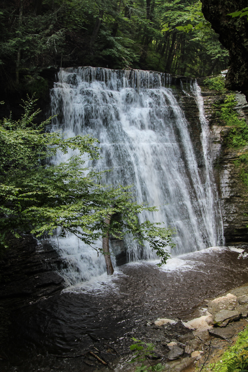
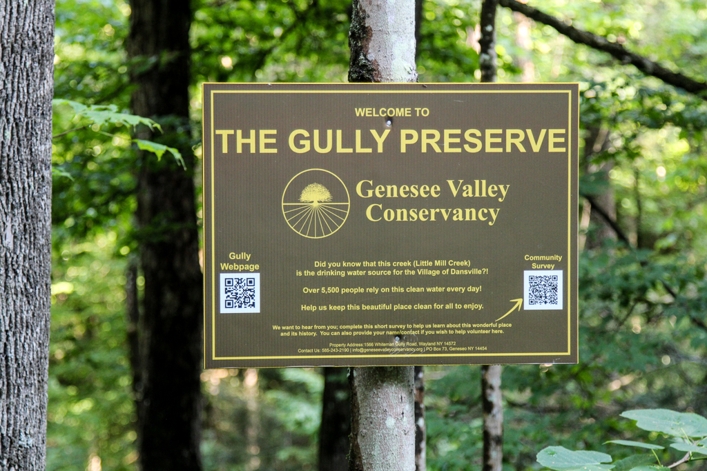
Whiteman Gully is a unique place – a pristine Finger Lakes gully untouched by any organized hand. It was privately held until recently, when it was bequeathed to the Genesee Valley Nature Conservancy.
This is a different hike to our usual long walk; it will be a hike of exploration along trails which are not long, but unimproved and requiring care. There are potentially 3 trails to explore, only one of which has been pre-hiked. The Conservancy web site speaks of “waterfalls” – plural – but only one has been seen so far. There have been no “improvements” to suit casual walkers on this property; if there has been rain recently the paths will be muddy but the waterfalls and the stream more impressive. To get a good view of the one waterfall that has been seen there is a stream crossing on stepping stones to be dealt with, and the section of the trail to get a view of the waterfall is short but steep; this pattern is likely to be repeated on other trails that we explore.
The gully does not appear to have been farmed or logged and the trees are big and old.
The Meeting Place
We will meet at the point where Whiteman Gully Road in Wayland crosses the stream of the gully (42.55731, -77.65159). There is adequate roadside parking on Whiteman Gully Road. First we will explore the trail to the north west and the gully around the waterfall. We will then return to the meeting point and explore the trail upstream and finally the trail the the north west on the opposite side of the stream to the first trail that we followed.
All hikers will walk in just one group on this hike, and hiking alone is definitely to be avoided given the uncertainty of the trail conditions.
Equipment
Gum boots or high waterproof boots and two walking poles are strongly recommended for the stream crossing, especially if there has been rain, and the poles are generally helpful on muddy and steep ground.
We will bring a rope to help on the steep section of the trail near the waterfall
Directions:
From Naples: Come into Wayland on Rt 21 from the east. Continue through the two traffic lights when the road becomes Rt. 63 to Dansville. Passing the the Wayland school on the left, continue for about 3 miles to Whiteman Gully Road on the right. Turn right and follow the road for about half a mile; the road turns into dirt and drops downhill; the gully is at the bottom of the hill where the stream is marked by barriers along the side of the bridge.
From Springwater: Come into Wayland on Rt 15 and turn west on to Rt. 21, then follow the directions as from Naples.
From Dansville: Drive towards Wayland on Rt 63 and take the second Whiteman Gully Road left – Whiteman Gully Road follows an arc with both ends on Rt. 63 – then follow the road for about half a mile. The road turns into dirt and drops downhill; the gully is at the bottom of the hill where the stream is marked by barriers along the side of the bridge.
The Social
The social will be at the Sunset Family Restaurant in Wayland, NY.
Next Sunday’s hike will take us to this Wildlife Management area run by the DEC Division of Fish and Wildlife for the purposes of conservation and recreation. A “tor” is by definition a hill or mound, therefore not much flatland for hikers. However, I have done my best to accommodate our 3 levels of hikers for this outing.
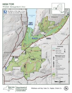
Meeting Place
Large parking area on Basset Rd. Naples. From Rt. 21 in Naples, heading south, bear left on Rt. 53.. In about .75 miles, turn left on County Rd. 21. aka Italy Valley Rd. Basset Rd is a left turn, about 2 miles east. The parking area is on the left, about .5 miles down.
Hiking Groups
All hikes are on shaded gravel forest roads which lead from the same point in the parking area.
Naturalists and Tourists will head north on the gravel road, soon passing through a gate. They will bear left and pass by two nice ponds, then head uphill on a gradual grade through the woods. The Naturalists can choose to turn around and return to the start at any point, as needed. After about 1 mile another gate is reached and the Orange Bristol Hills Branch of the FLT appears ahead, still on the gravel road. In about .5 miles the orange trail veers left into the woods, but hikers continue straight ahead on the truck trail. In a short distance the DEC lean to and overlook towards Canandaigua Lake appears. Unfortunately the view is limited by trees, but it is a good place to sit and rest for a bit. The return route is back down the same road for a total of 3 miles.
Climbers will take the road to the right after the gate and begin to ascend through the woods for about 1 mile. Eventually the road levels out quite nicely. Another gate is reached at which point the group will turn left and enjoy a nice downhill for about 1 mile to a lovely pond on the right. There is path along the shore if a closer look is desired. The gravel road continues uphill straight ahead to a gate at the intersection with the Orange trail. A right turn on the Orange trail followed by a straight ahead on the DEC road will bring the group to the lean to and overlook. Return route will be down hill via the gravel truck trail back to the parking area. Total trip is about 5 miles.
Social
Following the hike we will meet at Middletown Tavern on the corner of Main Street (Rt 21) and Clark St. (Co.Rd 36).
Looking for brochure.or mailing list so I can receive it in the mail.
Nothing opens up for mailing list.
There’s all kinds of very bizarre ads and post for viagra and other drugs above on calender page.
Please let me know if there’s a brochure available