
Hikes led by Springwater Trails are generally held on Sunday afternoons and appear in this calendar in green.
| Sun | Mon | Tue | Wed | Thu | Fri | Sat |
|---|---|---|---|---|---|---|
| Lehigh Valley Trail Hike or Bike in Rush, NY 2:00 pm Lehigh Valley Trail Hike or Bike in Rush, NY @ Stevens-Connor Lehigh Valley Lodge Apr 6 @ 2:00 pm – 4:00 pm Come join us for a leisurely hike or bike along the Lehigh Valley Trail on Sunday April 6th! With its flat even surface, the trail is a hidden gem for walking, hiking, jogging, biking. It is a vital link in … Continue reading | ||||||
| Ontario County Park at Gannett Hill Hike-Naples 2:00 pm Ontario County Park at Gannett Hill Hike-Naples @ Lookout Parking area Apr 13 @ 2:00 pm – 4:00 pm  This is one of our group’s favorite hikes! Ontario County Park at Gannett Hill is one of the highest points in Ontario County and located in the scenic Bristol Hills. At an elevation of 2,256 feet above sea level, you’ll … Continue reading | ||||||
| No Hike-Easter Break 2:00 pm No Hike-Easter Break Apr 20 @ 2:00 pm – 4:00 pm No hike has been scheduled for this date due to the Easter Holiday. Enjoy the break, spend time with loved ones and eat chocolate bunnies. This will give you something to burn off next week  | ||||||
| Hike Rob’s Trail – Hemlock Lake side 2:00 pm Hike Rob’s Trail – Hemlock Lake side Apr 27 @ 2:00 pm – 4:00 pm Join us on Sunday April 27th to hike the west side of Rob’s Trail, the DEC/Nature Conservancy property in the northeast corner of Hemlock Lake! Options are to hike out and back to the south along the trail from the … Continue reading |
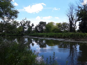
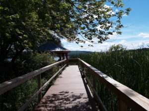
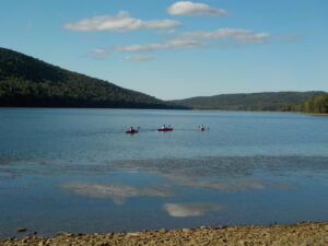
Please join us for kayaking on Sugar Creek and Keuka Lake or a hike through the marsh preserve to the lake. Our starting point will be the Finger Lakes Museum site, accessible from Guyanoga Road or from Route 54, both close to the flashing light at the center of Branchport. The Finger Lakes Museum is a former elementary school which is being gradually converted to a regional museum. They have an active boat launch site at the rear bordering Sugar Creek, the main tributary into the west branch of Keuka Lake.
Checking the weather, expect a very warm day with scattered showers.
Kayakers should arrive by 3:40 to unload your boat and launch from their floating dock. Hikers, who will follow the trail along the river, and kayakers will leave at 4:00.
After launching, kayakers will head upstream in Sugar Creek through a woodland waterway. Based on time and conditions we then will turn around and head back past the dock to the lake. Once on the lake we will start heading west and enter the adjacent marshland owned by the Isaak Walton League. Cattails, water lilies and waterfowl are abundant in the marsh waterways. Back on the lake we will continue west to the marinas of Branchport. Another U-turn will take us toward Keuka Lake State Park. Finally, we will return to the river and up to the takeout at the Museum’s dock.
Hikers will hike to Keuka Lake along the museum paths, stopping at an observation platform overlooking the marsh and at the Museum’s lakefront pavilion.: After enjoying the lake views, we will return to the museum and explore the museum grounds.

Social: Bring your own snack or a dish to pass at the Museum’s pavilion. Or contribute $5 to the social fund and snack from the dishes available.
Directions:
From Springwater and Wayland – Take Route 15 south and then Route 21 north to Naples. Coming into Naples, go right on Route 53 toward Prattsburgh. In 1.2 miles make a left on Italy Valley Road. You will remain on Italy Valley Road for about 8.7 miles, although the county road number changes from 21 to 18 to 34 en route. At the end of Italy Valley Road, go left for .3 miles on Italy Hill Road (CR 35), then follow Itlaly Hill Road as it curves to the right and becomes CR32. In another 4.7 miles you will be at the flashing light in the center of Branchport. Go straight on Route 54A toward Penn Yan for .2 miles, and turn left into the Finger Lakes Museum across from the Library, and before the Fire Station. Look for the driveway toward the new barn on your right.
From Canandaigua and 5&20: Take East Lake Road south to County Road 1, or Route 247 from Reed’s Corners into Rushville. Continue South through Rushville toward Penn Yan. Route 247 will become Route 364 shortly before Potter. Continue for 4.5 miles past Potter and make a right on Guyanoga Road (CR 29). Go another 6.5 miles to Branchport. Turn left into the Finger Lakes Museum at 3369 Guyanoga Road, or if you miss it, go left at the flashing light and then left into the FLM drive. If you come in from Guyanoga Road, go to the right around the building and parking lot, and follow the signs to the Creekside Center (a new barn). Park on the grass near the boat rack. If you take the side entrance in from Route 54A heading east toward Penn Yan, turn in to the left, across from the library, and then right into the Creekside Center.
Sorry all, but the weather really isn’t cooperating. We are going to cancel today. Please come down to the Community days if it is drier after noon and stay out of the lightning.
This coming Sunday is Springwater Community Day at Canute Park off School St in Springwater NY. Festivities start early with an egg and pancake breakfast. Events will include an antique Car Show, and the Tractor Pull. You are all invited to stop by the park and enjoy the festivities. Be sure to stop by the Floyd Ingraham’s Springwater book launch between 9 and 3 and meet the author Julie Manwarren. She will be able to tell you the history of the photos by Springwater resident Floyd Ingraham taken in the first decades of the 20th century, and how the original negatives were processed to create some of the best pictures you will find of rural life at that time. She may even personally sign a book for you.
One other event on that day is a rummage sale at the Springwater/Webster Crossing Historical Society Museum, 8130 Route 15, Springwater, NY 14560. The museum will be open and all proceeds from the rummage sale will benefit the Historical Society.
Following the Community Day festivities, Springwater Trails will lead a hike on the Wheaton Hill trails. All hikers will start on the Pine Trail where we will walk through woods to one of the typical gullies of the Finger Lakes. After this loop we will cross the road to the Spruce Trail through a spruce plantation likely planted 50 or more years ago. The Climbers will break off to check out the Redbud Trail for additional exercise.
 Following the hike, if the weather holds, hang around for our post hike social. You can share your copy of Julie’s book and enjoy the outdoors. Bring a chair so you can relax. Also, if you haven’t eaten too much at the Community Day festivities, bring a sandwich and beverage and maybe a small snack to share with the group.
This Sunday we will be kayaking and hiking Canadice lake. Kayakers and hikers will meet at the south kayak launch . Kayakers should plan on arriving 15-20 minutes early for a timely launch at 4:00pm. hikers can walk from here to the south trail entrance and enter the west lake hiking trail. The west lake hiking trail starts at the south end of the lake and continues along the lake for four miles arriving at the north gate. Hikers can hike as long as they wish before turning back enjoying the wild flowers and lake views along the way. Kayakers will head in a direction favorable to wind direction determined at the time of launch.
We will meet back at the south kayak launch for a “after hike” social. Bring a sandwich or dish to pass and something to drink.
Directions:
From Rochester: Take Rt 15A ((East Henrietta Rd) south toward Hemlock. Continue through Hemlock on 15 A south four about 4 miles and turn left on to Parselle Road. Drive for a mile and turn right on Canadice Road. Drive south on Canadice Road for about 3 miles. Don’t stop at the first boat launch. Continue down the lake to the kayak launch. There is a Kiosk on the right hand side. Park along the road and walk down the trail (100ft) to the lake. Unload your kayak at the kiosk and find a place to park along the road.
From Naples, Wayland and points south, Head to Wayland and turn on to Rt 15 north. Continue straight through Springwater on Rt 15A for 1.5 miles and turn right on Wheaton hill Rd. Continue up the hill for 1 mile and turn left on to Canadice Rd. Continue on Canadice Rd. for about 2-3 miles. you should see Canadice lake on your left. the Kiosk will be on your left along the Rd. unload your kayak at the kiosk and find a place to park along the side of the road.
Join us on Sunday at the Finger Lakes Boat Museum. In 1996 a small group of dedicated antique boating enthusiasts, motivated in part by a common concern over the rapidly dwindling population of locally-built wooden boats, committed to establishing a museum that would preserve the boating heritage of the Finger Lakes Region of New York State. The museum founders, all active in the “antique boat world,” felt that a museum focusing on the impact that recreational and commercial boating had on the development of the lakes and tourism in the Finger Lakes Region would increase appreciation and awareness as well as help preserve these vintage craft.
The Museum Collection has now grown to more than 200 boats built by many of the 40+ commercial builders identified to date as having built boats throughout the Finger Lakes Region during the last century.
The museum currently has three floors of the historic former Taylor Wine Company’s main building to explore with several exhibit spaces and a new wing renovated in 2015. Visitors can see canoes, rowboats, row outboards, outboard runabouts, inboards, hydroplanes, and sailboats. Many related artifacts and ephemera are also on display, including a 130′ x 10′ lake and nature mural and replica lake cottage. A 60′ x 10′ lake mural was also recently completed in the Inboard Motor Boat exhibit room. Our main building also contains an active boat shop where visitors are able to see restoration projects underway.
We all plan to meet at the museum at 3:00 for an hour or so to check out the boats. You should feel free to come earlier if you expect to spend more time. If the museum is not of interest, join us for a hike to start promply at 4:30.
After exploring the Boat Museum, head south on Pleasant Valley Road (County Road 88) about .8 miles to the Urbana Town Hall at 8014 Pleasant Valley Road ( 42.389558, -77.260007 ). We will gather between 4:15 and 4:30 for a 4:30 start. The trail will take us through a vineyard, over a bridge, along a former rail line, and up along the south rim of Mitchellsville Creek, a very pleasant climb through a hemlock and pine forest with frequent views to the deep gully below. Mushrooms and tiny toads abound. The full hike (Climbers) is 4.8 miles (total out and back) and about 2 hours; Tourists and Naturalists can head back to the start whenever so inclined. The path is well marked and cleared, though on the steep side in a few places.
After the hike, please join us for the social at the Pleasant Valley Inn, just a few hundred feet south from the Town Hall parking lot. Bear right at the intersection onto Fish Hatchery Road and then enter the first driveway on the left, between two white posts – this is the back way into the Inn, which is pink and white. The main entrance is at 7979 Route 54. Please let us know ASAP if you plan to join us at the Pub, so we can let the Inn know we are coming.
1. Bring hiking poles if you want to hike up Rob’s trail. It could be very slippery.
3. Bring a chair for the social after
4. Check the weather and this website for rain related changes to the plans.
Be safe and stay dry.
 the northwest corner of Canadice Lake, at the Purcell Hill Road trailhead. It’s only a short distance up the hill from the intersection of Canadice Lake Road and Purcell Hill Road. Tourists and Naturalists can walk as far as they want along the lake shore, up to 6.5 miles if you go all the way to the south end, and return. If you have any questions about the kayak paddle or the hike location you can call Jim on (585) 880-0188
Climbers who would like more of a challenge can head up Rob’s Trail toward Route 15A.We’ll be working out this hike as we go because of the weather conditions this week – there has been a huge amount of rain, so if the conditions on Rob’s Trail are excessively muddy or slippery we’ll just turn around. This will be a there-and-back hike, and at it’s longest it adds up to almost 6 miles, with half of it easy level walking by the shore of the lake; the questionable part is when we leave the lakeshore and find the steep slopes at the beginning of Rob’s Trail.
Directions to Hike:
From Springwater: Head north on 15A and make a right on Purcell Hill Road. The trailhead will be on your right in 1.2 miles.
From Canandaigua, Honeoye and Hemlock: Take Route 20A to the Canadice Lake Road intersection. Go south 3.4 miles to the Purcell Hill intersection. Turn right and go .4 miles. The trailhead will be on your left.
From Rochester: Take Route 390 south to the 5&20 exit, go east to Lima, then south on Route 15A. After Hemlock, turn left on Route 20A and right on Canadice Lake Road for 3.4 miles. Turn right on Purcell Hill Road and go .4 miles. The trailhead will be on your left.
CANCELED – Due to thunderstorms predicted for 3:00 today, our hike is canceled.
This Sunday we will return to Keuka Lake for a hike through the State Park and a bike ride across the top of the land between the Y and back along the West Bluff Rd. Following the bike/hike we will all meet in the park picnic area to relax and socialize. Bring your own beverage and sandwich and perhaps a snack to pass.
The park has a $7 day use fee so we will all meet at the parking lot at the Finger Lakes Museum and then car pool into the park. See the directions below.
The bike ride is about two and a half hours long, so we will meet an hour early at 3:00 to allow for the extra time. Bicyclists may want to carpool back to their cars prior to the social – we don’t think there is a fee after 5:00.

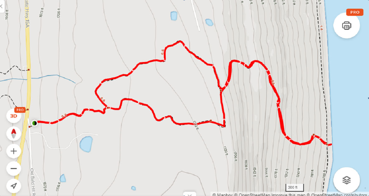
Click map for a printable version.
Hikers: The White Trail starts across the main road from the Picnic Parking area. All hikers will head up the white trail past an historic cemetery. This trail starts steep but it seems that all hikers will be able to regroup at the cemetery. From there, the trail continues up through woods to Campground Rd. Turn right onto the road, the left at the Tee and continue up to the end of the road (about a quarter mile). The Green Trail continues straight from the end of the road. At the first trail intersection, turn left to head back down toward the campground. There is a second intersection, but hikers will continue straight. The Green Trail comes out into the Twin Fawns campsite circle at site 76. Turn left on the road and head down to campsite 66 to join the purple trail under the large willow tree. Please be respectful of campers if the sites are in use.

Click on map for a full size image.
Just a few feet down the purple trail, turn right onto the yellow trail. This trail follows a gully down to the lower parking area. At our prehike, the day after the big rain, the stream at the bottom of the gully was beautiful. The original parking is about half a mile up the road, or hikers can follow the shoreline back to the picnic area. This hike is slightly less than 4 miles.
Bikers: Our bikers will head uphill, out of the park to Pepper Rd. Turning right on Pepper Rd will take us along the edge of the park. We will continue past W Bluff Rd to the tee at Skyline Dr. Again, turn right and continue the climb to the open fields at the top with some nice views of the lake. Our total climb is 700 ft over 6 miles. Skyline Dr will turn left as we pass the Seasonal Road sign and head down hill. We will stop at the Garrett Memorial Chapel. Continuing down Skyline Dr, we will turn right on W Bluff Dr. By the time we reach the cottages on the lake, we will have descended 700 ft in 1.2 miles (check your brakes before you start!). The final 5.5 miles along the shore line is a relaxing drive by many nice cottages. At the north end we will stay to the left, go around the gate and continue back to the cars in the park.
 Directions: The following directions are to the meeting spot up by the brick museum building on the west side of the grounds.
From Springwater, (Wayland and Naples): take NY 15 south to Wayland. Turn left on NY 21 N through N. Cohocton to Naples. Turn right on NY 53 south. Turn Left on Italy Valley Rd (CR 21). Turn right onto Italy Hill Turnpike (CR 34). At the top, turn left onto Italy Hill Rd (CR 32) and follow that road to Branchport. Continue straight onto NY 54A and take the first left onto School St. Stay to the left up the hill, in front of the old school building and around to the left to the first parking lot.
From Canandaigua: There are many equally good ways to get to Branchport from Canandaigua. Here are the simplest directions I could find. Head east on 5&20. Turn right onto NY 247S. In 6 miles, at the intersection with NY 245, bear left toward NY 245N, but then turn right to cross 245 onto Blodgett Rd. In 5.2 miles, turn left onto NY 364. In 4.5 miles, turn riht onto Guyonoga Rd (CR 29). Continue into Branchport. Turn left onto NY 54A and take the first left onto School St. Stay to the left up the hill, in front of the old school building and around to the left to the first parking lot.
Directions from the Museum to the Park: Follow School St back out to 54A. Turn left and follow 54A past Esperanza Mansion on the left to Pepper Rd. Turn right on Pepper Rd, then the next right into the park. The day-use fee is paid at the entrance. Then turn right toward the lake and beaches. We will park at the second parking lot near the picnic area.
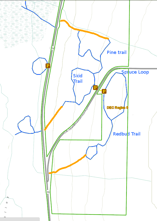
CHANGE OF PLAN – The proposed bike ride has been postponed because of questionable weather and hazardous road conditions, as several roads on the intended route have had oil and stone applied this week. Please join us for the Wheaton Hill hike, which will proceed as planned. NOTE THE START TIME OF 3 PM FOR THE HIKE.
Hikers will meet at 3 PM at the Wheaton Hill Road trailhead, on the northwest side of the road and will divide into groups for a Climber hike and a Tourist/Naturalist hike. As usual, bring water, good footwear and poles if you use them. The trails are rugged in places. Long pants are advised.
Social: After completing the hike around 4:30 to 5:00 please join us for a dish-to-pass social at the United Methodist Church in Webster Crossing church (see directions below). Bring your own beverage and favorite goodies. Dishes, utensils, condiments etc will be provided. Or just bring a beverage and a $5 donation and help yourself to snacks. A bathroom, kitchen, fridge and dining room are available for our use.
DIRECTIONS TO HIKE START: Trailheads for Wheaton Hill trails are a half mile up from the west end of Wheaton Hill Road where it meets Route 15A in Springwater, just past the south end of Hemlock Lake.
From the north, go to Hemlock, then proceed south on Route 15A. About a mile and a half past the South Hemlock Boat Launch, turn left on Wheaton Hill Road. Proceed a half mile up the hill and park on the road shoulder near the curve.
From the south, go north on Route 15 to Springwater, continuing straight at the light. Make a right on Wheaton Hill Road in about .9 miles. Proceed a half mile up the hill and park on the road shoulder near the curve.
DIRECTIONS TO THE SOCIAL: From the end of the hike go west on Wheaton Hill Road and then south on Route 15A into Springwater. At the light, make a right onto Route 15 North. Go up the long hill to Webster Crossing, about 4.6 miles. The United Methodist Church will be on your left at #7230, opposite the beginning of May Road. Park at the rear of the building.
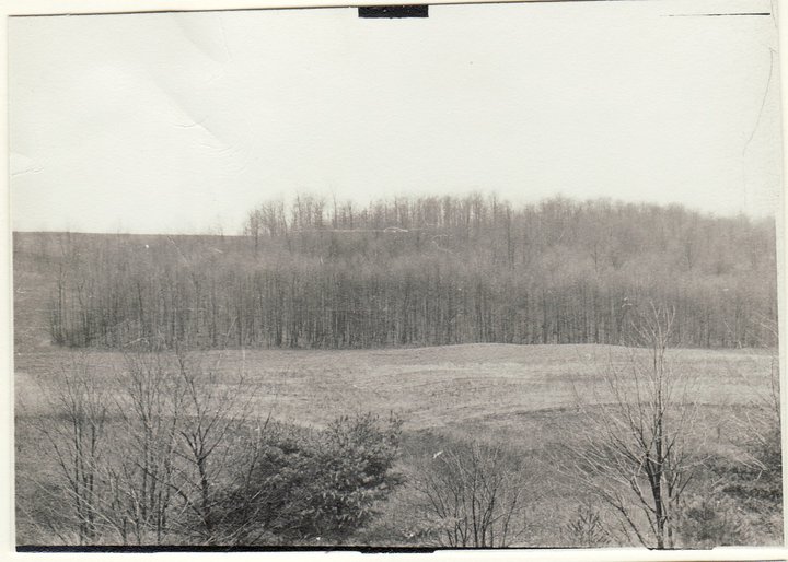
View across valley from main pond 1954.
It is nearly fall and we are taking that as a good reason to have a party. So join us on Sunday for a hike around Schribner Valley following by a campfire social. Fall wildflowers are out and the trees are still green so we will be hiking across fields and through the woods. Climbers will enjoy plenty of elevation changes, while Naturalists will take more gradual climbs to enjoy both sides of the valley.
We will meet at 3:00 at the house. The plan is to hike for 2 hours and then meet for an outdoor social around the campfire. We will grill hamburgers and hotdogs or sausage. You are welcome to bring a dish to pass or vegetables to cook. Also bring a chair and your preferred beverage. We will have bocce ball sets and kayak races on the pond for anyone interested.
Climbers and Tourists will head south along the creek. The trail will pass through a natural White Pine forest and next to a planted Norway Spruce forest. We will head down to cross the creek and head up to the top of the hill. Here, the trail will pass between a mixed planted forest (primarily Red Pine) and a Larch forest that was planted in the 1950’s and harvested in 2017.At the end of the Larches, we will enter the hardwood forest and climb as time and interest allow. Returning back to re-cross the stream, we will explore the oldest Red Pine forest on the property (planted in the 1930’s) to emerge into two fields that are deliberately being kept free of trees. The late season wild flowers are on display. We will continue around the fields and through the woods bordering them. A quick spin around the upper pond will return us to the cars.
Meanwhile the Naturalists will do the same hike in reverse, with more emphasis on flower and tree identification.
Social. A picnic social and campfire will start at 5:00 after the hike. Bring a dish to pass, a beverage and a chair.
We want to make a special invitation to all Springwater Trails alumni to come and join us for the social at 5:00 and catch up with old times.
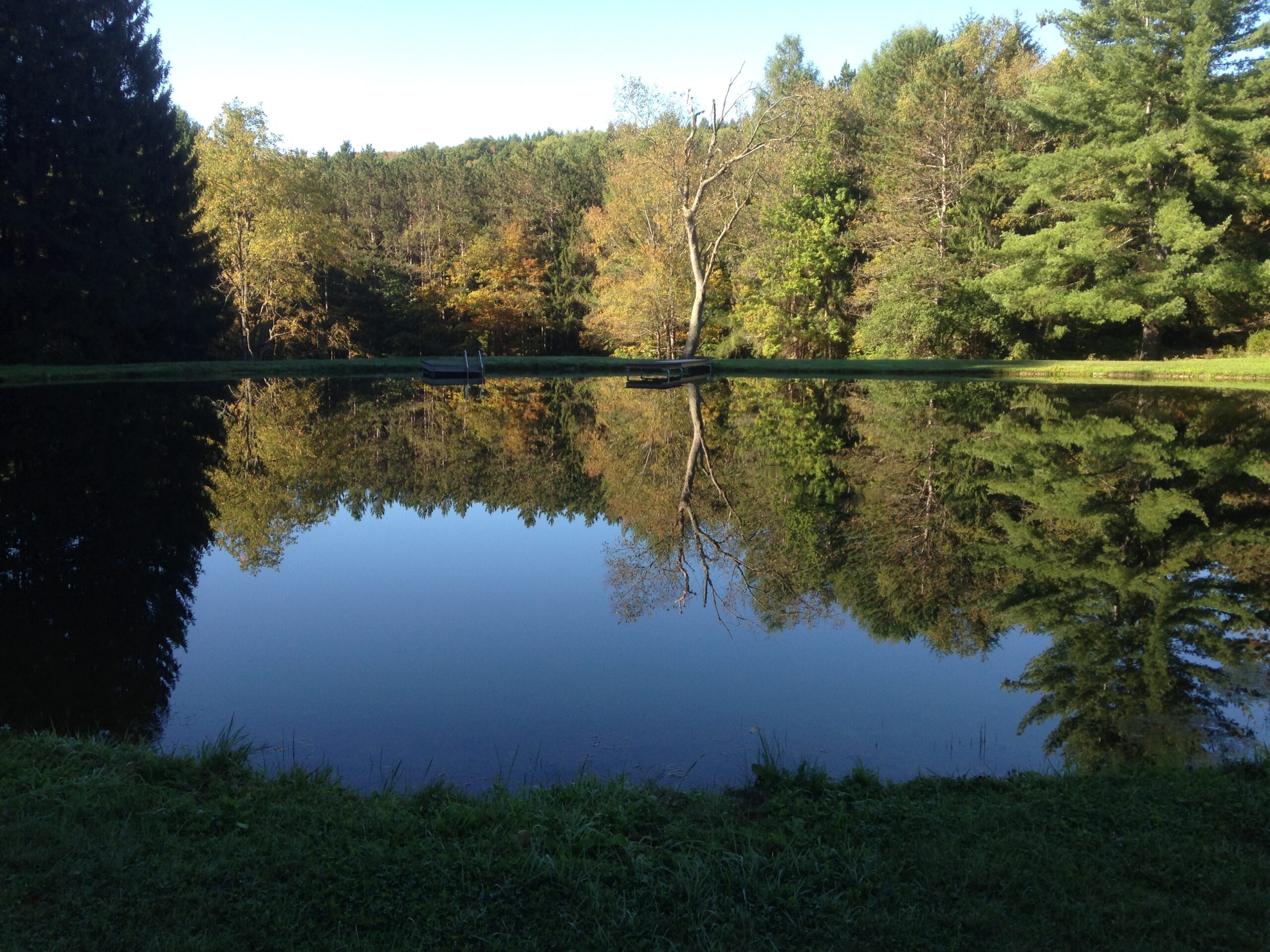
The current view across the pond. The hill and forest in the image above are now hidden by new trees.
Directions: If you use your GPS, please avoid Schribner Rd from Strutt St. The road will shake up your car. Take Giles instead. Our driveway is just below the intersection of Giles Rd and Schribner Rd. Enter the driveway and drive onto the grass to park up against the side of the barn.
From Springwater: Head south on Rt 15A from the light in Springwater. Take the first left on Marvin Hill Rd. Bear right at the Y onto Strutt St. Continue straight onto Quanz Rd when Strutt St bears right. Quanz Rd is a dirt road. Stay on Quanz Road past Fox Rd. Take the first left turn after Fox Rd onto Giles Rd. (0.7 miles from Strutt St). Follow Giles Rd to the intersection with Schribner Rd. The driveway is on the right about 10 feet past the intersection with Schribner Rd.
From Wayland: From Rt 15, head east on Rt 21 toward North Cohocton for 3 miles. Turn left on Tabors Corners Rd (Steuben Co Rd 37). The large sign on Rt 21 says Bowles Corners.After 2 miles, turn left on Schribner Rd (the second left). The driveway is the 2nd driveway on the left one mile up Schribner Rd and about 10 feet before the intersection with Giles Rd.
From Honeoye: From Rt 20A, head south on Ontario Co Rd 37. At Canadice, turn right to stay on Co Rd 37. Bear left to stay on County Rd 37. Turn left at the stop sign at Canadice Lake Road. Follow Canadice Lake Rd for 2.7 miles to the third stop sign. Turn left onto Marvin Hill Rd. Bear right at the Y onto Strutt St Continue straight onto Quanz Rd when Strutt St bears right. Quanz Rd is a dirt road. Stay on Quanz Road past Fox Rd. Take the first left turn after Fox Rd onto Giles Rd. (0.7 miles from Strutt St). Follow Giles Rd to the intersection with Schribner Rd. The driveway is on the right about 10 feet past the intersection with Giles Rd.
From the East Lake Rd in Honeoye or From Naples: Rather than traveling north to reach 20A or Co Rd 37, hikers from east of Honeoye Lake may go south to Ontario Co Rd 36 and follow Co Rd 36 to Naples. Turn right on Rt 21 south. Turn right to stay on Rt 21 for 4.5 miles to N Cohocton. Turn right to stay on Rt 21 towards Wayland. After 3.8 miles turn right on Tabors Corners Rd (Steuben Co Rd 37). After 2 miles, turn left on Schribner Rd (the second left). The driveway is the 2nd driveway on the left one mile up Schribner Rd and about 10 feet before the intersection with Giles Rd.
From Rochester: You may take your choice by going to Wayland, Springwater or Naples and following the directions from there. Rt 15A from South Ave in Rochester to Springwater is very easy, as is I-390 South to Wayland (Turn left when you get off I-390 and follow Rt 21 to Wayland).
From Fairport and Pittsford, we go through W. Bloomfield, picking up Co Rd 37 south of Rt 5 & 20 At Canadice, turn right to stay on Co Rd 37. Bear left to stay on County Rd 37. Turn left at the stop sign at Canadice Lake Road. Follow Canadice Rd for 2.7 miles to the third stop sign. Turn left onto Marvin Hill Rd. Bear right at the Y onto Strutt St Continue straight onto Quanz Rd when Strutt St bears right. Quanz Rd is a dirt road. Stay on Quanz Road past Fox Rd. Take the first left turn after Fox Rd onto Giles Rd. ().7 miles from Strutt St). Follow Giles Rd to the intersection with Schribner Rd. The driveway is on the right about 10 feet past the intersection with Giles Rd.
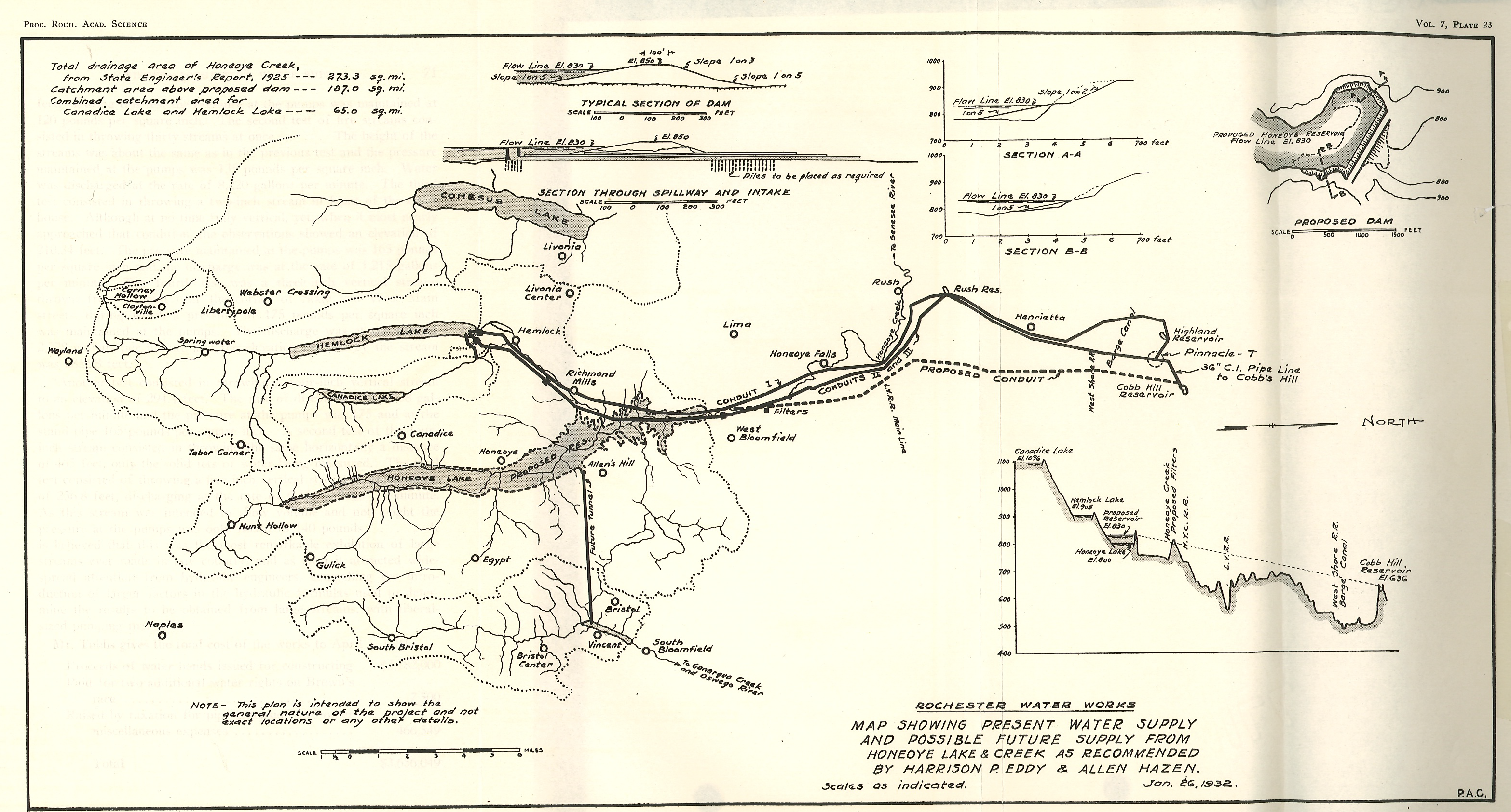
A map showing the 1932 city water supply system and a proposed addition of Honeoye Lake as an additional reservoir.
The City of Rochester started construction in 1873 of a gravity water system connecting Hemlock Lake to a reservoir in the city. The current Reservoir in Highland Park was completed in 1876. In 1887, George Ellwanger and Patrick Barry donated 20 acres of land adjoining the reservoir for the beginning of the public park system in Rochester. Over the years the original donation has grown to the 150 acre Highland Park, and to the 12,000 acre Monroe County Parks system consisting of 22 separate parks. The Ellwanger/Barry gift specified that the city would hire a landscape engineer to establish a first class arboretum with numerous trees donated from the Ellwanger/Barry Mt. Hope Nurseries. The city hired Frederick Law Olmsted Sr and Sons to design the park. Olmsted took advantage of the glacial topography of the park and in 1890 built the Children’s Pavilion on the high point of the park just east of the reservoir.
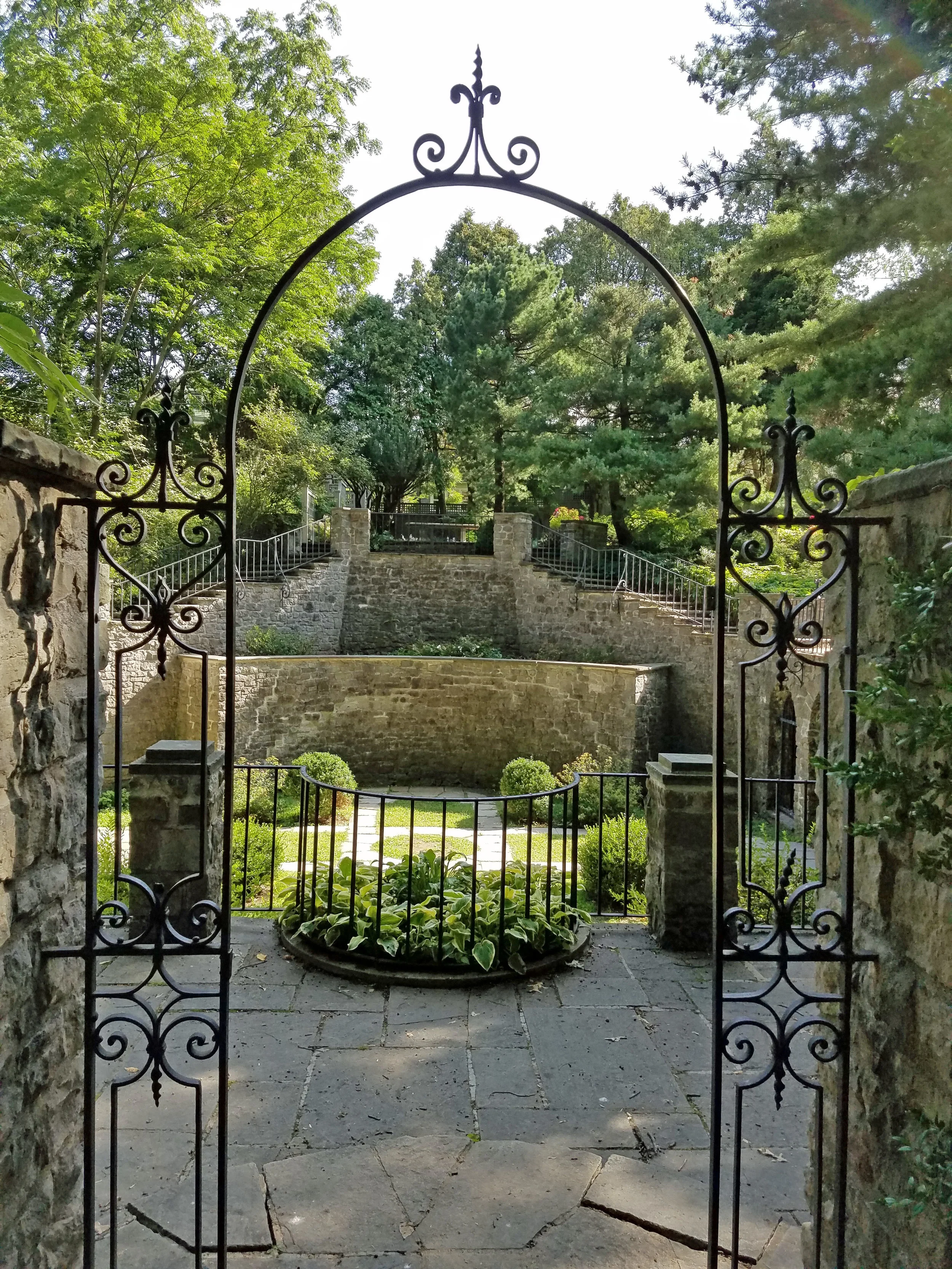 This Sunday’s hike will explore Highland Park with an emphasis on seven rare trees identified by the park department and the Sunken Gardens behind the Warner Castle.
All hikers will meet at the front of the Lamberton Conservatory on Reservoir Ave just east of South Ave. Following the hike, join us for a social at the Distillery Restaurant south of the park on Mt Hope Ave.
Directions:
From Springwater: Take NY 15A north from Springwater through Lima and Rush. (At last check, I390 was being repaved from Avon to NY 251 and is a single lane). Stay on NY 15A into the city. Cross Westfall Rd and stay to the right onto South Ave. In 1.1 miles, turn right onto Reservoir Ave. The Conservatory is on the left and parking is available on Reservoir Ave.
From Honeoye: Take US 20A west to Hemlock. Turn right onto NY 15A and follow the directions above.
From Dansville and Geneseo: Take I-390N to Rochester. Use exit 16B for NY 15A. Cross Westfall Rd and stay to the right onto South Ave. In 1.1 miles, turn right onto Reservoir Ave. The Conservatory is on the left and parking is available on Reservoir Ave.
From Naples: Take NY 21N out of Naples. Bear left onto CR 12. In 5.6 miles, turn left onto NY 64N. In 13 miles, turn left on 5 & 20. Turn right on NY 444N toward Victor. In 7 miles, turn left onto NY 96N. In 2.8 miles, use the right lane to merge onto I-490W to Rochester. Stay on I-490 into the city. Take the right exit 17 to Goodman St. Turn left onto Goodman St for 0.8 miles. Turn right onto Pinetum Dr. Stay to the left onto Reservoir Ave then right to stay on Reservoir Ave. The Conservatory is on the right and parking is available along Reservoir Ave.
From Canandaigua: To NY-332 N to the Thruway. Keep to the left at the entrance for I-90 West toward Rochester and Buffalo. Take the first exit 45 for I-490 W to Rochester. Take Exit 17 to Goodman St. Turn left onto Goodman St for 0.8 miles. Turn right onto Pinetum Dr. Stay to the left onto Reservoir Ave then right to stay on Reservoir Ave. The Conservatory is on the right and parking is available along Reservoir Ave.
Directions to the Social: Head west of Reservoir Ave across South Ave to Mt Hope Ave. Turn left onto Mt Hope Ave. In 0.3 miles, turn left onto Stewart St. The Distillery is on the right.
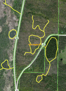
Welcome to the eighth Annual Mushroom Foray [thanks to both Springwater Trails and the Rochester Area Mycological Association] at the All Western Evergreen Farm. Three hiking groups are planned, all starting and ending at the parking area at the farm. The three groups will explore much of the farm, with many opportunities to find mycological specimens.
Please plan to arrive early (1:45 PM) to sign in and to sign the RAMA liability forms.
Maps of the farm, paper bags and paper plates for collecting and displaying mushrooms will be provided. Those who want to learn how to collect mushrooms will be instructed by Gene and Georgia, and any other Rochester Area Mycological Association members who will be our guests.
The Climbers will follow the driveway up to the fields, turning to the left at the top. We will circle the pond on the southern portion of the farm and the spruce forest along the edge of the Christmas tree plantations. Heading west through the Cathedral Pines will take us to wet spots in the woods. We will return along the edge of several more Christmas tree plantations (Douglas-fir, Nordmann fir, Grand fir, Concolor fir, Canaan fir, Alaska yellow cedar, Norway Spruce, Meyer Spruce).
The Tourists will follow the driveway up through the woods, stopping occasionally to explore for mushrooms. When reaching saleable size Christmas trees (Lot Z), head to the right around or through the Christmas tree plantation. At the corner where the small Southwestern White Pine tree row ends and the tall Concolor fir are, follow the trail into the woods and back to the field and head west along the north field road to a hidden corner of the field with some spectacular 35 foot green and blue Concolor fir Christmas trees live, the size seen during Christmas season in a large mall. If there is still time, follow the north field road next to the hedge row up to Story Road. We will return through the tillable fields, visiting smaller collections of trees and back down through the woods.
The Naturalists will start exploring under and behind the Western red cedars (thuja plicata or giant arborvitae) by the parking area and south to the Alaska yellow cedar, large Concolor fir and spruce, then back up through the woods to the right of the trail up to the main fields. These are likely full of mushrooms, but you will find some swampy areas, so don’t get lost behind people’s homes along Liberty Pole.
All hikers should check their watches and return to the parking area by 4:00 PM to have their collections identified. A portapotty with a sink is nearby.
Mushroom Identification
Once again we are fortunate to have several RAMA members (Randy Weidner, Don Tuminelli, Eugene & Georgia Binder) with us who have volunteered to identify the mushrooms collected between 4 and 5 PM. After the mushrooms are identified please join us for a social (5:00 – 6:30 PM) hosted by Katherine outside the house next to the Furnace Building. Please bring a lawn chair and your own bag lunch and beverage.
We will begin all the hikes at 6840 Liberty Pole Road where there is ample parking at the Christmas tree loading area between the tall Western redcedar and Morton Building and Nursery beds. Follow the parking signs. When we return from our foray, the mushrooms will be displayed for identification on paper plates on the tables outdoors. Please dress for the weather, rain gear as needed. Social distancing and masks are recommended when close together.
From Springwater: Go west from the Springwater light on NY-15 North. Just past the top of the hill and after rounding the tight curve, turn left on CR 38 (Liberty Pole Road). The farm is on the left (the high side) 1.1 miles from NY-15 at 6840 Liberty Pole Road after you cross Carney Hollow Rd. There is a sign for the All Western Evergreen Nursery & Christmas Tree Farm. Follow the orange cones to the parking area and park facing the house.
From Geneseo: Go south on NY-63. About 6.4 miles after passing NY-408, turn left on CR-1 (Groveland Scottsburg Rd) at Groveland Station. This road becomes CR 1A (Springwater Scottsburg Rd) at Scottsburg (Route 256) and then Liberty Pole Road after you cross Stagecoach Road (CR 71), and finally CR-38 (still Liberty Pole Rd) after crossing Reeds Corners Rd (CR-29). It is 7.1 miles from Groveland Station to All Western Evergreen Farm. The farm is on the right (the high side). Follow the orange cones to the parking area and park facing the house.
From Honeoye: Take 20A west to Hemlock and 15A south to Springwater. Then follow the Springwater directions above.
From Rochester: Take I-390S from Rochester. Use Exit 9 for NY-15 Lakeville. Turn left onto NY-15. Stay on NY-15 for 16.5 miles, through Lakeville, Livonia, Conesus and Webster Crossing. When NY-15 curves to the left at the south end of Webster Crossing, continue straight onto CR-60 (Carney Hollow Rd) and take the first right onto Liberty Pole Rd. The farm is on the left (the high side) at 6840 Liberty Pole Rd. Follow the orange cones to the parking area and park facing the house.
If using GPS, use the map directions on the www.allwesterntrees.com website and make sure you are on Liberty Pole Road and not being directed to the center of the farm from Swartz Road or Story Road. Follow the orange cones to the parking area and park facing the house.
Looking for brochure.or mailing list so I can receive it in the mail.
Nothing opens up for mailing list.
There’s all kinds of very bizarre ads and post for viagra and other drugs above on calender page.
Please let me know if there’s a brochure available