
Hikes led by Springwater Trails are generally held on Sunday afternoons and appear in this calendar in green.
| Sun | Mon | Tue | Wed | Thu | Fri | Sat |
|---|---|---|---|---|---|---|
| Lehigh Valley Trail Hike or Bike in Rush, NY 2:00 pm Lehigh Valley Trail Hike or Bike in Rush, NY @ Stevens-Connor Lehigh Valley Lodge Apr 6 @ 2:00 pm – 4:00 pm Come join us for a leisurely hike or bike along the Lehigh Valley Trail on Sunday April 6th! With its flat even surface, the trail is a hidden gem for walking, hiking, jogging, biking. It is a vital link in … Continue reading | ||||||
| Ontario County Park at Gannett Hill Hike-Naples 2:00 pm Ontario County Park at Gannett Hill Hike-Naples @ Lookout Parking area Apr 13 @ 2:00 pm – 4:00 pm  This is one of our group’s favorite hikes! Ontario County Park at Gannett Hill is one of the highest points in Ontario County and located in the scenic Bristol Hills. At an elevation of 2,256 feet above sea level, you’ll … Continue reading | ||||||
| No Hike-Easter Break 2:00 pm No Hike-Easter Break Apr 20 @ 2:00 pm – 4:00 pm No hike has been scheduled for this date due to the Easter Holiday. Enjoy the break, spend time with loved ones and eat chocolate bunnies. This will give you something to burn off next week  | ||||||
| Rob’s Trail – Hemlock Lake side 2:00 pm Rob’s Trail – Hemlock Lake side Apr 27 @ 2:00 pm – 4:00 pm Join us on Sunday April 27 to hike the west side of Rob’s Trail, the DEC/Nature Conservancy property in the northeast corner of Hemlock Lake. Options are to hike out and back to the south along the trail from the … Continue reading |
NOTICE: At a prehike on Wednesday, we were met with 18 inches of snow at the park. The FLT trail and the Yellow trail were well used giving an easy base for hiking most places. Skiers and Snow shoers will be able to go off trail on a solid crust which hikers would break through. So, we expect a good trek for all.
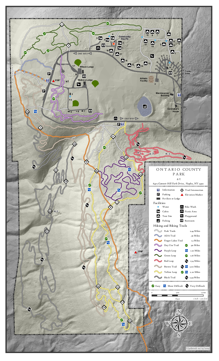
Ontario County Park provides hiking, biking, cross country skiing, fishing (no hunting), and camping or picnicking opportunities depending on the season. The park contains the highest point in Ontario County, and as a result it often has long lasting snow cover. So bring your skis, your snowshoes and your hiking boots and we will take advantage of our winter weather!
Please join us at the west parking along the main park road near the start of the Bristol Branch of the Finger Lakes Trail. Come early enough to get your equipment ready. We will start the hike at 2:00PM.
There are many trails within the park, although the bike trails are difficult to follow in the winter. The following planned hikes may change based on the weather and the snow cover on Sunday.
The Climbers will follow the Bristol Hills Branch of the FLT out to the overlook and then around to the south to the FLT sign-in box. At that point, we will turn around, and follow the yellow trail back through intersections 13, 11, 8, 7, 6, 5 and 4 to the park road. Crossing the road, we will cross the fields to the purple trail back to the cars. Climbers are invited on snow shoes and hiking boots. Poles will be helpful at slippery locations.
The Naturalists will also follow the Bristol Hills Branch past intersection 10 to intersection 8. Then turn left to follow the yellow trail through intersections 7. At intersection 6, the group has the choice between staying on the yellow trail or exploring the upper sections of the red trail. Back at the road, the brown trail on the left of the road, or the purple on the right will be followed back to the cars.
Meanwhile Skiers will also head out to the overlook, but will turn north to follow the park trail though intersection 1 and on to the campgrounds. From there, we will cross the field to the pond, check out the red trail and head back to the cars on the brown trail or back across the fields. Conditions may dictate changes to this route.
There will be no planned social following this hike. If you are hungry, Brews and Brats, and Hollerhorn Distilling plan to be open Sunday according to their Facebook pages.
Directions: The easiest route to the park is to take NY 64 to Bristol Springs and turn west on Gannett Hill Rd. There is a sign indicating Ontario County Park. At the top of the hill turn right onto South Gannett Hill Road. The park entrance is straight ahead. Follow the park road for about .5 miles to our meeting place which is the parking area along the park road near the information kiosk at the Finger Lakes Trail trail-head.
NOTE: Daylight Savings Time starts today. Please check your clocks!
Our Sunday event originally planned a ski or snowshoe excursion on the groomed trails of Harriet Hollister Spencer State Park. The Park has been well used over the past few weeks of snowy weather, and the groomers keep the trails in great condition for both fast and slower skiers and for those on snowshoes. Since we’re not sure what effect the recent warming will have on the snow, it is highly unlikely that skiing or snowshoeing will be possible.
Meet at 6775 Canadice Hill Road in Canadice. Park in the main lot near the road. Restrooms are available next to the lot. We will divide into groups depending on desired activity and distance.
Naturalist: Good easy trails for hiking are the main road past the overlook and the inner service area, looping back on Raccoon Run. For a detailed look at the routes and difficulty, see winter trails map for the options:
Tourists: Starting from the parking lot heading out on Ruthies Trail and connecting with Chalet trail, makes for a pleasant hike. Head up Whiteface to Blue spruce and connect with Racoon Run or Sidewinder.
Climbers: Climbers can also head out Ruthie’s Trail and connect with the Chalet trail and take the snowmobile trail C4 out of the main park, out to the junction of Townline and Canadice Road. Best guess; returning back to the park along Canadice Hill Road may not be a good option. The road may be very muddy. Heading back on C4 into the main park might be a better choice.
Hiking conditions caused by weather changes, will try to be updated as hike day nears.
Please join us for an early spring hike along the Finger Lakes Trail in Slader Creek State Forest south of Canaseraga. This hike will be an in and out with the opportunity to make it a loop with a bit of off-trail hiking in the Forest.
All hikers with take the same route south from Slader Creek Rd. The hike begins with a nice new stile over the farmers fence, and then a careful walk across the creek and through the cow pasture. The cows are quite tame and seem more interested in eating than in investigating any hikers.
From the pasture we will follow the farmers road up the hill. Total elevation change is about 400 feet. There are two additional stiles as we pass through a couple of pastures separated by fences. Be sure to turn around and enjoy the view to the north before we enter the forest.
At about a mile and a quarter, we with reach the FLT sign-in mailbox. At this point, the climbers will have the opportunity to leave the trail and make our way along at route 35° east of north to a road out to Slader Creek Rd and then a road walk back to the cars. Of interest on the road walk is a handsome one room school house on the south side of the road.
Meanwhile the Tourists and Naturalists can continue on the FLT trail for another half mile, or until 3:10 or when the trail crosses onto private land which is currently being logged. Since this is active logging, we will turn around and return on the same trail to the cars.
SOCIAL: If the weather permits, following our hike we will check out the Village Park in Canaseraga for an outdoor social. Bring a sandwich and something to drink. There are picnic tables where we can sit safely and catch up on news we missed on the hike.
Directions:
From Dansville and points east: Head south on NY-36 past Stony Brook. Turn right onto CR 70. At the flashing light in Canaseraga, turn left on S Church St. In 1.3 miles, turn right onto CR 13c (Slader Creek Rd). In three miles, you will see a gate and stile on the left. Park on the north side of the road.
From Mt Morris and points west: Head south on NY 408 through Nunda. In 2.6 miles south of NY 436 (Mill St) in Nunda, turn left onto NY 70. In 11.4 miles at the flashing light in Canaseraga, turn right onto S. Church. In 1.3 miles, turn right onto CR 13c (Slader Creek Rd). In three miles, you will see a gate and stile on the left. Park on the north side of the road.
From Hornell and points south: Head north on NY-36 to Arkport. At the stop light in Arkport, turn left onto West Ave (NY 961F). Stay on NY 961F for 3.8 miles. Turn left onto Tildon Hill Rd for 1.9 miles. At the tee, turn rignt onto CR 13A, then a quick left onto Narrows Rd. In 1.1 miles at the tee, turn left onto CR 13c. In 1.7 miles you will see a gate and stile on the left. Park on the north side of the road.
From Rochester and points north: Head south on I-390. Take exit 4 onto NY 36 S (the second exit in Dansville). Turn right on NY-36 past Stony Brook. In 6 miles, turn right onto CR 70. At the flashing light in Canaseraga, turn left on S Church St. In 1.3 miles, turn right onto CR 13c (Slader Creek Rd). In three miles, you will see a gate and stile on the left. Park on the north side of the road.
Directions back to Canaseraga and the village park: Continue west on Slader Creek Rd. Turn right onto Friener Rd. In 3 miles, turn right onto NY 70. At the flashing light, turn right onto S Church St. Cross the tracks and take the first right onto Bennett St. The park is at the end of Bennett St.
Climbers and Naturalists: We will meet at the South (Campground) Entrance to the park and split into two groups (Climbers and Naturalists). Climbers will hike in a loop around the entire park using the East and West Snowmobile Trails. There are some significant up hills and down hills on this route which is about 3.5 miles total. Naturalists will hike to the south out and back on a park access trail through the woods and then through the campground and down to the creek for a total of several miles. There are large oaks, white pines and other impressive trees on this route. Although it goes without saying – all hikers should carry drinking water.
Trail Closures: Please note that the Gorge Trail and the East and West Rim Trails are currently closed to the public. According to the Assistant Park Manager the Gorge Trail is not expected to be opened until late May because they need to complete scaling the stone cliffs in the gorge, and the East and West Rim Trails are not expected to be opened until sometime in mid April because they are working on replacing some of the stairs on these trails.
Social: If the weather is favorable and you would like to meet for an outdoor social in the park after the hikes, plan on bringing your own sandwich and drink. Drive the mile or so to the North Entrance and the first ones there should get a picnic table or two near the Clara Barton Shelter.
Directions: From the Village of Dansville drive south on NYS Route 36 south towards Hornell and go past the North Entrance to the park. At the top of the hill take the first left onto Co Rte 47. In a short distance, take a quick left into the South Entrance. Park near the Camp Office without blocking the drive.
We are taking the week off. Please join us next Sunday in Webster at the Gosnell Big Woods Preserve and the neighboring Whiting Road Nature Preserve.
This Sunday, Springwater Trails will return to Webster for hikes at the Gosnell Big Woods Preserve. Naturalists will follow trails within Gosnell Big Woods. Gosnell is a mix of flat, around Big Field and short hills. The Climbers will include both trails in Gosnell Big Woods and in the neighboring Whiting Road Nature Preserve. Whiting is hilly.
The meeting point will be at the Parking area close to the intersection of Vosberg & Drumm Roads.
There doesn’t appear to be a picnic area at the Preserve, but hikers comfortable with supporting restaurants will meet at Flaherty’s Three Flags Inn for an after hike social.
Directions:
From Springwater: Take NY 15A north to get on I-390 N (either in Avon off of 20W, or in Henrietta). In Rochester, keep right at exit 15 to get on I-590. Stay on I-590 for 4.5 miles to Exit 10, 104E to Webster. Take the Bay Rd exit and turn right onto Bay Rd headed north. In 1.3 miles turn right onto Klem Rd. In 0.7 miles turn left onto Drumm Rd. In 0.7 miles, as the road turns left to become Vosberg Rd, the parking lot is on the right.
Directions to Flaherty’s: Return on Drumm Rd and Klem Rd to Bay Rd. Turn left on Bay Rd, and in 2.7 miles, Flaherty’s will be on the left (just before a light).. It may be easier to turn left at the Kidd Castle Way light and then two quick lefts.
Join the Canandaigua Lake Watershed Association at Bare Hill to learn more about the gypsy moth infestation. You will learn to identify and remove gypsy moth egg masses. This is one of three events scheduled for Saturday, April 17; Friday, April 24; and Saturday, May 1, from 10:00 a.m. to 12:00 p.m. You are encouraged to register early to allow the organizers to gauge interest and ensure proper supplies are available.
This month we are skipping west on the Finger Lakes Trail to a section that Springwater Trails has never hiked. The trail is on private land which is used by the owners for hiking, but we are invited to enjoy the forest outside hunting seasons. This weekend we will see the early blooming of spring, with trees budding out at the lower elevations. Without the undergrowth, views of the forest floor are available throughout the hike, including views down to Route 70 in the valley below.
.I am hoping that hike leaders will want to investigate the sections of the FLT that we have skipped, including the section north of last month’s hike at Slader Creek Rd across open fields and past the Bossard’s Cabin which is available for backpackers. Also, check out the Robinson Loop trails near Swain, which have been a favorite for Springwater Trails in the past. Finally, there is a section of the FLT within Rattlesnake Hill WMA which we may return to next month.
This week’s hike will be an out-and-back for all hikers. We will have two groups, allowing for different hiking speeds. The hike overall is downhill on the way out, so we will turn around after 50 minutes, allowing a bit more than an hour to return to the cars. The trail is blazed the entire way, but stay aware to stay on the marked trail when it leaves the landowner’s logging trails.
All hikers will meet on Fox Hill Rd across from the home at 2146 Fox Hill Rd. The FLT is a road walk up Fox Hill Rd, and enters the field and then forest at our meeting place.
Following the hike, those who are interested will select a location for a social. There is the Sierra Inn in Swain or the Sunrise Restaurant or Jack’s Place in Dansville or Wayland to select from.
Directions:
From Springwater, Wayland and Naples: Take NY-15 S (or NY-21 S from Naples) to Wayland. Turn right at the light onto NY-63 to Dansville. Turn Left onto Ossian St (NY-36 N). Continue straight to stay on Ossian St NY-436. In 7.1 miles turn left onto Shute Rd. In 2.6 miles, turn left onto Newville Rd (CR 54), Turn left on NY-70 N (2.1 miles). The first left (in 3.5 miles) is State St. Turn left on State St (CR 24) through the Hamlet of Dalton. Turn left to stay on CR 24, then at the next intersection continue straight onto Fox Hill Rd (CR 24 bears right). Follow Fox Hill Rd to the top and stay on the road around the right turn. Its about 0.2 miles from the corner to the south edge of the second field and the FLT yellow sign. Park on the shoulder on the left (East) side of the road.
From Rochester, Geneseo and Mt Morris: Take I-390 south to exit &, NY 408S into Mt Morris. At the light in Mt Morris, turn left, then a quick right to stay on 408, through Nunda. At NY-70 continue straight through the intersection onto CR 24 (State St) through the Hamlet of Dalton. Turn left to stay on CR 24, then at the next intersection continue straight onto Fox Hill Rd (CR 24 bears right). Follow Fox Hill Rd to the top and stay on the road around the right turn. Its about 0.2 miles from the corner to the south edge of the second field and the FLT yellow sign. Park on the shoulder on the left (East) side of the road.
Join the Canandaigua Lake Watershed Association at Ontario County Park to learn more about the gypsy moth infestation. You will learn to identify and remove gypsy moth egg masses. This is one of three events scheduled for Saturday, April 17; Friday, April 24; and Saturday, May 1, from 10:00 a.m. to 12:00 p.m. You are encouraged to register early to allow the organizers to gauge interest and ensure proper supplies are available.
Looking for brochure.or mailing list so I can receive it in the mail.
Nothing opens up for mailing list.
There’s all kinds of very bizarre ads and post for viagra and other drugs above on calender page.
Please let me know if there’s a brochure available