
Hikes led by Springwater Trails are generally held on Sunday afternoons and appear in this calendar in green.
| Sun | Mon | Tue | Wed | Thu | Fri | Sat |
|---|---|---|---|---|---|---|
| Lehigh Valley Trail Hike or Bike in Rush, NY 2:00 pm Lehigh Valley Trail Hike or Bike in Rush, NY @ Stevens-Connor Lehigh Valley Lodge Apr 6 @ 2:00 pm – 4:00 pm Come join us for a leisurely hike or bike along the Lehigh Valley Trail on Sunday April 6th! With its flat even surface, the trail is a hidden gem for walking, hiking, jogging, biking. It is a vital link in … Continue reading | ||||||
| Ontario County Park at Gannett Hill Hike-Naples 2:00 pm Ontario County Park at Gannett Hill Hike-Naples @ Lookout Parking area Apr 13 @ 2:00 pm – 4:00 pm  This is one of our group’s favorite hikes! Ontario County Park at Gannett Hill is one of the highest points in Ontario County and located in the scenic Bristol Hills. At an elevation of 2,256 feet above sea level, you’ll … Continue reading | ||||||
| No Hike-Easter Break 2:00 pm No Hike-Easter Break Apr 20 @ 2:00 pm – 4:00 pm No hike has been scheduled for this date due to the Easter Holiday. Enjoy the break, spend time with loved ones and eat chocolate bunnies. This will give you something to burn off next week  | ||||||
| Rob’s Trail – Hemlock Lake side 2:00 pm Rob’s Trail – Hemlock Lake side Apr 27 @ 2:00 pm – 4:00 pm Join us on Sunday April 27 to hike the west side of Rob’s Trail, the DEC/Nature Conservancy property in the northeast corner of Hemlock Lake. Options are to hike out and back to the south along the trail from the … Continue reading |
Due to thunder storms, we have cancelled both the hike and the annual meeting. We will have more information about the annual meeting this coming week.
You may remember that last March we had our annual meeting scheduled at the Springwater Center, but had to cancel it because of COVID – Yes, it was only 4 months ago – seems like years. Anyway, with outdoors gathering with social distancing or masks being allowed now, we have planned our 2020 Annual Meeting for this coming Sunday during the social. Please join us for Hiking and Kayaking on Hemlock Lake, followed by a social and annual meeting in the Reynolds Gull parking area.
All hikers and boaters will meet at 4:00 at the south boat launch on Hemlock Lake. Boaters should plan to arrive 15 minutes early to have time to unload their boat.
After a group picture, each group (hikers and boaters) will select their leaders. It is recommended each group select two leaders to allow for different distances of the participants. Leaders will work to keep their group together through the hike.
The boaters will cross the lake and explore north along the shoreline. Hemlock Lake is 7 miles long and 0.5 miles wide. Planning on 2 hours on the lake, we will paddle north, then cross back to the east side at about 5:00 and follow the hikers back to the boat launch.
Meanwhile, hikers will head north on the old lake road that went the length of the lake a century ago. This trail is now a dead end, but hikers who want additional adventure may select a point to explore up the hill away from the lake.
Upon return to the boat launch, all hikers and boaters are invited to reconvene at the entrance to Reynolds Gull for a social and the Annual Meeting. Bring your own snack and beverage and a chair to sit on. Move your car from the boat launch to the large lot on the west side of Rt 15A across from Reynolds Gull. Cross Rt 15A carefully. While you wait for the group to gather, a short hike up Reynolds Gull is available. Please stay safe and do not climb the walls of the gorge.
Annual Meeting Agenda
- Officer nominations
President, Vice President, VP of Hiking, Treasurer and Secretary - Election of Officers
- Sign up for 2020 memberships at the discounted price:
Individual – $10
Family – $15
Cash or Checks accepted.
Directions
For those unfamiliar with Hemlock Lake, see the directions to the South Boat Launch. There is a large parking area at the start of the dirt road to the boat launch which we will use to park for the social. And there is a small parking lot across Rt 15A at the entrance to Reynolds Gull.
This Sunday’s hike will be a maintenance session on Wheaton Hill in Springwater. We won’t be attempting to whack all the grass this year, just the long grass around the access trails.If you want to do more you are welcome to bring a weed whacker and have at it. If you do plan to use a weed whacker, PLEASE BRING EYE PROTECTION! These devices can kick up a lot of dust and small stones. We will be cutting back the roses and other growths, and we’ll be sawing up some trees that have fallen across the trails. If the grass is too long for comfortable walking we will call in the City of Rochester to cut it – they have heavier equipment than we can bring to bear.
Bring gloves to protect your hands, loppers to cut branches and if you have one, a small saw for branches that are too large for the loppers.
The Social:
The plan for a social afterwards is to picnic with our own food parcels and keep a prudent social distance between us. Please bring a folding chair for this – there is nowhere to sit on Wheaton Hill.
Directions:
Wheaton Hill is the first right turn north of the intersection of Rt 15 and Rt 15A in Springwater (0.9 mile north of the intersection). The trail head is 0.5 miles up Wheaton Hill just before the road turns straight east and heads up the main hill. More details are on the directions page.
What to bring:
- Gloves and clippers – hand clippers or long handled loppers for larger branches.
- A weed whacker if you want to cut grass, with gas mixture and extra string.
- Small bow saw.
- Plastic grocery bags in case you find any litter.
- Water to keep hydrated.
- Eye protection.
This Sunday we’ll return to an old favorite, a walk in the woods at the Wesley Hill Preserve, with a bring-your-own picnic social afterwards next to the new living willow structure at Cummings Nature Center. Social distancing standards are in effect. 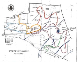
Meet at the Gulick Road parking area at 3:45 for a 4pm start. the Climber group will follow the Red, Yellow and Blue Trails for a total of about 4 miles. The Tourists and Naturalists will follow the Red Trail with a short cut back to the parking area on the Green Trail, for a total of about 2.5 miles.
Wesley Hill is a Finger Lakes Land Trust property of 390 acres on the hill east of Honeoye Lake. including stands of northern hardwoods, red and white pines, hemlocks, a woodland pond, and the northern edge of Briggs Gully, as well as the Wenrich Cabin, set in an old forest overlooking the gully, deep in the woods. The preserve was established in 1999 by the generous donation of 90 acres by the children of three artists – John Wenrich, James Havens and Colburn Dugan – to the Finger Lakes Land Trust. Since that time, the Land Trust has expanded Wesley Hill through the purchase or donation of four additional parcels.
Social: Following the hike, the social will be on the grounds of Cummings Nature Center, about 1.4 miles south of Wesley Hill along Gulick Road. Enter the grounds from the south end of the parking lot, and proceed to the benches near the start of the Cathedral Trail. Bring a lawn chair if you have one, for social distancing. The Nature Center has planted a Willow Dome in this corner of the property that you won’t want to miss – it’s a cross between a maze, an igloo, a chicken house and a thicket. See https://www.willowsvermont.com/diy-structures.html
Directions: 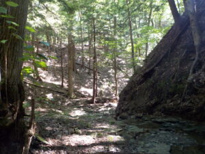
From Honeoye: take route 20A east through Honeoye to East Lake Road (CR 33). Turn right onto East Lake Road. (If coming from Bristol or points east, it’s a left onto East Lake Road). Take the first left, staying on CR 33, then the first right onto Pinewood Hill which becomes Gulick Road. Travel about 5 miles to Wesley Hill Parking Area on the right side. Parking lot has been enlarged and can fit about 16 vehicles; any late comers can park on the side of the road.
From Springwater: Head north on Rte. 15A toward Hemlock. Just before Hemlock, turn right on Rte. 20A. Follow Rt 20A to Honeoye and then follow the directions above.
From Naples: From the southern end of Naples, head west on Co Rd 36. Follow Co Rd 36 for 1.2 to the first right turn on Gulick Rd. Follow Gulick for about 7 miles. The parking area is on the left.
Directions to the Social from the trailhead:
Via Gulick Rd: Turn right out of the parking area on Gulick Road. Go about 1.4 mile to Cummings Nature Center parking lot on the right. Go to the end of the parking lot, and enter the property on the right. You will see the bench grouping and the willow dome straight ahead.
Please note – boat rentals are available for this event, but we need advance notice by the end of the day Thursday the 6th. See rental details below.
August 9 looks like a good day for a serene paddle at the northwest corner of Keuka Lake , or a hike along the shore. Our starting point will be the Finger Lakes Museum site, accessible from Guyanoga Road or from Route 54, both close to the flashing light at the center of Branchport. The Finger Lakes Museum is a former elementary school which is being gradually converted to a regional museum. https://www.fingerlakesmuseum.org/ They have an active boat launch site at the rear bordering Sugar Creek, the main tributary into the west branch of Keuka Lake. 
Bring your own kayak or canoe and there is no charge – just show up at 3:30 to unload your boat and launch from their floating dock. Allow 1.5 to 2 hours for paddling and another half hour for takeout and loading. Please use a mask while using the boat launch in both directions.
This is a self-guided paddle with three distinctly different environments. Heading upstream in Sugar Creek takes you winding through a woodland waterway. Heading downstream to the lake you pass the adjacent marshland owned by the Isaak Walton League, with two waterway entrances a short distance west on the lake. Cattails, water lilies and waterfowl are abundant in the marsh waterways. On the lake you can head west to explore the marinas of Branchport or east toward Keuka Lake State Park. Even if it’s a bit choppy on the lake, the stream and marsh will be calm.
For Hikers: For those who prefer to explore the Keuka shoreline on foot, we will hike from the Museum to the lakefront, first on the west side of Sugar Creek to an observation platform overlooking the march and the lake, and then to the Museum’s lakefront pavilion on the west side of Sugar Creek, including a dock where we can dangle our feet in the lake or change places with one of the boaters. This will be a short hike of 2.5 miles or less.

Social: Bring your own snack or picnic to enjoy at the Museum’s Creekside Center.
Boat Rental details: If you want to rent a boat from the museum, let Saralinda know by the end of the day on Thursday the 6th at sh73sh73@yahoo.com. Boat rental is $30 per boat. There are two tandem kayaks and two tandem canoes available, plus lots of single kayaks. If you have your own life preserver and paddles, bring them along (this is preferred for sanitation reasons); otherwise they will be provided with the rental. Payment is by check or cash at the start of the event. You will need to sign a liability waiver. The Museum’s Covid-safety protocols, can be found at:
Directions:
From Springwater and Wayland – Take Route 15 south and then Route 21 north to Naples. Coming into Naples, go right on Route 53 toward Prattsburgh. In 1.2 miles make a left on Italy Valley Road. You will remain on Italy Valley Road for about 8.7 miles, although the county road number changes from 21 to 18 to 34 en route. At the end of Italy Valley Road, go left for .3 miles on Italy Hill Road (CR 35), then follow Itlaly Hill Road as it curves to the right and becomes CR32. In another 4.7 miles you will be at the flashing light in the center of Branchport. Go straight on Route 54A toward Penn Yan for .2 miles, and turn left into the Finger Lakes Museum across from the Library, and before the Fire Station. Look for the driveway toward the new barn on your right.
From Canandaigua and 5&20: Take East Lake Road south to County Road 1, or Route 247 from Reed’s Corners into Rushville. Continue South through Rushville toward Penn Yan. Route 247 will become Route 364 shortly before Potter. Continue for 4.5 miles past Potter and make a right on Guyanoga Road (CR 29). Go another 6.5 miles to Branchport. Turn left into the Finger Lakes Museum at 3369 Guyanoga Road, or if you miss it, go left at the flashing light and then left into the FLM drive. If you come in from Guyanoga Road, go to the right around the building and parking lot, and follow the signs to the Creekside Center (a new barn). Park on the grass near the boat rack. If you take the side entrance in from Route 54A heading east toward Penn Yan, turn in to the left, across from the library, and then right into the Creekside Center.
This Sunday we’ll be hiking the trails around Camp Cutler, the scout area between Gulick Road and Hunt Hollow Road in Naples.You can download the trail map from https://springwatertrails.org/wp-content/uploads/2020/08/Camp-Cutler-Trails-791×1024.jpg Here’s what it looks like.
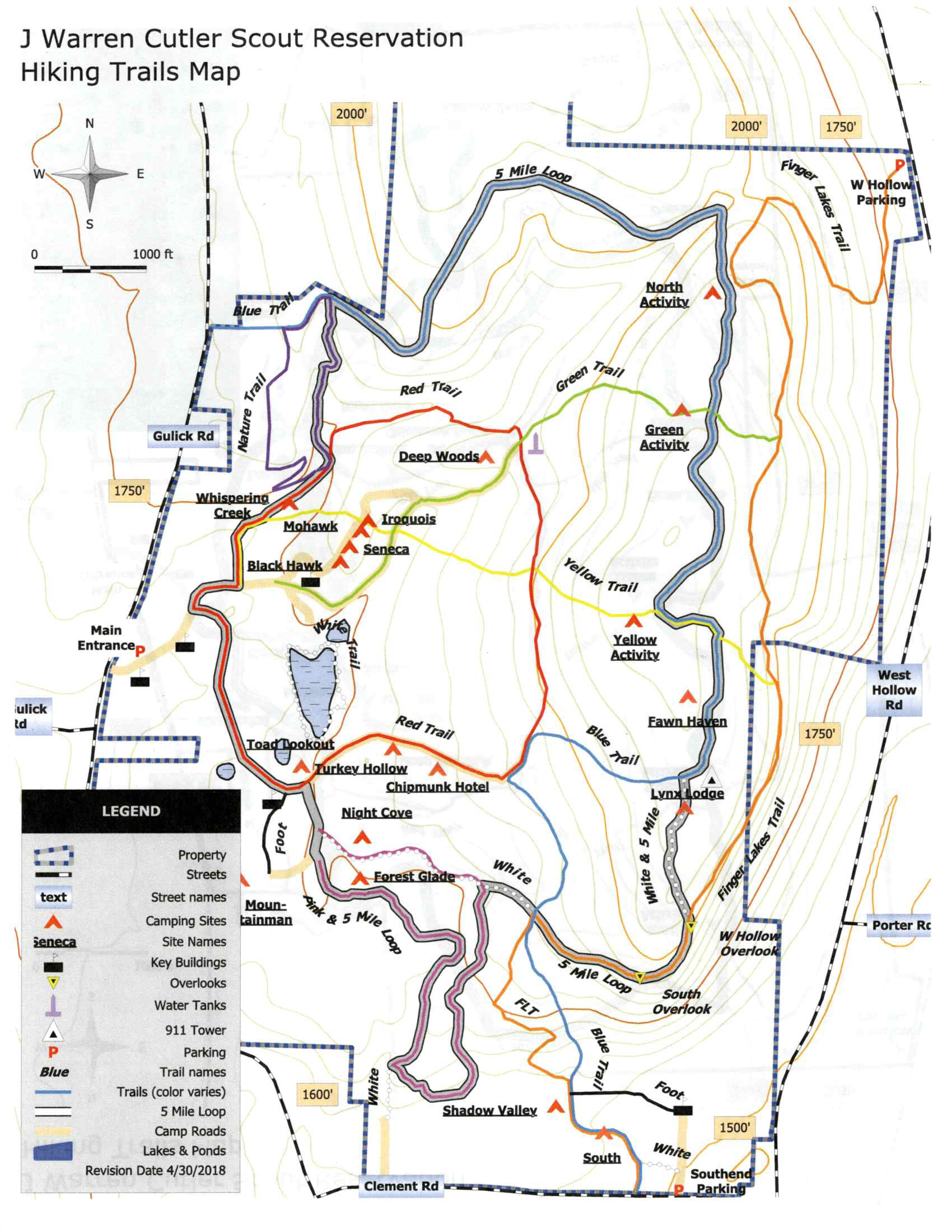 We’ll meet in the camp; there’s a notice shelter just inside the main entrance off Gulick Road at the edge of a large car park. We’ll divide into 3 groups, climbers, tourists and naturalists. All groups will start off together, walking north from the parking lot.
The trails are well marked with colored blazes except at the beginning, oddly enough! Once the blazes start up the trails are easy to follow, but always look for the next blaze! The trails tend to switch direction sharply, making it easy to wander off and have to double back to find blazes again. The woods are well worn near where the scouts camp and congregate but become thicker and more natural further out. Likewise, the trails are broad and vehicle worn near the entrance, but narrower and grassy at the outer edges of the area.
All groups will start out together following the camp roads. At the first fork, stay to the left at the start of the red trail (no blazes yet). A short distance up the hill, you will see a sign for the Nature Trail. Turn left off the road onto the blazed red trail.
The naturalists will follow the red trail until it separates from the purple trail. They will turn right and keep following the red blazes. They will turn right on the green trail back to the starting point.
The tourists will follow the red trail until it separates from the purple trail. They will turn right and keep following the red blazes all the way back to the starting point.
The climbers will follow the red trail until it separates from the purple trail. They will turn left following the purple blazes north to the blue trail, a well worn 4 wheeler trail. Turn right on the blue trail. all the way around the perimeter of the scout land. In total this is a 5 mile hike; if it’s a hot day, or time is running short there are several trails that cut straight back to the starting point. Each of these cuts take about 30 minutes.
The Social
We’ll have a lunch bag social again. There doesn’t seem to be anywhere comfortable to gather at the scout camp so we’ll go back to the Willow Dome at the Cummings Nature Center. See https://www.willowsvermont.com/diy-structures.html
Directions:
From Honeoye: take route 20A east through Honeoye to East Lake Road (CR 33). Turn right onto East Lake Road. (If coming from Bristol or points east, it’s a left onto East Lake Road). Take the first left, staying on CR 33, then the first right onto Pinewood Hill which becomes Gulick Road. Travel about 7 miles to Camp Cutler on the left side. .
From Springwater: Head north on Rte. 15A toward Hemlock. Just before Hemlock, turn right on Rte. 20A. Follow Rt 20A to Honeoye and then follow the directions above.
From Naples: From the southern end of Naples, head west on Co Rd 36. Follow Co Rd 36 for 1.2 to the first right turn on Gulick Rd. Follow Gulick for about 5 miles. The parking area is on the right.
Directions to the Social from the Trailhead:
Via Gulick Rd: Turn right out of the parking area on Gulick Road. Go about 2 miles to the Cummings Nature Center parking lot on the left. Go to the end of the parking lot, and enter the property on the right. You will see the bench grouping and the willow dome straight ahead.
This Sunday we will explore the relatively secluded southern section of Harriet Hollister Spencer State Park. The Park is a high point, several degrees cooler than the surrounding lowlands, and the hike is all in the woods – a good spot for a hot day.
Meet at 6775 Canadice Hill Road in Springwater. When you pull into the park entrance, pass the large parking lot and head straight ahead for the interior parking area near the center of the trails, passing the scenic overlook on the way. Park near the shelter and rest rooms. Our hike will take us south, looping around on the Blue Spruce Trail to the C4 trail which links the main part of the park with the southern section. Our destination is an open field between the two park sections with a long vista to the southwest, toward Springwater.
Tourists and Climbers will follow the same route, with the Tourists returning after 45 minutes for a roughly 90 minute hike. The Climber route is about 3 miles and 2 hours. The trail is wide and generally well groomed, used by snowmobilers in the winter. There are a few ups and downs, but it is mostly easy walking through hardwood and conifer forest.
Social: We will gather at the lean-to near the cars for a bring-your-own picnic. There is one picnic table and the edge of the lean-to available for seating; for a higher standard of comfort, bring your own lawn chair.
Directions:
From Springwater, take East Avenue up the hill and then a left on Canadice Road (CR42). Make a right on Town Line Road, a.k.a Tibbals Road. At the end, make a left on Canadice Hill Road. Go about 1.7 miles to the park entrance on your right.
From Honeoye/Hemlock: Take Route 20A east from Hemlock or west from Honeoye to the intersection with County Road 37. Go south approximately 3.7 miles to the point where County Road 37 curves to the right; go straight here on Canadice Hill Road. In another 3.3 miles the road will fork; take the left fork (dirt road) to remain on Canadice Hill Road. In another .7 miles you will see the park entrance on your left.
You may remember that last March we had our annual meeting scheduled at the Springwater Center, but had to cancel it because of COVID – Yes, it was only 4 months ago – seems like years. Anyway, with outdoors gathering with social distancing or masks being allowed now, we have planned our 2020 Annual Meeting for this coming Sunday during the social. Please join us for Hiking and Kayaking on Hemlock Lake, followed by a social and annual meeting in the Reynolds Gull parking area.
All hikers and boaters will meet at 4:00 at the south boat launch on Hemlock Lake. Boaters should plan to arrive 15 minutes early to have time to unload their boat.
After a group picture, each group (hikers and boaters) will select their leaders. It is recommended each group select two leaders to allow for different distances of the participants. Leaders will work to keep their group together through the hike.
The boaters will cross the lake and explore north along the shoreline. Hemlock Lake is 7 miles long and 0.5 miles wide. Planning on 2 hours on the lake, we will paddle north, then cross back to the east side at about 5:00 and follow the hikers back to the boat launch.
Meanwhile, hikers will head north on the old lake road that went the length of the lake a century ago. This trail is now a dead end, but hikers who want additional adventure may select a point to explore up the hill away from the lake.
Upon return to the boat launch, all hikers and boaters are invited to reconvene at the entrance to Reynolds Gull for a social and the Annual Meeting. Bring your own snack and beverage and a chair to sit on. Move your car from the boat launch to the large lot on the west side of Rt 15A across from Reynolds Gull. Cross Rt 15A carefully. While you wait for the group to gather, a short hike up Reynolds Gull is available. Please stay safe and do not climb the walls of the gorge.
Annual Meeting Agenda
- Officer nominations
President, Vice President, VP of Hiking, Treasurer and Secretary - Election of Officers
- Sign up for 2020 memberships at the discounted price:
Individual – $10
Family – $15
Cash or Checks accepted.
Directions
For those unfamiliar with Hemlock Lake, see the directions to the South Boat Launch. There is a large parking area at the start of the dirt road to the boat launch which we will use to park for the social. And there is a small parking lot across Rt 15A at the entrance to Reynolds Gull.
Hike Description
This hike will be on a section of the Bristol Hills Branch of the Finger Lakes Trail (Map B3) and include the Bog Nature Trail Loop. Most of the hike is in Urbana State Forest, Steuben County.
NOTE: The start time for this hike is 2:00 because it is September. Hikes will return to 4:00 in May.
We will start from the trailhead on Bean Station Road. Following the orange blazes, we will head south past the restored Covell Cemetery and the Evangeline Shelter then climb steadily uphill through a hemlock and oak woods to the state forest and onto the top of the plateau. Tourists and naturalists will go as far as the bog observation deck and then back track to Bean Station Road (~3miles total). Climbers will continue on past the overlook and follow the Bog Nature Trail Loop clockwise returning to Bean Station Road by way of the blue blazed side trail and then the main trail (~4.5 miles total).
Directions to Meeting Location
From Springwater: Head south on NY 15 to Wayland. Turn left onto NY 21, Turn left in N Cohocton to stay on 21 into Naples. Turn right onto NY- 53. Stay on NY-53 through Prattsburgh. Follow the directions below.
From Prattsburgh, take NY- 53 South for 2.6 miles to Bean Station Road. Turn east on Bean Station Road at the site of a large white warehouse for onions. Go 2.6 miles to the yellow trailhead sign on the right (south) side of the road at a little footbridge over the roadside ditch. Park on the north side of the road – this is important as this is a narrow road and parking on both sides could cause a traffic hazard.
From Geneseo and Dansville: Take I-390 South to I-86East. In 1 mile,take exit 37 for NY-53. Turn left onto NY-53 and head north for 8.9 miles. Turn right onto Bean Station Road. Continue with the directions From Prattsburgh.
Social
The optional after hike social will be at Roots Cafe, 197 North Main Street, Naples. We will try to be seated outside so bring a jacket or sweater.
FLTC Website Information on Huckleberry Bog
This Sundays hike will start with a short tour of the Wayland Historical Society on the corner of South Main St. and Washington St. in the village of Wayland. We will meet at 1:50 pm at the Wayland Historical Society parking lot.
After the tour, there will be a 1/2 mile hike out of the village and then on to a foot trail through a wooded area for a total distance of 3 miles. To practice social distance, we will return back to the Historical Society at which time, those that wish, can attend the “after hike social” at the “Belt In The Eye” restaurant on Main St. in Wayland.
Directions:
From Naples: Come into Wayland on Rt 21. Turn left at the red light and take the first right onto Washington St.The historical society will be on the left.
From Springwater: Come into Wayland on Rt 15 and continue through the red light. Take your first right onto Washington St. The historical society will be on your left.
From Dansville: Come into Wayland on Rt 63 and turn right at the first red light on to South Main St. Drive 500 ft and the historical society is on the left.
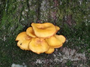
Welcome to the seventh Annual Mushroom Foray [thanks to both Springwater Trails and the Rochester Area Mycological Association] on Sunday, September 20, 2020, at the All Western Evergreen Farm. Three hiking groups are planned, all starting and ending at the parking area at the farm. We will explore much of the farm, enjoying views of the Christmas trees, forests, the valley and close-ups of the floral and mycological specimens.
Please plan to arrive early (1:45 PM) to sign in and to sign the RAMA liability forms.
Maps of the farm, paper bags and paper plates for collecting and displaying mushrooms will be provided. Those who want to learn how to collect mushrooms will be instructed by Gene and Georgia, and any other Rochester Area Mycological Association members who will be our guests.
The Climbers will follow the driveway up to the fields, and explore to the south and west, to explore the varied forests and Christmas tree plantations (Douglas-fir, Nordmann fir, Grand fir, Concolor fir, Canaan fir, Alaska yellow cedar, Norway Spruce, Meyer Spruce) for wild mushrooms up around the pond to Swartz Road and the Cathedral pines up to Story Road. Check out between the Christmas trees fenced off Story Road if you are looking for unusual mushrooms, back by way of the north field road, the giant Concolor fir in Scott Hill triangle and back through the Christmas trees (Fraser, Korean, and Concolor) that are fenced in UVW lots (the electricity will be turned off).
The Tourists will follow the driveway up through the woods, stopping occasionally to explore for mushrooms. When reaching saleable size Christmas trees (Lot Z), head to the right around or through the Christmas tree plantation. At the corner where the small Southwestern White Pine tree row ends and the tall Concolor fir are, follow the trail into the woods and back to the field and head west along the north field road to a hidden corner of the field with some spectacular 35 foot green and blue Concolor fir Christmas trees live, the size seen during Christmas season in a large mall. If there is still time, follow the north field road next to the hedge row up to Story Road along the tillable land that is rented or in the Conservation Reserve Program, along Story Road, the F Lot to the south field road and the Cathedral pines and back to the house through the woods.
The Naturalists will start exploring under and behind the Western red cedars (thuja plicata or giant arborvitae) by the parking area and south to the Alaska yellow cedar, large Concolor fir and spruce, then back up through the woods to the right of the trail up to the main fields. These are likely full of mushrooms, but you will find some swampy areas, so don’t get lost behind people’s homes along Liberty Pole.
All hikers should check their watches and return to the parking area by 4:00 PM to have their collections identified. A portapotty with a sink is nearby.
Mushroom Identification
Once again we are fortunate to have several RAMA members (Randy Weidner, Don Tuminelli, Eugene & Georgia Binder) with us who have volunteered to identify the mushrooms collected between 4 and 5 PM. After the mushrooms are identified please join us for a social (5:00 – 6:30 PM) hosted by Katherine outside the house next to the Furnace Building. She has offered to make Take-out Soup to be available in individual covered containers by donation. Please bring a lawn chair and your own bag lunch and beverage.
We will begin all the hikes at 6840 Liberty Pole Road where there is ample parking at the Christmas tree loading area between the tall Western redcedar and Morton Building and Nursery beds. Follow the parking signs. When we return from our foray, the mushrooms will be displayed for identification on paper plates on the tables outdoors. Please dress for the weather, rain gear as needed. Social distancing and masks are recommended when close together.
From Springwater: Go west from the Springwater light on NY-15 North. Just past the top of the hill and after rounding the tight curve, turn left on CR 38 (Liberty Pole Road). The farm is on the left (the high side) 1.1 miles from NY-15 at 6840 Liberty Pole Road after you cross Carney Hollow Rd. There is a sign for the All Western Evergreen Nursery & Christmas Tree Farm. Follow the orange cones to the parking area and park facing the house.
From Geneseo: Go south on NY-63. About 6.4 miles after passing NY-408, turn left on CR-1 (Groveland Scottsburg Rd) at Groveland Station. This road becomes CR 1A (Springwater Scottsburg Rd) at Scottsburg (Route 256) and then Liberty Pole Road after you cross Stagecoach Road (CR 71), and finally CR-38 (still Liberty Pole Rd) after crossing Reeds Corners Rd (CR-29). It is 7.1 miles from Groveland Station to All Western Evergreen Farm. The farm is on the right (the high side). Follow the orange cones to the parking area and park facing the house.
From Honeoye: Take 20A west to Hemlock and 15A south to Springwater. Then follow the Springwater directions above.
From Rochester: Take I-390S from Rochester. Use Exit 9 for NY-15 Lakeville. Turn left onto NY-15. Stay on NY-15 for 16.5 miles, through Lakeville, Livonia, Conesus and Webster Crossing. When NY-15 curves to the left at the south end of Webster Crossing, continue straight onto CR-60 (Carney Hollow Rd) and take the first right onto Liberty Pole Rd. The farm is on the left (the high side) at 6840 Liberty Pole Rd. Follow the orange cones to the parking area and park facing the house.
If using GPS, use the map directions on the www.allwesterntrees.com website and make sure you are on Liberty Pole Road and not being directed to the center of the farm from Swartz Road or Story Road. Follow the orange cones to the parking area and park facing the house.
Looking for brochure.or mailing list so I can receive it in the mail.
Nothing opens up for mailing list.
There’s all kinds of very bizarre ads and post for viagra and other drugs above on calender page.
Please let me know if there’s a brochure available