
Hikes led by Springwater Trails are generally held on Sunday afternoons and appear in this calendar in green.
| Sun | Mon | Tue | Wed | Thu | Fri | Sat |
|---|---|---|---|---|---|---|
| Lehigh Valley Trail Hike or Bike in Rush, NY 2:00 pm Lehigh Valley Trail Hike or Bike in Rush, NY @ Stevens-Connor Lehigh Valley Lodge Apr 6 @ 2:00 pm – 4:00 pm Come join us for a leisurely hike or bike along the Lehigh Valley Trail on Sunday April 6th! With its flat even surface, the trail is a hidden gem for walking, hiking, jogging, biking. It is a vital link in … Continue reading | ||||||
| Ontario County Park at Gannett Hill Hike-Naples 2:00 pm Ontario County Park at Gannett Hill Hike-Naples @ Lookout Parking area Apr 13 @ 2:00 pm – 4:00 pm  This is one of our group’s favorite hikes! Ontario County Park at Gannett Hill is one of the highest points in Ontario County and located in the scenic Bristol Hills. At an elevation of 2,256 feet above sea level, you’ll … Continue reading | ||||||
| No Hike-Easter Break 2:00 pm No Hike-Easter Break Apr 20 @ 2:00 pm – 4:00 pm No hike has been scheduled for this date due to the Easter Holiday. Enjoy the break, spend time with loved ones and eat chocolate bunnies. This will give you something to burn off next week  | ||||||
| Rob’s Trail – Hemlock Lake side 2:00 pm Rob’s Trail – Hemlock Lake side Apr 27 @ 2:00 pm – 4:00 pm Join us on Sunday April 27 to hike the west side of Rob’s Trail, the DEC/Nature Conservancy property in the northeast corner of Hemlock Lake. Options are to hike out and back to the south along the trail from the … Continue reading |

See hike description at https://www.fllt.org/events/30-for-30-anniversary-hike-at-the-wesley-hill-nature-preserve Event includes a dish-to-pass
get-together with grill at the end of the hike.
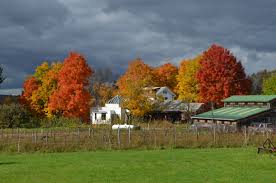
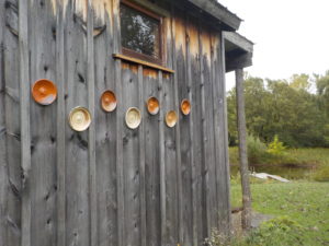
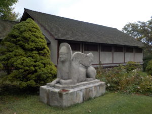 Sunday October 13 we will visit East Hill Farm, home of the Rochester Folk Art Guild, for a hike across a 350-acre hilltop farm and woodlot and a tour of the craft workshops. The Guild is a community of craftspeople, some resident and some visiting, and the weekend of October 12-13 is their annual fall Apple Festival and Open House, a celebration of the season with a home-cooked Farm lunch, local food vendors, fresh pressed cider, and tours/demonstrations at the pottery, wood, weaving and graphic arts studios. The Gallery/gift shop is also open for business. Admission is free, and the event runs until 5 PM. For event details see: Link here
To make sure you won’t miss out on the Guild’s acclaimed spread, please come by 1 PM for lunch before the hike. Others, please arrive by 1:45 to prepare for hiking at 2 PM. Hikes of 1.5 and 3.5 miles will allow for time to tour the workshops and Gallery afterwards. The Guild lunch menu includes homemade soups and salads, homemade bread and desserts, cider and coffee, for $12 total, or a-la-carte.
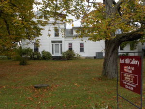
Please park on the road shoulder at 1445 Upper Hill Road, Middlesex (directions below). We will convene at the side of the East Hill Gallery, the first building on the left as you come in the driveway. Trails are gently sloped and well cleared, but may be muddy, and grass is ankle-deep in many areas, so wear good hiking shoes or rubber boots.
Climbers will head south through the Guild’s farm and neighboring properties, past a pond and sauna, through a spruce grove, and loop through woods and mowed fields to the “Golden Valley”, named for its spectacular fall color and views to the east. We will return through the woods and pass an eclectic array of residential buildings, workplaces and gathering places, designed and built by community members over their 50 years of occupancy at the East Hill Farm. Workshops will be open for Climbers to tour after the hike if they wish. Naturalists will make a shorter loop of about 1.5 miles, ending with a tour of the Guild buildings and the workshops.
Social: We will reconvene after 4 PM in the Dining Hall for a dessert-to-pass post-hike social. Some Guild food and desserts may still be available for purchase. Cider and coffee will be plentiful, or bring your own beverage.
Directions: from Springwater/Naples: Take Route 15 south to Wayland and Route 21 east/north to Naples. Turn right on Route 245 opposite Bob’s and Ruth’s Restaurant, at the north end of the village. Follow Route 245 north to Middlesex, about 8.75 miles. Turn right on Route 364 and go up the hill, one mile. Turn right on Upper Hill Road and go 1.5 miles. East Hill Farm will be on your left, at #1445. Park on the road shoulder and walk in the driveway to the Gallery/Dining Hall building, the white house on your left.
From Rochester and points north: Head to Routes 5 and 20 via Bloomfield or Canandaigua. At the east edge of the City of Canandaigua (first light after Wegmans/Post Office), turn south on Route NYS Route 364 (a.k.a. East Lake Road). Follow Route 364 south 12.5 miles to Middlesex, where 364 turns to the east and you will make a left onto Route 245 and then an immediate right to continue on 364. Go up the hill, one mile. Turn right on Upper Hill Road and go 1.5 miles. East Hill Farm will be on your left, at #1445. Park on the road shoulder and walk in the driveway to the Gallery/Dining Hall building, the white house on your left.
This month’s Finger Lakes Trail hike continues west toward Hornell in the Town of Howard. The trail is both pretty and pretty remote, and the day is predicted to be sunny with temperatures in the 60s. So a simple social is planned following the hike at the endpoint on Burleson Rd (a good dirt road). Bring lunch for yourself and if you wish, a desert to pass. Since cars will be left at the start of the hike, please plan to carry your lunch on the hike. And remember to bring water for hiking and the social.
This hike is on Map 10 between Access 9 and Access 7. All hikers will start from Hughes Road and hike west. This first section is on land owned by an archery hunter, who asks that we wear blaze orange during hunting season. The first section is mostly in the woods with intermittent views to the west. The trail is covered with leaves at this time of year, so watch the white blazes carefully. Depending on the size of the group, we will separate into two groups according to hiking speed. In 1.7 miles, the trail crosses Burleson Rd (a 200′ road walk to the left). From Burleson Rd, the climbers will follow a farm lane until we come to a pig farm. Follow the blazes to a bridge across the creek and then out to Stephens Gulch Rd. Please make sure the group leaves all gates as they found them.
The trail continues straight across the road, primarily on the seasonal Spencer Hill Rd to the top where wind turbines and views abound. However, watching our time, the Climbers will return back to Burleson Rd.
We will have cars waiting at Burleson Rd. We will find a nice spot along the road to enjoy the views and for a light picnic – bring a sandwich, extra liquid and if you wish, a desert to share.
Directions:
If you are willing to arrive 20 minutes early, please meet at the Burleson Rd trailhead (see below). We will carpool to the startOtherwise, here are directions to the start of the hike. We will start hiking at 2:00PM.
The following directions use I390 and I86 to get to Howard, NY. You can save about 5 minutes by taking Rt 21 south from Wayland, if you don’t get lost. Please note, there was construction on 415 south of Cohocton yesterday, requiring an easy detour.
From Springwater and Wayland: Head south on NY 15, through Wayland. Turn left to get onto I-390 south. Take the I-86 west exit toward Jamestown and take exit 35 for Howard, NY. Turn left from the exit, onto CR 70. Continue straight across CR70A onto Mill Rd. Bear left to stay on Mill Rd (don’t go straight onto Hopkins Rd) Continue straight at a small hamlet onto Craig Rd, then immediately turn right onto Hughes Rd. Hughes Rd will cross Turnpike Rd in 1.5 miles. Continue to the trail head on the right in 0.4 miles after Turnpike Rd.
From Naples: Head south on NY 21 to N. Cohocton. Continue straight on NY 371 to Cohocton. Turn right on NY-415 (Maple Ave). In 0.6 miles, turn left on Cohocton Loon Lake Rd and then left to get onto I-390 south. Take the I-86 west exit toward Jamestown and take exit 35 for Howard, NY. Turn left from the exit, onto CR 70. Continue straight across CR70A onto Mill Rd. Bear left to stay on Mill Rd (don’t go straight onto Hopkins Rd) Continue straight at a small hamlet onto Craig Rd, then immediately turn right onto Hughes Rd. Hughes Rd will cross Turnpike Rd in 1.5 miles. Continue to the trail head on the right in 0.4 miles after Turnpike Rd.
From Dansville: Take I390 toward Wayland. Continue on the Springwater directions above.
Directions to the end of the hike at Burleson Rd
From Springwater: Head south on NY 15, through Wayland. Turn left to get onto I-390 south. Take the I-86 west exit toward Jamestown and take exit 35 for Howard, NY. Turn left from the exit, onto CR 70. Turn right onto CR 70A.. In 0.4 miles, stay left (70A curves to the right) onto Graves Hill Rd (or maybe it is called Pfitzenmaier Rd or Starr Hill Rd) and then left on CR 27 (Stephens Gulch Rd). At the end (2.1 miles) turn right on Turnpike Rd, then a quick left onto Burleson Rd. The trail crosses the road in 1.5 miles. Park on the shoulder.
Directions from Burleson Rd to the start of the hike: Head north on Burleson back to Turnpike Rd. Turn right on Turnpike Rd. Continue straight for 0.8 miles, then turn right onto Hughes Rd. The trailhead is on the right in 0.4 miles.
This Sunday we return to Cleveland Hill at the back of Camp Cutler. This hike will provide a good climb and the resulting views of Naples Valley.
NOTE: Dogs are not allowed on this hike, except with the Naturalists.
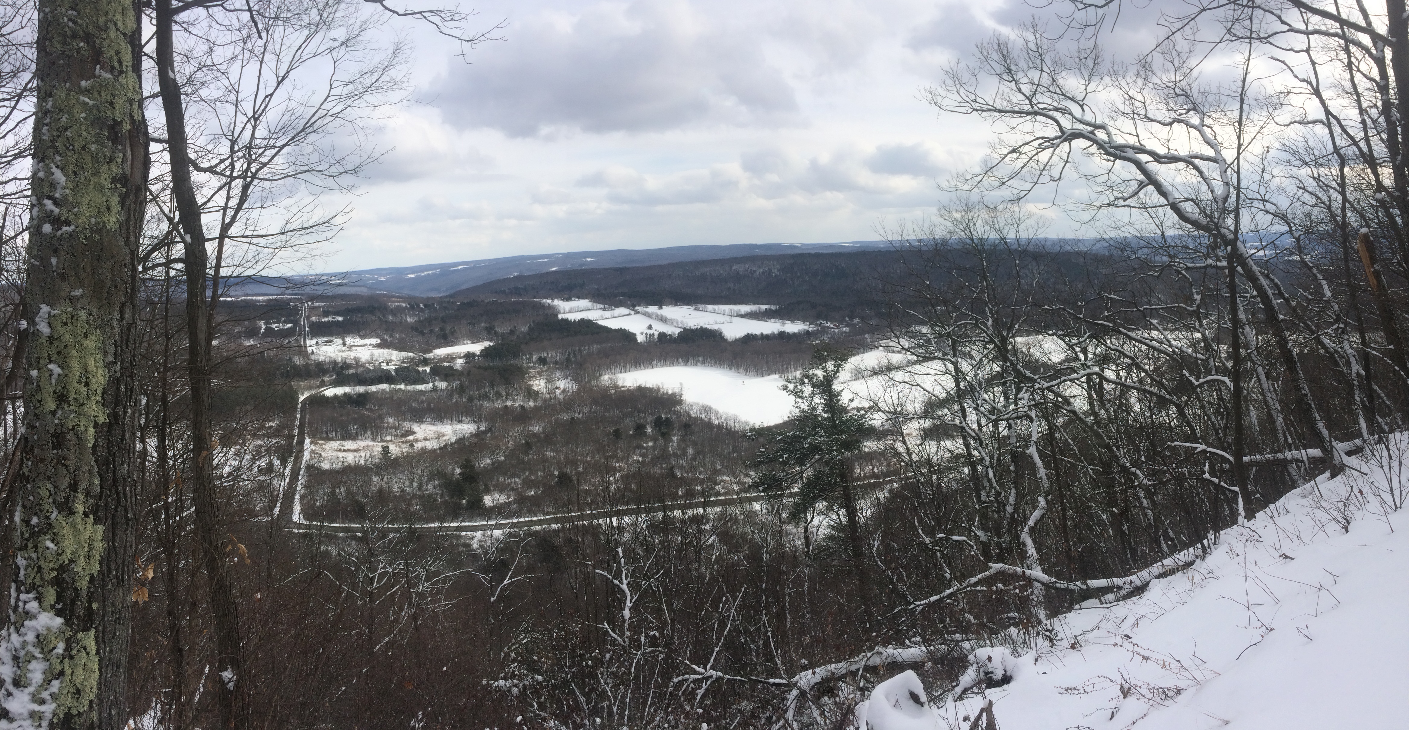
Click on picture for a high resolution panorama view.
The Climbers and Tourists will hike together. They will start at Cutler Rd and will enjoy a woods walk up Cleveland Hill through the Camp Warren Cutler boy scout camp and back down to West Hollow Rd (CR 33). This is a 3.1 mile hike. Meanwhile, the Naturalists will avoid the hill completely, and instead walk across CR 33 and hike a mile into the Beaver Pond before returning to the cars.
NOTE: The BHB trail is closed past the Beaver Pond for the fall hiking season.
All hikers will meet at the Camp Cutler parking area on West Hollow Rd (CR 33), to leave most cars at the end of the hike. The parking lot (42.6862, -77.417 or N42 41.1732 W77 25.0211) is on the west side of CR 33 about 1.8 miles north of Clement Rd, or 2.3 miles south of CR 34. From the parking lot, the Climbers and Tourists will carpool to the Clement Rd parking area (0.2 miles west of CR 33). The Naturalists will leave their cars in the parking lot, walk across the road and turn right for 200 feet to and follow the BHB trail to the east.
As you will see when you arrive at this hike, Cleveland Hill is quite high and steep. The climb is 400 vertical feet at each end. Fortunately, the trail has nice long switchbacks, so the slope is reasonable, but continues for nearly a mile. Plan on a steady climb with stops to catch your breath.
The Climbers and Tourists will carpool to Clement Rd (Turn right onto W Hollow Rd. Take the first right (1.8mi) on Clement Rd for 0.3mi. Park in the lot on the right). We will turn right coming out of the parking lot and walk on the road for a tenth of a mile. There is logging taking place near the trail and the initial road that we will walk on is rutted and muddy, but with some care you can avoid getting your boots very muddy. Turning right off the road and following the orange blazes, hikers will first pass a boy scout shelter, and then will turn right at the intersection with the white and blue trails. At several points on this hike, different boy scout trails will connect to the BHB trail, but we will stay on the orange trail for the entire route.The trail follows the east side of the hill, with at least one photo opportunity overlooking the West Hollow. After a mile along the top of the hill, a steep hike down will end at the original parking lot on CR 33.
The Naturalists will exit the parking lot and turn right to follow the road for 200 feet, where they will turn left to leave the road and cross the open field. They will follow a relatively flat trail for about an hour to the beaver pond. If time permits, there is a branch trail around the pond that can be explored. After the pond, the Naturalists will retrace their steps to the car.
As always, check the weather and dress appropriately. You will appreciate layers that can come off during the initial climb, and worn again at the top.
Following the hikes, please join us at the Neopolitan Pizza in Naples for food and socializing.
Directions:
From Springwater, (Wayland and Dansville): Take NY 15 South from Springwater to the light in Wayland. Turn left on NY 21 for 11.7 miles through N Cohocton (left turn) and into Naples (left turn at NY 53). Follow Main St for a half mile and turn left onto Vine St (the fourth left). Take an immediate right onto Race St following the sign “To CR 33”. Take the next left onto Cross Rd and then bear to the left onto West Hollow Rd. The parking lot is 4.7 miles ahead on the left.
From Honeoye: Head east on US 20A and turn right onto E. Lake Rd. In 0.6mi turn left onto Egype Valley Rd (CR 33). In 6.9 miles, turn right onto West Hollow Rd (stay on CR 33). The parking area is on the right in 2.3 miles.
From West Lake Rd south of Honeoye Lake: Follow West Lake Rd (CR 36) south, past Hunt Hollow ski area and past French Hill Rd. Turn left onto Gulick Rd. In 2.9 mi, turn right on Clement Rd. In a half mile, you will see the entrance to the BHB trail on the left, followed in a tenth mile, the parking lot also on the left. But keep going to the tee and turn left onto West Hollow Rd. The parking lot is on the left in 1.8 miles.
From Canandaigua: Take NY-21 south to the intersection with NY-64. Turn right onto NY 64 North for 2.3 miles. Turn left onto CR 34, then left onto CR 33 (West Hollow Rd). The parking area is on the right in 2.3 miles.
Directions to social at the Neopolitan:
From end of the hike on CR 33: Turn right (south) on CR 33. (be sure to stop at Clement Rd to pick Climber’s cars). In Naples, bear left onto Elizabeth St. Take the first right on Lyon St. The Restaurant is on the right at the intersection with Main St. Turn right onto Main St to park.
SPRINGWATER TRAILS HIKE FOR 2:00pm (try to arrive at 1:45PM), Nov.3rd , 2019
LOCATION: Stoneybrook State Park
HIKE DISCRIPTION: Hikers will split into three groups but essentially walk the same trail. Each group will walk at thier own pace. Climbers and Tourists will start from the snowmobile trail off RT 36 at the lower park entrance and climb along the eastern trail working thier way up to the upper park and then crossing over StoneyBrook Creek to the west side of the park and continue down to the lower park parking lot.
The Naturalists will car pool to the upper park and walk toward StoneyBrook Creek and cross over to the east trail and work their way down the snowmobile trial that the climbers and tourists climbed up. Once at the bottom, they will walk to the lower parking lot.
Most of the trail is up and down hill at the beginning and end of the hike but, levels off in the upper park. Trails are most likely going to be wet and slippery so poles and traction devices or good treaded hiking boots are recommended.
RECOMMENDATIONS: Dress accordingly, multiple thin layers(synthetic under layer, fleece 2nd layer. light shell 3rd layer; avoid heavy parka’s.
After hike social: Will be the Sunrise Restaurant on the North end of downtown Dansville.
DIRECTIONS : From Downtown Dansville take RT.36 South for about 4 miles. Turn left into Stony Brook State Park. Drive to the main parking lot where we will divide into our three groups.
The hike on Sunday November 10 2019 will be at the Wesley Hill Nature Preserve, a Finger Lakes Land Trust property. The Wesley Hill tract covers 390 acres and includes stands of northern hardwoods, red and white pines, a woodland pond, and the northern edge of Briggs Gully, as well as the Wenrich Cabin, set in an old forest overlooking the gully, deep in the woods. A network of trails through the preserve offers excellent hiking routes of various lengths and levels of difficulty.
 The preserve was founded in 1999 by the generous donation of 90 acres by the children of three artists – John Wenrich, James Havens and Colburn Dugan – to the Finger Lakes Land Trust. Since that time, the Land Trust has expanded Wesley Hill to over 390 acres through the purchase or donation of four additional parcels.
We will meet at 1:45 and start our hikes at 2 PM at the Gulick Road parking lot. This access point is on the west side of Gulick Road, 8.2 miles north of the junction with County Road 36 in Naples and 4.6 mile south of the junction with County Road 33 in Richmond.
This hike is being walked in hunting season, and many of the western trails are closed to hikers. Please respect all closure signs – there may be hunters out there and they won’t be expecting hikers in the woods. WEAR BRIGHT COLORS! Hunters can wander off course too; it’s important not to look like a deer!
The Hike:
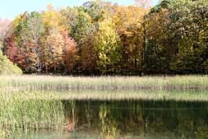
All hikers will start together on the red trail until we reach Anna’s pond (which is pictured above). Then….
NATURALISTS will walk around the pond as far as the trail allows, and then walk back to the start point. This is about 1 mile total.
TOURISTS will walk back to the junction with the green trail where they will turn right. They will follow the green trail about 0.2 miles to a junction of the returning red trail. They will turn left on the trail and walk 0.8 miles to the start point. The whole walk is about 1.6 miles.
CLIMBERS will take the red trail counter-clockwise around the tract. At the Wenrich cabin we will take a short extra walk to the overlook, and then back on the red trail to the start point. This hike as about 2.8 miles. If the weather is fine and we feel like walking a little extra we can turn right on the orange trail not long after we pass Anna’s Pond. This will take us on a loop through the northern parts of the tract until it ends at the yellow trail. Here we MUST turn left and follow the yellow trail back to the red trail to continue the hike. We will rejoin the red trail about 0.6 miles from where we left it. A right turn on the yellow trail would take us into hunting territory. If we take the orange trail then the total hike is about 3.8 miles.
The Social:
Following the hike, the optional social will be at the Neapolitan Pizzeria at 120 N. Main Street in Naples.
Directions to Gulick Road Trail Head:
From Honeoye take route 20A east through Honeoye to East Lake Road (CR-33). Turn right onto East Lake Road. Take first left, staying on CR33, then the first right onto Pinewood Hill which becomes Gulick Road. Travel 4.6 miles. The parking area is on the right.
From Springwater Head north on Rt 15A toward Hemlock. Just before Hemlock turn right on Rt 20A. Follow Rt 20A to Honeoye and the follow directions above.
From Naples From the southern end of Naples at the Middletown Tavern, head north on County Rd 36 (also called Hunt Hollow Road and Clark Street). Follow County Rd 36 for 1.2 miles to the first right turn on Gulick Road. Follow Gulick Rd for 8.2 miles. The parking area is on the left.
Directions to Neapolitan Pizzeria:
From the Gulick Road parking lot turn right and follow Gulick Road downhill until it ends at County Road 36. Turn left on County Road 36 (still going downhill) until this road ends at Naples Main Street (also called NY 21). Turn left. The Neapolitan Pizzeria is about half a mile away on the left hand side of the road, next to Artizan’s gift shop. It a fine Victorian house set back a little from the road.

FLT through Kanakadea Park. The FLT (shown in Black) is marked with White blazes on trees, signs or posts.
This Sunday we will follow the Finger Lakes Trail through the Kanakadea County Park west of Hornell. Last month we hiked south of Howard NY from Hughes Rd to Burleson Rd. The next section of the FLT starting at Spencer Hill Rd and ending on Lain Rd was led by Bill and Pam three years ago, and featured a social at the Cider Creek Cidery. In 2015, Linda led us on the section from Lower Glen Ave to North Hornell. For this FLT Series, we are going to skip to the west of Hornell and enjoy a recent route change for the FLT that takes advantage of park trails through Kanakadea Park. I will leave the previous two sections to leaders who would like to repeat a past hike.
A carpool to this hike will be available from the parking area behind the Firehall in Wayland. The carpool will leave promptly at 1:15. Following our hike, we will return to Wayland for a Social at the “Belt in the Eye” Diner.
All hikers will meet at the Parking lot in Kanakadea Park. The Climbers and Tourists will carpool a mile farther down Webbs Crossing Rd to a FLT trail-head parking lot.. We will assign leaders of the Climbers, Tourists and Naturalists at the hike depending on the requested groups.
NOTE: The portion of this hike south of the interstate is fairly flat and would be easy walking in dry conditions. With snow on the soft ground, walking will be slower and more difficult. Traction devices are encouraged, as are walking sticks. The section north of the interstate is a series of steep ups and downs. Special care to avoid slipping will be needed. In addition, the tunnel under the interstate is long and dark. A flashlight or headlamp is recommended for the Tourists and Climbers. As usual, dress in layers and carry water.

Naturalists will leave directly from the Park lot.
The Naturalists will start from the Park lot and head toward the lake to find white blazes for the FLT. Note that the road goes down to the water, while the trail stays along the edge of the high ground. Follow white blazes through wood and then up and across a field to the park’s Nature Trail. Once on the Nature Trail bear right to stay on the FLT. Once the trail comes out onto a field, hikers may decide to turn around and re-enter the Nature Trail. Following another section of the Nature Trail will return you to the parking area. Based on time, the Naturalists may follow the park road a short distance out of the parking lot, then turn left to continue on the FLT through the campgrounds. Naturalists are encouraged to leave the trail and explore near the lake.

The Tourists will cross Webbs Crossing Rd and follow the FLT within Kanakadea.
The Tourists will carpool to the FLT parking lot on Webbs Crossing. They will start with the Climbers heading out the back of the parking area uphill toward I-86. This will allow the Tourists to see the long tunnel under the highway before turning around and returning to the parking lot and starting to hike toward the Kanakedea Park. Carefully cross Webbs Crossing Rd and follow the white blazes on a mowed path parallel to the road. There is one section that isn’t blazed, but the trail goes to the left and is easy to follow to a gate to the park. (You can first go to the right and walk down to the lake – then return to the intersection and continue). Continue on the park road (there are occasional blazes on posts and the backs of signs). Turn right at the main park road and continue to the cars. As time permits, the Tourists can continue on the Naturalists route to the Nature Trail. [NOTE: If the tourists would prefer more climbing, but a shorter hike than the Climbers, they can follow the Climbers through the tunnel and around the loop, ending their hike at the FLT parking lot. If they do this, be sure to have keys to the cars so you can return to the park after the hike.
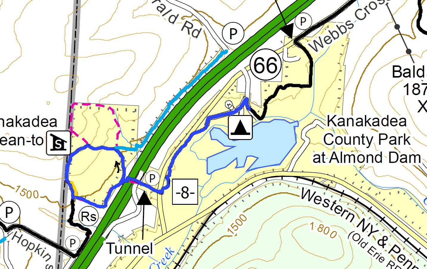
The Climbers will pass through the Tunnel and loop around back the the Tunnel, before following the Tourists through the park.
The Climbers will carpool with the Tourists to the FLT parking lot on Webbs Crossing. They will start uphill through the tunnel to the Senaca County Park on the other side of the highway. At the end of the fences, Climbers will turn right and follow the White blazed FLT. We will pass a Blue spur trail and later the Kanakadea Lean-to each on the right. About 0.3 miles after the Lean-To, we will see large yellow blazes and will leave the FLT when the yellow blazes go off to the left. After returning through the tunnel, we will follow the Tourist route to the Park and the waiting cars.
Directions to Carpool at Wayland Parking (42.568606, -77.590562):
Plan to be at the parking area at 1:00. We will leave at 1:15 for Hornell.
From Springwater: Head south on NY-15 to the light in Wayland. Turn right on Rt 63 (W Naples St). In about 150ft, turn right between the Fire House and the Sugar Creek building to get to the parking lot in the center of the block.
From Dansville: Head east on Rt 63 toward Wayland. Just before the second light in Wayland (at NY-15) turn left between the Fire House and the Sugar Creek building to get to the parking lot in the center of the block.
From Naples and N Cohocton: Head west on NY-21S toward Wayland. Go through the light at NY-15. In about 150ft, turn left between the Fire House and the Sugar Creek building to get to the parking lot in the center of the block.
Directions to Hike
From Springwater: Head south on NY-15. In Wayland, continue south on NY-21 and stay on 21 for 16.6 miles. Just before Hornell, turn right on CR 66 (Webbs Crossing Rd). (If you miss CR 66, turn right on Airport Rd, or NY-36 N and then take the first left onto CR-66). Continue for 2.5 miles. Turn left into Kanakadea Park. At the fork, stay to the left to the parking lot.
From Dansville: Head south on NY-36 past Stony Brook. In 14.5 miles, pass under I-86 and take the first right onto CR-36. In 2.2 miles, turn left into Kanakadea Park. At the fork, stay to the left to the parking lot.
From Naples and N Cohocton: Head south on NY-21S. In N Cohocton continue straight onto NY-371. At the stop sign in Cohocton, turn right onto Maple Ave. In a half mile, turn left onto Cohocton Loon Lake. Continue straight past the entrance to I-390 where the road becomes CR-121. In 4 miles, turn left onto NY-21. Just before Hornell, turn right on CR 66 (Webbs Crossing Rd). (If you miss CR 66, turn right on Airport Rd, or NY-36 N and then take the first left onto CR-66). Continue for 2.5 miles. Turn left into Kanakadea Park. At the fork, stay to the left to the parking lot.
Directions to Social
Head back toward Hornell on CR-66. Turn left onto NY-21N for 18 miles. In Wayland at the light, turn left on W Naples St, then right onto N Main St. The restaurant is on the right. You can park on Main St, or in the parking area where the carpool started. From the carpool parking, walk out the west entrance to Main St and turn left for the diner.
Mount Hope Cemetery in Rochester was dedicated in 1838 as the first municipal cemetery in the US. It was opened in response to the Cholera outbreak of 1831 to 1834. The location of the cemetery was selected for its challenging landscape, and was intended as a park-like cemetery to enhance the quality of life of the city residents. This hike will explore the hills, valley and heavily wooded areas of the cemetery in addition to visiting some of the well known graves including the graves of Susan B Anthony, Frederick Douglass, William Warfield and if we are fortunate, Harriet Hollister Spencer. You can read stories from Mt Hope Cemetery from the City Newspaper, and Wikipedia.
We have planned three separate hikes, which will be selected based on our turnout. All hikes will start at the North Gate entrance parking area in front of the 1862 chapel. You may download maps of the hikes here.
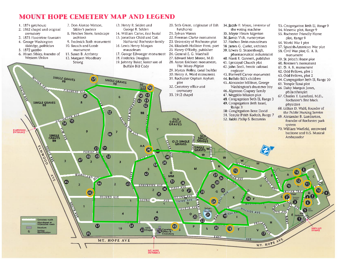 The Tourist hike will start by visiting the North end of the cemetery and Susan B Anthony’s grave-site. We will head up Linden Ave to Anthony’s grave near the corner with Maple Ave. The tourists will travel around the cemetery in a counterclockwise direction. In addition to the Anthony grave (11.), we will try to visit the following:
11. Susan B Anthony
6. Hiram Sibley
10. Bausch and Lomb monument (also look for mausoleums on Grove Ave).
12. Margaret Woodbury Strong
14 Earliest burial
15. Col Nathaniel Rochester
70. William Warfield
57&58. Civil War and Spanish American War plots
45. George Washington’s drummer boy – Alexander Milliner
69. Alexander Lamberton
18 Frederick Douglass
24. Elizabeth Hollister Frost
The Climbers will head up the hill on Lawn Ave to the right of the entrance toward Frederick Douglass’ grave. We will travel around the cemetery in a clockwise direction, Expect more hill climbing on this hike, as we explore the geologic feature of the cemetery. In addition, we will check out the following historic sites:
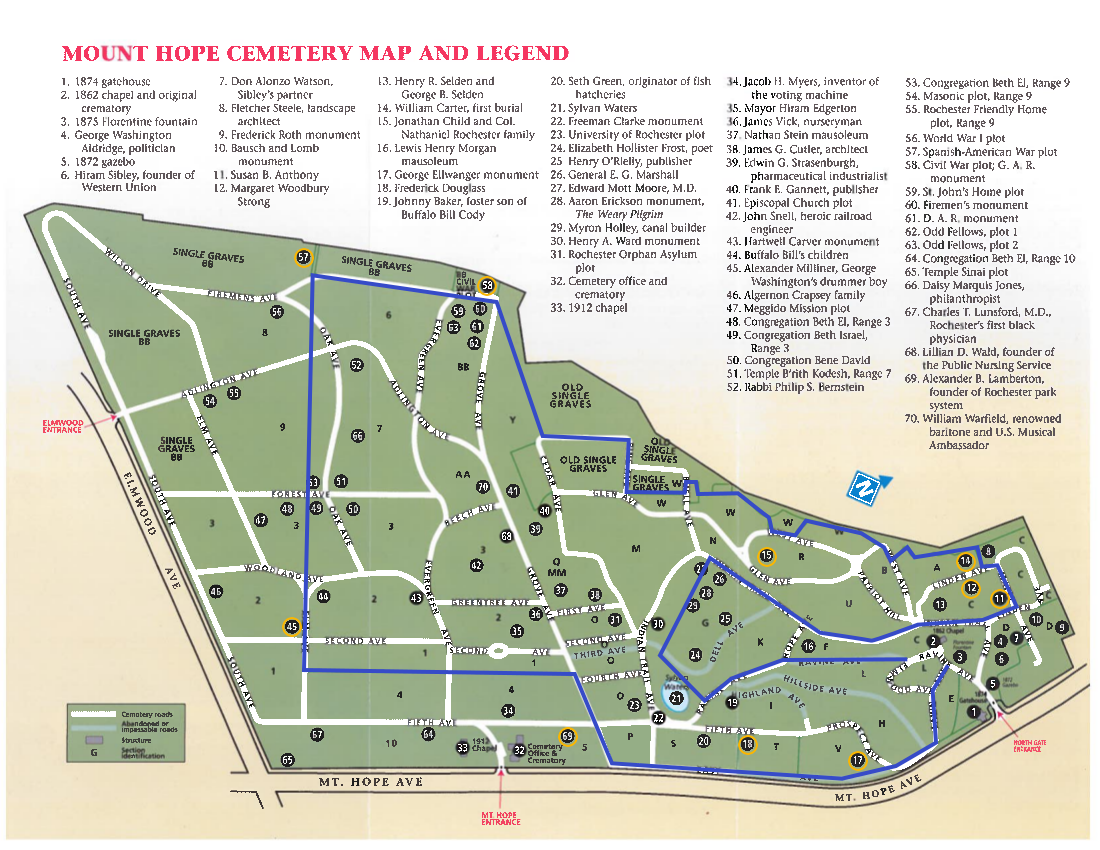 17. George Ellwanger monument
18. Frederick Douglass
69. Alexander Lamberton
45. Alexander Milliner, George Washington’s drummer boy
57 & 58: Spanish American and Civil War plots
70. William Warfield
24. Elizabeth Hollister Frost, and maybe Harriet Hollister Spencer
15. Col Rochester
14. First Burial
12. Margaret Woodbury Strong
11. Susan B Anthony
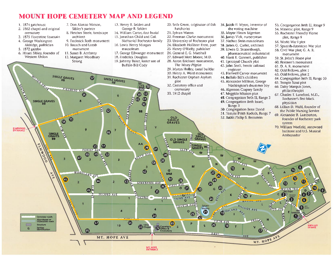 The Naturalists will head to the south end of the cemetery where they can explore as much as desired. But be sure to watch the time and head back along Indian Trail Ave to the north end and the Susan B Anthony site. The route plan will go past several interesting sites:
69. Alexander Lamberton
46. Algernon Crapsey
70. William Warfield
26. General E. G. Marshall
12. Margaret Woodbury Strong
11. Susan B Anthony
6. Hiram Sibley
10. Bausch and Lomb monument
Following our hike, join us for a social at the The Distillery – Sports Bar & Grill, 1142 Mt. Hope Ave, a half mile south of the cemetery entrance.
Directions
Mt Hope Cemetery is 47 minutes north of Springwater, so car pooling is recommended. Leave a comment on here on the website to plan carpooling. Good places to meet would be the Springwater Town Hall, Hemlock Lake Park at the north end of the lake, or Sandy Hook in Honeoye.
From Springwater: Head north on NY 15A for 19 miles to Lima. Turn left on US-20 for 4.2 miles. Turn right onto I-390 N. At the split with 590, stay left on I-390 and then stay right to exit 16B for NY 15A/E Henrietta Rd. Continue straight past South Ave and turn right onto Mt Hope Ave. Go up and over the hill for 1.8 miles to the second entrance to the Cemetery. There is parking inside the entrance.
From Naples: Take CR-36 (West Lake Rd) to Honeoye. Turn left on US-20A. In 5 miles turn right onto NY-15A and follow the Springwater directions.
Looking for brochure.or mailing list so I can receive it in the mail.
Nothing opens up for mailing list.
There’s all kinds of very bizarre ads and post for viagra and other drugs above on calender page.
Please let me know if there’s a brochure available