
Hikes led by Springwater Trails are generally held on Sunday afternoons and appear in this calendar in green.
| Sun | Mon | Tue | Wed | Thu | Fri | Sat |
|---|---|---|---|---|---|---|
| Lehigh Valley Trail Hike or Bike in Rush, NY 2:00 pm Lehigh Valley Trail Hike or Bike in Rush, NY @ Stevens-Connor Lehigh Valley Lodge Apr 6 @ 2:00 pm – 4:00 pm Come join us for a leisurely hike or bike along the Lehigh Valley Trail on Sunday April 6th! With its flat even surface, the trail is a hidden gem for walking, hiking, jogging, biking. It is a vital link in … Continue reading | ||||||
| Ontario County Park at Gannett Hill Hike-Naples 2:00 pm Ontario County Park at Gannett Hill Hike-Naples @ Lookout Parking area Apr 13 @ 2:00 pm – 4:00 pm  This is one of our group’s favorite hikes! Ontario County Park at Gannett Hill is one of the highest points in Ontario County and located in the scenic Bristol Hills. At an elevation of 2,256 feet above sea level, you’ll … Continue reading | ||||||
| No Hike-Easter Break 2:00 pm No Hike-Easter Break Apr 20 @ 2:00 pm – 4:00 pm No hike has been scheduled for this date due to the Easter Holiday. Enjoy the break, spend time with loved ones and eat chocolate bunnies. This will give you something to burn off next week  | ||||||
| Hike Rob’s Trail – Hemlock Lake side 2:00 pm Hike Rob’s Trail – Hemlock Lake side Apr 27 @ 2:00 pm – 4:00 pm Join us on Sunday April 27th to hike the west side of Rob’s Trail, the DEC/Nature Conservancy property in the northeast corner of Hemlock Lake! Options are to hike out and back to the south along the trail from the … Continue reading |
 This week, Springwater Trails is starting a series of monthly hikes along the Letchworth Branch of the Finger Lakes Trail. This 25 mile long trail passes along the top of the Letchworth Gorge on the eastern side of the park. The trail is known for beautiful views of the gorge for a vantage point that is often unfamiliar to regular visitors to the Letchworth Park. In addition to the main gorge and the Genesee River, there are many small streams that cross the park from east to west, carving gullies that must be crossed by hikers. So, we will often experience detours from the edge of the Gorge where these gullies are steep and deep, eastward to the head of the gully where crossings are possible.
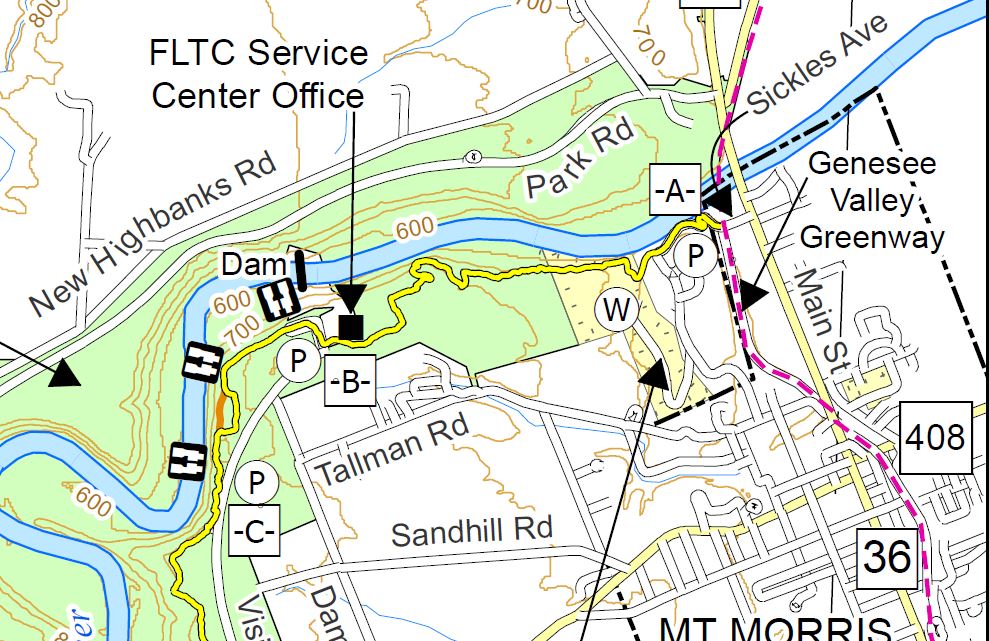
Our hike this Sunday will begin on the Greenway in Mt Morris. The Climbers will hike through the Al Lorenz County Park, past the Mt Morris Dam to Access C, a total of about 3.5 miles. The first half of the hike will be up a fairly steep hill to reach the flat area at the top of the gorge. The Tourist group will do the same hike in reverse – trading the steep climb for a steep descent. The Naturalists hike will be primarily flat. They will start at the Dam parking area and head north to the Wildlife Loop for a 1.5 mile hike. After returning to the parking area, the Naturalists may want to head south on the Letchworth Branch trail to enjoy some views of the gorge.
All hikers will meet at the parking area 400 feet north west of State St on Main St in Mt. Morris. Please come early to help arrange car pooling to Access Pt C at the south end of this week’s hike.
The Tourists will drive to Access Pt C (Hogsback overlook) to start their hike. After parking, they will immediately enjoy a view of the Letchworth Gorge. Turning to the right, they will follow the Letchworth Branch blazed yellow for about a mile to the Mt. Morris Dam Visitor Center parking lot. Yellow blazed are painted on the lamp posts down the center of the parking area, Continue across the parking area to the right corner of the visitor center where you will find a mowed trail heading diagonally across the field. On the far side of the field, continue to follow the yellow blazes. When you join the Wildlife loop, stay to the left to follow the yellow and blue blazes. The yellow blazes will leave the Wildlife loop to the left to start the descent along the gorge. After passing an old log cabin, you will see the pavilions of Al Lorenz County Park. Take the lane to the left up the hill to the Livingston County campus. Turn left on Sickles Rd and walk the road down around several switchbacks. At the bottom, the yellow blazes end at the Genesee Valley Greenway. Turn right on the Greenway and follow the trail beside the old Genesee Valley Canal to Main St and the awaiting cars.
The Naturalists will car pool to the Mt Morris Dam parking area to start their hike. If they arrive at the parking area before 4:30, they may want to spend a few minutes in the Visitor’s Center. Exiting the visitor center, turn left on the sidewalk and walk to the field. Follow the yellow blazes for the Letchworth Branch into the woods to the Wildlife Loop. Turn right onto the Wildlife loop, follow the blue blazes around until it rejoins the Letchworth Branch. Continue on the Blue/Yellow trail back to the start of the Wildlife Loop, then continue on the Yellow Letchworth Branch to return to the Visitor’s Center. Based on time, the Naturalists may want to spend time in the park around the Dam, or go to the South end of the parking lot and pick up the Letchworth Branch for a short out and back hike.
The Climbers will start from the meeting place along the sidewalk down hill to the Genesee Valley Greenway. Cross Main St and stay on the Greenway to Sickles Ave to the start of the Letchworth Branch of the FLT. Turn left and follow the road to the top. There are occasional blazes as you go up. At the top the road turns left but the trail continues straight (W) past a
dumpster on the right, down a lane to Al Lorenz County Park. Stay to the right to find the yellow blazes, into Letchworth Park, along the gorge. At the sign for the Wildlife Loop, stay on the Letchworth Branch. The trail will come out onto a mowed path to the Visitor Center, along the length of the parking lot, to a kiosk where the trail enters the woods and follows the gorge to Hogsback overlook (Access C). The climbers will then use the Tourist’s cars to return to the parking area (I hope you remembered to swap keys when you met the tourists on the hike up).
Following the Hike, we will all drive to Al Lorenz park for a pot luck social. Please bring a dish to pass and your own beverage. In case of rain, we will go to the Charred American Bar + Grill at 36 Main St across from the meeting area.
Directions to the meeting location:
From Springwater: Follow NY-15 N for 1.5 mile. Turn left on Liberty Pole Rd, which becomes Springwater-Scottsburg Rd, and Groveland Scottsburg Rd, for a total of 8.1 miles. Turn right onto NY-63 N. Turn left onto NY 408 into Mt. Morris. At the Main St light, turn right and park in the first parking area on the right (about 400 ft.).
From Wayland: Head south on NY-15. Turn right onto I-390 past the Dansville exits to Exit 36 (16.3 mi) for NY 36, Mt. Morris. Turn left on NY-36N for 5.2 miles onto Main St. The parking area is about 400 feet beyond the light at NY 408 on the right.
From Rochester: Take I-390 S to Exit 7 for NY 408 Mt Morris. Turn left (south-west) on NY 408. At the Main St light, turn right and park in the first parking area on the right (about 400 ft.).
Directions for carpools to the hike start: Turn left onto Main St. Take the second right on Chapell St (NY 408S) In 1.8 miles, turn right onto Visitor Center Rd. Tourists will stop in 1.1 miles at the Hogsback Overlook. Naturalists will stay on Visitor Center Rd for 1.7 miles to the parking log at the center.
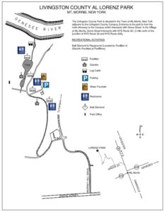 Directions to Al Lorenz Park:
From Main St Parking Lot: Turn right onto Main St. Turn left onto Grove St. Turn right onto Murray Hill Dr. Take the first left onto Al Lorenz Dr. Take the first right into the park.
From the Visitor Center parking lot: Turn right onto Visitor Center Rd. Take the first left onto Damsite Rd. Turn left onto Tallman Rd. In 1.2 mi, turn left into the park.
From Hogsback Overlook parking lot: Turn left onto Visitor Center Rd. Take the first right onto Damsite Rd. Turn left onto Tallman Rd. In 1.2 mi, turn left into the park.
A brief preview of the Springwater Trails Letchworth Series.
Our series of hikes will start at the northern end of the trail in the village of Mt Morris. The first hike (August) starts on the Greenway in Mt Morris to the Letchworth Branch intersection and upward past the Mt Morris Dam to Access C, a total of about 3.5 miles. In September, we will continue with a 4 mile hike to Access D, then 2.9 miles to Access E (Oct), 6 miles to Access F (Nov), 2.4 miles to Access G (Dec), 3.6 miles to Access H (Jan), 4 miles to Access K (Feb) and a final 3 miles (or so) in March to meet up with the main Finger Lakes Trail just past Portageville. The construction of a new railroad bridge over the Genesee at the south end of the trail has required re-routing of the Letchworth Branch onto road walks. We expect the trail to be reopened by March, but if necessary we will postpone our final hike until the trail is opened.
We will be hiking the original Rob’s Trail on Nature Conservancy land on the east side of Rt 15A, the connector trail down to Canadice Lake and the southern portion of the Canadice Lake Trail along the west side of the lake. Everyone should meet at the Rob’s Trail parking area just to the east of where Old Bald Hill Road South meets Route 15A in the Town of Canadice, Ontario County. Please come early to arrange for car pools. After the hike, we will have a social in the parking area. People attending the social should bring a dish to pass, their own beverage and something to sit on. In the case of rain we will go to the American Legion on Mill Street in Springwater for pizza.
There will be three different hikes with varying levels of difficulty. The three hikes will be:
- Up from Canadice Lake ~ 4 miles (the Climbers);
- Down to Canadice Lake ~ 4 miles (the Tourists);
- Along Canadice with no climbing ~ 2 miles (the Naturalists).
The Climbers and Naturalists will car pool from the parking area to the south end of Canadice Lake. Directions will be available at the start of the hike.
The Climbers will start at the south end of Canadice Lake and go along the lake trail to the Rob’s Trail connector trail and then continue around Rob’s trail to the parking area.
The Tourists will do the reverse hike, starting at the Rob’s Trail parking area. They will hike half way around Rob’s Trail and then descend to Canadice Lake, taking the lake trail out to the south end. They will use the Climbers cars to return to the parking area.
The Naturalists will do a flat hike next to Canadice Lake. This group will start with the Climbers and will walk for a mile or so along the lake trail and then return along the same trail to their cars.
Hikers wishing to complete the full 4 mile hike should consider whether they want to climb up Bald Hill or go down the hill. It is a 600 foot climb in 0.4 miles. The Climbers will be going up the hill and the Tourists will be going down (harder on the knees).
NOTE: Pets are not permitted on Nature Conservancy land at the top of Bald Hill. Hikers with dogs should go with the Naturalists or start with the Climbers and then join the Tourists when the two groups meet.
Directions: We will meet at the Rob’s Trail parking area on the east side of NY 15A (the entrance is actually on Old Bald Hill South. Directions are available here.
SPRINGWATERTRAILS HIKE FOR 4:00 pm (try to arrive at 3:55 PM), Sept. 2nd, 2018
LOCATION: Stony Brook State Park
Special Note: There is a seven dollar charge per car to enter the park. Anyone that would like to car pool to save the seven dollar charge can meet at 3:40 (leaving at 3:50 PM promptly) by the video store behind the Police/town hall station off Clara Barton street (Route 36) about 500 feet from the RT36 redlight on Main Street.
[envira-gallery id=”256245″]
HIKE DISCRIPTION: Hikers will split into three groups. Each group will walk at their own pace. Most of the climber trail is up and down hill, climbing at the beginning and down at the end of the hike. There are lots of steps to climb. Trails are most likely going to be wet and slippery so poles and traction devices or good treaded hiking boots are recommended. Tourists hike is flat or down hill until the East Rim trail where they will have to climb a short set of steps but then it is mostly down hill.
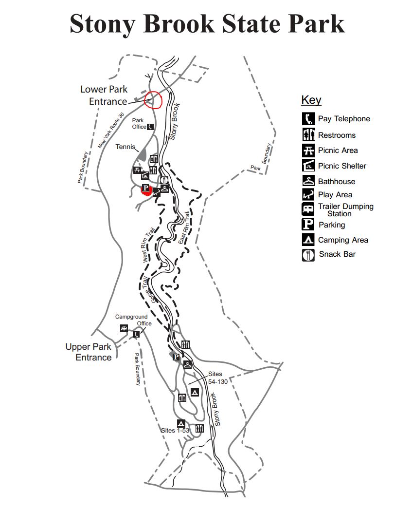 Climbers will start from the lower parking lot and climb the Gorge Trail starting at the swiming area and climb to the upper park crossing over the stone bridge and returning back to the lower park along the East Rim Trail.
The Tourists will car pool to the upper park and walk along a flat trail in the pines until they are just above camping sites 1-53. They will make thier way down through camp sites 1-53, 54-132 and 133-135 passing the playground and crossing over the stone bridge.They will return back to the lower parking lot via the East Rim trail.
Naturalist can stay in the lower park and enjoy the scenery along the creek area. The Gorge trail could also be walked for a short distance until the stairs are reached. There is a lot of climbing beyond this point.
RECOMMENDATIONS: The weatherman is calling for showers on Sunday so be prepared. That’s not as bad as the last Stony Brook hike when we had 20 inches of snow on the ground.
After hike social will be in the picnic area next to the lower parking lot. Bring a dish to pass or a five dollar donation would be appreciated. Hot dogs and Hamburgers will be provided.
DIRECTIONS: From Downtown Dansville take RT.36 South for about 4 miles. Turn left into StoneyBrook State Park. Drive to the main parking lot where we will divide into our three groups. The Tourists will car pool to the upper park to start their hike. Directions to the carpool location are also available.
This week we return to HiTor WMA above Naples. All hikers will meet at the parking area on Dewolf Rd. (A on the map below – click on the map to see a bigger version). Poles and good tread are recommended. There, we will break into our 3 groups.
The Climbers: Carpool to DEC entrance at Donley/Shay and Parish Rd (B). The initial entry is a grassy laneway that meets up with the blue trail near Conklin Gully. At the next trail intersection hikers will bear left onto the orange trail ascending to Brink Hill Rd. Once on Brink, turn left and follow the road to the stop sign, turn right, uphill to the end of Dewolf.
The Tourists will follow the FLT orange trail (C) on Brink Hill Rd to the blue trail on the grassy access road. We will then turn right and follow the access road along the edge of Parish Gully to the parking area on NY-245 near the intersection with Parish Hill Rd. Cars will be available to transport the tourists back up to their cars and the social. This hike is mostly downhill.
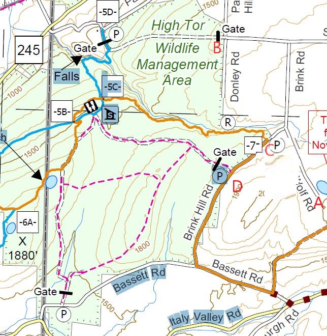 The Naturalists will enter High Tor 0.2 mile south of access 7, on a DEC access road (D). There is a For Sale sign on the property across from the DEC parking area. This hike will be an out and back, allowing the Naturalists to adjust the length of the hike to meet the wishes of the hikers. The road continues straight though the first intersection. At the second intersection, the naturalists should turn right to come to the lean-to and enjoy a long view of Canandaigua Lake. Bring your binoculars for Bird and duck spotting on the 2 ponds. From the lake view , turn around and follow the same road back to the cars.
Following the hike, join us for a social at Amy’s. The main dish will be provided. Please bring a dish to pass and your own beverage (or make a small $5 contribution to the social fund)
Directions from Naples:
From Naples/ Main St. travel SOUTH to join Rt. 53S, up the hill, away from town. Turn LEFT on Yates County Rd #21/ Italy Valley. Turn LEFT at the curve onto Bassett Rd. Church on opposite corner. Turn LEFT on Brink Hill Rd. Turn right onto Dewolf Rd at the stop sign. Follow the road to the top of the hill (A).
 We need someone to meet Amy at the Parish Hill parking area on Rt. 245 @ 1:30pm to leave a vehicle for the tourist’s return. Please comment or email Amy if you can do this. Thanks!
Note: An alternate route is possible from Rt 245 following Parish Hill Rd. Bear right at the curve to stay on Parish Hill then left on Shay Rd, first right on Brink Rd which turns into Dewolf Rd. A large portion of Parish Hill Rd is still dirt so the Bassett route is easier.
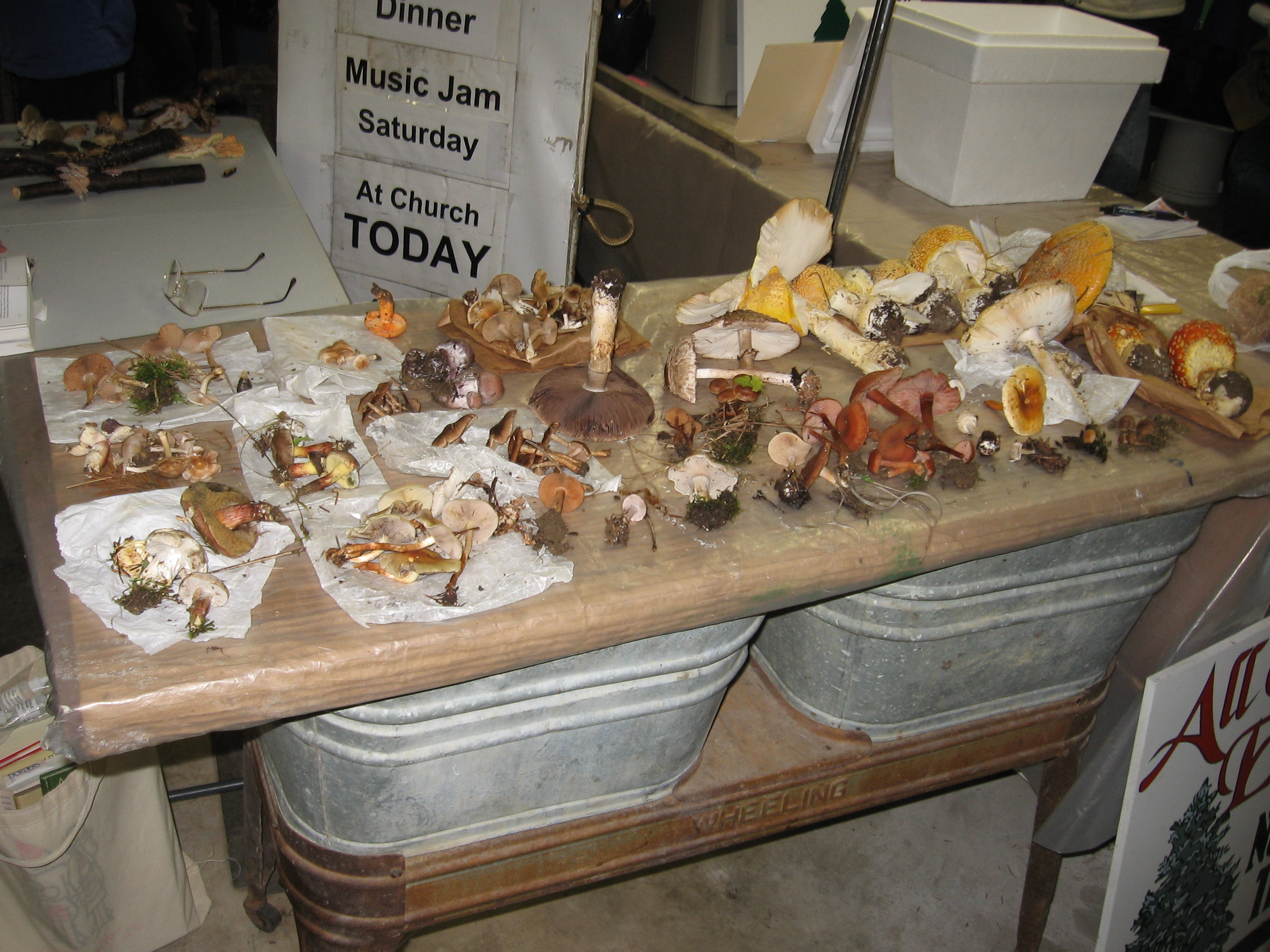
 Welcome to the Fifth Annual Mushroom Foray at the All Western Evergreen Farm. Three hiking groups are planned, all starting and ending at the farm house. We will explore much of the farm, enjoying views of the valley and close-ups of the floral and mycological specimens.
Please plan to arrive early (1:45) to sign in and to sign the RAMA liability forms.
Friendly dogs are welcome on the hike; however, a leash will be needed near the farm house and you can expect a few other dogs will be hiking with you.
Paper bags and paper plates for collecting and displaying mushrooms will be provided. Those who want to learn how to collect mushrooms will be instructed by Gene and Georgia, and any other Rochester Area Mycological Association members who will be our guests.
 The Climbers will follow the driveway up to the fields, and explore to the south and west, to explore the varied forests for wild mushrooms. Check out between the Christmas trees if you are looking for unusual mushrooms.
The Tourists will follow the driveway, stopping occasionally to explore the woods for mushrooms. When they reach the field, head to the right through several Christmas tree plantations.At the corner, follow the trail back into the woods. If time permits, return to the field and head west to a hidden corner of the field with some spectacular Christmas trees if you live in a large mall.
The Naturalists will start exploring under and behind the Red Cedars by the parking area. The woods to the right of the trail up to the main fields are likely full of mushrooms, but you will find some swampy areas, so don’t get lost.
All hikers should check their watches and return to the parking area by 4:00 to identify their collections.
Once again we are fortunate to have several RAMA members with us who have volunteered to identify the mushrooms collected between 4 and 4:30 p.m. After identification of the mushrooms, join us for a social (4:30 – 6:30 p.m.) hosted by Katherine at her house. Katherine will make two soups – Enchilada Chicken Soup and Vegetable Barley Soup. Please bring a dish-to-pass or make a small contribution to support the socials. Bring your own beverage. Dogs will want to stay in your car during the social.
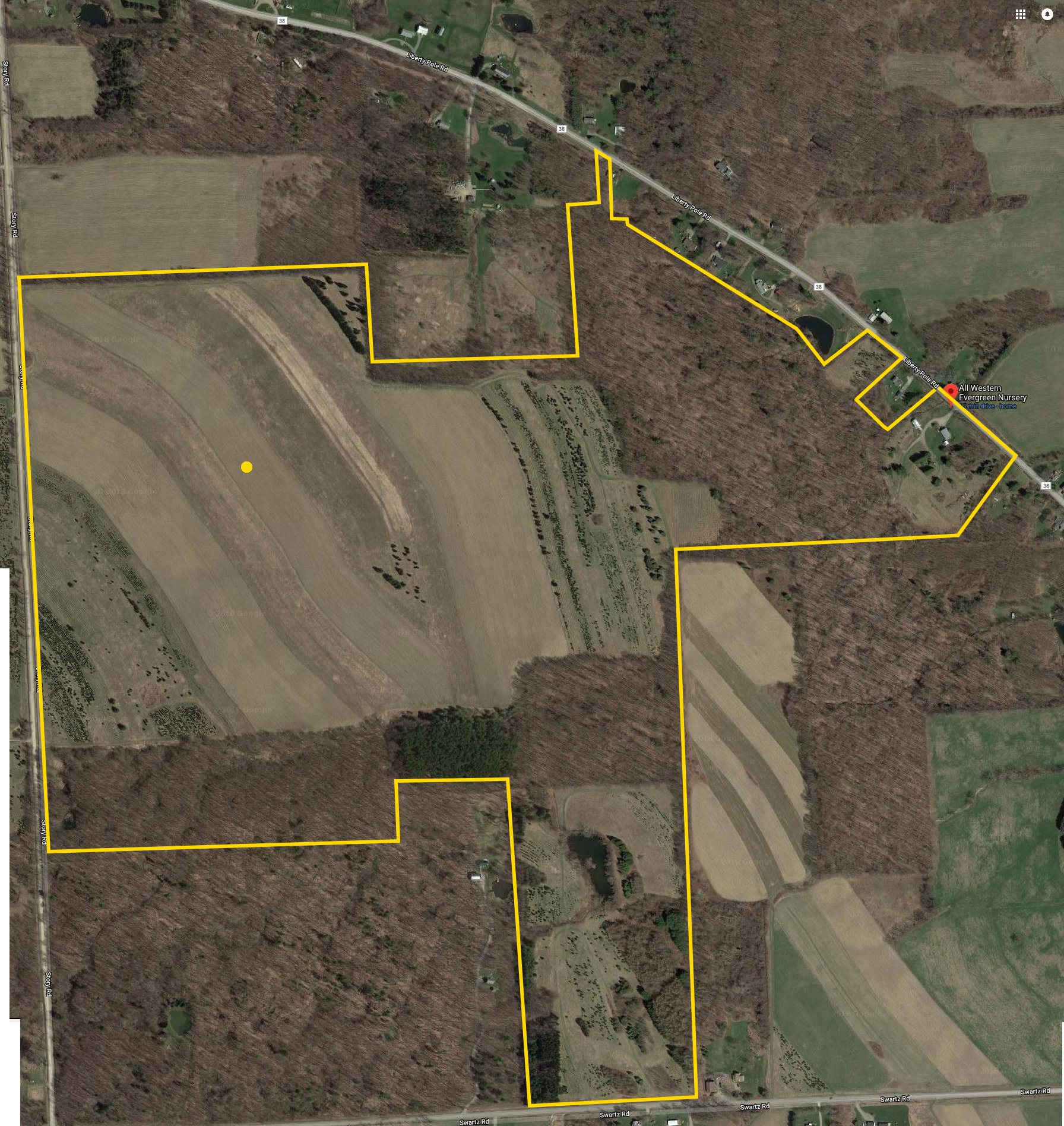
We will begin all the hikes at 6840 Liberty Pole Road where there is ample parking at the Christmas tree loading area between the tall Western redcedar and Morton Building and Nursery beds. Follow the parking signs. When we return from our foray, the mushrooms will be displayed for identification on paper plates on the tables indoors in the Morton Building or the basement depending on the weather.
If using GPS, please try 6840 Liberty Pole Road, Dansville, NY 14437 (the mailing address) so as to not have a problem.
From Springwater: Go west from the Springwater light on NY-15 North. Just past the top of the hill and after rounding the tight curve, turn left on CR 38 (Liberty Pole Road). The farm is on the left (the high side) 1.1 miles from NY-15 at 6840 Liberty Pole Road after you cross Carney Hollow Rd. There is a sign for the All Western Evergreen Nursery.
From Geneseo: Go south on NY-63. About 6.4 miles after passing NY-408, turn left on CR-1 (Groveland Scottsburg Rd) at Groveland Station. This road becomes CR 1A (Springwater Scottsburg Rd) at Scottsburg (Route 256) and then Liberty Pole Road after you cross Stagecoach Road (CR 71), and finally CR-38 (still Liberty Pole Rd) after crossing Reeds Corners Rd (CR-29). It is 7.1 miles from Groveland Station to All Western Evergreen Farm. The farm is on the right (the high side).
From Honeoye: Take 20A west to Hemlock and 15A south to Springwater. Then follow the Springwater directions above.
From Rochester: Take I-390S from Rochester. Use Exit 9 for NY-15 Lakeville. Turn left onto NY-15. Stay on NY-15 for 16.5 miles, through Lakeville, Livonia, Conesus and Websters Crossing. When NY-15 curves to the left, turn right onto CR-60 (Carney Hollow Rd). Take the first right onto Liberty Pole Rd. The farm is on the left (the high side).
This Sunday, Springwater Trails is hosting the fifth annual tri-modal hike around Canadice Lake. Bring your bike, your kayak and walking shoes and celebrate one of the two undeveloped Finger Lakes. Canadice Lake is unique among the Finger Lakes with a road and trail around the entire lake at water level. We will enjoy this trail on Sunday on foot and bicycle, and will add in some kayaking to complete the tri-modal event.
There are four hikes planned, depending on the interests of the participants.
Tri-modal: We will start on our bikes, traveling north from the Canoe Launch along Canadice Lake Rd. At the north west corner of the lake, we will enter the trail and continue around the lake, returning to the Canoe Launch. From there, it will be a short kayak across the lake, where we will leave our boats and hike north on the trail, planning to turn around at the Rob’s Trail bridge. Finally, we will return across the lake in our boats.
Bi-modal Climbers: The climbers will start in kayaks and spend about an hour on the lake, ending at the west side of the lake. They will beach their boats, leaving their paddles and life jackets in the boats, and turn left on the trail to hike around the south end of the lake and back to the Canoe Launch.
Bi-modal Tourists: The tourists will do the reverse hike of the climbers. They will carpool with the Naturalists to the south end of the lake, and then hike in to where the Climbers have left their boats. This hike will be slightly more than an hour, giving time to check the fall flowers near the trail. The Tourists will use the Climber’s kayaks to return across the lake to the Canoe Launch.
Naturalist Hikers: Hikers are invited to join the Naturalists for a hike along the Canadice Trail. Hikers will carpool to the southern entrance to the trail, and will hike for one hour, and then turn around and return to the cars and the Canoe Launch.
Following the hike, join us for a pot luck social at the Canoe Launch. We will grill hot-dogs. Please bring a dish to pass and your own beverage or make a donation to the social fund.
NOTE: Some of you may have noted that our plans depend on equal numbers of Climbers and Tourists. This may require some flexibility on your part and adjustments on the precise routes.
So, dust off your bike, load up your car and come enjoy a sunny fall afternoon on Canadice Lake.
Directions: All participants should meet at the Canoe Launch near the south end of Canadice Lake. Please arrive early enough to unload your boat and bike and stage them for the start of the event.
NOTE: the Canoe Launch is 1.5 miles south of the motor boat launch site.
From Springwater: Purcell Hill access: Go North on 15A for 7.6 miles. Turn right on Purcell Hill. At the end of Purcell Hill Rd, turn right onto Canadice Lake Rd on the east side of the lake. The Canoe Launch is 2.9 miles south.
From Springwater: Johnson Hill access: Go North on 15A for 2.7 miles. Bear right on Old Bald Hill Rd S and then an immediate right on Johnson Hill Rd. Take the first left onto Canadice Lake Rd. The Canadice Canoe Launch is 1.8 miles north of Johnson Hill Rd.
From Honeoye: Take Co Rd 37 South from 20A, Turn right after 3.7mi to stay on Co Rd 37. Stay straight onto Burch Hill Rd. At the lake, turn left onto Canadice Lake Rd. The Canadice Canoe Launch is 2.1 miles south of Burch Hill Rd.
From Hemlock and Rochester: Take NY Rt 15A south from Rochester through Lima and Hemlock. Just past Hemlock, Rt 20A goes left. Continue straight on 15A for 3,2 miles after 20A. Turn left on Purcell Hill. At the end of Purcell Hill Rd, turn right onto Canadice Lake Rd on the east side of the lake. The Canoe Launch is 2.9 miles south.
Please obey the No Parking signs at the launch area.
Boughton Park is located in the northern part of the Town of East Bloomfield, Ontario County. From the 1920s to the 1980s Fairport used the two reservoirs at this location for their water supply. We will have three hikes around these old reservoirs (now often referred to as “ponds”), one of which will be “accessible” to hikers on a scooter. The trails are good with very mild elevation changes. There is poison ivy beside the trails. If you stick to the trails you are okay, but be sure you can identify it if you get off trail. It is often just beside the trails, but not on them.
Carpooling: Parking (by permit only) is available at the trail head, but we are limited to 10 parking permits. Please plan to carpool, to preserve both gas and parking spots. Unsupervised carpools will start from the Springwater Town Hall or from the Sandy Bottom parking area at the north end of Honeoye Lake. Plan to arrive at Sandy Bottom at 1:15 to leave promptly at 1:25 for the hike. Or meet at the Springwater Town Hall at 1:00 to leave promptly at 1:10.
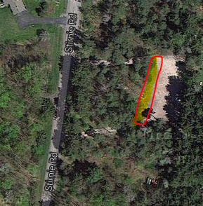 Hike Meet Location: All hikers will meet at the Stirnie Road parking lot. Please park at the Stirnie Road entrance, where the pavilion is located. We will have parking permits when you arrive – so please be on time! For clarity there is another parking lot off Boughton Rd, which we are NOT using as our “hike meet location”.
Optional After-Hike Social: We are planning a social at the pavilion near the parking. Please bring a dish to pass and your own beverage.
Hike Plans:  Boughton Park consists of 330 acres and 5 miles of designated trails. The area has some rolling hills with perhaps 50-100 foot max elevation change. The park is reserved for residents of Victor, East Bloomfield and West Bloomfield and their guests. On Sunday, Springwater Trails will be guests. For more information, click on the Boughton Park link.
The Victor Hiking Trails Seneca Trail connects to the north end of Boughton Park and from there, you can hike all the way through Victor to Perinton and the Crescent Trail. The section from Boughton Park to the Apple Farm is closed during hunting season, so we will stay within the Park boundaries.
 Hike Routes: For a larger map, click on the map or check the board at the trailhead.
Climbers: Climbers will hike around both ponds, (including a new loop at the southwest corner), then north along the west pond, to the east pond, and south along the east side of this pond, followed by the gravel road back to the north end, and along the west pond back to the pavilion, this is about 4 miles.
Tourists: Tourists can keep it to 2 miles by making a loop around the west pond only.
Naturalists: Naturalists can make the easy hike north to views of the west pond, then on the gravel road to the west pond, and return to the pavilion, 1 mile total.
Directions: To carpool locations
Springwater Town Hall: Please be at the Springwater Town Hall at 1:00PM to carpool to Boughton Park. Click here for directions to the town hall. Remember, this is an unsupervised carpool and drivers will be leaving promptly at 1:10PM.
Sandy Bottom: If Honeoye is more convenient, please meet at Sandy Bottom on West Lake Rd at 1:15PM to carpool. Drivers should leave promptly at 1:25PM.
Directions: TO THE HIKE: Set your GPS to (42.937581, -77.441284) or to 1911 Stirnie Rd (parking is on the east side of the road).
From Honeoye and the Sandy Bottom Park (carpool location) :
– From Sandy Bottom, head north on West Lake Rd.
– Take Rt 20A east for 5.9 miles
– Turn left onto CR 2 for 1 mile, then continue straight onto Oakmount Rd (CR2 turns right).
– Turn left onto Rts 5&20 and travel 1 mile.
– Turn right onto NY-64
– In a half mile, turn right onto Eddy Rd.
– Take the first left onto CR 39 and continue onto CR 39 for 1.7 miles.
– Turn right onto Boughton Rd (CR 39 will continue to the left)
– Take the first left onto Stirnie Rd. The parking area is 0.8 miles ahead on the right. (past a curve to the right, and a curve to the left)
From Springwater and the Town Hall (carpool location):
–Take Rt 15A north from the flashing light in Springwater.
–Turn right onto Rt 20A toward Honeoye. After 4.0 miles
– Turn left on CR 37 to go north to West Bloomfield.
– Turn right onto Rts 5&20 east at the West Bloomfield Congregational Church.
– In 3.7 miles, turn left onto Cannan Rd, (its the first road that crosses US20 both left and right).
– Cross NY64 where the road becomes Bennett Rd.
– At the first road, turn right onto CR 39.
– At the right hand curve on CR39, take a slight left onto Boughton Rd
– Take the first left onto Stirnie Rd. (It’s a VERY VERY short travel on Boughton Rd) The parking area is 0.8 miles ahead on the right. (past a curve to the right, and a curve to the left)
From Rochester area:
– Take I490 East to the Victor Exit 29.
– Merge onto Rt 96 S into Victor.
– Turn right onto Maple Ave (Rt 444) (follow the sign to Bristol Mt).
– At the flashing light turn right onto Boughton Hill Rd (CR 41) (At Ganondagan)
– Take the 1st left onto Murray Rd.
– At the T, turn right onto Town Line Rd.
– Take the 1st left onto Stirnie Rd. The parking is on the left after 0.4 miles.
Hike or Bike at Keuka Bluff
Sunday, Oct. 7, 2-4 PM
Our event for Sunday Oct. 7th has hiking and bicycling options, starting and ending at Keuka Lake State Park, just east of Branchport, on the northwest fork of Keuka Lake. The park has a sandy beach area and boat launch as well as nice trails through the wooded slopes and gullies along the hillside. NOTE: Bow hunting is permitted within the park in October, so HIKERS PLEASE WEAR RED OR ORANGE OUTER GARMENTS FOR HIGH VISIBILITY.
Park Fee and Car Pooling – On weekends the park changes a vehicle fee of $7 per vehicle, regardless of age. There is no charge for people entering the park on foot or on a bicycle, and there is a scenic overlook on Route 54A, just west of Pepper Road, which is the park entry road. To minimize vehicle fees, people may rendezvous at the scenic overlook at 1:40 and hitch a short ride with others in the group. Bikers and pedestrians may leave cars there and ride or walk in, about a quarter mile.
Everyone will meet at 1:45 at the lakefront parking lot within the State Park. Turn right after the entry booth and go past the playground to the second lot. All Hikers will start out on the White Trail into the woods, stopping first at the secluded and charming Beddoe-Rose family burial plot dating from the early settlement period of Yates County (14 burials from 1815-1908). The White Trail leads to the upper park road, where camp sites are laid out in three loops. Following the road past the camp sites, hikers will take the Green Trail, Orange and Yellow Trails looping through the woods and along several small gullies, ending at the lakeside and boat launch area for a total of about 3 miles. Tourists may return to the parking area along the park road, while Climbers wanting more of a challenge can follow the Purple and Blue Trails looping back up the hill and down to the cars, for a total of about 4 miles. Naturalists can explore the White Trail and cemetery at their leisure, climbing as far as the Park Road and returning on the park road or the wooded Red or Blue Trails.
Trailheads are well marked, and trails are well maintained. Total elevation change for the full trail loop will be about 400 feet, while Naturalists and others sticking to the Red, White and Blue Trails will have about a 200 foot change. As always, keep an eye out for poison ivy along the trail sides and check yourself for ticks afterwards.
Cyclists will enjoy a lovely 14 mile circuit on rural roads down the center of Bluff Point and back up the lakeshore road on the west fork. From the park entry, we will go south on Pepper Road, east on Fingar Road, and turn south on Skyline Drive, riding along the ridge toward the center of Keuka Lake’s Y shape. At the end of the plateau, Skyline Drive turns east into the woods and provides a glimpse of the secluded Garrett Memorial Chapel, a small 1931 Norman Gothic chapel perched on the steep side of the lake bluff. (See http://www.garrettchapel.org/) Next is a scenic view of the south end of the lake, and then West Bluff Drive past the cottages of the west fork, back to the south entrance to the park and the cars. The roads are well paved, without marked shoulders but traffic is light.
Launching of canoes and kayaks is easy from the beach area, so paddling options are also available to group members if the weather is warm and calm.
Following the hike, the optional social will be at Deusy’s Restaurant at Reservoir Creek Golf Course, 8613 State Route 21, Naples, NY.
Directions:
From Springwater: Follow Route 15 South to Wayland, and 21 North to Naples, turning right on Route 53 South toward Prattsburgh. After about 1.5 miles, turn left on Italy Valley Road (a.k.a Ontario County Rd. 21, then Yates County Road 18). After about 6 miles, go right on Italy Hill Turnpike (C.R. 34). When it ends, take a left on Italy Hill Road, and soon after a right as Italy Hill Road (now C.R. 32) turns to the east. This will take you down the hill into Branchport. Continue straight through the Branchport intersection, and go 1.5 miles. Pass the scenic overlook (stop for car poolers) and make a right on Pepper Road, and then the first right into the State Park.
From Honeoye/points north and west: Go east on Routes 5 and 20 to Canandaigua. Pass Wegman’s, Walmart, etc and go up the hill, about 2 miles. Take a right on Route 247. Follow Route 247 through Rushville. About 3 miles past Rushville, Route 247 will join with Route 364. Follow 364 through Potter and past some flat valleys. About 4 miles past Potter, make a right on Guyanoga Road (follow road sign for Branchport). Guyanoga Road will take you to the Branchport intersection in 7 miles. Turn left at the intersection and go 1.5 miles up the hill. Pass the scenic overlook (stop for car poolers) and make a right on Pepper Road, and then the first right into the State Park.
Directions to the Social from the Park: return to Branchport, and go straight at the intersection onto Italy Hill Road. When it ends, turn left and the right onto Italy Hill Turnpike. When this ends, take a left on Italy Valley Road, to Route 53, the Naples-Prattsburgh Road. Go right on Route 53, and left on Route 21 to Reservoir Creek Golf Course and Deusy’s.
The Sunday hike on October 14th 2018 will cover several trails on Hatch Hill in Naples; the Fall colors should be at the finest for this hike. The hike will start at the Bob North bridge at the bottom of Ontario Street in Naples. There is a kiosk and a small parking lot there, and all groups will start at the same place. The Naturalists will walk along Matt’s Meander to the Naples Community Park and back, while the Tourist will walk south along Hatch Hill above the town to the south end of Naples. The Climbers will walk north on Hatch Hill to Conklin Gully. Both Tourists and Naturalists will walk back to the parking lot, while climbers will end up at the DEC parking area at the bottom of Conklin Gully and be shuttled back to Naples. Note: the last half mile of this hike is a very steep downhill, but it’s worth it; the are huge drops into the gully to the right of the trail, and wonderful view across the gully and down into it.
There is a DEC display board at the parking lot with a map of all the trails that meet there; all the day’s hiking trails are shown.
The social will take place at the Neapolitan Pizzeria in downtown Naples.
Naturalists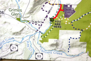

The Naturalists will cross Naples Creek on the Bob North bridge and bear to the left. It is a broad path through woods with the Naples Creek flowing to the left of the path. This trail is called “Matt’s Meander”, and it follows Naples Creek to the Community Park on Route 245. It is about a mile to the end of the trail and back.
Tourists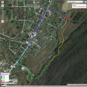

The tourists will cross the bridge and bear to the right. The trail runs south along Hatch Hill above Naples Creek, and goes parallel to both Naples Creek and Naples Main Street, though a lot higher up the hill. This path is not blazed or marked at all but it is well trodden for most of the way; it becomes a little harder to see at the southern end, but once the Turkey Federation parking lot is in sight then it’s not hard to find a way down to it. The trail passes through land that was once grazed and then terraced for vines, but is now returning to woodland. Traces of the shallow terracing for the vineyards can be seen all along the trail, and occasionally an abandoned farm building. The creek can be seen in the valley below the trail all the way along. This trail ends at the south end of Naples, on Mark Circle, where several streams come together to form the Naples Creek. There is water supply facility there, a swimming hole, and an antiques shop. The group will return to the Ontario Street parking lot via Naples Main Street. This walk is 2.1 miles. with just one short modestly steep section.
Climbers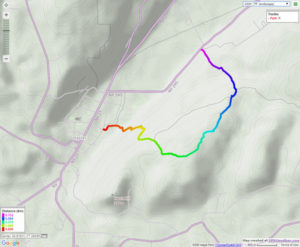
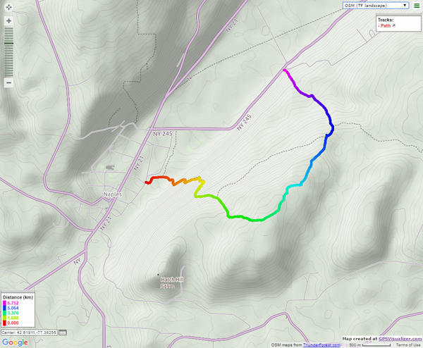
The Climbers will take the Finger Lakes Trail to Conklin Gully through the High Tor Game Management Area. They will cross the bridge and bear left along with the naturalists, and then about half way down Matt’s Meander the FLT branches off to the right. The group will follow the ORANGE blazes on a long uphill section; it’s steep in places with some switchbacks – the trail seems to be going the wrong way at times. There are some ponds at the top of the hill (it’s a mystery – where does that water come from?) with the Howard Beye memorial bench on one of them. It’s important to stay with the orange blazes here – there are several logging roads that make it easy to take the wrong path. Where the trail meets the top of Conklin Gully there is a lookout with a fine view of the Naples Valley and a well organized scout camp, complete with fire pit. The path down the hill from the camp is broad and easy walking. The group will leave the FLT where it branches off to the right over a bridge to the memory of Tom Noteware and follow the BLUE blazes down the hill to the DEC parking lot at the bottom of Parrish Hill.
The Meeting Place
We will meet at the trail head parking lot on Ontario Street, Naples, at 2:00pm on October 14th 2018. The climbers will shuttle some cars to Parrish Hill before starting off.
Getting There
From Springwater and Wayland, come south on Rt. 15 to the traffic light at Rt 21. Turn left on 21 and keep going all the way to Naples. Go through the downtown business area and turn right on Ontario Street, opposite the school. Go to the bottom of the hill and the parking lot is on the left.
From Dansville, follow Rt. 63 to Wayland where the road turns into Rt 21; continue on 21 all the way to Naples. Go through the downtown business area and turn right on Ontario Street, opposite the school. Go to the bottom of the hill and the parking lot is on the left.
From Naples, go to the school on Main Street (Rt. 21). Turn down Ontario Street opposite the school, go to the bottom of the hill and the parking lot is on the left.
The Social
The social will take place at the Neapolitan Pizzeria in downtown Naples.
Looking for brochure.or mailing list so I can receive it in the mail.
Nothing opens up for mailing list.
There’s all kinds of very bizarre ads and post for viagra and other drugs above on calender page.
Please let me know if there’s a brochure available