
Hikes led by Springwater Trails are generally held on Sunday afternoons and appear in this calendar in green.
| Sun | Mon | Tue | Wed | Thu | Fri | Sat |
|---|---|---|---|---|---|---|
| Lehigh Valley Trail Hike or Bike in Rush, NY 2:00 pm Lehigh Valley Trail Hike or Bike in Rush, NY @ Stevens-Connor Lehigh Valley Lodge Apr 6 @ 2:00 pm – 4:00 pm Come join us for a leisurely hike or bike along the Lehigh Valley Trail on Sunday April 6th! With its flat even surface, the trail is a hidden gem for walking, hiking, jogging, biking. It is a vital link in … Continue reading | ||||||
| Ontario County Park at Gannett Hill Hike-Naples 2:00 pm Ontario County Park at Gannett Hill Hike-Naples @ Lookout Parking area Apr 13 @ 2:00 pm – 4:00 pm  This is one of our group’s favorite hikes! Ontario County Park at Gannett Hill is one of the highest points in Ontario County and located in the scenic Bristol Hills. At an elevation of 2,256 feet above sea level, you’ll … Continue reading | ||||||
| No Hike-Easter Break 2:00 pm No Hike-Easter Break Apr 20 @ 2:00 pm – 4:00 pm No hike has been scheduled for this date due to the Easter Holiday. Enjoy the break, spend time with loved ones and eat chocolate bunnies. This will give you something to burn off next week  | ||||||
| Rob’s Trail – Hemlock Lake side 2:00 pm Rob’s Trail – Hemlock Lake side Apr 27 @ 2:00 pm – 4:00 pm Join us on Sunday April 27 to hike the west side of Rob’s Trail, the DEC/Nature Conservancy property in the northeast corner of Hemlock Lake. Options are to hike out and back to the south along the trail from the … Continue reading |
IMPORTANT UPDATE (posted Monday 7/17 ~12:40PM)!!! PLEASE NOTE RESCHEDULING OF THIS HIKE!!! – THE HIKE (ORIGINALLY SCHEDULED FOR MONDAY 7/17) HAS BEEN RESCHEDULED TO TUESDAY JULY 18TH (SAME TIME & PLACE). RESCHEDULING IS DUE TO WEATHER CONCERNS FOR MONDAY EVENING. ALL OTHER INFO REMAINS THE SAME.
FOR ANY POSSIBLE ADDITIONAL UPDATES – PLEASE CHECK THE FOGVG FACEBOOK PAGE.
**It should also be noted, subsequent to the hike, usually within a few days, often photos of the hike are posted on the FOGVG Facebook page.
An opportunity for a 7/17/2017 Monday hike, at Letchworth State Park, exists for ST hikers to join the members of Southern Tier Greenway Hiking group (STGH). STGH is made up of hikers who hike the southern section of the Genesee Valley Greenway State Park (GVGSP aka GVG) and many more locations. ST has hiked with some of these hikers during the Friends of Genesee Valley Greenway (FOGVG) annual event held in early November. And some STGH hikers have joined-in on some ST hikes. The information about this Letchworth hike is as follows.
Introductory info: – – Perhaps “motivation” to attend. – – “Trolleys at Twilight” is an annual event at NYMT. This event happens to be scheduled for Saturday, July 22 in 2017. Some ST hikers may recall that we in ST have synced at least two hikes at the Genesee River Reserve (a sprawling town park situated in the northwest corner of the town of Rush) with opportunities of NYMT whose main museum building is located near the northeastern corner of the Reserve. Impetus was expressed to do more ST hikes at the Reserve.
To date, ST has not synced a hike with “Trolleys at Twilight”. Perhaps that may be a distinct possibility for a future year. In the mean time here is an opportunity for ST hikers to avail themselves a unique opportunity, and perhaps “get the wheels turning” in consideration of planning a ST hike in sync with a scheduled NYMT “Trolleys at Twilight” future event. Any ST Hike Planner could meld a ST hike and NYMT “Trolleys at Twilight” event as a combo event opportunity, and likely a jump-starter to doing so would be to first experience “Trolleys at Twilight” first-hand.
A link to NYMT calendar of events, for edification and perhaps an impetus or prompt to a ST Hike Planner with an eye toward future hike combo event possibilities. (Note that Sept & Oct Sundays bring Fall Foliage trolley rides and Saturday 10/21 the Halloween Trolley Express, while December Sundays bring Holly Trolley rides. Merely some opportunity to plan a hike combo event for the ST Autumn hiking quarter, Oct-Dec.)
Topical Info: (provided by NYMT) Enjoy a unique evening at an old-time trolley park at the New York Museum of Transportation, Saturday, July 22, 2017 from 4:00 until dusk. Trolley rides will operate throughout the event and calliope music will waft through the air as the sun goes down over the scenic Genesee countryside. Complimentary ice cream treats will be provided for all attendees!
Trolley rides will operate continuously from 4 p.m. til dusk, and the museum model railroad will be alive with miniature trains. As the sun sets, there will be unique opportunities for night photography. No reservations are needed, and unlimited trolley rides are included in the admission price of $8 adults, $7 seniors age 65 +, and $6 youths age 3 – 12. Under age 3 are free.
The New York Museum of Transportation is located at 6393 East River Road, just 20 minutes from downtown Rochester and easily reached from Exit 11 off I-390. Phone: (585) 533-1113. The museum is regularly open only one day per week – Sundays from 11AM- 5PM, except for special events such as this Saturday special event “Trolleys at Twilight”. www.nymtmuseum.org
This Sunday, we will be hiking the Springwater Trail at Sugarbush Hollow.This will be a combination hike and maintenance day – our goal is to hike from Pardee Hollow south, over the hill and then west to Punky Hollow, cleaning fallen branches off the trail and noting any larger maintenance that can be completed at a future work day.
The Climbers will start from Sugarbush Hollow and will hike to Punky Hollow, and then return to the start point using the Orange trail on the route back. Tourists and Naturalists will carpool to the Punky Hollow end and will hike the opposite direction. The Naturalists will return to the start point at Punky Hollow, while the Tourists make the trek up and over the hill to the sugar house.
Following the hike, we will head to Atlanta and the Mountain View Inn for dinner and drinks.
Directions: Meet on Pardee Hollow downhill from the Sugar House at the entrances to the Trail. Detailed directions here.
An opportunity for a 7/25/2017 Tuesday hike, at Letchworth State Park (eastside of the park), exists for ST hikers to join the members of Southern Tier Greenway Hiking group (STGH). STGH is made up of hikers who hike the southern section of the Genesee Valley Greenway State Park (GVGSP aka GVG) and many more locations. ST has hiked with some of these hikers during the Friends of Genesee Valley Greenway (FOGVG) annual event held in early November. And some STGH hikers have joined-in on some ST hikes. The information about this Letchworth eastside hike is as follows.
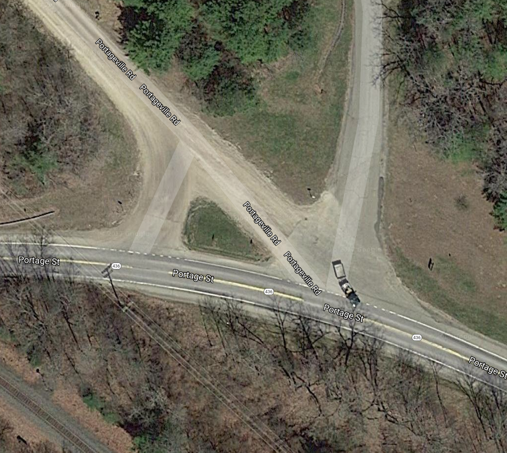
In this picture from Google Maps, you can see a car with a trailer coming out of the park entrance onto NY-436. This is where you should turn in.
Please note that the area consisting of the park entrance road (at Portageville Rd & NY Rt 436 aka Portage St) and immediate surrounds can be a bit confusing, in part due to an additional short spur between Portageville Rd & NY Rt 436. This short spur intersects NY Rt 436 at approx a 90 degree angle, vs the acute angle formed by NY Rt 436 & Portageville Rd / the park entrance road. google maps view
This Sunday, we will take advantage of Canadice Lake, the smaller of the two undeveloped Finger Lakes north of the town of Springwater. Prior to the purchase of the land around these lakes by the City of Rochester, Canadice was known as the lake with cottages for the “locals”, while Hemlock catered more to the city folk. Hikers should be able to see cottage foundations remaining on the west side of Canadice Lake. Take a look at photos of some of those cottages.
We will all meet at the Canoe Launch near the south end of Canadice Lake. Boaters should arrive by 3:30 to allow time to unload boats and transport them to the lake. Following the hike and boating, we will have a Dish to Pass social at the Canoe Launch. Bring a dish to pass or make a donation to the Social Fund. Also bring your own beverage.
HIKERS:
Naturalists and Tourists will car pool to the south trail entrance and will follow the trail to the west side of the lake and up the west side. Checking the time, they will turn around to return to the cars and the canoe launch at 6:00. Climbers preferring a longer one way trip, will car pool to the north end of Canadice and arrange for a ride back with the Naturalists at the end of the hike. This trail is wide and fairly flat, allowing all hikers to enjoy the lake.
BOATERS:
Boaters will launch from the Canoe Launch and will head South and then North along the western shoreline. They will head across the lake to return south to the canoe launch for a 4 or 5 mile trip.
DIRECTIONS:
From Springwater: Go North on 15A for 2.7 miles. Bear right on Old Bald Hill Rd S and then an immediate right on Johnson Hill Rd. Take the first left onto Canadice Lake Rd. The Canadice Canoe Launch is 1.8 miles north of Johnson Hill Rd.
From Honeoye: Take Co Rd 37 South from 20A, Turn right after 3.7mi to stay on Co Rd 37. Stay straight onto Burch Hill Rd. At the lake, turn left onto Canadice Lake Rd. The Canadice Canoe Launch is 2.1 miles south of Burch Hill Rd.
From Hemlock and Rochester: Take NY Rt 15A south from Rochester through Lima and Hemlock. Just past Hemlock, Rt 20A goes left. Continue straight on 15A for 3,2 miles after 20A. Turn left on Purcell Hill. At the end of Purcell Hill Rd, turn right onto Canadice Lake Rd on the east side of the lake. The Canoe Launch is 2.9 miles south.
**Please note, this hike is the last of three hikes that have been scheduled in weekly succession at Letchworth State Park by the Southern Tier Greenway Hiking (STGH) group with an interpreter provided. Subsequent weekly hikes that STGH has planned will be held on trails that are further south and west of Letchworth S.P. (At full disclosure, posting to the ST website for the previous two hikes was with only one day or so notice prior to each of those two hikes, so somewhat unfortunate in notice given for any interested hikers. However for this hike it has been posted 4+ days in advance.)
An opportunity for a 7/31/2017 Monday hike, at Letchworth State Park, exists for ST hikers to join the members of Southern Tier Greenway Hiking group (STGH). STGH is made up of hikers who hike the southern section of the Genesee Valley Greenway State Park (GVGSP aka GVG) and many more locations. ST has hiked with some of these hikers during the Friends of Genesee Valley Greenway (FOGVG) annual event held in early November. And some STGH hikers have joined-in on some ST hikes. The information about this Letchworth hike is as follows.
Join us for a hike at the Harriet Hollister Spencer State Recreation Area. Harriett was a Rochester horticulturist, rose expert and civic leader. Over 600 acres in the park was donated to New York State from her estate in the 1960’s. It is part of the New York State Park System. There is a panoramic view of the countryside from the Overlook Trail. Some folks take the long drive up just to gaze at Honeoye Lake and the surrounding hills from this two thousand foot high vantage point. On a clear day, the Rochester skyline is visible. For some this will be a familiar destination, for others an opportunity to explore a variety of trails through the forest with some intriguing terrain. As usual we will gather at the designated parking area to welcome everyone and to form our hiking groups. Maps will be provided to hike leaders.
Naturalists will head out on Ruthie’s Run to the Chalet Trail. This area is an old road that once led to a large chalet and cabins which housed a camp at one time. Two of the old red cabins are still standing. One is used by the Nordic Ski Patrol during the winter season. This group will continue on until the trail meets The Pines trail. There they will stroll through a lovely corridor of Norway Spruce, eventually arriving at the picnic area and restrooms. From there they can amble along Overlook Road to take in the scenic view for as long as they wish. A short half mile hike up the road or along the trail that parallels the road, will return them to the starting point. Total mileage about 2.5 miles. Hike leader to be recruited.
The Tourist group will follow the Overlook Road for a brief way to connect with Cannonball Run, a shady fern covered section of the woods. Where Cannonball meets the park road, the Tourists can stop to admire the outstanding view before proceeding on to Raccoon Run and the Blue Spruce Trail, an easy meander through the forest, with a few small hills to navigate. This group will return to the parking area via the Chalet Trail for a total of about 4 miles. Wendy will lead this group.
Climbers will tackle a number of trails, beginning at Big Oak, to hike around the perimeter of the park in a clockwise direction. This group will sample most of the park trails during their 5 + mile journey. They will also enjoy a stop at the famous Overlook. Hike leader to be recruited.
Social: Following the hike we will have a dish to pass social at the parking area. Bring a dish to pass or make a donation to the Social Fund. Also bring your own beverage.
Directions: From 1 mile north of Springwater on Rt. 15A, turn up Wheaton Hill RD. Drive all the way to Wetmore RD. and turn left. Continue straight onto Canadice Hill RD. and drive another 2 miles to the park on the right.
From Honeoye: Take County Road 37 and continue straight onto Canadice Hill Rd. to the park on the left..
Chimney Bluffs State Park, on the Lake Ontario southern shoreline in eastern Wayne County, just east of Sodus Bay is indeed a unique place, and a quintessential hiking destination. This locale is distant enough from the Springwater and surrounds area such that not likely that Springwater Trails (ST) would plan a hike here … due to the travel distance. BUT, HOLD ON, … for those interested in hiking this destination with a group of like minded hikers, well, Victor Hiking Trails (VHT) is leading a hike here on Saturday, August 12, 2017. All hikers are welcome. And of course, ST & VHT as organizations share numerous common bonds.
This hike will be a good opportunity to see this unique scenic area, and the erosion caused by the high levels of Lake Ontario that have been the case in this 2017 Spring & Summer season. Chimney Bluffs area is constantly changing due to the geological make-up of this place. Erosion is a constant here, and increased erosion in 2017 hastens the change and loss at Chimney Bluffs. The uniqueness of the area is always under constant change, and erosion eventually claims the various geologic formations here, … sometimes sooner rather than later.
Any updated details can be gleaned from the Victor Hiking Trails website.
The published basics of the hike are:
-
VHT will meet in the parking area behind the Victor Town Hall (85 East Main St) at 9am, and carpool to the hike.
-
Hike Chimney Bluffs State Park
On Saturday, August 12th, Victor Hiking Trails will lead a hike at Chimney Bluffs State Park in Wayne County, NY.
There are 4 miles of moderate trails through woods, meadows and along the shore of Lake Ontario. Comfortable hiking boots are recommended. Please, no pets on this hike.
Bring insect repellent, sunscreen, something to drink and a snack.We may stop for lunch on the way home.
Meet in the rear parking lot of Victor Town Hall, 85 East Main Street, at 9:00 A.M. to carpool to the trailhead. Or meet at the park entrance located at 7700 Garner Road, Wolcott, NY 14590 at 10:15 A.M. There is a $5.00/per car fee.
Check the website www.victorhikingtrails.org, Facebook, Meetup or the voice message line (234-8226), for additional details.
Genesee Valley Greenway (GVG) hike on Saturday, 8/12/2017. Series Hike #5—Fowlerville Road going north.
Historic Interpretive Hike Series (Wegmans Hike #5): Fowlerville Rd going north Saturday, August 12, 2017 10:00 AM GVG Parking Area Fowlerville Road, Town of York, NY. Meet at the parking area on the south side of Fowlerville Road (GPS: N42 53.505 W77 49.419) Starting at GVG mile 21, hike to just past mile 20 on easy, flat trail with a mixed surface. (2.7 miles total)
The guide will provide history of the Town of York and also point out historic canal and railroad features, including stone remaining from the Genesee Valley Canal Lock #5, and interesting natural features along the way. This hike is one of 14 hikes in the Wegmans Passport to Wellness Program. Completion of hikes in this series makes the trail user eligible for Wegmans grocery coupons or a NYS Parks Empire Passport. Passports will be available at the time of the hike and there will be an opportunity to complete the rubbing for this hike. Questions: fogvg@frontier.com or (585) 493-3600
Please note, that this section of trail contains a mixed surface, … one segment is surfaced with a thick layer of stone dust / finely crushed stone chips and is unique in that it affords a degree of shock absorption for hikers with aging and/or ailing joints. A unique trail surface indeed. This unique surface is owing to a major trail washout and subsequent trail rebuild that was completed about 1 1/2 years ago, and this unique surface was put in place as completion of the trail rebuild. – – Spring 2016 found a delightful shock absorbing surface for hikers on this reopened segment, and though the surface has since been compacted it likely still affords a uniqueness.
The Genesee Valley Greenway State Park is hosting this hike. There is no charge to attend this hike. Therefore, please consider joining us.
For more information, check the Friends of the Genesee Valley Greenway (FOGVG) website, their Passport page, and the complete 2017 GVG Passport Series.
– – – Additionally, the Genesee Valley Greenway State Park (GVGSP) Facebook page usually lists the upcoming GVGSP events, and the FOGVG Facebook page also lists numerous GVG events in our area albeit a greater proportion of events listed on this page may at times be in the “Southern Tier” portion of the GVG as planned by a group of hikers known as the Southern Tier Greenway Hiking Group (STGH or STGHG) who welcomes all to hike with them.
– – – We also have a short history of the Greenway.
The Springwater Community Day has been rescheduled for August 13 at the Larry J. Canute Memorial Park on School St in Springwater.
Pancake Breakfast 7:00AM-10:30AM
Chicken BBQ 11:00AM til gone
Classic Car Show 9:00AM-3:00PM
Antique Tractor Pulls 9:00AM-4:00PM
Wheaton Hill Hike 4:00PM – 6:00PM
Hemlock Lake Kayak 4:00PM – 6:00PM
No coolers or containers allowed in park.
No dogs or bicycles allowed in park.
Dogs are welcome on the Wheaton Hill Hike.
The goal of this Sunday’s hike is to provide a physical connection between hiking trails at the Hemlock Canadice State Forest and the Park in the Hamlet. The members of Springwater Trails help maintain the state forest trails on Wheaton Hill which we will be hiking.
All hikers will meet at 4:00 at the Springwater/Webster Crossing Historical Society Museum at 8130 Route 15 (S Main St) in Springwater. This museum is less than half a mile from the festivities at the park, so visitors at the Park festivities can walk or drive to the museum. Come early to explore the Museum prior to the hike. You can meet at the Springwater Trails banner at 3:00 to walk to the Museum.

Springwater Village c1913
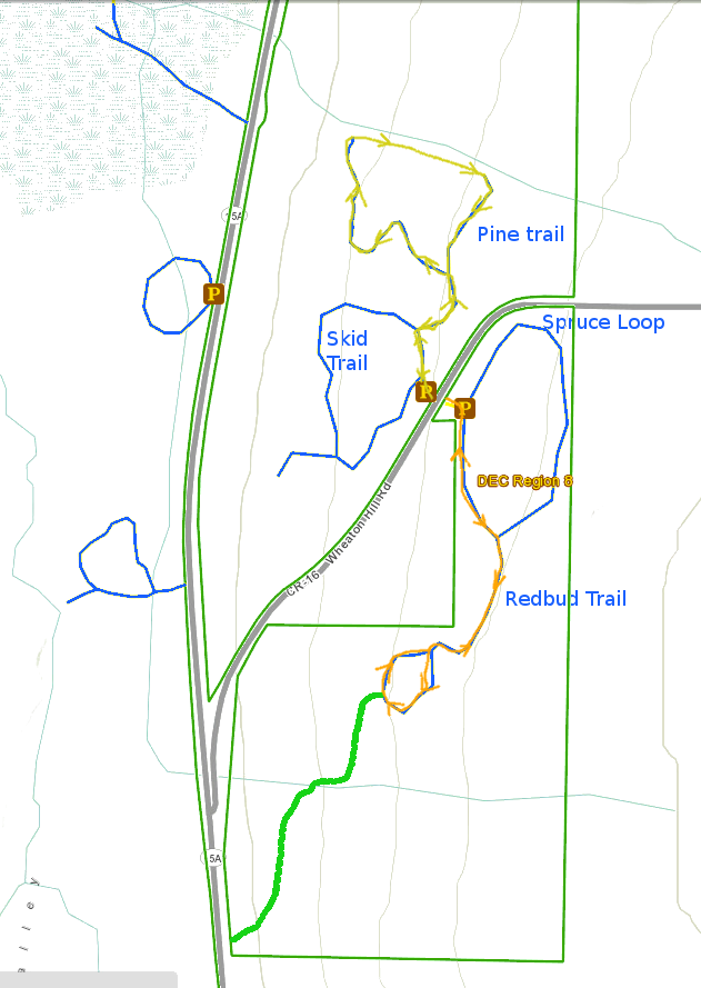
We will car pool from the Museum to Wheaton Hill. From the entrance, we will follow the Spruce Loop to the right and then the Redbud Trail. At the bottom of the Redbud loop, we will head out on an unmarked route across one gully to exit at the entrance to the Hamlet of Springwater. From there we will do a road walk along Main St through the hamlet back to the Museum. This will be a great time to share some history of the hamlet. Hikers with cars at the park will turn at Howe Av to return directly to the park.
Kayakers are also invited to join Springwater Trails at the Hemlock Lake South Boat launch at 4:00. Kayakers at the Community Day should leave the park or museum by 3:30 to provide time to unload equipment at the boat launch and be ready to push off at 4:00. Kayakers are required to wear a PFD (life jacket) and to stay with their group throughout the two hour paddle.
Hikers and Kayakers are urged to enjoy the Community Day and partake of the Chicken BBQ.Therefore, this Sunday only, we will not have our traditional social following our hike and kayak.
Looking for brochure.or mailing list so I can receive it in the mail.
Nothing opens up for mailing list.
There’s all kinds of very bizarre ads and post for viagra and other drugs above on calender page.
Please let me know if there’s a brochure available