
Hikes led by Springwater Trails are generally held on Sunday afternoons and appear in this calendar in green.
| Sun | Mon | Tue | Wed | Thu | Fri | Sat |
|---|---|---|---|---|---|---|
| Lehigh Valley Trail Hike or Bike in Rush, NY 2:00 pm Lehigh Valley Trail Hike or Bike in Rush, NY @ Stevens-Connor Lehigh Valley Lodge Apr 6 @ 2:00 pm – 4:00 pm Come join us for a leisurely hike or bike along the Lehigh Valley Trail on Sunday April 6th! With its flat even surface, the trail is a hidden gem for walking, hiking, jogging, biking. It is a vital link in … Continue reading | ||||||
| Ontario County Park at Gannett Hill Hike-Naples 2:00 pm Ontario County Park at Gannett Hill Hike-Naples @ Lookout Parking area Apr 13 @ 2:00 pm – 4:00 pm  This is one of our group’s favorite hikes! Ontario County Park at Gannett Hill is one of the highest points in Ontario County and located in the scenic Bristol Hills. At an elevation of 2,256 feet above sea level, you’ll … Continue reading | ||||||
| No Hike-Easter Break 2:00 pm No Hike-Easter Break Apr 20 @ 2:00 pm – 4:00 pm No hike has been scheduled for this date due to the Easter Holiday. Enjoy the break, spend time with loved ones and eat chocolate bunnies. This will give you something to burn off next week  | ||||||
| Hike Rob’s Trail – Hemlock Lake side 2:00 pm Hike Rob’s Trail – Hemlock Lake side Apr 27 @ 2:00 pm – 4:00 pm Join us on Sunday April 27th to hike the west side of Rob’s Trail, the DEC/Nature Conservancy property in the northeast corner of Hemlock Lake! Options are to hike out and back to the south along the trail from the … Continue reading |
The bald eagle has been chosen as the national symbol of our country. A pair, of these magnificent birds, has built a nest near the top of a tree south of Bath and, every year, since they built it, they have been returning to raise a brood, usually consisting of 2 chicks. In Mossy Bank Park, a hill, above this tree, offers a great vantage point to view the nest from above. Last year, we went there in early May and had a good look at the fuzzy chicks in the nest. This year, the parents have returned to the nest and, 2 chicks have successfully hatched. This time, we’re going back, later in the month, the chicks will be more mature and, if we’re lucky, we may see them walking around the nest.
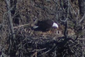
The Mossy Bank Park eagle feeding her chicks
May 2, 2015
– by Brenda Todd
Once again, Dr. Randy Wiedner, has offered to be our guide for this day. We will meet at 2 PM, at the nature center. Then, Randy will lead us to the eagle viewing ledge. Although he’ll set up a spotting scope for us, if you have binoculars, you’ll want to bring them for this one. After our view of the eagles, Randy will lead a hike through the trails of the park. For those preferring a slower pace, I will take you on some of the trails along the ridge and point out some of the features we encounter.
After our hikes, I have reserved one of the park’s pavilions, for a pot luck picnic. Randy, and his wife, Cathy, will join us as our guests. The rest of us need to bring a dish to pass, and beverage, or make a donation. After you’re done feeding your face, don’t run away. Make your way to the nature center, where Randy will show us his great bald eagle powerpoint. Besides seeing the history of this pair at this tree, you’ll see how our great national symbol was threatened with extinction in the mid 20th Century and the comeback that it made, due to the efforts of the late Rachel Carson, and other such heroes. You don’t want to miss this one. And, because it’s late May, it will still be light when you make your way home.
Go south on I-390 and east on I-86. Take exit 38 and go left at the end of the exit ramp. Go under 86 and turn right at the first traffic light, onto W. Morris St. Go past Tops, stay right at the fork, go past the library and make a sharp right onto Cameron St. Pass 86 again, and the Cohocton River and continue 1.6 miles. Watch for small Mossy Bank Park signs and fork to the left onto Windfall Rd. Go .4 miles and turn left onto Mossy Bank Park Rd. Go 1.3 miles to gate, marked with a small sign. Continue straight ahead until you pass between 2 large boulders, into the park. Park in the parking lot and come to the nature center.
Come spend the weekend in Western Maryland. Enjoy the hike, bike and kayak opportunities in the area of Western Maryland, New Germany State Park, Savage River State Forest and surrounding trail.
Note that Cumberland is a 5 hour drive from Springwater.
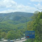 I believe this could be the first time Springwater Trails has attempted to organize a holiday weekend event in a new location, outside of New York State. There is an interesting area that is easy to travel to through Pennsylvania, just about 5 hours from Springwater, into Western Maryland. The terrain is similar to the Little Finger Lakes, complete with farmland, mountain-like hills, lush state forests, reservoir lakes, multitude of fishing creeks and rivers, hiking trails, old railroad beds (which are developed biking and hiking trails), outfitters, Amish and craft stores, and excellent restaurants and campgrounds. We’ve spent 3 months planning this event into this secret place and to date, we have 15 persons already registered from Springwater Trails and joined by some members of the Secret Hikers from Kentucky.
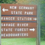 Our event will begin Friday afternoon after hikers settle into their respective campsites or motel rooms. We will gather at 4:00 at our campsite in New Germany State Park in Grantsville, Maryland.
 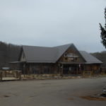 A short 2-3 mile hike in New Germany State Park will exercise our bodies after our long car ride, followed by dinner at the Cornucopia Restaurant on the Casselman River at 7:00. Reservations have already been secured for 12-15 persons.
On Saturday morning, we will gather at 9:00 at the Ranger Station of New Germany State Park, and will divide into two groups, one for kayaking, the other for hiking, and travel to the Savage River State Forest 10 minutes from our campsite.  We have a local outfitter that will deliver rented kayaks to the dry boat launch on the Savage River Reservoir for a 4 hour tour. (lunch will be provided, bring water shoes, and prepare to possibly get wet). Those experienced kayakers, with their own kayaks, will join us at the same boat launch to determine their own route with some suggested directions.(bring your own lunch).
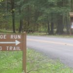
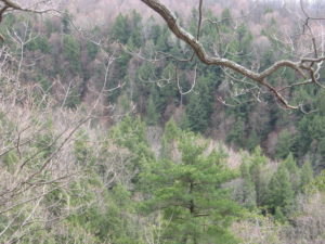
Hikers will travel close by to a spring wildflower trail called Monroe Run, 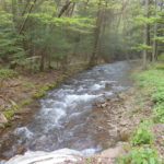 crossing the creek several times for a 5 mile, mostly flat hike in the State Forest. (bring water shoes for creek crossings and lunch).
Evening pot luck dinner and campfire will follow around 6:00 at our campsites in New Germany State Park.
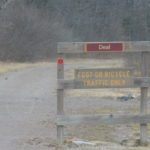 On Sunday we will bike the Great Allegheny Passage from Deal to Cumberland and hikers will walk from Deal to Frostburg or to their ability level. We will gather at 9:00 in Grantsville. Bikers will carpool to Cumberland where the outfitter will shuttle us and all bikes to Deal.
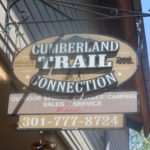 Regardless of whether you have your own bike or are renting from the outfitter, we will all ride the shuttle with the outfitter. The 24-mile ride from Deal to Cumberland will then take us back to our cars/bike racks.
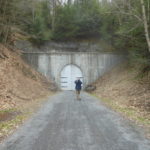
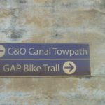 Bikers can decide if they want to continue on C& O Canal trail, have lunch in Cumberland, or return to their cars. Hikers will walk the same downhill flat path, passing through the Big Savage Mountain Tunnel about 2 miles south of Deal and a mile south of the Eastern Continental Divide.
 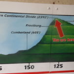 Some hikers may continue to hike 8 miles to Frostburg. Hikers will decide if they would like to lunch in Frostburg or join others in Cumberland at the railroad station and visitors center. Hikers may also choose to walk some on the C&O Canal trail. Dinner, which includes a cooking contest, will be provided by Canadice Kitchens. (bring your outdoor cooking stoves and cooking pot). Campfire and hot chocolate to follow.
On Monday, after checking out of our rooms or campsite before 11:00, we will have a short hike at 11:00 for those interested in staying longer. Others may want to check out the  historic Western Maryland train ride in Cumberland or other tourist areas located nearby.
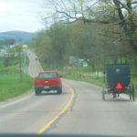
IMPORTANT NOTE: If you do not have reservations and would like to join us, we will try to accommodate late reservations if possible due to the holiday weekend. Contact Pam or Bill for details. Costs for outfitters: Kayak/tour $65.00 Bike rental (full day) $30. Bike shuttle as group of 8 about $27 each.
Directions from Springwater: Take 390 south to the Southern Tier Expressway (I-86, NY 17). Drive east towards Corning. Take US 15 which is also I-99 south into Pennsylvania. At William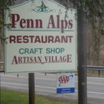 sport, take US 220 south. 220 is a bypass around Williamsport. The signs will say Lock Haven.
Take 220 south to I-80. Go west on I-80 (which is also 220). At the second exit, take 220 south. Signs will direct you to State College and Bellefonte. 220 also becomes I-99. Take 220 all the way through PA down into Maryland. The I-99 designation ends after Bedford.
In Maryland, you reach I-68. Go west, passing through downtown Cumberland, to Exit 22, the first of two Grantsville exits. After taking the ramp at Exit 22, turn right if you’re staying at the Casselman Inn. At the light on Alt 40, turn left and drive about 2 miles to the Casselman which will be on your right. If you’re staying at the Comfort Inn or camping at New Germa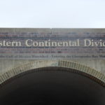 ny State Park, turn left from the Exit 22 ramp. The Comfort Inn is on your right on the other (south) side of I-68. For New Germany, continue on the road (Chestnut Ridge) until it dead-ends at a T intersection. Turn left and drive 2-3 miles – look for signs for New Germany State Park. The Park HQ and Visitors Center is on the right, the campground entrance is on the left – follow the signs.
Our Friday evening dinner is at the Cornucopia Cafe which is less than a mile from the Casselman going east on Alt 40. The restaurant is behind the Penn Alps restaurant.
Please contact Pam at pammasterson1 at yahoo.com before you come.
Other interesting resources are the GAP rail to trail path and the C&O Canal towpath.
The Game of Logging is the premier chainsaw training course and is highly recommended for anybody who uses a chainsaw. Level 1 is open to all, regardless of their experience, and will be offered on Saturday, 04 June, and Monday, 06 June. Level 2 is open to people who have taken level 1 and will be offered on Sunday, 05 June. You may register for both level 1 on Saturday and level 2 on Sunday. These classes are hosted by the Genesee County Department of Parks, Recreation and Forestry and the WFL chapter of NYFOA. The cost of the program is subsidized in part by the New York Center for Agricultural Medicine and Health (NYCAMH). Registration is required and is done through NYCAMH at (800) 343 7527 x2204. Further information is available at www.gameoflogging.com and www.nycamh.org.
Annually, one of two big shindigs that Victor Hiking Trails (VHT) sponsors, is National Trails Day (NTD) observed the first Saturday of June. In 2016 the date is June 4th. VHT is of course one of many hiking groups that plans some organized observance on NTD. Yep, that word “national” does in fact imply many groups across the USA observe or celebrate NTD in some manner. Now, before I describe more about NTD activities, you were wondering what the other big shindig that VHT has annually. Weren’t You? Answer: the second big shindig VHT does is the VHT “challenge hike” in late September.
NTD in Victor with VHT is usually three serial hikes, with a break in between each of the three hikes for rest and refreshment. The first hike is a morning hike and the last hike finishes in the afternoon.
You can read about National Trails Day from 2015 in the the VHT newsletter The Pathfinder Spring 2015 edition (volume 20, issue 1, page 6). And of course, you can check the VHT website for updated details about the NTD hike for June 4th, 2016. A direct hyperlink is here.
Hosted by the Finger Lakes Land Trust
 Join preserve steward and naturalist Eric Cosman for an exploration of the birds, plants, trees and other natural wonders at the Wesley Hill Preserve. Diverse stands of mature forest, a wide array of wildflowers, and sweeping views of the hills surrounding Honeoye Lake’s southern end make this site truly special. Don’t forget to dress for the weather and be sure to wear shoes you don’t mind getting wet.
 Directions: Meet at the Wesley Road entrance! From Honeoye, take Rt. 20A east to East Lake Road. Follow East Lake Rd. south for a short distance and then turn left on County Rd. 33. Continue a short distance and turn right on Pinewood Hill Rd. Follow Pinewood Hill, then Gulick Road south for approx. 2.5 miles. Turn right on Wesley Road and follow approx. 1 mile to the parking area on the left.
Look for other events sponsored by the Finger Lakes Land Trust on their website.
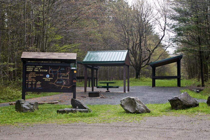
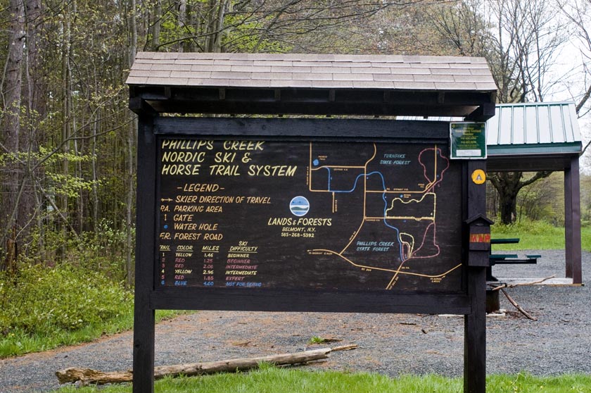 This week’s hike takes us in a new direction, Allegany County and Phillips Creek State Forest. Known as Allegany’ #1 Forest Area. It features 6 well market trails ranging from a 1.46 mile beginners trail to a 1.85 mile expert and a 2.96 mile intermediate section. It is composed of hardwoods and large stands of pines and spruce. During the 1930’s the Civilian Conservation Corps planted large stands of conifers. As of a couple of weeks ago, the lower trails were quite wet so proper footwear is advised in these areas. Maps will be provided.

Foot bridge over stream on trail 4 of the Phillips Creek Trail System for hikers and skiers with by-pass for horses.
We expect to have three groups based on the wishes of the group. All hikers will leave the parking lot and stay to the right onto Trail 3. Half way around the loop, we will get on Trail 4. At Stewart Rd, the climbers will take the loop Trail 5, then rejoin Trail 4 and follow the tourists and naturalists to trail 6 and back to the start point.
Here is a link for Philips Creek and information on Polly Wogg Holler
We have 2 options for the after hike social. Just down the road is Pollywogg Holler described as a Eco-Resort. Featuring pizza cooked in a wood fired oven Sunday’s from 1-6. Live entertainment for June 6 is “All Natural Speed Balls” with a $5 cover. Probably not for everyone. The other option would be the Country Kitchen in Hornell.
Directions to Phillips Creek State Forest.
 I have room for 3 or 4 riders if you want to meet at 22 East Lake Road, Loon Lake. To carpool from Loon Lake, we should leave about 12:45.
A self organized carpool from Wayland will meet at the parking lot behind the Fire Hall off of Rt 63 in Wayland just west of the Rt 15/Rt 21 intersection at 12:45 and be ready to leave promptly at 12:55 for Phillips Creek. Be sure to bring directions in case you need to drive.
From Springwater: Take Rt 15 S to Wayland and continue on Route 21 16.5 miles. When you reach Hornell turn right on County Route 66 go 0.28 miles and turn right on State Route 36 toward Arkport. Go 0.43 miles and merge onto I 86 W NY17 Southern Tier Expressway. Drive 5.4 miles and take Exit 33 Almond. Turn right on Karr Valley Road for 0.5 miles. Turn right onto Main Street NY 21 this takes you thru Almond. After 4.28 miles turn right on Hamilton Hill road for 0.09 miles and turn left onto Rt 244. Continue 1.28 miles and take a slight right and continue on State Route 244. Continue 6.05 miles to Phillips Creek parking lot across from Stuck Hill road.. Drive time is 52 minutes.
ADK Outdoor Expo 2016 is scheduled for Saturday June 11th, 2016, 10:00AM-4:00PM at Mendon Ponds Park. – – Outdoor activities and learning abound at this free event. – –
Here is a hyperlink to ADK Outdoor Expo. http://www.gvc-adk.org/expo
And here is a hyperlink to an article about the 2015 Outdoor Expo, included for reference of the myriad type activities.

Overlook (Honeoye Lake Harriet Hollister Spencer (1887-1962) was born in Rochester, NY. She was a Charter Member of the Rochester Garden Club and was known as a rose expert. She designed the Garden of Fragrance at the Rochester Museum and Science Center and contributed roses from her own garden. In 1963, her family donated, at her request, 679 acres of land to New York State for the Harriet Hollister Spencer State Recreation Area.
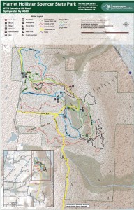 At 2000 feet, this park generally receives and keeps a good covering of snow each winter, and is one of four parks groomed for cross country skiing by the Rochester XC Ski Foundation.
Following the hike, an optional social will be at Sammy’s in Springwater.
The Naturalists will follow Bear Cub Run from the parking area to the snow shoe trail S6 just down the hill from the road. They will cross the overlook, cross Racoon Run, and then will make a short steep hike up to the loop at the end of the road. Then the Pines and Bypass trails will return to the parking area. Depending on the time, a hike to the north around the Big Oak trail may be possible.
The Tourists will similarly follow Bear Cub to the snow shoe trail, but will turn left on Racoon Run. Next is a left for a quick Fox Run loop, back to Racoon Run. Take the next left down to Lower Sidewinder, and follow that loop in a clockwise direction. At the information sign, we will stay to the left to follow a snowshoe trail across the snowmobile trail out toward Canadice Hill Rd and back. From their, heading north on Blue Spruce Run, Whiteface, and Cannonball, will bring us back to the road and the parking area.
The Climbers will follow Bear Cub Run to the road, and then will cross the road to follow the bypass and Chalet trails to the snowmobile trail. From there, we will follow the snowmobile trail south for about 2 miles, crossing into the town of Springwater, where we will turn west to reach the corner of Wetmore and Tibbels Road (which used to be named Springwater Canadice Town Line Road). Total length 3.3 miles, if we do not get lost.
Directions:
Check our standard directions to the HHS parking lot. Climbers coming from Springwater should meet at the corner of Wetmore and Tibbels Rd, to carpool to the parking lot. That way, we will have cars at the end of the hike.
From Springwater: (Climbers only): Take Route 15A north out of Springwater for one mile and turn right on Wheaton Hill Road. Continue to the top of the hill. At the T, turn left on Wetmore Rd. Stay on Wetmore, to the first road on the left (Tibbels Rd which used to be called Town Line Rd). You will see a welcome sign for Canadice. We will park on the right side, and car pool up to the parking lot.
Looking for brochure.or mailing list so I can receive it in the mail.
Nothing opens up for mailing list.
There’s all kinds of very bizarre ads and post for viagra and other drugs above on calender page.
Please let me know if there’s a brochure available