
Hikes led by Springwater Trails are generally held on Sunday afternoons and appear in this calendar in green.
| Sun | Mon | Tue | Wed | Thu | Fri | Sat |
|---|---|---|---|---|---|---|
| Lehigh Valley Trail Hike or Bike in Rush, NY 2:00 pm Lehigh Valley Trail Hike or Bike in Rush, NY @ Stevens-Connor Lehigh Valley Lodge Apr 6 @ 2:00 pm – 4:00 pm Come join us for a leisurely hike or bike along the Lehigh Valley Trail on Sunday April 6th! With its flat even surface, the trail is a hidden gem for walking, hiking, jogging, biking. It is a vital link in … Continue reading | ||||||
| Ontario County Park at Gannett Hill Hike-Naples 2:00 pm Ontario County Park at Gannett Hill Hike-Naples @ Lookout Parking area Apr 13 @ 2:00 pm – 4:00 pm  This is one of our group’s favorite hikes! Ontario County Park at Gannett Hill is one of the highest points in Ontario County and located in the scenic Bristol Hills. At an elevation of 2,256 feet above sea level, you’ll … Continue reading | ||||||
| No Hike-Easter Break 2:00 pm No Hike-Easter Break Apr 20 @ 2:00 pm – 4:00 pm No hike has been scheduled for this date due to the Easter Holiday. Enjoy the break, spend time with loved ones and eat chocolate bunnies. This will give you something to burn off next week  | ||||||
| Hike Rob’s Trail – Hemlock Lake side 2:00 pm Hike Rob’s Trail – Hemlock Lake side Apr 27 @ 2:00 pm – 4:00 pm Join us on Sunday April 27th to hike the west side of Rob’s Trail, the DEC/Nature Conservancy property in the northeast corner of Hemlock Lake! Options are to hike out and back to the south along the trail from the … Continue reading |
The Nature Conservancy of Central and Western New York has been planning to extend Rob’s trail down to Hemlock Lake for several years. Last summer several work days were held, building trail part way down from Rt 15A, and extended the lake side trail south from the north boat launch. A bridge is planned to cross a gorge and provide a wonderful and safe view of a waterfall on the way down to the lake. Currently there is a temporary route marked across the creek and the rest of the way to the lake.
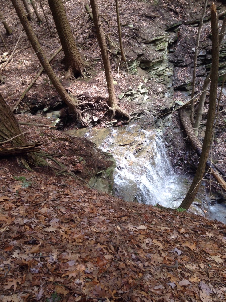 On Sunday, join us for a spring hike on this new trail and an optional social following at Peggy’s Rumpus Room in Honeoye. We will meet at the Rob’s Trail parking lot, and will split into three groups. The Climbers will hike down to the lake and connect to the new trail north to the North End (about 5 miles). The Tourists will hike down to the lake, and then will return back up the trail to the cars. This hike is about 3 miles, but makes up for the shorter distance with the steep climb back to the cars. Finally, the Naturalists will hike down the trail about half way to the lake where the bridge is planned. From there, they will return back to the cars, taking some time to explore a branch trail to the location of the proposed western parking area. This hike will be approximately 2.5 miles.
Following the hike, our optional social will be held at Peggy’s Rumpus Room at the Cornerstone Market. This is a small dinning area with soup, sandwiches and salads, plus bottled beer, and non-alcoholic beverages from the Cornerstone Market. To streamline the social, please RSVP to info@springwatertrails.org and to thecornerstonemarket@gmail.com. Please use the subject line “Springwater Trails Social April 3 at 4:30” with the number of people you are bringing and with your salad or sandwich order. You can find a menu at on their website. The restaurant is 10 miles from Rob’s Trail – go north on Rt 15A. Turn right on Rt 20A at Hemlock. The restaurant is at 8732 Main Street near the light at CR 36.
The Stid Hill Multiple Use Area is a 847 acre tract of land situated in the townships of Bristol and South Bristol in Ontario County. It is bounded by Route 64 on the west and Dugway Road on the north. Ganargua Creek, better known as Mud Creek, flows along Route 64. At one time, Stid Hill was productive sheep and cattle grazing land. Today the grazing has been eliminated. The mixture of steep hills, ravines, gullies, gorges, woods, and open areas create scenic vistas and also provide varied wildlife habitats.
The hike on Sunday 10th April 2016 will begin at the Dugway Road trail head. The initial quarter mile is a good path, but steep and uneven. This ends at a prominent “Stop” sign and a gate. This is a little misleading; a public trail continues past the Stop sign for a hundred yards or so and then swings to the right – follow the yellow Foot Trail buttons nailed to the trees and not the yellow paint dabs; the dabs lead away from public lands and will drop you on Stid Hill Road where it is still a dirt road.
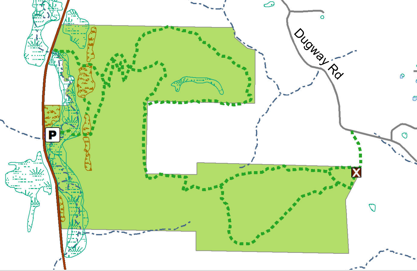 An alternative trail from the Stop sign goes to the right past a length of crash barrier across the path, and follows a broad trail up the hill (properly marked with paint dabs this time) deeper into the Stid Hill MUA. Both trails come together about a mile from the trail head.
Though the trails were well marked at one time, there hasn’t been much trail maintenance recently. The trail markers are difficult to follow and sometimes deceptive, and they disappear completely over the crown of the hill. The going will be very wet in places over the crown.
Tourists and Naturalists
For the tourists and Naturalists, there are loop trails starting at the Stop sign. The left and the right trails from the Stop sign are joined by linking trails through the woods. The paths are dry and in good shape here and marked with yellow or pink paint dabs.
Climbers
The climbers will hike all the way over Stid Hill and come down the steep escarpment to the more northerly Route 64 Stid Hill parking area. We’ll shuttle back to the Dugway Road trail head to collect the cars. The paint dabs start off yellow, but there a blue trail that parallels the yellow one and is easier to find. Here’s the route:
Once past the initial steep climb the trail is reasonably level until we come over the crown of the hill and start down the escarpment to Route 64. The trail markers run out pretty soon at the beginning of the walk, but the path is well trodden and easy to follow. It is however VERY WET! Wear good boots or get wet feet. It’s also very muddy in places. The section down the escarpment switchbacks a lot; it is steep, dry, and nicely wooded. The trail markers start up again as we start to come downhill again, but they get confusing and it’s easy to miss a sharp right turn to follow the borders of state land.
The Meeting Place
We will meet at the Dugway Road trail head at 1:45pm for a head count, and we’ll arrange to have some cars down at the Route 64 parking area for a ride back up the hill.
Getting There
Route 64 runs north-south, so there are only two direction of approach.
From the north, (Honeoye and Bloomfield) starting at Route 5 & 20 in Bloomfield, come down Route 64. 3.0 miles south of Rt 20A and 1.4 miles past Bristol Center (and CR 32), turn left on Dugway Road. If you come to a Stid Hill MUA parking area, you’ve come too far south – turn around and try again.
From the south, starting at Bristol Springs for 6.4 miles, come up Route 64 past both Stid Hill parking areas, then turn right on Dugway Road. If you come to Bristol Center you’ve come too far north.
From Springwater, Google Maps recommends heading north to 20A through Honeoye, then south on 64.
From Wayland, the recommendation is to take Rt 21 through Naples to the east end of Dugway Rd (4.5 miles north of the intersection with NY 64). The trail head is 1.2 miles west on Dugway, (Dugway is paved to the Bristol/Canandaigua town line).
Dugway Road is a good dirt road. The trail head is exactly 2.0 miles from the Route 64 junction. It’s easy to miss – it’s just a widening of the road after a sharp left turn. The trail head is on the right of the road and marked with a discreet sign a little too far from the road. Please park carefully. There isn’t much parking space to be had.
The Social
We’ll go to Lock Stock and Barrel on Route 64 just north of Bristol Mountain for the social after the hike. The climbers are likely to be about half an hour late so earlier arrivals should feel free to set up beers for them for when they finally get there.
Agenda
  Approve minutes – Katherine
    Please review the minutes prior to the meeting. Please look in the dropbox

  Treasurer’s report – Melissa

  Committee Reports
    Advertizing – Katherine
    Trail Maintenance – Gene
    Trail Building – Rick
    Bicentenial Committee – Wendy, Mark
    Hiking Group – Wendy
      Winter Hikes

  New Business

  Next Meeting
 Doors open at 7:30
Live Music by Howie Lester’s Party Band.
Caller: Jim Kimball
Donations accepted to benefit Save the Community Center
Come alone, with your favorite partner or with all your neighbors!
Founder’s Day is Sunday, April 17 and will be celebrated with several activities at the Springwater Fire Hall (8145 South Main Street), including an interdenominational worship service from 10:00 to 11:30 a.m. followed by a chicken barbecue, and, at 1:00 p.m., a special dedication ceremony attended by Senator Catharine Young and several other county and state officials.
See the original declaration here. Springwater is created by Law
Contact: Judy Tripp-Neu at 669-2683.
![]() It’s going to be an exciting Sunday, celebrating the Springwater Bicentennial. Events start at 10:00AM at the Springwater Fire Hall with a communal church service. Following the Service, a chicken BBQ with $9.00 chicken dinners with all the trimmings. At 1:00PM, the Waylandaires will perform, there will be birthday cake for Springwater, and expect some speeches from local and state representatives in town to celebrate with Springwater.
It’s going to be an exciting Sunday, celebrating the Springwater Bicentennial. Events start at 10:00AM at the Springwater Fire Hall with a communal church service. Following the Service, a chicken BBQ with $9.00 chicken dinners with all the trimmings. At 1:00PM, the Waylandaires will perform, there will be birthday cake for Springwater, and expect some speeches from local and state representatives in town to celebrate with Springwater.
Following the cake, Springwater Trails will meet in the Fire Hall parking lot for a walk through the hamlet of Springwater. All friends of Springwater looking to celebrate the town with a two hour walk around the hamlet are invited to join us.
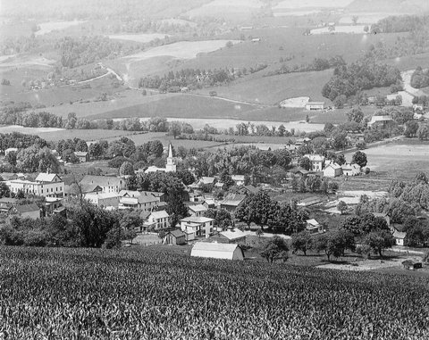
The Hamlet of Springwater from the north east hill. The intersection of Kellogg Rd and Depot Rd in the distance will be one of our hike goals. Photo courtesy of Joyce O’Neil via hemlockandcanadicelakes.com
We will visit Canute Park and the Springwater Creek, which drains the west hill of Springwater valley, and we will cross Limekiln Creek, which drains the east hill. A swing across Kellogg Rd marks the north edge of the hamlet. The hike will take two hours and we will return to the cars.
Bring old pictures of the hamlet, if you would like to share them as we hike. We are expecting a clear day with temperatures in the 60’s. Following the hike, we will gather at Canute Park for a pot luck social. Bring a dish to pass, and something to drink.
Volunteers are needed to assist in picking up roadside litter along a stretch of highway in the Town of Springwater that Springwater Trails is in the process of adopting. We will meet at the Fire Hall parking lot at 9AM for a mandatory safety briefing presented by NYS DOT. They will provide the required hard hats and safety vests. You will want to bring gloves. NYS DOT will also provide the collection bags and pick up. The plan is to work from 9AM-12PM, lunch at Sammy’s, and (if needed) work from 1PM-4PM. Ask your friends to join us. So NYS DOT can be given an approximate number of participants, please let Wendy know if you plan on helping out – wsteven@frontiernet.net .

Saturday, April 23, 2016 at 10:00AM , this will be a short hike, with lots of history about the CCC Camp at Big Bend in Letchworth State Park. The announcement, states: 3 hour, moderate walking 1/2mile, bring a lunch. At 10:00AM, the “meet locale” is at Parade Grounds parking lot, and then there will be a carpool to the event site (the Big Bend CCC Camp).
This event is offered thru the Letchworth State Park hike and activity series. A very active series that holds numerous hikes and other activities year round, mostly in Letchworth State Park and on the Genesee Valley Greenway State Park (aka GVG -or- GVGSP). These events are published in The Genesee Naturalist published quarterly.
This event is led by Historian and author Tom Cook, author of a book about the Letchworth Park CCC Camps, and author of other books as well.
Also of note, Tom Cook will be presenting the Avon Preservation and Historical Society (APHS) program about the Genesee Valley Canal (GVC) during which he will particularly highlight the challenging area of canal construction in and surrounding present day Letchworth State Park. This APHS program is scheduled at 2:00PM on Sunday April 24th, 2016 at the Avon Opera Block second floor meeting room (handicap accessible) located at 23 Genesee St in the Village of Avon (off the west/southwest side of the traffic circle in the Village of Avon that Routes 5&20 navigate through.
Following this presentation, Springwater Trails will be holding a hike (hike meet at ~3:15PM or so) on the former GVC corridor (now the Genesee Valley Greenway State Park aka GVGSP -or- GVG). This Springwater Trails hike will be on the GVG (spanning miles 12-17 of the GVG) in town of Caledonia which is just across the Genesee River from Avon. Various length hike groups are planned for on this hike, the shortest of which is suitable for mobility limited hikers (inclusive of wheelchair hikers).
Please Note!! This is a schedule change from the original Springwater Trails – Spring 2016 Hike Schedule Brochure for Sunday, April 24, 2016. (The original hike locale was Keuka Lake Outlet Trail which will be rescheduled for a later date.)
- Please note: This is a rather long Hike Announcement – so you’ll want to “click on” (mouse left-click) the title so you can view the hike announcement in full page width for easier reading and overview. A “quick reference” of event timing is included for synopsis convenience.
QUICK REFERENCE for this Sunday, April 24th, 2016 hike combo event:
2:00PM in Avon @ 23 Genesee St (Avon Opera Block), 2nd floor meeting room – history presentation on the GVC. ~GPS coordinates: 42.911676 , -77.746490 (basicallysituate alongside the Village of Avon traffic circle, Rts 5&20 navigate as part of the circle, and Genesee St runs off the circle)
~3:15PM @ “Hike Meet Locale“ (but not the hike start point) for this GVG hike is at Berry’s Park on Rts 5&20 (West Main St, Avon) situate along the east side of Genesee River . ~GPS coordinates: 42.917666, -77.756808 (Berry’s Park is situate on Rts 5&20 directly opposite jct with Farmers Rd, also described as situate ~6/10ths of a mile west of the Village of Avon traffic circle)
~5:30PM “Hike End Point“ @ approx address of 101 River Rd (Caledonia) in small access parking lot for LVT access trail ~GPS coordinates: 42.983157 , -77.743363 (reference point of this parking lot, it is immediately north of the large driveway for Centerpoint Transfer Station Inc., 119 River Rd).
~5:30 – 5:45PM or so, is gathering time for an “After-hike Social” at Avon Driving Park at the end of Spring St in Avon. Bring a dish to pass and your own beverage or make a suggested $5 contribution to the Social Fund. Avon Driving Park is a tobacco and alcohol free zone.
Click here for driving direction to all locations.
Value Added History Presentation at 2:00PM, followed by a hike
The Springwater Trails hike for Sunday, April 24th, 2016 is scheduled on the Genesee Valley Greenway (GVG) in the area just west of Avon NY (northern Livingston County). This is a “value added” hike combo event. At 2:00PM organized by the Avon Preservation and Historical Society (APHS) there will be an ~ hour long program presented by Historian and history author Tom S. Cook, … program presentation topic is history of the Genesee Valley Canal, quite apropos for a paired GVG hike. This free program presentation will take place in the second floor meeting room of the Avon Opera Block building, 23 Genesee St., located in the Village of Avon, Livingston County. (For point of reference: The Avon Opera Block situate on the west side of Genesee St, is just off the west/southwest edge of the traffic circle, and said traffic circle is variably referred to as Circle Park aka Village Green / Village Green Park in the Village of Avon. Routes 5&20 flow through the traffic circle.) A webpage on the APHS website will inform you further about this presentation http://www.avonpreservation.org/events/ -or- http://www.avonpreservation.org/events/2016/4/24/the-genesee-valley-canal
~GPS coordinates for 23 Genesee St (Avon Opera Block) 42.911676 , -77.746490 *Please Note: The Avon Opera Block 2nd floor meeting room is a handicapped accessible facility.
Immediately following the presentation light refreshments are served by APHS folks, so hikers attending the presentation may quickly avail themselves of such and perhaps some brief conversation before making it to the nearby hike locale. The APHS program and refreshments are free (as is the Springwater Trails scheduled hike), donations to the APHS are welcome. Some APHS published materials and other Livingston County area history publications may be available for sale before and after the presentation, this includes some books authored by Tom S. Cook.
Please note: the APHS Programs are a popular series, and so you may have to hunt a bit for a parking space. Especially if you arrive just before the program starts, you may not be able to park right in front of the Avon Opera Block.
The Hike starts at ~ 3:15pm (optimistically stated) or so
This week’s Springwater Trails hike will be a Genesee Valley Greenway (GVG) hike, variably utilizing miles 12 thru 17, all of which are in the Town of Caledonia, NY. Caledonia is the town immediately to the west of the Town of Avon. (By-the-way, the Village of Avon is wholly located within the Town of Avon.) Towns of Avon & Caledonia share common border of the Genesee River, and both these Livingston County towns situate in the northern section of the county also border with Monroe County to the north.
Hike start time is approximately between 3:15 & 3:30pm, allowing to be sure all those who attended the GVC history presentation have made it to the “hike meet locale”. Hike Leaders will make the call as to when all have arrived, based on faces they saw at the APHS sponsored GVC history presentation. Hike duration will be approximately 2 hours.
Hike distances will vary for the four groups planned for: Climbers ~5 miles, Tourists ~3+ miles, Naturalists and Flatlanders ~less than two miles. Hike Terrain is nearly all flat, as the majority of the hike routings traverse a former canal and railroad route, albeit there is a slope downward from River Rd access parking lot of the LVT access trail to the GVG & LVT trails alongside the river (and slope upward when traversing back to the parking lot). Naturalists and Flatlanders routings are substantially seasoned stone-dust surface, and so are by design accessible to mobility limited hikers (inclusive of wheelchair hikers). Much of the GVG surface itself is design of a grassy laneway (a grassy median separating two tire trackings) and could further be described as substantially grass variably mixed with segments of stone dust, cinder, gravel, crushed stone, and earth.
— SOME ADDITIONAL GVG INFO AND HIKE INFO —
For those unaware, the GVG, which a few years ago became a linear NYS park (aptly named “Genesee Valley Greenway State Park” aka GVGSP, but still referred to as GVG in short), approximately follows the routing of the former Genesee Valley Canal (~1840-1878) and the GVCRR and successor railroads ~1882-1970s).
The GVG multiple-use trail has it’s existence greatly owed to the Friends of the Genesee Valley Greenway (FOGVG), and the FOGVG continues efforts on the GVG to this day. Additionally, NYSDEC and many other supporters helped make the trail what it is today with involvement well before it became a NYS Park.
Springwater Trails, over time, has held a number of different hikes on the GVG and one on Nov 1st 2015 was in concert with the FOGVG group’s planned hike (in the Cuylerville area) and the FOGVG annual meeting.
History of the former GVC & GVCRR corridor will not only come to light at Tom Cook’s presentation about the GVC, but also as you hike the GVG.
Of note: There is a Wegman’s “Passport to Family Wellness” booklet specifically for the GVGSP and which covers numerous hikes on the GVGSP; and the “rubbing post” of Wegman’s hike #4 is located at the jct of the GVGSP & the Lehigh Valley Trail. Yes, hikers in all hiking groups today will have access to rubbing post #4. Please note, the section of the GVG we’ll be hiking extends southward from rubbing pole #4 ( whereas Wegman’s hike #4 utilizes the GVG trail northward from rubbing pole #4). So bring your GVGSP Wegman’s Passport to Family Wellness booklet to make a rubbing at post #4 if you’d like (you’ll also need a pencil or crayon to make the rubbing). Some booklets may be available to hand out to hikers who do not already have a booklet, for those interested in the Wegman’s Passport “rubbing” collection and redemption program. Rubbing Post #4 ~ coordinates: 42.984585 , -77.732762 for all you GPS folks.
Hike Meet Locale – Berry’s Park in Avon, NY ( ~ GPS coordinates: 42.917666, -77.756808 )
Please note this is NOT the hike trailhead (aka hike start point). “Hike Meet Locale” , Berry’s Park, is ~ 6/10ths of a mile west of the Avon traffic circle on Routes 5&20 aka West Main St. (Berry’s Park can also be described as directly opposite Farmers Rd which runs north of Rts 5&20.) Hike meet locale is in the parking lot on U.S. Rt 20/NYS Rt 5 situate at the southeast corner jct with the Genesee River ~GPS coordinates for Berry’s Park parking lot: 42.917666, -77.756808 . This meet locale is at a NYSDEC fishing access site parking lot variably referred to as Berry Park or Berry’s Park (a pocket park), and you’ll find a NYS blue and gold historic sign about “Berry’s Tavern” alongside the parking lot. (By-the-way, not only is this a fishing access site, but it is also apropos as a kayak access site, so kayakers and hikers too, take note and impetus.) In this parking lot, chosen as meet locale due to it’s ample size, we will form hiking groups and determine what cars will go where enabling ease of utilizing two separate hike start points (one for Climbers, and another for Tourists/Naturalists/Flatlanders).
Hike Logistics for vehicles and various hiking groups
Routing/Logistics: There are two separate hike start points for today’s GVG hike; one start point for Climbers, and a separate start point for Tourists/ Naturalists/ Flatlanders. Basically, Tourists/ Naturalists/ Flatlanders will be driving and drop Climbers at one start point and then will drive further to their own start point.
Climbers will hike ~ 5 miles, a linear one-way principally south-to-north hike via: ~4 or so miles northward on the GVG from start point (trail head) at NYS Rt 5, to the jct of the LVT & LVT Access Trail (in railroad days dubbed “Wadsworth Junction”) and then head westward on the LVT access trail to the LVT access trail parking lot situate on River Rd.
Before heading west to the parking lot, please note while at the GVG/LVT trail jct, Climbers will be able to view the “wow factor” of the remains of the LVRR bridge which crosses the Genesee River. Of note, the lower remains of this bridge are now used as the designated trail crossing the river – a connection from the start of the LVT (“mile 0” of the Monroe County linear park named LVT) as the LVT heads eastward, connecting to the LVT access trail that heads westward to the parking lot on River Rd. At “Wadsworth Junction” Climbers can explore the area as time may allow, before the remaining short trek to the parking lot where Tourists/Naturalists/Flatlanders have parked vehicles.
– – – Climbers – Logistics note, there is no parking area on NYS Rt 5 for the GVG, so Climbers will be dropped off at the trailhead by Tourists/Naturalists/Flatlanders. Please note: at end of the hike Climbers will be shuttling back to Berry’s Park parking lot in Avon (which was the “hike meet locale”) with the Tourists/Naturalists/Flatlanders. – – –
Climbers more detailed hike info – Along the approx. 4 miles on the GVG (which here is principally north-south traversing), Climbers will pass the Erie-Attica Trail (EAT) jct, and further north pass some non-designated trail junctions (farm roads & driveways), and then ~ 1/3 mile south of milepost 13 will pass bridge abutments for a former east-west traversing railroad (the “Peanut Line of NYCRR). When essentially reaching the jct with the Lehigh Valley Trail (LVT) that heads eastward from the Genesee River and the LVT access trail (also referred to as the LVT extension) that heads westward from the river & GVG and leads to River Rd LVT access trail parking lot, Climbers ultimately will head westward to that parking lot.
Tourists, Naturalists, and Flatlanders from the Berry’s Park “hike meet locale” will drive westward on Rts 5&20 (crossing the Genesee River and soon passing the bifurcation of US Rt 20 which is to the left and slightly to the south, while Rt 5 is basically straight with a sweeping curve slightly to the north). You’ll drive on NYS Rt 5 approx 1 mile to the GVG trail crossing point where there will be a quick drop-off of Climbers at the GVG trailhead at NYS Rt 5.
(By-the-way, don’t be confused by any construction detour signs that may be present for US Rt 20 along the way, you wanna take NYS Rt 5.)
There is NOT a parking lot at the GVG trailhead on NYS Rt 5, where Climbers will be dropped-off, there is only the roadway shoulder which is NOT overly generous and is bordered by guardrail on the north side of NYS Rt 5. For safety of dropping Climbers, if necessary and thought prudent the road shoulder on the south side of the roadway is wider for potential easier use AND on the south side of NYS Rt 5 just past the trailhead there is the very wide driveway apron entrance to Valley Sand and Gravel which could provide a space for being totally off the roadway when dropping Climbers. (There are “no parking” signs posted at Valley Sand & Gravel entrance but, being a Sunday and likely no trucking activity, a mere pause in the apron area allowing to be totally off NYS Rt 5 in order to the drop-off the Climbers should not be a problem.)
Tourists/Naturalists/Flatlanders then will continue to drive on NYS Rt 5 to the next right-hand turn (County Rd 84 aka River Rd aka West River Rd) and will drive approximately 4 miles northbound on River Rd to the Lehigh Valley Trail access trail parking lot on the east side of River Rd.
At this parking lot is the trailhead for these three groups, which all will hike eastward from the parking lot to the junction with the GVG (“Wadsworth Junction” in nomenclature of the Lehigh Valley Railroad aka LVRR from days gone by) and will explore this junction area, the 1891 LVRR bridge and remaining bridge abutments area (on both sides of the river), and will hike variably distant mileages on the GVG southward before turning around and retracing their route to the parking lot. (Climbers also will finish at this parking lot, and will get rides from Tourists/Naturalists/Flatlanders back to Berry’s Park parking lot in Avon.)
More detailed info to find the start point parking lot (trailhead) for Tourists/ Naturalists/ Flatlanders: After dropping the Climbers, and continuing following NYS Rt 5 westward for a short distance to River Rd (aka West River Rd, aka County Rd # 84), turning right you’ll drive northward on River Rd approximately 4 miles to the small LVT access trail parking lot ~GPS coordinates: 42.983157 , -77.743363. You will find this parking lot on the east side of River Rd immediately past the driveway for Centerpoint Transfer Station Inc {119 River Rd}, and directly opposite the tall rectangular sign on the west side of the road that demarcates “Livingston Business Park” which has an address of 100 River Rd (CP Ward Crane / Construction Co and KBH Construction as two principal occupants of the Livingston Business Park).
The LVT access trail parking lot can accommodate perhaps 6 vehicles or so, and is up a slight rise from River Rd, and can be described as tucked away from plain view if you do not know to look for it. The very short gravel entrance drive to this raised from the road parking lot can also be described as bounded by two guide wires from utility poles along the east side of River Rd. (Additional parking may be had at roadside, or perhaps at Livingston Business Park parking lot across the street. Of note, Centerpoint Transfer Station Inc at 119 River Rd, accessed via the very wide driveway next to the LVT access trail parking lot driveway does not operate trucking operations on Sundays.)
Tourists, Naturalists, and Flatlanders will hike eastward on the LVT access trail to reach the four-way intersect with the GVG and LVT at the Genesee River. These groups will have ample time to explore this jct area. There are Interpretive Signs in this area about the GVC, the GVCRR, & the LVRR (the LVRR with its once huge approach (trestle) to the LVRR bridge over the Genesee River), and more about lay of the land including railroad junctions. The interpretive signs provide a mini history lesson in and of themselves, and assimilate you to the “lay of the land” as it previously existed. [By-the-way, the jct interpretive area also has benches and picnic tables.] Of note, the LVT access trail affords views of the high abutments for the trestle that formed the approach to the former LVRR bridge over the Genesee River. There are also even more impressive approaches to the bridge lying on the east side of the Genesee River along the LVT linear park.
Of course, being that this is a GVG hike, Tourists, Naturalists, and Flatlanders will all hike some distance southward on the GVG after appreciating the numerous things to see at the jct area.
Tourists in hiking southward on the GVG and gauging the two hour hike time will turn around and retrace their steps for an approx two hour hike. Naturalists will do the same, but cover less mileage at a slower pace, as will the Flatlanders to their ability.
All groups, will ultimately close-out the hike by heading westward on the LVT access trail to the parking lot on River Rd where Tourists/Naturalists/Flatlanders parked. Climbers will get rides back to their cars that were left at the NYSDEC fishing access area parking lot (aka Berry’s Park) and all will then have opportunity to join in an after-hike social to be held either at Tom Wahl’s Restaurant in Avon -or- at Avon Driving Park situate at the end of Spring St in Avon. A determination for social locale will be made shortly before hike day.
After-hike Social
After-hike Social at Avon Driving Park (known as Avon Downs to the locals) at the end of Spring St in Avon ~ GPS coordinates 42.906791, -77.766153 This park contains a horse racing track of former glory days and is located at the end of Spring St in Avon. Spring St can be accessed directly from NYS Rt 39 aka Wadsworth Ave (as well as from Genesee St), or via River St off Rt 5&20 to Spring St. Routing directly from our 4/24/2016 hike – the most direct way is Rts 5&20 to River St to Spring St. Follow the signs for Avon Driving Park, and go slow on Spring St as there as definite curves and slopes.
Avon Driving Park social will be pot-luck format: please bring your own beverage (non-alcoholic as this park is an alcohol & tobacco free zone), and dish to pass (or make a suggested $5 donation to the social fund) . Park facilities: two (closely situate) north and south picnic pavilions have picnic tables and benches, charcoal grills, electrical / area lighting, water spigot located near the picnic pavilions, restroom building with running water, playing fields, more, and of course the quintessential elliptical shaped horse race track. – – – (Updated Note: Seasonal opening of the restroom building with running water occurred on Friday 4/22/2016. Sincere Thanks to the Avon Parks Dept folks for this superb timing! Of note: There is a porta-potti in the park for use when the restroom building is closed.)
Miscellanous:
**For disambiguation purposes (minutia), there are several segments of the former Lehigh Valley Railroad right-of-way that have been converted as rail-to-trail. The LVT routing through towns of Rush & Mendon as an east-west oriented Monroe County linear park (that we briefly border/touch in today’s hike) is but one of those, and it is coupled by the former LVRR bridge over the Genesee River with the LVT access trail aka LVT extension (which we all hike today) that is in the far northern reaches of the town of Caledonia and which runs from the Genesse River westward to the LVT access Trail parking lot situate at River Rd. Two others nearby: 1) there is a basically n-s oriented LVT that heads north from the former LVRR “Rochester Jct” in the town of Mendon and progresses northward to the Town of Henrietta , 2) in the Town of Victor there is a LVT as well as a contiguous Lehigh Crossing Park.
One advantage of a hike such as this one with timing in later April before deciduous leaves come on to trees and bushes in May is that hikers can see more beyond the sides of the trail than would be the case with foliage present. And mosquitoes are not yet “is season” that may populate areas of standing water such as sections of former canal trough, artificially created low spots and/or ponds created by construction such as creating a right-of-way for railroad tracks elevated from surrounding topography including removing earth immediately adjacent the right-of-way to build up the right-of-way, quarrying operations, and naturally occurring low spots of topography.
Darn, You say. You can not make this hike?, but want a group hike to explore the “Wadsworth Junction” area including the 1891 built LVRR bridge remains over the Genesee River? Don’t fret, a future S/T hike will be held (date yet unknown) on the Lehigh Valley Trail (LVT) utilizing this area of trail, and other GVG hikes including one led by NYS Park staff will be at hand.
Some other opportunities on the GVG for a hike. There is a 2 year series of hikes 2015 & 2016 on the GVG linear state park (GVGSP), totaling 14 hikes (7 in 2015 & 7 in 2016). Each hike is held on the 2nd Saturday of each month April-October. You can read more about these hikes at www.fogvg.org -or- www.nyparks.org events. Both the May & June 2016 GVG hike series scheduled hikes are in the proximate contiguous area of the GVG as the Sunday 4/24/2016 Springwater Trails hike.
A Hike Planner’s trials & tribulations note: In April 2016, a small section of US Rt 20 in the Town of Caledonia is closed for construction. US Rt 20 just west of the Rts 5&20 bifurcation and east of the GVG US Rt 20 trailhead and parking lot (and also east of River Rd aka West River Rd) is closed and a detour exists for this segment of US Rt 20, due to construction of two culverts passing under the roadway. Thus our hike on 4/24/2016 has chosen not to use the GVG US Rt 20 trailhead and parking lot. This detoured section of US Rt 20 is predicted to be reopened sometime ~ 4/22-25/2016 or so. Thus it may or may not be open on 4/24/2016 hike day. – – – However, it is expected to be open for easy access traverse of US Rt 20 in order to get to the Saturday June 11th 2016 hike that will be on the section of the GVG directly south of the US Rt 20 trailhead, as hosted and led by GVGSP staff in the GVGSP hike series April-October 2016 (6/11 hike meet is a 10:00AM at Fowlerville Rd GVG trailhead, but check with GVGSP for any possible updates before you go).
One more chance to learn more history from Tom Cook; Tom is leading an event hike in Letchworth State Park on 4/23/2016 Saturday (the day just before this Springwater Trails hike). The topic is THE CCC CAMP AT BIG BEND IN LETCHWORTH STATE PARK. Here is a hyperlink to the event info.
A very brief History Primer of the GVC, and more info relevant to this 4/24/2016 hike and this transportation corridor evolution
The GVC ran from the Erie Canal in downtown Rochester (in the area of present day Canal Street adjacent Broad Street & Allen Street, kinda behind present day Nick Tahou’s Restaurant) to points southward, greatly paralleling the Genesee River, and the southern terminus of the GVC was designed to connect to the Allegany River, and thus was anticipated to give connection to the Ohio River and ultimately to allow for access to the Mississippi River. But, … with the advent and popularization of railroads and competition therefrom, the Genesee Valley Canal came to be non-profitable, that grand plan of fully navigable commerce routes to larger rivers to the west never having come to fruition. Problems with maintenance, expenses and profitability, and more were owing to a number of factors, not just railroad competition. There are parallels with numerous other canal systems that were ultimately closed, in part bowing to railroad competition. Canal building mania, on the shirt-tails of the success of the Erie Canal, proved to be not the best investment in those who undertook involvement in such.
More about this GVG corridor, from days gone by. After the GVC was permanently closed in 1878, the Genesee Valley Canal Railroad became the first railroad to occupy the former GVC corridor. The GVCRR itself would undergo two additional successor railroad ownerships before the railroad corridor would eventually (~1900) come to be the Rochester Branch of the Pennsylvania Railroad. In the 1960s the Pennsylvania RR & the NYCRR merged to become the Penn Central RR. The 1960s saw closure of much of the north-south rail corridor that once was the GVC with some of this railroad corridor continuing open into the 1970s.
Of course, Tom S. Cook will be presenting much more about the GVC corridor at the 2PM APHS program!!!
Also of note, while today’s hike is a GVC history hike and we’ll be traversing the corridor of the GVC/GVCRR & successors and a small portion of the LVRR corridor (an east-west traversing corridor), this hike also weaves in two other railroad corridors (east-west traversing) of bygone railroads.
> 1) The former Attica Branch of Erie Railroad, part of this corridor is now the Erie-Attica Trail (EAT), intersects the GVG ~ 1/4 mile north of NYS Rt 5. (Climbers hiking group will see the GVG/EAT trail junction on the hike.) The EAT intersects the GVG from the east, and the corridor to the west while not a trail today is projected to someday have trail extend to River Rd (and perhaps beyond). The former Erie RR Attica Branch corridor intersects with River Rd ~ 1/10th of a mile north of NYS Rt 5, look for the very first “tree row” extending from both sides of River Rd as you are driving northward and you’ll see it.
> 2) Often referred to as the “Peanut Line” but officially designated as Batavia Branch of the NYCRR, this east-west traversing railroad corridor originally chartered as the Canandaigua and Niagara Falls RR in 1851 opened its first section from Canandaigua to Batavia in 1853, with more sections to open quickly following. But come 1858 this bankrupt RR was purchased by the NYCRR and reorganized as the Niagara Bridge and Canandaigua RR, and in 1890 the NYCRR reorganized this entity into itself. Owing to its relatively small size in comparison to the whole of the NYCRR miles of track, it got a quick vernacular designation as the “Peanut Line” attributed to a comment made by a NYCRR administrator- something to the effect that it was a small peanut of a line. The Peanut Line former RR corridor intersects with the GVG about 1/3 mile south of the GVG/LVT jct. (So, All hiking groups will have opportunity to see this jct where the Peanut Line passed over the current GVG corridor if they wish to). The intersect is evidenced by remaining bridge abutments, and also by high voltage power-lines and poles crossing over the GVG. The Power lines and poles demarcating the corridor can also be seen at the south edge of Dugan Creek Logging & Lumber property on River Rd as you drive by. Additionally, hikers on the GVG may be able to see some remaining bridge abutments of the former Peanut Line over Dugan Creek (these are just east of the GVG). And a bit further east (but not visible from the GVG) would be the remaining bridge abutments demarcating the crossing locale of the former Peanut Line over the Genesee River to “Golah” on the east side of the river.
(Of note, “Golah”, at the western end of Golah Rd is situate along the south side of Honeoye Creek just before the confluence with the Genesee River and is a possible kayaking access point to both Honeoye Creek and the Genesee River.) Golah is the point where the Peanut Line of the NYCRR and the Rochester Branch of the Erie Railroad (today the Livonia Avon & Lakeville RR – aka LAL RR – operates the former Erie trackage {a n-s traverse} in this area) had junction. Golah Rd runs westward off East River Rd to a dead end and is located in the Town of Rush.
A few years back, there was impetus to have the Peanut Line as a rail-to-trail right into the heart of Honeoye Falls, and various permissions were granted, but some private property was involved for which no permission could be obtained (so it never happened). Of note, there is a Peanut Line rail-to-trail in Canandaigua area (Ontario County) and another in Clarence area (Erie County).
If as you hike the GVG and/or drive River Road (and surrounds) you discern possibilities (past, present, and future) of quarrying for sand and gravel throughout this area of Caledonia well, … you’d be correct! In fact, akin to this, very near the jct of the LVT access trail and the GVG, you’ll find a boulder with inscription that Joe Spezio of Elam Sand and Gravel in 1998 donated a number of acres of land along the Genesee River for use of the GVG.
??? – Still thirsting for more GVC and RR history, relative to this transportation corridor now dubbed the GVG? There are many interpretative signs in various locations along the GVG, including some at Canawaugus Park (which is located along the GVG ~ milepost 10). Canawaugus Park spans Oatka Creek at the se corner of the Village of Scottsville on NYS Rt 251. There is parking at Canawaugus Park, for park, trail, and fishing access. Oakta Creek (which flows eastward toward the nearby Genesee River) was one of many water sources for the Genesee Valley Canal (which opened in 1840) and Oakta Creek was also a water source for the short-routed and short-lived “Scottsville and Genesee River Canal” (1838-1840).
Of course your local library system has many books on the topic of NYS Canals and NYS Railroads, as well as many more local history topics, and HIKING too!. There are also internet resources on these topics.
A hike that Springwater Trails did on Sunday, 10/18/2015 in conjunction with another APHS program – this one on the 1876 Avon Opera Block has a hyperlink here.
Disclaimer: While attempts are made to present factual historical information, there is no guarantee of no slip-ups such as typographical or some manner of factual err in the information contained herein.
Looking for brochure.or mailing list so I can receive it in the mail.
Nothing opens up for mailing list.
There’s all kinds of very bizarre ads and post for viagra and other drugs above on calender page.
Please let me know if there’s a brochure available