
Hikes led by Springwater Trails are generally held on Sunday afternoons and appear in this calendar in green.
IMPORTANT UPDATE (posted Monday 7/17 ~12:40PM)!!! PLEASE NOTE RESCHEDULING OF THIS HIKE!!! – THE HIKE (ORIGINALLY SCHEDULED FOR MONDAY 7/17) HAS BEEN RESCHEDULED TO TUESDAY JULY 18TH (SAME TIME & PLACE). RESCHEDULING IS DUE TO WEATHER CONCERNS FOR MONDAY EVENING. ALL OTHER INFO REMAINS THE SAME.
FOR ANY POSSIBLE ADDITIONAL UPDATES – PLEASE CHECK THE FOGVG FACEBOOK PAGE.
**It should also be noted, subsequent to the hike, usually within a few days, often photos of the hike are posted on the FOGVG Facebook page.
An opportunity for a 7/17/2017 Monday hike, at Letchworth State Park, exists for ST hikers to join the members of Southern Tier Greenway Hiking group (STGH). STGH is made up of hikers who hike the southern section of the Genesee Valley Greenway State Park (GVGSP aka GVG) and many more locations. ST has hiked with some of these hikers during the Friends of Genesee Valley Greenway (FOGVG) annual event held in early November. And some STGH hikers have joined-in on some ST hikes. The information about this Letchworth hike is as follows.
**Please note, this hike is the last of three hikes that have been scheduled in weekly succession at Letchworth State Park by the Southern Tier Greenway Hiking (STGH) group with an interpreter provided. Subsequent weekly hikes that STGH has planned will be held on trails that are further south and west of Letchworth S.P. (At full disclosure, posting to the ST website for the previous two hikes was with only one day or so notice prior to each of those two hikes, so somewhat unfortunate in notice given for any interested hikers. However for this hike it has been posted 4+ days in advance.)
An opportunity for a 7/31/2017 Monday hike, at Letchworth State Park, exists for ST hikers to join the members of Southern Tier Greenway Hiking group (STGH). STGH is made up of hikers who hike the southern section of the Genesee Valley Greenway State Park (GVGSP aka GVG) and many more locations. ST has hiked with some of these hikers during the Friends of Genesee Valley Greenway (FOGVG) annual event held in early November. And some STGH hikers have joined-in on some ST hikes. The information about this Letchworth hike is as follows.
For hikers who may wish to do a group hike on a weekday, and that is within a reasonable driving distance from the Springwater & surrounds area, some hikes led by Southern Tier Greenway Hiking group (STGH) are posted on the ST website as hike opportunities. Such is the case with this Bully Hill SF hike. This particular hike is in the general area that ST has hiked in the past and has considered for future additional hikes. – – – Here is an opportunity to take up on a hike in Bully Hill SF, for your pleasure, and perhaps to consider as a possible future hike plan for ST.
STGH is made up of hikers who hike the southern section of the Genesee Valley Greenway State Park (GVGSP aka GVG) and many more locations. ST has hiked with some of these hikers during the Friends of Genesee Valley Greenway (FOGVG) annual event held in early November in a past year. Some STGH hikers have joined-in on some ST hikes, and vice-versa.
Hike led by Southern Tier Greenway Hiking group … description as follows:
Jim suggests that the simplest way to meet would be to have people take I-86 east, get off at the Almond/Alfred exit #33 (NOT the West Almond exit), turn left and onto Karr Valley Road at the end of the exit ramp, proceed uphill on Karr Valley Road past the overhead viaducts of I-86 and also past the Bishopville Road and then pull off on the right side of Karr Valley Road and wait. Jim will lead a caravan from there to where we will park and start the hike.
Additional hyperlinks on topic –
A map my hike link created by one of our own ST hikers in August 2012. http://www.mapmyhike.com/us/alfred-ny/bully-hill-state-forest-route-127941211
A link to info regarding a ST hike held in August 2012 in this area. https://springwatertrails.org/2012/08/bully-hill-state-forest/
Another link about Bully Hill SF – http://andyarthur.org/explore/new-york-state/allegany-county/bully-hill-state-forest
A youtube video of a hike in Bully Hill SF – video by Ed of www.cnyhiking.org website. Depicted in the video is some of the natural beauty held on a hike in Bully Hill SF, and … this video is set to music.
Genesee Valley Greenway (GVG) hike on Saturday, 9/9/2017. Series Hike #6 (modified)—Fowlerville Road going south.
Historic Interpretive Hike Series (Wegmans Hike #6, please note this hike is modified): Fowlerville Rd going south Saturday, September 9th, 2017 10:00 AM GVG Parking Area Fowlerville Road, Town of York, NY. Meet at the parking area on the south side of Fowlerville Road (GPS: N42 53.505 W77 49.419)
Starting at GVG mile 21, hike southbound to the major trail washout and turnaround and hike back to the parking area. **Special note on modification – This hike usually starts at York Landing and travels north but, due to a serious trail wash out just north of York Landing in June, we will be starting at Fowlerville Road (~GVG mile 21) and hiking south to the wash out, about 1.8 miles. This hike is on easy, flat trail with a mixed surface. (3.6 miles total)
The guide will provide history of the Town of York and also point out historic canal and railroad features, and also note interesting natural features along the way. This hike is one of 14 hikes in the Wegmans Passport to Wellness Program. Completion of hikes in this series makes the trail user eligible for Wegmans grocery coupons or a NYS Parks Empire Passport. Passports will be available at the time of the hike and there will be an opportunity to complete the rubbing for this hike. Questions: fogvg@frontier.com or (585) 493-3600
The Genesee Valley Greenway State Park is hosting this hike. There is no charge to attend this hike. Therefore, please consider joining us.
For more information, check the Friends of the Genesee Valley Greenway (FOGVG) website, their Passport page, and the complete 2017 GVG Passport Series.
– – – Additionally, the Genesee Valley Greenway State Park (GVGSP) Facebook page usually lists the upcoming GVGSP events, and the FOGVG Facebook page also lists numerous GVG events in our area albeit a greater proportion of events listed on this page may at times be in the “Southern Tier” portion of the GVG as planned by a group of hikers known as the Southern Tier Greenway Hiking Group (STGH or STGHG) who welcomes all to hike with them.
– – – We also have a short history of the Greenway.
Genesee Valley Greenway State Park Passport Series – 2017 – hike #7 on 2nd Saturday of October
Historic Interpretive Hike Series (Wegmans Hike #7):
– – – Please check the online sources below for particulars of this hike. – – –
The guide will provide history of the Town of York and also point out historic canal and railroad features, and also note interesting natural features along the way. This hike is one of 14 hikes in the Wegmans Passport to Wellness Program. Completion of hikes in this series makes the trail user eligible for Wegmans grocery coupons or a NYS Parks Empire Passport. Passports will be available at the time of the hike and there will be an opportunity to complete the rubbing for this hike. Questions: fogvg@frontier.com or (585) 493-3600
The Genesee Valley Greenway State Park is hosting this hike. There is no charge to attend this hike. Therefore, please consider joining us.
For more information, check the Friends of the Genesee Valley Greenway (FOGVG) website, their Passport page, and the complete 2017 GVG Passport Series.
– – – Additionally, the Genesee Valley Greenway State Park (GVGSP) Facebook page usually lists the upcoming GVGSP events, and the FOGVG Facebook page also lists numerous GVG events in our area albeit a greater proportion of events listed on this page may at times be in the “Southern Tier” portion of the GVG as planned by a group of hikers known as the Southern Tier Greenway Hiking Group (STGH or STGHG) who welcomes all to hike with them.
– – – We also have a short history of the Greenway.
Annually, one of two big shindigs that Victor Hiking Trails (VHT) sponsors, is National Trails Day (NTD) observed each year on the first Saturday of June. In 2018 the date is June 2nd. VHT is of course one of many hiking groups that plans some organized observance on NTD. Yep, that word “national” does in fact imply many groups across the USA observe or celebrate NTD in some manner. Now, before I describe more about NTD activities that VHT hosts, you were wondering what the other big shindig that VHT has annually. Weren’t You? Answer: the second big shindig VHT does is the VHT “challenge hike” usually held sometime around late September.
NTD in Victor with VHT is usually three serial hikes, with a break in between each of the three hikes for rest and refreshment. The first hike is a morning hike and the last hike finishes in the afternoon.
Details for 2018 are: On Saturday, June 2nd, Victor Hiking Trails will host the 26th annual National Trails Day in Victor. Come to Finger Lakes Community College, Victor Campus, located at 200 Victor Heights Parkway, Victor, NY 14564, at 8:30 a.m. for a free continental breakfast. There will be three easy hikes beginning at 9:00 A.M., bottled water and snacks, a free pizza lunch with drinks and raffle prizes. Everyone who completes all three hikes will receive a free one-year membership to Victor Hiking Trails.
You can also read about National Trails Day 2018 in the the VHT newsletter The Pathfinder Spring 2018 edition (volume 23, issue 1, pages 2 & 7). A direct hyperlink to a VHT webpage about NTD 2018 is here. And of course, you can check the VHT website for updated details about VHT’s NTD hike for June 2nd, 2018.
This is a joint trip with the Rochester Mycological Assn & NYFA. We will explore Keshequa Creek with its cliffs and see beautiful large trees. Bring
lunch. Leader: Ed Fuchs, 598-1307, edfuchs.nfbs@gmail.com Call or e-mail Ed for meeting place and time.
Hello, Springwater Trails! Our Vermont Long Trail outing in the Camel’s Hump area begins in a little more than a month. Pam and Bill are looking forward to a stupendous time exploring the Green Mountains, hoping the weather gods smile on us to produce sunny skies, starry nights, and moderate temperatures. While Camel’s Hump’s 4,083′ elevation is not the highest mountain in Vermont, it is the favorite of many (including Bill) because the summit is accessed only by hiking; no roads, gondolas, cable cars etc. are available. Being above treeline, the summit also features rare alpine vegetation.
Here’s what we have at this point in time:
Date deadline – It is essential that Pam and Bill know who and how many are attending along with their skill level (refer to the skill level discussion below). Accordingly if you plan to come and haven’t already registered, please do so by August 1. Registrations after August 1 will not be accepted. For the signup sheet, click here
Facilities – Most of us are planning to camp, and have already made our reservations, at Little River State Park, a few miles from Waterbury. All attendees are responsible for making their own camping arrangements, whether through the reservation system or coordinating with a ST member to share a site. Chances are the campground is fully booked by now. We are allowed to double up on campsites to a maximum of 8 people. However, the person(s) reserving the campsite have the discretion to determine how many more campers can share the site. We’re also limited to 2 cars per site regardless of how many campers share the site. The basic campsite fee covers 4 people. Additional fees are imposed for other campers up to the 8 maximum. For those without campground reservations and are unable to secure a site, accommodations are available in Waterbury or nearby.
Remember that if you registered for a cabin, the facilities are spartan. There is no bathroom inside, no linens for the beds, and hardly any furniture. Plan accordingly.
Keep in mind that aside from the exceptions noted in the “Schedule” below, you are responsible for your own meals. The person(s) who reserved a campsite is not obligated to provide food for the others sharing the site. Of course this does not preclude the site “owner” and fellow campers from working out some arrangements on the meals. For those disinclined to prepare meals, Waterbury offers a variety of restaurants.
Skill levels – As most of you are aware, Springwater Trails recognizes 3 skill levels: Climbers, Tourists, and Naturalists. For the latter two categories, the hikes under consideration thus far are congruous with Springwater Trails outings. In other words, if you hike as a Tourist on ST hikes, you can hike the Tourist hikes in Vermont.
In contrast, the Climbers’ hikes in VT will be substantially more difficult than the average ST hike in 3 respects (1) more miles, (2) greater elevation gain, and (3) rough terrain. For example, the Tuesday hike up Camel’s Hump will entail a 2,000’+ net elevation gain to the summit plus additional ups and downs on the remainder. And the route under consideration – hiking to the Winooski River from Camel’s Hump – will result in a 9 mile day.
So we ask prospective Climbers to honestly assess their capabilities before deciding which hike to take. Furthermore as hike leaders, we reserve the right to approve or disapprove any would-be Climbers who are either new to ST or inactive in the past year. This is out of concern for everyone’s safety.
Schedule – As you’ll note, there are still details to work out, some of which depend on your response to this message, primarily how many are coming and the skill levels. Here’s what we have thus far:
Monday, August 20 – afternoon arrival at Little River State Park, set up camp, and meet at Pam and Bill’s campsite (Elm Leanto) at 6:00 for a potluck dinner. Everyone should bring a dish to share. After the meal, we will review the hiking schedule and arrange car pools. If you choose to not participate in the dinner, you still should come to the meeting afterward at 7:30.
Tuesday, August 21 – Tourists and Climbers, please meet at Pam and Bill’s campsite (Elm Leanto) and be ready to leave the campground by 9:00. Climbers and Tourists will start at the same trailhead at the base of the east side of Camel’s Hump. They’ll hike the same route ( a steady but moderate ascent on the Dean Trail) for about a mile to a junction with the Monroe Trail. At this point, the Tourists will bear left and continue their moderate ascent on the Dean Trail to the ridgeline and the intersection with the Long Trail. The group will then decide whether to hike along the Long Trail, considering time and other factors. The return hike will be down the Dean Trail. Meanwhile, the Climbers will have taken the Monroe Trail (right fork from the junction) to Camel’s Hump Clearing and then up to the summit via the Long Trail. Climbers will descend Camel’s Hump southbound on the Long Trail to the junction with the Dean Trail which they’ll follow to the trailhead.
Naturists will hike to a clothing-optional hot spring. Just kidding, Freudian slip! Naturalists will hike 2 ½ miles on the Long Trail along the Winooski River. The trail is practically flat but there is one shallow ford across a brook. One interesting tidbit about this hike is that the Long Trail crosses the Winooski River on a newly-constructed footbridge. At this point, you’re at the lowest elevation of the entire 272-mile Long Trail at 325′ above sea level. And two of the highest points loom on either side of the river: Camel’s Hump to the south and Mt. Mansfield (VT’s highest summit) to the north.
Tuesday evening, we will gather at a restaurant in Waterbury for a group dinner.
Wednesday, August 22 – Please be ready to leave the campground by 9:00. The exact hikes are yet to be worked out. We have some promising options at other locations, ranging from Mt. Abraham (south) to Mt. Mansfield (north).
Thursday, August 23 – Pack up and return home. Those who wish to stay longer may consult with Bill and Pam on other options.
Other Activities – For those wanting to participate in non-hiking activities, Little River State Park features a lake with concessionaire rentals of canoes and kayaks. The Waterbury and Stowe areas feature numerous tourists attractions. On the culinary front, the home bases of Green Mountain Coffee, Ben & Jerry’s Ice Cream, and Cabot Cheese are nearby. The Von Trapp family estate near Stowe draws many Sound of Music junkies. A simple drive around the VT countryside is a great way to enjoy the scenery of the Green Mountains. Finally, we recommend a visit to the Green Mountain Club’s Headquarters on Rt. 100 between Waterbury and Stowe. The venerable GMC has been the steward of the Long Trail for over 100 years. The HQ features 3-D displays of the Long Trail, historical information, and publications for sale.
Questions? – contact Bill at 802-345-3773 or cookerhiker@msn.com. Feel free to offer suggestions and advice as well. We’ll listen! Looking forward to seeing everyone!

What better way to kick off the New Year than by getting a jump start torching off those holiday calories in the great outdoors. Springwater Trails is leading one of the dozens of sponsored hikes held each New Year’s Day on public lands across the Empire State.
Local volunteers and staff from DEC and State Parks will be leading family-friendly walks and hikes. The hikes range from one to five miles depending on the location and conditions. Check out the great hikes available.
Our hike will be along Canadice lake. The trail will be easy to moderate difficulty. There are approximately 14 miles of marked hiking trails on Hemlock-Canadice State Forest. The trip length will be family-friendly and determined by participants.
Please dress appropriately for the weather. Bring snowshoes if there is snow. Bring hiking poles, wear good boots and carry water with you.
Directions: v Springwater: Head north on NY-15A. In 7.6 miles, turn right into Purcell Hill Rd. Go up and over the hill (1.2 miles). At the bottom but before the lake, the parking is on the right.
From Rochester and Hemlock: head south on Ny-15A. Go through Hemlock NY. In 3.5 miles, turn left onto Purcell Hill Rd. Go up and over the hill (1.2 miles). At the bottom but before the lake, the parking is on the right.
The Hike:
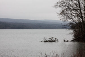
A First Day hike along Canadice Lake.
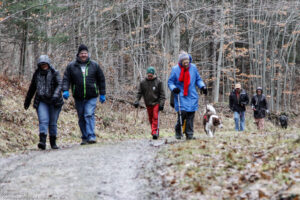
Start the New Year the way you mean to go on – come for an inspiring hike along Canadice Lake! This is an easy, 1.8-mile hike along the shore of the lake; the trail is level and well-maintained and the lake views are lovely. For most hikers it will be a walk along the lake for an hour or so, and then back the same way; more enthusiastic hikers can veer off on Rob’s Trail that leads over the ridge and down to Hemlock Lake – this is a moderate to hard trail with several steep uphill and downhill sections. We’ll take a roll call the day of the hike if anyone wants to walk Rob’s Trail. We’ll arrange for transport back for those who only want to walk one way. Dress appropriately for the weather, carry water and some energy food, and carry a walking pole if it helps. Leashed pets are allowed.
A First Day hike along Canadice Lake.
This is not a “routine” Sunday hike – for a start, it’s happening on a Wednesday! The hike is promoted by the NYS DEC, and is part of a larger program of First Day Hikes to encourage people to get out and experience the magnificent Sate of New York that they live in. As an extra enticement, there will be a raffle at the start of the hike; DEC is giving away a free Empire Pass to one lucky hiker who has the winning raffle ticket. We’ll be giving every hiker who shows up before the 10:00am start time a raffle ticket; naturally, DEC employees and any organizers of the hike will not be offered tickets – that would be way too suspicious!
The Meet-Up Location
All First Day hikers should meet at the parking area off Purcell Hill Road, Town of Canadice, Ontario County. Google Maps (leaves this website)
The Social
There won’t be an organized social on this hike.
Looking for brochure.or mailing list so I can receive it in the mail.
Nothing opens up for mailing list.
There’s all kinds of very bizarre ads and post for viagra and other drugs above on calender page.
Please let me know if there’s a brochure available