
Hikes led by Springwater Trails are generally held on Sunday afternoons and appear in this calendar in green.
Come tour several working farms in Springwater. Open farms will provide tours of their working farms, including demonstartions and equipment.
At the All Western Evergreen Nursery and Christmas Tree Farm, 6840 Liberty Pole Road (County Road 38), the tour will include the farm’s history, tours to different areas of the farm to see differing species of fir trees, demonstrations of tree farming procedures, and a display of equipment.
Hey, the weather predictions were correct – there is snow on the ground and the temperature at 9:00 is only 29° with a predicted high of 33, so we are cancelling the bike ride. BUT, we are hiking, so put on your orange vest and your hiking boots and come enjoy East Springwater by foot!
This Sunday we are offering something different – a bike or hike. (Well, maybe not so special since we are only hiking.) Come enjoy East Springwater either at a walking or a riding pace, according to your preferences.
This hike/bike is a part of the Bicentennial Celebration of Springwater.
Before we start, three cautions:
- This hike will start at our regular winter time of 2:00PM
- If you are hiking please wear orange or another bright color. This will be the second day of regular deer hunting season.
- If the temperature is below 40° then we do not plan to ride. .If you are unsure, please check the website Sunday at noon.
All hikers and bikers will meet at the barn at Punky Hollow near the corner of Pardee Hollow Rd and Tabors Corners Rd in Springwater. As always, please park carefully, as this is private property. Following the hike/bike, please join us for a social at John Larysz’s house. Bring a dish to pass and your beverage, or make a contribution ($5) to the social fund. Thanks John and Sue for volunteering your home.
Hiking above East Springwater
Hikers will hike on Punky Hollow trails. Based on the number of hikers, we will have one or two groups, both of which will follow trails through the woods to the top of the hill to look down on the Cohocton Creek and on Dutch Hollow. As time permits, we will explore the hill top and then return to the cars over a different trail.
Biking Dutch Hollow and Tabors Corners This hike is canceled due to the weather!
Dust those cobwebs off your bike and pump up those tires. Prepare to enjoy the hills of Tabors Corners on two wheels. Yes there will be a few elevation challenges on this ride. We will travel at a leisurely pace, but be prepared for some lovely scenery and a good workout.
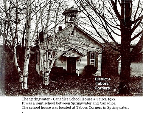
This ride will pass two former school houses in Springwater. Keep your eyes open to School #4 at Tabors Corners and Wetmore, and School # 17 on Pardee Hollow just before the end of the ride.
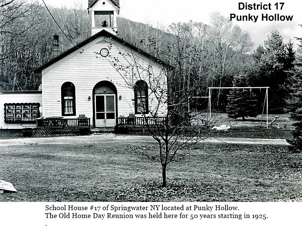 Bikers will meet at the Punky Hollow event building (site of the Fiddlers’ Fair), on Pardee Hollow Rd., ready to ride at 2:00 PM. Riders will head west on Pardee Hollow then north on Tabors Corners Rd. At the junction of Wetmore Rd. we will head north for another mile to reach the town line of Springwater at Tibbals Rd. From there we will head back south on Wetmore turning south on Tabors Corners Rd. The ride continues to Dutch Hollow Rd., which we will follow for about 4 miles back to Pardee Hollow, Turning right we will have a nice downhill cruise back to the parking area. Total distance is 11 miles.
If it the road is snow covered or the temperature is below 40 degrees the ride will be cancelled and we will walk with the hiking group.
From Springwater: Head north on NY 15A from the light in Springwater. Take the first right onto Wheaton Hill Rd. At the Tee at the top of the hill (3.4 mi), turn right onto Wetmore Rd. In 1.2 mi, at the stop sign, turn right onto Tabors Corners Rd. Take the first right in 1.8mi onto Pardee Hollow Rd. The Barn is on the right. Park in the driveway at the far end of the barn, or along the side of Pardee Hollow Rd.
From Wayland: Head east on NY 21 from the intersection with NY 15. in 3 miles, turn left onto CR 37. The road sign says Bowles Corners, although the road name is Tabors Corners. In 3.6 miles, turn right onlo Pardee Hollow Rd The Barn is on the right. Park in the driveway at the far end of the barn, or along the side of Pardee Hollow Rd.
From Honeoye: Head west on NY 20A. Turn left (south) on CR 37 at the Valley Inn. Continue staight onto Canadice Hill Rd in the hamlet of Canadice. In 2.4 miles, Ross Rd goes off to the right, but stay straight to stay on Canadice Hill Rd. .In 2.4 miles of dirt road, the road enters Springwater and the name changes to Wetmore Hill. Continue straight on Wetmore Rd. At the stop sign after going over the hill, turn right onto Tabors Corners Rd. Take the first right in 1.8mi onto Pardee Hollow Rd. The Barn is on the right. Park in the driveway at the far end of the barn, or along the side of Pardee Hollow Rd.
The after hike social at John’s, is just a few turns away on French Hill Rd. Directions will be available at the hike.
Weather Update Based on our pre-hike on Saturday,, we recommend snow shoes or possibly skis if you have them. The snow was 6 or 7 inches deep and it will be easier to be on top of the snow.
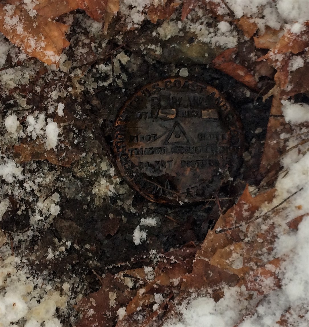 Springwater is home to the highest point in Livingston County at 2244 feet above sea level. You can compare this to the highest point in the surrounding counties. Ontario County (Frost Hill) above Wesley Hill Preserve is 36 feet higher, and Steuben County (Jackson Hill) south of Canisteo is 156 feet higher. On the other hand, Hopper Hill west of Boughton Park in Monroe County is 1200 feet lower.
This Sunday, we will hike on New York State land in the north east corner of Springwater to the actual high point. We will start at the Ontario/Livingston county line on Wetmore Rd at 2000ft and will generally follow the snowmobile trail along the county line and then south through the woods to the highest point. The high point is on private land and we have permission this Sunday to see the actual benchmark placed in 1939. We will then continue south to Dutch Hollow Rd at about 1850ft.
Small portions of this hike will be off the trail, but overall it is not a difficult hike.
We will divide into two groups. The Naturalists/Tourists will primarily stay on the snowmobile trails and will cover 2.4 miles. They will end on Dutch Hollow Rd and we will carpool back to the start point. The Climbers will follow the same route, but will walk back to the cars, stopping to see another benchmark at the corner of Tabors Corners Rd and Wetmore Rd.
Following the hike, join us at John’s home on French Hill Rd. Directions will be available at the end of the hike. Please bring a dish to pass, your favorite beverage and your singing voice. We will do some seasonal singing around John’s piano.
Directions
From Springwater: Head north on NY 15A. In 0.8 miles, turn right onto Wheaton hill Rd. At the tee (in 3.4 miles) turn left onto Wetmore Rd. In 1 mile, park on the left side just before Tibbals Rd.
From Honeoye: Head west on US 20A. Turn left onto CR 37. In 3.7 miles, when CR 37 turns right, continue straight onto Canadice Hill Rd. Continue straight when Ross Rd turns slightly to the right. Go past Harriet Hollister Spencer SRA. At the Springwater Town Line, park on the right just past Tibbals Rd.
From Naples:
(Note that there are seasonal roads between Naples and our hike. If you want to use your GPS (good luck) and take the back roads, head first to the intersection of Garlinghouse and Pardee Hollow. Do not go over Richards Rd, Coates Rd, Liddiard Rd, Warner Rd or Feather St. If you want to get there without incident, follow the directions below).
Take NY 21 S through North Cohocton. Turn right in North Cohocton, to stay on NY 21. In 3.8 miles, turn right onto CR 37 (The sign says Bowles Corners). Stay on CR 37 as it becomes Livingston CR 36 (Tabors Corner Rd) for 5.4 miles until the first stop sign. Turn right onto Wetmore Rd. In one mile, park on the left side just before Tibbals Rd.
Located in Chemung County in the town of Big Flats, Steege Hil is a 794 acre preserve acquired in 2001 by the Finger Lakes Land Trust from an anonymous donor. In 1970, this area was nearly ruined by heavy logging. The Town of Big Flats took action to stop the degradation on the hill by shutting down the operation and passing a law regulating future logging within town limits. Now the original forest is making an impressive recovery. Numerous species of hardwoods prevail, mixed with conifers on the steeper slopes. Wildlife include black bear, timber rattle snakes, and Allegheny Mound Ants. Their distinctive nests can be found trail side and in open areas. For additional information and maps go to http://fllt.org/preserves/steege-hill-preserve
Steward, Bob Corneau has maintained a network of more than 6 miles of trails, mostly over old logging roads. It is our good fortune to be able to enjoy the quiet beauty of these tails on a winter afternoon, Check the Springwater Trails website on February 11 for an update on trail conditions. If there is snow we could ski or snowshoe.
Parking in very limited at this preserve so car pooling is strongly encouraged.
Hike Description
All groups will depart from the parking area on Steege Hill Rd. After a short but steep ascent, our groups will branch out as follows:
Naturalists will follow the yellow loop in a clockwise direction, enjoying some gentler terrain as well as views of the Chemung River and ponds. The ant mounds are numerous on this trail. Out nature experts will no doubt enjoy identifying the many varieties of trees and birds. Hike length will be about 2.5 miles.
Tourists will head our on the yellow loop in a counter clockwise direction, past the ponds and then onto the blue trail to loop through the forest back to the yellow trail. Views of the valley as well as the lower slopes should be nice. Hiking distance about 3.5 miles.
Climbers An ambitious journey awaits you, a complete circuit of the trail system.. This group will veer off from the initial climb to follow the white trail, traversing some significant ups and downs. They will sample the blue and red trails (more hills) before returning home on the yellow loop for about 5 miles. It’s all down hill on the return.
After Hike Social will be at Tag’s Restaurant on Rte, 352 in Big Flats.
Getting There Parking is VERY LIMITED. Roadside parking is not advisable. Please carpool from the Springwater Town Hall, leaving at 12:30. Drive time is about 1 hour 15 minutes.
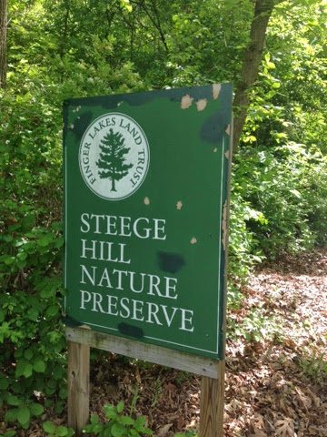 Directions: Take 390 South to I 86 East. Take Exit # 48. Turn Right on NY 352. Go 1.5 miles. Turn right on S. Corning Rd. (Chemung CR 10). Go .7 miles. Just after bridge turn left on Steege Hill Rd. Go 1 mile. Slow down. Parking is on left. Preserve sign is difficult to spot.
Social There is a great little joint called Tags, recommended by local folks. To get there, retrace your steps back to Rte 352. Turn right and travel about 0.6 mile. Restaurant is on the right. Menu is full of salads, burgers, wraps and apps. See it at tagsrestaurant.com
Trail conditions Update 2/11/17. Looks like freezing rain tonight and rain tomorrow. Best bet is to wear waterproof clothing and bring traction control devices/ hiking poles in case conditions are slippery.
Springwater Trails hikers and others may be interested in a number of program presentations (lectures) in the Mount Morris Winter Discovery Series 2017. In March, of particular salience in present day current events, as pertain to the Erie Railroad high bridge (Portage viaduct) spanning the Genesee River and constructon of a replacement bridge for this 140+ year old current trestle bridge, are the March 18th & 25th programs, among other programs of potential interest.
The annually recurrent Mount Morris Winter Discovery Series is offered January through March, on varying theme and topics. Each year holds about one dozen new program presentations.
The Mount Morris Winter Discovery Series 2017, is titled: “Life in America: Winter Discovery Series 2017”. Facilities provided by The U.S. Army Corps of Engineers Mount Morris Dam and Recreation Area, located at the northern end (east side of the Genesee River) of Letchworth State Park. All lectures are free of charge and will be held in the Visitor Center on Saturdays at 1pm. The Visitor Center, aka the William B. Hoyt II Visitor Center, which opened in 1999, is an enclosed heated venue with indoor restrooms and is located adjacent the east side of the Army Corps of Engineers’ Mount Morris Flood Control Dam (which was constructed 1948-1952). Often light refreshments are served at programs of the Winter Discovery Series. [Please note, do not confuse this A.C.E. Visitor Center with the Letchworth State Park – Humphrey Nature Center which is located in Letchworth State Park on the west side of the Genesee River and further south of the A.C.E. Mt Morris flood control dam.]
Mount Morris Dam and Recreation Area Visitor Center is located at 6103 Visitor Center Road in Mount Morris, NY 14510. For more information call (585) 658-4790.
There are numerous exhibits and educational experiences in the Visitor Center, a brief opportunity may exist to view and experience some immediately prior to or after the Winter Discovery Series program. Albeit, the Visitor Center is generally not otherwise open in the winter season.
March 4th program (lecture) LEGACY OF MILITARY SERVICE
Join Steve on a journey of his family’s military connections to conflicts during King Henry IV’s usurpation of the English throne in 1399 to King Philip’s War (1675), the Revolution, War of 1812, Civil War and on to the modern era. Presenter – STEVE CLARKE, Genealogist
Springwater Trails hikers and others may be interested in a number of program presentations (lectures) in the Mount Morris Winter Discovery Series 2017. In March, of particular salience in present day current events, as pertain to the Erie Railroad high bridge (Portage viaduct) spanning the Genesee River and constructon of a replacement bridge for this 140+ year old current trestle bridge, are the March 18th & 25th programs, among other programs of potential interest.
The annually recurrent Mount Morris Winter Discovery Series is offered January through March, on varying theme and topics. Each year holds about one dozen new program presentations.
The Mount Morris Winter Discovery Series 2017, is titled: “Life in America: Winter Discovery Series 2017”. Facilities provided by The U.S. Army Corps of Engineers Mount Morris Dam and Recreation Area, located at the northern end (east side of the Genesee River) of Letchworth State Park. All lectures are free of charge and will be held in the Visitor Center on Saturdays at 1pm. The Visitor Center, aka the William B. Hoyt II Visitor Center, which opened in 1999, is an enclosed heated venue with indoor restrooms and is located adjacent the east side of the Army Corps of Engineers’ Mount Morris Flood Control Dam (which was constructed 1948-1952). Often light refreshments are served at programs of the Winter Discovery Series. [Please note, do not confuse this A.C.E. Visitor Center with the Letchworth State Park – Humphrey Nature Center which is located in Letchworth State Park on the west side of the Genesee River and further south of the A.C.E. Mt Morris flood control dam.]
Mount Morris Dam and Recreation Area Visitor Center is located at 6103 Visitor Center Road in Mount Morris, NY 14510. For more information call (585) 658-4790.
There are numerous exhibits and educational experiences in the Visitor Center, a brief opportunity may exist to view and experience some immediately prior to or after the Winter Discovery Series program. Albeit, the Visitor Center is generally not otherwise open in the winter season.
March 11th NON-TRADITIONAL 19th CENTURY NUNDA WOMEN
As the women’s rights movement gathered strength in the late 1800’s, Nunda women were leaders in business, politics, medicine, art, education, and more. Hear their stories. Presenter – JOAN SCHUMAKER, Local Historian
– – – 2017 Saturday Dates (all program MMWDS dates listed) – – –
Author Arch Merrill described Letchworth Park as the place where Nature touches the Genesee with a magic wand and like Cinderella, the river leaves behind its ordinary garb and dons robes of dazzling splendor. Discover this geological Cinderella — how it came to be and explore the many interactions between man, river, and land. Presenter – JIM POMEROY, Biologist
January14th THE IMPACT OF WWI ON LIVINGSTON COUNTY: Life on the Homefront
In commemoration of the World War One Centennial, this program will provide an overview of the prelude to U.S. involvement and local civilian efforts and sacrifice during the Great War. Presenter – AMIE ALDEN, Livingston County Historian
January 21st SUFFRAGISTS IN EVERY TOWN AND COUNTY: How NY Women Won the Vote
November 2017 marks 100 years since New York State signed woman’s suffrage into law, three years before the U.S. passed the 19th Amendment. This was a milestone for the state and a transformative moment in American democracy. Equal opportunity is as important today as it was when Susan B. Anthony was arrested in Rochester for attempting to vote. Presenter – CHRISTINE RIDARSKY, Rochester Historian
January 28th EARLY WOMEN PHYSICIANS OF THE GENESEE COUNTRY
Did you know that two of the female students and one professor at the first truly co-educational medical school in the country came from the Genesee Valley? Uncover a fascinating story which shows how our region contributed to women’s ability to study medicine alongside men -a radical theory at the time. Presenter – JANE OAKES, Local Historian
February 4th OUR NATIONAL PARKS
Our National Parks have been called “the greatest idea America ever had.” This program covers the background of our National Park Service from its official creation in 1916, but really starts with the formation of the world’s first National Park -Yellowstone. Presenter – CRAIG BRAACK, Allegany County Historian
February 11th THE BURNED OVER DISTRICT
In the 19th century, New Yorkers were gripped by waves of religious revivalism. New groups established churches and utopian experiments all vied for converts. Examine the Shakers, Millerites, Mormons, Spiritualist and Evangelists and the impact that they had on social change. Presenter – PETER WISEBY, Genesee Country Village and Museum
February 18th WATER-POWERED MILLING
Follow the development of water-powered milling from strong beginnings in a new nation to its appearance in the Genesee Valley. We’ll journey through the pioneering discovery of the natural resources of the mighty Genesee River that excited the early American settler to pursue mechanization and industrial innovation. Presenter – ALEX PIERCE, Local Historian
February 25th THE GIANT CARDIFF – America’s Greatest Hoax
A ten-foot tall petrified giant is unearthed on a farm near the small rural town of Cardiff, New York in 1869. The word of the discovery soon ‘echoed’ across the countryside and it was quickly sheltered from the weather by a canvas tent to protect paying gawkers from the whims of New York’s weather. Presenter – RICH HAMELL, Geologist
March 4th LEGACY OF MILITARY SERVICE
Join Steve on a journey of his family’s military connections to conflicts during King Henry IV’s usurpation of the English throne in 1399 to King Philip’s War (1675), the Revolution, War of 1812, Civil War and on to the modern era. Presenter – STEVE CLARKE, Genealogist
March 11th NON-TRADITIONAL 19th CENTURY NUNDA WOMEN
As the women’s rights movement gathered strength in the late 1800’s, Nunda women were leaders in business, politics, medicine, art, education, and more. Hear their stories. Presenter – JOAN SCHUMAKER, Local Historian
March 18th LIFE IN THE LAND OF LETCHWORTH FROM NATIVE TIMES TO MODERN DAY
People have lived along the Genesee River for thousands of years. Join Tom as he explores life in the Valley through local stories, maps, photographs, diaries, and more. Highlights include the experiences of the Jemison family, early pioneers, the Letchworths, and some 20th century park families. Presenter – TOM COOK, Local Historian
March 25th The ROLE OF CAMP PORTAGE AND THE ERIE RAILROAD IN THE AMERICAN CIVIL WAR
Learn about the creation of Camp Portage (a Civil War Training Camp in Letchworth State Park) and the use of the Erie Railroad to transport Union Soldiers to the front lines! Presenter – MAX SZEMPLENSKI, Railroad Historian
Have you ever pondered about the “Parade Grounds” area in Letchworth State Park? What’s with the name and what is the history of the area? Perhaps you’ve hiked & spent time there. Well, read on for some answers.
The last program in the weekly Mount Morris Winter Discovery Series 2017 (MMWDS) serial of programs will be presented as follows:
“March 25th The ROLE OF CAMP PORTAGE AND THE ERIE RAILROAD IN THE AMERICAN CIVIL WAR
Learn about the creation of Camp Portage (a Civil War Training Camp in Letchworth State Park) and the use of the Erie Railroad to transport Union Soldiers to the front lines! Presenter – MAX SZEMPLENSKI, Railroad Historian”
Of note, Camp Portage and the nearby Erie RR (both of yesteryear) are in today what we know as Letchworth State Park, in the area and surrounds known today as the “Parade Grounds”. – – Some salience specifically of current events is: Sprinwater Trails hikers have on a number of occasions hiked in this area on some weekly scheduled Sunday hikes, and the 140+ year old Erie RR bridge which spans high above the Genesee River within Letchworth State Park currently has a replacement being built which will decommission the aging bridge.
The bridge, aka viaduct, has been subject of much attention as of late both in media postings and in program presentations put on for benefit of those in the community who have interest in the bridge and history. One such program was sponsored by Penfield Trails Committee (PTC) on Saturday, February 11th, 2017 as part of PTCs annual Hikers Jamboree program. Following the PTC sponsored program which was presented at Penfield Town Hall Auditorium, there where hikes in Penfield. Both Springwater Trails and Genesee Valley Hiking Club participated in leading such hikes.
– Excerpts of a Springwater Trails website previously posted article on topic of the MMWDS 2017 are:
Springwater Trails hikers and others may be interested in a number of program presentations (lectures) in the Mount Morris Winter Discovery Series 2017. In March, of particular salience in present day current events, as pertain to the Erie Railroad high bridge (Portage viaduct) spanning the Genesee River and constructon of a replacement bridge for this 140+ year old current trestle bridge, are the March 18th & 25th programs, among other programs of potential interest.
The annually recurrent Mount Morris Winter Discovery Series is offered January through March, on varying theme and topics. Each year holds about one dozen new program presentations.
The Mount Morris Winter Discovery Series 2017, is titled: “Life in America: Winter Discovery Series 2017”. Facilities provided by The U.S. Army Corps of Engineers Mount Morris Dam and Recreation Area, located at the northern end (east side of the Genesee River) of Letchworth State Park. All lectures are free of charge and will be held in the Visitor Center on Saturdays at 1pm. The Visitor Center, aka the William B. Hoyt II Visitor Center, which opened in 1999, is an enclosed heated venue with indoor restrooms and is located adjacent the east side of the Army Corps of Engineers’ Mount Morris Flood Control Dam (which was constructed 1948-1952). Often light refreshments are served at programs of the Winter Discovery Series. [Please note, do not confuse this A.C.E. Visitor Center with the Letchworth State Park – Humphrey Nature Center which is located in Letchworth State Park on the west side of the Genesee River and further south of the A.C.E. Mt Morris flood control dam.]
Mount Morris Dam and Recreation Area Visitor Center is located at 6103 Visitor Center Road in Mount Morris, NY 14510. For more information call (585) 658-4790.
There are numerous exhibits and educational experiences in the Visitor Center, a brief opportunity may exist to view and experience some immediately prior to or after the Winter Discovery Series program. Albeit, the Visitor Center is generally not otherwise open in the winter season.
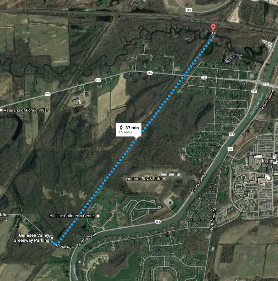 Today’s hike is an easy, flat trail with cinder surface, crossing an historic double-arched Genesee Valley Canal (GVC) culvert.
Meet at the Brook Rd Genesee Valley Greenway (GVG) Parking area. Total distance out and back is 3.7 miles.
For more information, check the Friends of the Genesee Valley Greenway (FOGVG) website, their Passport page, and the complete 2017 GVG Passport Series.
– – – Additionally, the Genesee Valley Greenway State Park (GVGSP) Facebook page usually lists the upcoming GVGSP events, and the FOGVG Facebook page also lists numerous GVG events in our area albeit a greater proportion of events listed on this page may at times be in the “Southern Tier” portion of the GVG as planned by a group of hikers known as the Southern Tier Greenway Hiking Group (STGH or STGHG) who welcomes all to hike with them.
– – – We also have a short history of the Greenway.
(subnote: The historic double-arched Genesee Valley Canal culvert (aqueduct) is best viewed for picturesque value from points other than on the GVG itself. As attested to by on-site GVG signage, the culvert/aqueduct, later turned viaduct for the railroad and subsequently the GVG, conducted the GVC over Black Creek. A great photographic vantage point is offered while on Black Creek in a kayak/canoe/boat. At low water levels you may be able to paddle Black Creek under the GVG to view both sides of the historic culvert , but at high water levels … well, not so.)
So, you’ve been itching to get on your bike this Spring with impetus of a group bike outing of some kind. Well, here is an opportunity to do just that … on the Genesee Valley Greenway (GVG) from Avon to York Landing (round trip) on Saturday May 20th, 2017 at 10:00AM. Approximately a 17 mile round trip easy paced bike ride, and all trail mileage covered is in the nw corner of Livingston County. Meet location is at the Erie-Attica Trail (EAT) trailhead in Avon, accessed by Farmers Road off Rts 5&20 just east of the Genesee River.
– – – A digression – – Speaking of itching, this Hike Planner has had impetus to utilize the section of the GVG shortly north of Fowlerville Rd (and south of US Rt 20), said section has a short duration of trail topped with thick stone dust (mostly fine stone sans dust), for a ST hike since early Spring 2016 just following reconstruction of said section of trail which had been necessitated as result of a huge washout area. The thick stone dust topper (as determined during a potential preview hike in April 2016), provided wonderful cushioning upon a hikers joints, albeit bike/stroller/wheelchair wheels found much friction/consternation due to sinking in the freshly laid thick topper surface.
Due to complaints of wheeled trail users, later in 2016 the topper surface was rolled by a heavy duty roller to make for some compaction factor, and the surface is said now to be kinder to the aforementioned narrow wheeled vehicles (and probably offers less of an exuberant opportunity for a hiker’s joints). If there is a lesson here, perhaps it is that not all opportunities are lasting, some have but a small window of opportunity. Still, a future ST hike planned to utilize this section of the GVG may offer multiple unique opportunities including this now somewhat tamed section of thick stone dust topper.
Anyway, you’ll get to see this short section and so much more of the GVG via your bike on this traverse much more quickly than while on a hike. – – –
(A further digression, …for the curious, … utilization of the aforementioned section of trail south of US Rt 20 was in consideration for the 4/24/2016 ST hike, but ultimately was scrapped from the fledgling Hike Plan due to what would have been a controverted driving route to reach the GVG trailhead parking lot on US Rt 20, all thanks to road reconstruction on US Rt 20 just east of the GVG trailhead. -Now you know – substantially trials and tribulations that weighed in nixing this unique section of trail south of US Rt 20 for the 4/24 ST hike, … instead all hiking groups headed north from Avon.) – – – End of digressions. – – –
GETTING THERE:
From just inside Avon’s western town limits, to reach the Erie-Attica Trail parking lot & trailhead follow Farmers Rd to the end where you’ll find both the parking lot & the trailhead. – – – Seem familiar? Well, ST has in the past (10/18/2015 hike) held a hike utilizing exactly this trailhead and parking lot, as well as parts of the connecting GVG, so yes, it may seem familiar. And an April 24th 2016 ST hike also utilized the GVG in this area.
Detailed Directions From Springwater: Take Rt 15A North. In Lima, turn left on US Rt 20 (concurrent NY Rt 5, thus known as Rts 5&20). Follow Rts 5&20 for 7.6 miles (you will cross over I-390, pass through the hamlet of East Avon and the Village of Avon. After the traffic circle in the village, continue on Rts 5&20 for 0.8mi and turn right on Farmers Rd. The parking area is on the right, just after you pass under the flyover for the former RR truss bridge (now the Erie-Attica Trail truss bridge).
Further Event Details for this May 20th biking event are listed on the FOGVG Facebook page.
GVG Passport Booklet: This bike ride will cover a stretch of trail where you’ll be able to avail yourself of making a rubbing in the Wegman’s Passport to Family Wellness – GVG passport booklet. For those unfamiliar – – – Wegmans – “Passport to Family Wellness Program” series booklet for the Genesee Valley Greenway is a passport compilation of 14 separate hikes on the GVG, each hike route having a “rubbing post” for trail users to produce a “rubbing” in their passport booklet with purpose of documenting that a trail user has completed the respective hike. Passport booklets filled-in with rubbings can be turned in at a Wegmans retail store for redemption of coupons for Wegmans brand products and entry for a prize drawing. So, remember to bring your GVG passport booklet on this bike ride.
(Event post initially published on 5/7/2017, updated 5/17/2017.)
Genesee Valley Greenway State Park (GVGSP) Passport Hike Series–Brook Road to Morgan Road–Wegmans Hike #3
Saturday, June 10, 2017 at 10:00 AM
Brookdale Preserve, on Brook Road, Scottsville, NY
The GPS Coordinates: N43 04.577 W77 42.550
Meet at the Brook Rd Genesee Valley Greenway (GVG) Parking area.
The hike will be going southward from the Brook Road parking lot along the eastern edge of Brookdale Preserve. We will see remnants of the Genesee Valley Canal and the well preserved Lock #2.
The hike leader is Elijah Kruger from the educational staff of Letchworth State Park. The hike distance is 4.3 miles round trip. The Genesee Valley Greenway State Park is hosting this hike. There is no charge to attend this hike. Therefore, please consider joining us.
For more information, check the Friends of the Genesee Valley Greenway (FOGVG) website, their Passport page, and the complete 2017 GVG Passport Series.
– – – Additionally, the Genesee Valley Greenway State Park (GVGSP) Facebook page usually lists the upcoming GVGSP events, and the FOGVG Facebook page also lists numerous GVG events in our area albeit a greater proportion of events listed on this page may at times be in the “Southern Tier” portion of the GVG as planned by a group of hikers known as the Southern Tier Greenway Hiking Group (STGH or STGHG) who welcomes all to hike with them.
– – – We also have a short history of the Greenway.
Looking for brochure.or mailing list so I can receive it in the mail.
Nothing opens up for mailing list.
There’s all kinds of very bizarre ads and post for viagra and other drugs above on calender page.
Please let me know if there’s a brochure available