
Hikes led by Springwater Trails are generally held on Sunday afternoons and appear in this calendar in green.
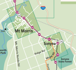 Springwater Trails (SWTs) will join the Friends of the Genesee Valley Greenway (FOGVG) for the events they have planned for their Hike, Bike, Program, Dinner and Annual Meeting. Below is the information posted on their website. SWTs is adding one additional option for our hikers – climbers can meet at 1:00 at the pull off south of the Village of Mount Morris on Route 36 just north of Swanson Road. They will then hike 3.6 miles on the Greenway to the parking area in Sonyea State Forest and then along Keshequa Creek as time allows. The “out and back walk” described below is recommended for SWT Naturalists and Tourists. Meet at the VFW parking area behind their building at 3 Elm St. in downtown Mt. Morris at 12:00.
Please note, hikers going all the way to the end and those electing the “out and back” option need to register with Irene Szabo to assure that she knows how many hikers need rides and that there are enough vehicles at the destination point. To register with Irene, email treeweenie@aol.com, or call at 585/658-4321
FOGVG Events in Mt. Morris-Sonyea: Hike, Bike, Program, Dinner & Meeting
WHEN: November 12, 2017 all-day
WHERE: VFW Building
3 Elm St. Mt. Morris NY
CONTACT:
Joan Schumaker
585-490-3302
Experience hiking or biking the Greenway in Mt. Morris and on the newly opened Sonyea section.
Travel 7.25 mi. by starting at the Pocket Park at the Greenway Bridge over the Genesee River or reduce length by starting at one of the new Greenway Parking areas in Mt. Morris, the last official GVGSP parking areas for this event. There is absolutely no parking near the prison area in Sonyea.
At 4.9 miles, turn right, west, across NY 36 into Groveland Correctional grounds, staying strictly on the paved route marked with green on white Greenway signs. After end of old brick buildings, climb gently on dirt road. Mile 6 is the approximate end of prison property with metal gate, and entry into Sonyea State Forest. At first continue west on old dirt road past bushy thickets that once were farms and vineyards. This whole 1670 acre property owned by the state came from a “Shaker” colony and was eventually divided between the Dept. of Corrections and the State Forest. Soon come to a T-intersection; turn RIGHT on the road and descend into forest, then curve left to stay with road until a big parking area at 7.25 miles that is the pick up point. For a ride back to your cars, you need to plan your hike or ride to arrive at this destination by 3:30 pm.
There is also a 4 mi. option for an “out and back walk” of new Greenway route within the Correctional Facility and Sonyea State Forest, with potential for optional side foray into the Keshequa Creek valley where the original canal and railroad used to run. Meet at the VFW parking area behind their building at 3 Elm St. in downtown Mt. Morris at 12:00, in the first block off Main Street going south. This group will caravan to the State Forest and provide rides back to Mt. Morris for the long distance hikers at 3:30 pm.
All participants in the above options should bring water and any food they will need. Hikers going all the way to the end and those electing the “out and back” option also need to register with Irene Szabo to assure that we know how many hikers need rides and that we have enough vehicles at the destination point. To register with Irene, email treeweenie@aol.com, or call at 585/658-4321
The program, dish-to-pass dinner, and FOGVG meeting take place at the VFW building at 3 Elm Street. Refrigeration and ovens are available. At 4:30 pm, Pat Coate from Allegany, NY will present a most interesting program on “Hiking the Appalachian Trail.” Dinner will follow at about 5:30 pm. Please bring your own table service and food to share. The brief Annual Meeting will take place after dinner.
Everyone is invited. Take part in one or more of the above events. Why not join us for all of them.
Description
This preserve, maintained by the Finger Lakes Land Trust, is a perfect refuge during hunting season. In fact, our hikers will be performing a service to the land trust by patrolling the woods as they walk. Steege Hill is about 800 acres acquired in 2001 from an anonymous donor. The forest is regenerating after heavy logging in the 1970’s and contains many species of hardwoods. The 6 miles of trails are constructed largely on the old logging roads. On some of the steep slopes original hardwoods and conifers still remain. From its hilltop vantage point, there is a bird’s eye view of the Chemung River. Worth mentioning are two notable creatures that inhabit this woods. Timber Rattlesnakes have long been residents here, especially on the sunlit rocky outcroppings. They may be snugly out of sight this time of year. The nests of Allegheny Mound Ants are common sight, trailside and in clearings. Black bears like it here too.
Hike Groups
Lets hope the weather conditions are more favorable than last year’s wet and snowy visit to Steege Hill. All groups will depart together from the parking area, heading uphill for about 1/2 mile on a moderate pitch. There are 4 trail loops to explore.
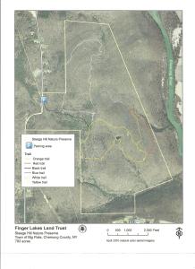
Naturalists will cruise around the Yellow Loop, about a 2 mile jaunt with a few small inclines and a pond. A volunteer leader is needed for this group.
Tourists will traverse the blue and orange trails, enjoying a variety of terrain with some moderate climbs, about 3.5miles. A volunteer leader will also be needed for this group.
Climbers will tackle the white and red trails which offer some up and down hill changes as well as a nice valley view. Distance is about 4.5 miles.
Hopefully all groups will arrive back at the starting point at approximately the same time.
Parking space at Steege Hill is limited. Carpooling is highly recommended. Meet in Springwater at the Town Hall on Route 15 at 12:45 as the drive is about 1 hour.
Directions take 390 south to I 86. Take exit 48 then follow Rt 352E for 1.5 miles. Turn right on South Corning Rd. for .7 miles. After crossing bridge across Chemung River, turn left on Steege Hill Rd. Follow for 1 mile. Preserve is on left.
After Hike Social will be at Tags Restaurant, 3037 Rt 252 in Big Flats. It is a very short drive from the hike. Good food. We have been there previously.
Description
This preserve, maintained by the Finger Lakes Land Trust, is a perfect refuge during hunting season. In fact, out hikers will be performing a service to the land trust by patrolling the woods as they walk. No worries. In sixteen seasons, patrollers have never encountered a hunter.
Steege Hill Preserve is about 800 acres, acquired in 2001 from an anonymous donor. The forest is regenerating after heavy logging in the 1970’s and contains many species of hardwoods. Preserve steward, Bob Corneau, has maintained a network of over 6 miles of trails, constructed largely on the old logging roads. On some of the steep slopes original hardwoods and conifers remain. From its hilltop vantage point there is a bird’s eye view of the Chemung River.
Worth mentioning are two notable creatures that inhabit this forest. Timber Rattlesnakes have long been residents here, especially on the sunlit rocky outcroppings and in the shade of the forest. They may be snuggly out of sight at this time of year, but be cautious when stepping off the trail. The distinctive nests of Allegheny Mound Ants are a common sight at trailside and in clearings that the ants have fashioned for themselves by destroying shade plants to insure adequate sunlight and warmth for the colony. Black bears also have been sighted in the area recently. For more about this preserve go to http://fllt.org/preserves/steege-hill-preserve
Hiking Groups
All groups will depart together from the parking area on Steege Hill Road, heading uphill for about a half mile on a moderate pitch. There are four trail loops to explore.
Please note: The parking space is very limited. Carpooling is highly recommended. Meet at Springwater Town Hall on Route 15 at 12:45 as the drive is 1 hour.
Naturalists will cruise around the Yellow Loop, a gentle 2 mile jaunt with a few small inclines and a tranquil pond. We may be fortunate enough to have the steward of the refuge join this group. If not, a volunteer leader is needed.
Tourists will traverse the blue and orange trails, enjoying a variety of terrain with some moderate climbs, about 3.5 miles. A volunteer leader will be needed for this group.
Climbers will tackle the white and red trails which offer some up and downhill challenges, as well as a nice valley view. Distance is about 4.5 miles.
Hopefully all groups will arrive back at the starting point at approximately the same time.
Directions From Springwater, take I 390 south to I 86 E towards Corning. Follow I 86 east to exit 48, then follow Rt.352 east for 1.5 miles. Turn right on South Corning Rd. for .7 miles. After crossing bridge across the Chemung River, turn left on Steege Hill Rd.. Follow up hill for 1 mile. Preserve is on the left. Look for green and white sign.
Social will be at Tag’s Restaurant, 3037 Rt 252 in Big Flats, It is a very short drive from the hike. Good food. We have feasted there previously.
Spring is here!, and it is time to get outside. The Finger Lakes Land Trust is sponsoring a volunteer opportunity at Wesley Hill. This is an opportunity for Springwater Trails to say thank you to one of our popular hike locations.
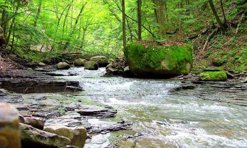 Wesley Hill is one of FLLT’s most iconic nature preserves, and on Monday, May 20th, it will be turning 20 years old! If you have never visited our westernmost preserve, this is your chance! Wesley Hill is full of beautiful vistas, gorges, and old growth trees.
Please join me on Saturday the 18th to help refresh the hiking trails and clear a short reroute, as well as conduct habitat management. At the end of the day, we will raise a glass of something bubbly to a magnificent place that is protected forever. Tools, work gloves, and refreshments (including N/A options), will be provided. We will meet at 11:00am at the WESLEY RD. parking area. Directions can be found here.
Original email from:
Jason Gorman, Nature Preserve Manager
Finger Lakes Land Trust
202 E. Court Street
Ithaca, NY 14850
607.275.9487
www.fllt.org
This hike is CANCELLED!!!!! The freezing rain across the region is too dangerous for both driving and walking!
Description
- This 800 acre preserve is a sanctuary for hikers during hunting season. It was acquired by the Finger Lakes Land Trust in 2001 with generous help from an anonymous donor. A stipulation of this gift was that the preserve would be patrolled during hunting seasons to protect against trespassers. Our hikers will contribute to this effort.
The hilltop preserve looks down upon the Chemung River between Corning and Elmira. At one time this area was nearly ruined by heavy logging, but the town of Big Flats stepped in to halt the destruction. The original forest has made an impressive recovery through natural regeneration of many tree species. On some of the steep slopes, original hardwoods and conifers remain.
Some forest residents are worth noting, although in December they are not likely to be visible. Timber rattlesnakes are long time residents here. Allegheny mound ants have also carved a niche. Black bears have been sighted in recent years. For additional information and history go to http://fllt.org/preserves/steege-hill-preserve
 Special Note: Although no hunters have been spotted here in all these years, please make yourself visible by wearing blaze orange. Conditions in December are unpredictable. It is advisable to bring hiking poles and traction devices for your boots.
The 6 miles of trails are largely old logging roads, well marked and maintained. All hikers will gather at the new and improved parking area on Steege Hill Rd, which has been recently repaved. It is still a small area so carpooling is encouraged. Meet at Springwater Town Hall on Rt. 15 at 12:45 to share a ride for the 1 hour drive to Big Flats.
Hiking Groups There is a moderate half mile climb from the parking area to the various trailheads.
Naturalists will enjoy meandering for about 2 miles along the yellow trail with its gentle slopes and a scenic pond. A hike leader will be needed for this group. Trail map will be provided.
Tourists will traverse the blue and orange loops for about 3.5 miles, enjoying a variety of terrain and some nice views. Uphills are moderate. A volunteer hike leader is needed for this group.
Climbers will tackle the red, white, and blue trails for a distance of about 4.5 miles with some up and downhill challenges.Directions Take 390 South to I86E.
Follow I 86 E to exit 48.
Take 353 E for 1.5 miles
Turn right on South Corning road and go .7 miles.
Cross Chemung River and turn left on Steege Hill Rd.
After 1 mile look for preserve sign on left.
After Hike Social will be at Tags Restaurant, 3037 Rt. 352 in Big Flats. We have enjoyed dinner here several times. See menu at http://www.tagsrestaurant.com
The Genesee Valley Greenway is asking for ideas on needed enhancements along the Greenway. This will be an open workshop aimed to hear your suggestions for the park and how it might improve your communities. There is a series of two open workshops, with the first on February 7th in Cuba NY. Please check the Friends of the Genesee Valley Greenway for more information.
 Based on the latest COVID-19 New York State on PAUSE announcement, we expect to cancel Sunday’s trail maintenance. Please check back here tomorrow for our final decision.
The Annual Meeting scheduled for Sunday 22nd March is deferred to later in the year; instead, the walk this Sunday will be a maintenance hike of our section of the Bristol Hills Branch of the Finger Lakes Trail in Naples. Springwater Trails has signed up with the FLT to maintain this part of the trail. This segment passes through the West Hill Preserve off Seman Rd and then across private land to Mt Pleasant Street in Naples. The Twisted Branch Trail Run comes over this section later in the year; a couple of hundred runners will be pounding the hill and we want to be sure the trail is safe and fun to run.
We will walk this stretch of the BHB and cut away any brush and weeds that have overgrown the trail. The most useful tools for this are lopers and a small saw. It’s too early in the year to whack the long grass and we’ll note work that needs a chain saw for later treatment. Be sure to wear good work or gardening gloves. It’s a fairly long hike and steeply downhill at the Naples end of the walk.
We will meet at the entrance to the West Hill Preserve on Seman Road (42.66166, -77.396288). We will shuttle some cars down to the hike end in Naples (42.625950, -77.397304) before we start. The climbers will follow the trail down to the old cemetery in Naples. Naturalists follow the trail to the sign in box and then return to the cars on Seman Road.
Please note: Dogs are not allowed to hike on the Nature Conservancy property.
The Social
There won’t be an organized social in deference to the current fear of corona virus contagion. However, anyone who is brave enough and thirsty enough at the end of the hike will find us at Roots if they are still open.
Directions to the Hike Meeting Point:
From Springwater: Head south on NY 15 (for 5.2mi). At the light in Wayland turn left on NY 21N (for 6.7mi). In N Cohocton, turn left to stay on NY 21N (for 4.5mi). In Naples, turn left again to stay on NY 21N (for 1.8mi). On the north side of Naples, turn left on CR12 and head up the hill for 1.9 miles. Take the first left, Rhine St., to the 4 way intersection. Go left onto Seman Rd. Trailhead is about 1/2 mile, by a big sign on the left. Park along the road.
From Honeoye and Naples: Head south on CR 36 on the west side of Honeoye Lake (it’s 13.6 miles from NY 20A, and 1 mile from French Hill Road). Turn left onto Gulick Rd (for 2 mi), then right on Davis Rd (for 0.7mi). At the end of Davis, turn left on W Hollow Rd (CR 33) for 0.5mi, then right on Seman Rd. The Trailhead is about 1 mile, by a big sign on the right. Park along the road.

Looking for brochure.or mailing list so I can receive it in the mail.
Nothing opens up for mailing list.
There’s all kinds of very bizarre ads and post for viagra and other drugs above on calender page.
Please let me know if there’s a brochure available