
Hikes led by Springwater Trails are generally held on Sunday afternoons and appear in this calendar in green.
Open Bicentennial planning meeting. Everyone is welcome.
Meet at the designated locations by 9:30.
April 25th. Meet at the New Covenant Baptist Church Parking lot on County Road 46. Hike Main St to CR 46. (3mi)
May 9th. Meet at the New Covenant Baptist Church Parking lot on County Road 46. Hike CR 46. to Depot Road (5mi)
June 6th. Meet at Depot Road. Hike Depot Rd to Stanley Junction (3.8mi)
July 11th. Meet at BOCES parking lot. Hike Stanley Junction to Boces (3.5mi)
August 15th. Meet at the Orleans water tower. Hike Boces to Orleans (4.5mi)
September 12th. Meet at Rt 96 trail head. Hike Wheat Rd to Rt 96 (3.8mi)
October 10th. Meet at Gifford Rd. Hike to Wayne county line and back (3.6mi)
You can download a PDF with more information.
Founder’s Day is Sunday, April 17 and will be celebrated with several activities at the Springwater Fire Hall (8145 South Main Street), including an interdenominational worship service from 10:00 to 11:30 a.m. followed by a chicken barbecue, and, at 1:00 p.m., a special dedication ceremony attended by Senator Catharine Young and several other county and state officials.
See the original declaration here. Springwater is created by Law
Contact: Judy Tripp-Neu at 669-2683.
On Sunday, we are hiking between three cemeteries in Springwater, including the Green Gull Cemetery and the Pleasant Valley East Cemetery. In between, we will visit a surprise cemetery tucked into the hills of Springwater. All three cemeteries are noted on the 1872 Atlas of Livingston County. Click on the detailed map below to see the complete map of Springwater. The complete Atlas of Livingston County, New York, published by F. W. Beers & Co in 1872, is available on-line.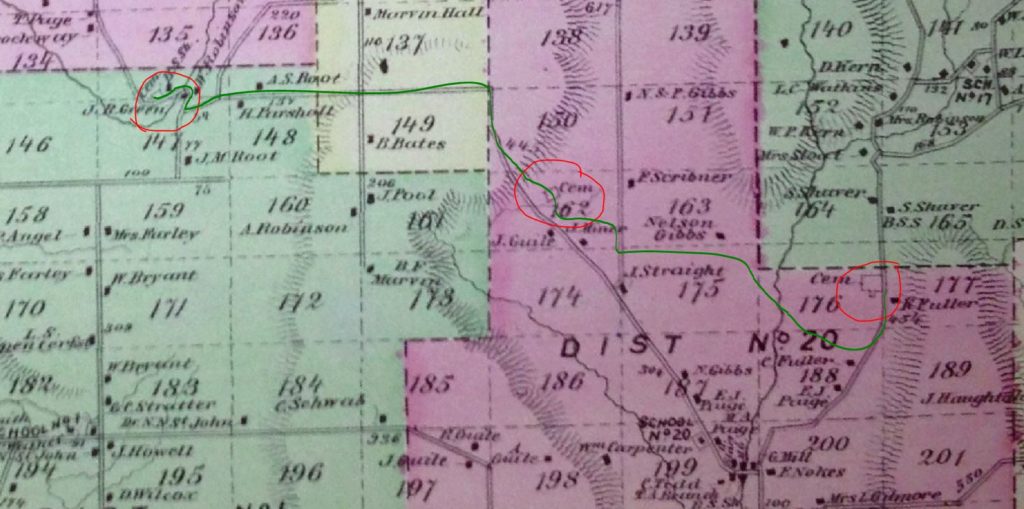
We will meet at 8664 Schribner Rd and carpool to the first cemetery.
Following the hike, join us for a pot luck social on Schribner Rd. Bring a dish to pass and your own beverage, or make a small $5 donation to the social fund.
Three hikes are planned. The Naturalists will carpool about 2 miles west to Green Gull Cemetery on Canadice Rd near Strutt St. This is a small cemetery above the road with graves of two veterans of the Revolutionary War. After exploring the cemetery, the Naturalists will follow Canadice Rd to Strutt St and climb Fox Rd to the top (about a 400 foot climb. From there we will follow the old Gilles Rd as laid out on the 1872 map to the second cemetery. From there we will follow trails through the woods and back to the starting point. This will be a 2 mile hike with both a climb up and down.
The Climbers and Tourists will carpool east to the Pleasant Valley Cemetery (East) on Tabors Corners Rd. This cemetery is also known as the East Springwater or The Fair View Cemetery and it contains graves of one War of 1812 veteran and 19 Civil War veterans. After exploring the cemetery, we will follow a farmer’s road across the Cohocton Creek, and up a steep climb to the fields above the Schribner Valley. The trail crosses Schribner and continues up along Giles Rd to our second cemetery. From there the Climbers will continue down Fox Rd to the Green Gull Cemetery. As they pass the Naturalists going the other direction, they will collect keys to the Naturalists cars to return to the start point. The Tourists will turn around at the second cemetery and follow the same route as the Naturalists back to the start point and the Social. A driver will be available to take drivers back to the Tabors Corners cemetery to pick up cars.
A note about the weather: The forecast calls for temperatures in the 40s and showers between 2 and 6 on Sunday. So dress warmly and bring a raincoat or poncho. Lets hope the forecast is off by a few hours.
Directions to the meeting place are available here. Directions for the hikes and the carpools will be available the day of the hike.
The Western Finger Lakes chapter of the NY Forest Owners Association is holding their Spring General Meeting on May 18.
A panel of leaders from local business, non-profit and government will talk about the tourism industry in the area and how forest landowners can participate in the economic benefits of attracting people to the area.
The Game of Logging is the premier chainsaw training course and is highly recommended for anybody who uses a chainsaw. Level 1 is open to all, regardless of their experience, and will be offered on Saturday, 04 June, and Monday, 06 June. Level 2 is open to people who have taken level 1 and will be offered on Sunday, 05 June. You may register for both level 1 on Saturday and level 2 on Sunday. These classes are hosted by the Genesee County Department of Parks, Recreation and Forestry and the WFL chapter of NYFOA. The cost of the program is subsidized in part by the New York Center for Agricultural Medicine and Health (NYCAMH). Registration is required and is done through NYCAMH at (800) 343 7527 x2204. Further information is available at www.gameoflogging.com and www.nycamh.org.
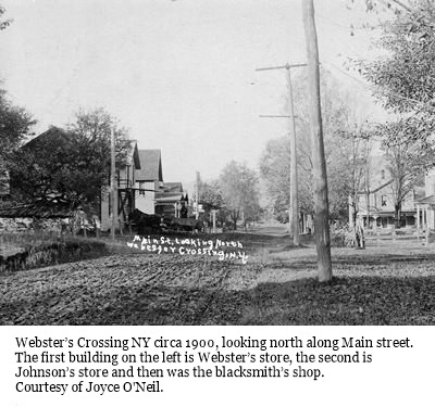 Our first Bicentennial Hike explored the Hamlet of Springwater back in April. This month we are going to explore Webster Crossing, the other hamlet in the Town of Springwater.
We will be meeting at Webster Crossing United Methodist Church, (Route 15, Webster Crossing Road, Springwater, NY 14560) at 4 p.m, The hike will start with a walking tour of Webster Crossing then break up into groups, depending on the distance comfortable for those who are attending. Suggested map routes for the Climbers, Tourists, and Naturalists will be provided.
We will be walking the Morris Road, Story Road, and the All Western Evergreen Tree Farms and other farm and homeowner’s properties depending on permission obtained. More details day of the hike.
The dish-to- pass social will be at the Webster Crossing Church where Gladys Weed, hamlet historian and retired postmaster, will have the history of the hamlet in photos and will be on hand to answer any questions.
Directions:
From Springwater and Wayland: Follow NY 15 north from Wayland to the flashing light in Springwater. Turn left to stay on NY 15. In 3.6 miles, the church is on the left.
From Rochester: Take I-390 South to Exit 9 – Lakeville. Turn left onto NY 15 south. Stay on NY 15 for 16.1 miles to Webster Crossing. The church is on the right.
Please note: For this hike, other routes recommended by your favorite routing tool are also available, and will get you to the church (42.669608, -77.635264) on time. Just enter the GPS coordinates and drive with confidence.
Looking for brochure.or mailing list so I can receive it in the mail.
Nothing opens up for mailing list.
There’s all kinds of very bizarre ads and post for viagra and other drugs above on calender page.
Please let me know if there’s a brochure available