
Hikes led by Springwater Trails are generally held on Sunday afternoons and appear in this calendar in green.
Every fall, Trail Maintenance and Trail Quality hold two meetings for trail maintainers and any other interested parties. One of the meetings, intended for hikers or workers on the main trail between Portageville (M 7) through Watkins Glen (M 14), the Letchowrth, Bristol Hills, or Crystal Hills Branches and the Queen Catharine
Marsh and and Montour Falls Historic Loops, will be held at the Bath Fire Hall.
Each meeting will be informed by your specific questions and the problems you have encountered, but both will include about any trail management policies which you need to be familiar with. This years meeting will feature Marty Howden, Western Regional Coordinator for the FLTC and Coordinator of the Chainsaw Training. Marty and Lynda Rummel, FLTC VP for Trail Quality, will talk about the status of the NPS & USFS chainsaw and cross-cut saw certifications and the increased emphasis on working safely in the field.
Who should attend? All hikers who enjoy the Finger Lakes Trail system including Springwater Trails members who wish to help maintain the Bristol Hills Branch.
For more information, please see the full meeting announcement.
10 AM sharp. Bring your lunch, your questions, and your ideas. Coffee, apple juice and some breakfast goodies provided.
Directions:
From Springwater: Take Rt 15 South for 6.9 miles. Turn left to merge onto I-390 South for 20.2 miles. Take exit 38 from I-86 (Rt 17) for Bath. Turn left onto W Washington St. Turn right at the 2nd cross street on W Morris St. The firehouse is on the left about a half mile down Morris St (past Pulteney Park). Parking is available behind the fire house.

Overlook (Honeoye Lake Harriet Hollister Spencer (1887-1962) was born in Rochester, NY. She was a Charter Member of the Rochester Garden Club and was known as a rose expert. She designed the Garden of Fragrance at the Rochester Museum and Science Center and contributed roses from her own garden. In 1963, her family donated, at her request, 679 acres of land to New York State for the Harriet Hollister Spencer State Recreation Area.
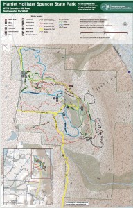 At 2000 feet, this park generally receives and keeps a good covering of snow each winter, and is one of four parks groomed for cross country skiing by the Rochester XC Ski Foundation.
Following the hike, an optional social will be at Sammy’s in Springwater.
The Naturalists will follow Bear Cub Run from the parking area to the snow shoe trail S6 just down the hill from the road. They will cross the overlook, cross Racoon Run, and then will make a short steep hike up to the loop at the end of the road. Then the Pines and Bypass trails will return to the parking area. Depending on the time, a hike to the north around the Big Oak trail may be possible.
The Tourists will similarly follow Bear Cub to the snow shoe trail, but will turn left on Racoon Run. Next is a left for a quick Fox Run loop, back to Racoon Run. Take the next left down to Lower Sidewinder, and follow that loop in a clockwise direction. At the information sign, we will stay to the left to follow a snowshoe trail across the snowmobile trail out toward Canadice Hill Rd and back. From their, heading north on Blue Spruce Run, Whiteface, and Cannonball, will bring us back to the road and the parking area.
The Climbers will follow Bear Cub Run to the road, and then will cross the road to follow the bypass and Chalet trails to the snowmobile trail. From there, we will follow the snowmobile trail south for about 2 miles, crossing into the town of Springwater, where we will turn west to reach the corner of Wetmore and Tibbels Road (which used to be named Springwater Canadice Town Line Road). Total length 3.3 miles, if we do not get lost.
Directions:
Check our standard directions to the HHS parking lot. Climbers coming from Springwater should meet at the corner of Wetmore and Tibbels Rd, to carpool to the parking lot. That way, we will have cars at the end of the hike.
From Springwater: (Climbers only): Take Route 15A north out of Springwater for one mile and turn right on Wheaton Hill Road. Continue to the top of the hill. At the T, turn left on Wetmore Rd. Stay on Wetmore, to the first road on the left (Tibbels Rd which used to be called Town Line Rd). You will see a welcome sign for Canadice. We will park on the right side, and car pool up to the parking lot.
At 10:00 a.m. on New Years Day, you and your family and friends are invited to meet at at the Genesee Valley Greenway State Park’s Brook Road parking lot in the town of Chili. A walk one mile south will take us to the best preserved c.1840 Genesee Valley Canal lock on the entire trail. A walk two miles north will take us to the double-arch Genesee Valley Canal culvert which carried Black Creek under the old canal, a pretty special artifact built more than 170 years ago!
Directions:
Getting to Brook Road: Brook Rd parking lot, Chili, NY (Brook Rd is located off Scottsville Rd about 2 miles south of the intersection of Jefferson and Scottsville Roads. Brook Rd is a west turn only and the GVG parking area is only a few hundred feet down the road just past the Greenway crossing.
For those Springwater Trails hikers who revel in hiking Harriet Hollister Spencer State Recreation Area (HHSSRA aka HHSMRA where M is Memorial) with snow, well the ST hike on Sunday 1/22/2017 did not support that as the ground was devoid of the white stuff. But then it snowed on Tuesday 1/24/2017 and is predicted to do so again before Saturday 1/28/2017. Which leads me to citing a second chance for participation in a group hike where perhaps there may be snow, albeit this one on Saturday 1/28/2017 a mere 6 days since ST Sunday 1/22/2017 hike.
This hike is a scheduled hike on the Genesee Valley Hiking Club (GVHC aka GVHG where G is Group) hike schedule, and Ryan B. is the Hike Leader (& Planner). Some ST hikers are acquainted with Ryan as result of his hike leads and shared hiking enthusiasm.
The salient info for this hike is below in quotes, from the GVHC website. Hike start time is 10:00AM, likely most folks from ST will not benefit from use of the 9AM carpool as it is in Bushnell’s Basin. Please know that there are no dogs allowed on this or any other GVHC hike.
“January 28/Saturday Strenuous/hilly 6-7 mile hike. Harriet Hollister Spencer Memorial Recreation Area. Meet at Bushnell’s Basin Park & Ride at 9 a.m. Hike starts at 10 a.m. at Harriet Hollister. Ryan B. 802-999-8554 #6016″
( #6016 is the GVHC assigned sequential hike number for this hike.)
Rules for hikers on GVHC hikes are much the same as are rules for ST hikes, with the most glaring contrast perhaps being the no dogs rule. Please note the 12:30PM hike end time listed in this ST post is a mere guesstimate.
Of course, no guarantee that there will be snowpack on Saturday, and if not, well, no blamin’ the local meteriologist or weather-person. The adage … any hike is a good hike.
– – – And regardless of snow or not, Traction Devices (TDs) may be in order as trails can be icy even if there is no snow. There was a comment for the Sunday 1/22/2017 ST hike that trails were in fact icy!
Directions to the hike:
From Springwater: From 1 mile north of Springwater on Rt. 15A, turn right onto (and up) Wheaton Hill Rd. Drive all the way to Wetmore Rd. and turn left. Continue straight onto Canadice Hill Rd. and drive another 2 miles to the HHSSRA entrance road parking lot on the right.
From Honeoye: Take County Road 37 and continue straight onto Canadice Hill Rd. to the HHSSRA entrance road parking lot on the left
Note: The entrance road parking lot is siutate at Canadice Hill Rd & the entrance road (aka Overlook Rd) . This time of year the entrance road (aka Overlook Rd) may be gated to restrict “road vehicle” access past the entrance road parking lot. Regardless (gated or not), the hike meet point & start point is at the entrance road parking lot (Canadice Hill Rd & Overlook Rd), not the entrance road terminus which is much further “inside HHSSRA”.
This weekend, February 11th & 12th, 2017, you’ll have two Springwater Trails (ST) hike event opportunities. The Sunday hike is a “travel hike” to Steege Hill in Big Flats, NY. There is also a ST “Bonus Hike Event” on Saturday in form of a Hike Combo Event in Penfield, NY, … which is the subject of the ‘event post’ you are reading (here and now). This Hike Combo Event in Penfield is also a “travel hike”, albeit a closer travel than is Steege Hill.
The Saturday 2/11/2017 ST hike starts at 1:00PM in Penfield, NY. There are two separate start points for the ST hike event!!! In fact there are two different parks, both in Penfield NY, which are holding the hike routes and start points for this ST hike event. One hike is described as strenuous, hilly, 5-6 miles in length at Lucien Morin Park (aka Rifle Range Trail & more trails), a hike for ST Climbers. (Mildly stated, it is highly likely you’ll want TDs for this hilly hike at this time of year, be it snow/ice/mud for trail conditions. See the further description about TDs below.) The other hike is described as easy, ~ 2 miles on mostly flat trails, a hike for ST Tourists & Naturalists. After-hike social to be held at MacGregor’s Grill & Tap Room at 1129 Empire Blvd, Penfield.
This ST Bonus Hike Combo Event is scheduled in Penfield so as to conveniently sync with the 6th Annual Hikers’ Jamboree (HJ2017), which is badged as an “Indoor Hike” event, organized by Penfield Trails Committee (PTC), scheduled for 10:00AM-12:00Noon at Penfield Town Hall Auditorium situate at 3100 Atlantic Avenue, Penfield, NY. Following HJ2017, two outdoor hikes are subsequently provided at 1:00PM at two separate parks in Penfield, both with some included history components. This years program presentation for HJ2017 is on the famed railroad high bridge (viaduct) situate in Letchworth State Park. The viaduct high above the Genesee River is 140+ years old and will soon be replaced by a new viaduct. You’ll learn much more about these two viaducts at the HJ 2017 viaduct program presentation which runs ~10:30-11:40am. Penfield Town Hall is located at 3100 Atlantic Av, Penfield NY; ~ GPS coords 43.160959 , -77.446125
(Of note, many ST hikers will recall a ST hike on Oct 13, 2013 in Letchworth State Park where all three hiking subgroups by chance were on the trail near the base of this 1875 railroad high bridge, when we all had chance opportunity to view a train pass overhead! Thanks go to superb arrangement by that day’s Hike Planners Joan & Bob for the rare experience.)
During HJ2017 light refreshments will be served, so you’ll have sustenance/fuel opportunity before availing of choice of two outdoor hike locations with an 1:00PM start time. For easy reference and more info, here is an Event post about Hikers’ Jamboree 2017 as published on the ST website.
⇓ TWO HIKES ⇓ Start times for both at 1:00PM.
Those ST hikers desiring a Climbers level hike, (which will finish ~ 3:15PM), will hike in Lucien Morin Park, an “undeveloped” Monroe County Park, located at 1135 Empire Blvd. Climbers, as a ST subgroup, will actually be “joining-in” a GVHC hike that is led by Ryan B. (A number of ST hikers are previously acquanted with Ryan from previous hikes & socialization.) The hike start is at the entrance to Lucien Morin Park (a Monroe County Parks System park), the park entrance is off Empire Blvd near the foot of Irondequoit Bay, and situate immediately east of MacGregor’s Grill & Tap Room Restaurant (1129 Empire Blvd).
This hike will be hilly and will be adjacent Irondequoit Creek in some areas, and will traverse areas that were used in World War reserve troop training, including rifle training and more. Remnants of training areas still remain suggesting some of the training that took place. The “lost city of Tryon” lies on the the east side of Irondequoit Creek as does Tryon Park, an undeveloped Monroe County Park. Tryon Park can be seen accros the creek at various places on this hike.
Parking at Lucien Morin Park: There is a parking lot for this park at the end of the rather short park entrance road (entrance road runs off Empire Blvd). You can see the parking lot from Empire Blvd. Additional parking if needed can be had at MacGregor’s Grill & Tap Room Restaurant parking lot, said parking lot is immediately adjacent the park’s parking lot and entrance road. Please be respectful of this business who allows hikers to utilize the lot for overflow parking, if needed please park as far back in this business’s parking lot as is possible.
Being Climbers subgroup is joining-in a GVHC hike, GVHC hike rules apply (which are quite similar to ST hike rules). Perhaps the most glaring difference of hike rules … on GVHC hikes DOGS ARE NOT ALLOWED! So, if you want to hike with your dog on today’s ST provided for hike, you’ll need to do so with the Tourists/Naturalists which is wholly a ST hike (ie – not a join-in with GVHC).
Note: Climbers should expect many more hikers at this hike than ST hikers usually experience at a hike. Lucien Morin Park hike route is hilly and can be strenuous for some, but hey, that’s what Climbers are all about.
Naturalists & Tourists will hike in Ellison Park as accessed via Blossom Rd (at the bottom of Blossom Rd hill, ~1809 Blossom Rd). Ellison Park is a Monroe County Parks System park. Start point for this hike is in the parking lot on the north side of Blossom Rd, … the parking lot at the bottom of Blossom Rd hill that is not the “Dog Park” parking lot but is slightly east of the Dog Park parking lot. Well behaved dogs accompanied by owners are allowed on this Ellison Park hike route, where Gene will be the ST Hike Leader.
This Ellison Park hike route is mostly a flat route for an easy hike, substantially paralleling two bifurcations of Irondequoit Creek, reaching a memorial marker of an Indian trading post and site of Fort Schuyler where a reproduction of the original fort structure is situate.
⇓ TRACTION DEVICES, A HIKER’S FRIEND ⇓
Given that it is winter season, Traction Devices (TDs) may be in order (read … probably an excellent idea) for each of these two hikes routes. Lucien Morin Park trails are hilly and under certain conditions can be strenuous sans TDs. TDs help to tame the hills when they are slippery with ice &/or mud. Ellison Park trail route can also be slippery albeit the trail route is mostly flat. TDs such as Kahtoola MICROspikes, Hillsound Trail Crampons, Hillsound Trail Crampons Ultra, and similar, may be desirable on Lucien Morin Park hills, and same type or lesser aggressive TDs may be good for Ellison Park.
If your best guess is there is no snow and/or ice if hike day’s temps are higher than average, well… that could equate to mud on the hills which equates to a need for added traction. (A side note, I have under similar conditions seen hikers quickly return to the start point due to lack of having TDs and the trail being beyond their best adjudged capabilities without them.)
Hug The Trees, Please! When wearing TDs with spikes/cleats & similar … please be kind to trees … whenever possible anticipate your footing placement on the trail and step over tree roots, not directly on them which can puncture and damage roots & ultimately health of those trees and on larger scale the forest and ecosystem. Think about it … If you were lying on the trail gazing at the sky would you rather have a group of hikers wearing sharp piercing TDs step on you, or, step over you or around you. Safe to say if hikers were NOT stepping on you you’d be unscathed by those sharp cleats and spikes of said passing hikers, but not so if alternatively they stepped on you with those sharp metal cleats & spikes.
⇓ DIRECTIONS TO HJ2017 AND THEN TO TWO SUBSEQUENT SEPARATE HIKES ⇓
Directions to PENFIELD TOWN HALL AUDITORIUM, 3100 Atlantic Ave aka NYS Rt 286. For Penfield Trails Committee’s (PTC) “Indoor Hike” aka Hikers’ Jamboree 2017 scheduled 10:00AM-12:00Noon. From points south of Rochester take expressway I-390 northbound, to expressway Rt 590 northbound, to exit for Browncroft Blvd / NYS Rt 286, head east on NYS Rt 286 which is also Browncroft Blvd and which will change names to Atlantic Avenue at the intersect with Whalen Rd & Scribner Rd 4-way intersection, continue on NYS RT 286 / Atlantic Avenue to just past Jackson Rd and then turn let into the Penfield Town Hall driveway.
⇓ Directions: to the two separate hike start locations (1:00PM hike), from Penfield Town Hall. ⇓
To LUCIEN MORIN PARK (1135 Empire Blvd) – NO DOGS ALLOWED on this hike: From Penfield Town Hall utilize Town Hall’s entrance/exit drive aka Columbus Crossing (westbound) to Jackson Rd and turn right onto Jackson Rd, proceed northbound on Jackson Rd to Plank Rd & turn Left, proceed on Plank Rd to Empire Blvd, turn left onto Empire Blvd and near the bottom of the Empire Blvd hill on the left you will find the entrance drive to Lucien Morin Park. (It is immediately adjacent MacGregor’s Grill & Tap Room Restaurant.)
To ELLISON PARK (~1809 Blossom Rd) – DOGS ARE ALLOWED on this hike: From Penfield Town Hall utilize the Town Hall’s Atlantic Av aka NYS Rt 286 entrance/exit drive, turn right heading westbound onto NYS RT 286 aka Atlantic Av, continue on NYS RT 286 / Atlantic Av westbound (realizing Atlantic Av will change names to Browncroft Blvd at the intersect with Whalen Rd & Scribner Rd 4-way intersection), continue on NYS RT 286 / Browncroft Blvd to the 4-way intersect with Creek St and Blossom Rd, turn left onto Blossom Rd and proceed on Blossom Rd down a winding hill to the Ellison Park parking lot on the right which is is slightly east of the Dog Park parking lot. (hints: There is a porta-potty at the far west side of this hike meet parking lot, and also a winter ice skaing rink immediately contiguous to the west side of this parking lot. Hike Meet point is about in the middle of this designated parking lot. If as you travel on Blossom Rd, you reach the dog Park parking lot, you went to far and have passed the designated hike meet parking lot.)
⇓ Directions: to the two separate hike start locations (1:00PM hike), from points south of Rochester. ⇓
Directions to LUCIEN MORIN PARK: – take expressway I-390 northbound, to expressway Rt 590 northbound, to the exit for NYS Rt 404 / Empire Blvd exit, head east NYS Rt 404 / Empire Blvd to the bottom of the hill / foot of Irondequoit Bay, Lucien Morin Park (1135 Empire Blvd) entrance road and parking lot is immediately east of MacGregors Grill & Tap Room Restaurant at 1129 Empire Blvd.
Directions to ELLISON PARK: – take expressway I-390 northbound, to expressway Rt 590 northbound, to Blossom Rd exit, head east on Blossom Rd to the bottom of the hill, where Ellison Park will then be on both sides of Blossom Rd. Ellison Park parking lot for this hike is on the north side of Blossom Rd (a left turn into the lot), further described as the parking lot at the bottom of Blossom Rd hill that is not the “Dog Park” parking lot but is slightly east of the Dog Park parking lot. (If you reach “Gatherings Catering” Company – at “Daisy Flour Mill” Party House / Restaurant, situate in the circa 1840 Daisy Flour Mill building, on the right side of Blossom Rd, you’ve gone too far.)
AFTER-HIKE SOCIAL & ⇓ Directions thereto ⇓: After-hike social is at MacGregor’s Grill & Tap Room Restaurant [phone=288-8630] located at 1129 Empire Blvd next to Lucien Morin Park. So Climbers will merely walk nextdoor from the hike end portal to MacGregor’s.
Naturalists/Tourists will need to drive to the social. From Ellison Park on Blossom Rd head east up a long winding hill, at the 4-way intersection of Blossom Rd & Creek St (where Browncroft Blvd aka Rt 286 intersects) continue straight onto Creek St, at Plank Rd turn left, at Empire Blvd turn left, at the bottom of Empire Blvd hill & the foot of Irondequoit Bay will be MacGregor’s of the left.
Springwater Trails (ST) and Genesee Valley Hiking Club (GVHC aka GVHG) both provide their hikes as open to the general public, no need to be a respective member to hike with either group. Hike rules as set by respective groups and Hike Leaders apply.
Victor Hiking Trails (VHT) will be leading a hike this Saturday 3/25/2017 at 8:00 a.m. from “the Apple Farm” to Boughton Park, around the two ponds (aka former reservoirs) in Boughton Park and back to “the Apple Farm”, a distance of 9 to 11 miles, rated as strenuous and hilly. Guesstimate of 3.5 – 4 hour hike (thus end time on 12;00 Noon listed in the heading of this hike event announcement is an approximation). **Traction Devices (TDs) will be very helpful for this hike (understated), given terrain and known conditions at this time of year.
The hike is part of the hike series of Genesee Valley Hiking Club (& GVHG Meetup). All hikers are welcome. Anyone who is interested is encouraged to sign up on the GVHG Meetup. – – For this hike, parking and hike start point is at the Apple Farm. – –
(Of note, Springwater Trails hikers have hiked a few of our weekly Sunday hikes in Boughton Park.)
As in part described, this hike will cover not only parts of Boughton Park but also substantial mileage on the Seneca Trail and the spur trail that is within “the Apple Farm” (aka the Victor Apple Farm).
FYI – as was in the news – “the Apple Farm” (in Victor), located at 1640 NYS Rt 444 (on the west side of Rt 444), sustained a fire in the sales and office building on November 4th 2016, a total loss. The remainder of the farm structures and orchard remain intact, and intent is to rebuild a sales and office building.
The Apple Farm is one of many property owners who grants access for hiking trails on privately owned property.
One thought for a possible future hike – – plan a hike in the autumn at the Apple Farm, and provide for post hike apple picking (perhaps as a social event itself, or as part of a social that may be held at the Apple farm where picnic tables are provided, or separate from a social). A symbiotic hike event, such that the Apple Farm as landowners provides hiking trails (and access thereto), and hikers support the business of the landowners by purchasing apples and other goodies.
– – Back in the day, if this author recalls correctly, Maple Syrup from Sugarbush Hollow located in Springwater (owned by dearly departed Chuck Winship, a ST hiker and avid supporter of ST) was offered for sale at the Apple Farm store. – –
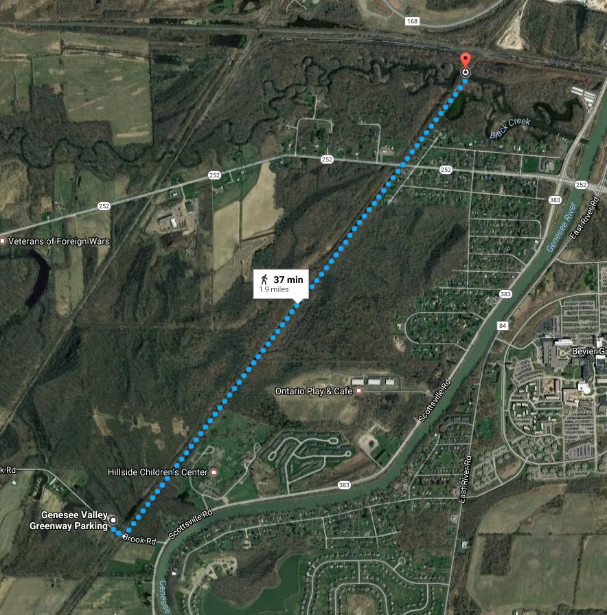 Today’s hike is an easy, flat trail with cinder surface, crossing an historic double-arched Genesee Valley Canal (GVC) culvert.
Meet at the Brook Rd Genesee Valley Greenway (GVG) Parking area. Total distance out and back is 3.7 miles.
For more information, check the Friends of the Genesee Valley Greenway (FOGVG) website, their Passport page, and the complete 2017 GVG Passport Series.
– – – Additionally, the Genesee Valley Greenway State Park (GVGSP) Facebook page usually lists the upcoming GVGSP events, and the FOGVG Facebook page also lists numerous GVG events in our area albeit a greater proportion of events listed on this page may at times be in the “Southern Tier” portion of the GVG as planned by a group of hikers known as the Southern Tier Greenway Hiking Group (STGH or STGHG) who welcomes all to hike with them.
– – – We also have a short history of the Greenway.
(subnote: The historic double-arched Genesee Valley Canal culvert (aqueduct) is best viewed for picturesque value from points other than on the GVG itself. As attested to by on-site GVG signage, the culvert/aqueduct, later turned viaduct for the railroad and subsequently the GVG, conducted the GVC over Black Creek. A great photographic vantage point is offered while on Black Creek in a kayak/canoe/boat. At low water levels you may be able to paddle Black Creek under the GVG to view both sides of the historic culvert , but at high water levels … well, not so.)
So, you’ve been itching to get on your bike this Spring with impetus of a group bike outing of some kind. Well, here is an opportunity to do just that … on the Genesee Valley Greenway (GVG) from Avon to York Landing (round trip) on Saturday May 20th, 2017 at 10:00AM. Approximately a 17 mile round trip easy paced bike ride, and all trail mileage covered is in the nw corner of Livingston County. Meet location is at the Erie-Attica Trail (EAT) trailhead in Avon, accessed by Farmers Road off Rts 5&20 just east of the Genesee River.
– – – A digression – – Speaking of itching, this Hike Planner has had impetus to utilize the section of the GVG shortly north of Fowlerville Rd (and south of US Rt 20), said section has a short duration of trail topped with thick stone dust (mostly fine stone sans dust), for a ST hike since early Spring 2016 just following reconstruction of said section of trail which had been necessitated as result of a huge washout area. The thick stone dust topper (as determined during a potential preview hike in April 2016), provided wonderful cushioning upon a hikers joints, albeit bike/stroller/wheelchair wheels found much friction/consternation due to sinking in the freshly laid thick topper surface.
Due to complaints of wheeled trail users, later in 2016 the topper surface was rolled by a heavy duty roller to make for some compaction factor, and the surface is said now to be kinder to the aforementioned narrow wheeled vehicles (and probably offers less of an exuberant opportunity for a hiker’s joints). If there is a lesson here, perhaps it is that not all opportunities are lasting, some have but a small window of opportunity. Still, a future ST hike planned to utilize this section of the GVG may offer multiple unique opportunities including this now somewhat tamed section of thick stone dust topper.
Anyway, you’ll get to see this short section and so much more of the GVG via your bike on this traverse much more quickly than while on a hike. – – –
(A further digression, …for the curious, … utilization of the aforementioned section of trail south of US Rt 20 was in consideration for the 4/24/2016 ST hike, but ultimately was scrapped from the fledgling Hike Plan due to what would have been a controverted driving route to reach the GVG trailhead parking lot on US Rt 20, all thanks to road reconstruction on US Rt 20 just east of the GVG trailhead. -Now you know – substantially trials and tribulations that weighed in nixing this unique section of trail south of US Rt 20 for the 4/24 ST hike, … instead all hiking groups headed north from Avon.) – – – End of digressions. – – –
GETTING THERE:
From just inside Avon’s western town limits, to reach the Erie-Attica Trail parking lot & trailhead follow Farmers Rd to the end where you’ll find both the parking lot & the trailhead. – – – Seem familiar? Well, ST has in the past (10/18/2015 hike) held a hike utilizing exactly this trailhead and parking lot, as well as parts of the connecting GVG, so yes, it may seem familiar. And an April 24th 2016 ST hike also utilized the GVG in this area.
Detailed Directions From Springwater: Take Rt 15A North. In Lima, turn left on US Rt 20 (concurrent NY Rt 5, thus known as Rts 5&20). Follow Rts 5&20 for 7.6 miles (you will cross over I-390, pass through the hamlet of East Avon and the Village of Avon. After the traffic circle in the village, continue on Rts 5&20 for 0.8mi and turn right on Farmers Rd. The parking area is on the right, just after you pass under the flyover for the former RR truss bridge (now the Erie-Attica Trail truss bridge).
Further Event Details for this May 20th biking event are listed on the FOGVG Facebook page.
GVG Passport Booklet: This bike ride will cover a stretch of trail where you’ll be able to avail yourself of making a rubbing in the Wegman’s Passport to Family Wellness – GVG passport booklet. For those unfamiliar – – – Wegmans – “Passport to Family Wellness Program” series booklet for the Genesee Valley Greenway is a passport compilation of 14 separate hikes on the GVG, each hike route having a “rubbing post” for trail users to produce a “rubbing” in their passport booklet with purpose of documenting that a trail user has completed the respective hike. Passport booklets filled-in with rubbings can be turned in at a Wegmans retail store for redemption of coupons for Wegmans brand products and entry for a prize drawing. So, remember to bring your GVG passport booklet on this bike ride.
(Event post initially published on 5/7/2017, updated 5/17/2017.)
Genesee Valley Greenway State Park (GVGSP) Passport Hike Series–Brook Road to Morgan Road–Wegmans Hike #3
Saturday, June 10, 2017 at 10:00 AM
Brookdale Preserve, on Brook Road, Scottsville, NY
The GPS Coordinates: N43 04.577 W77 42.550
Meet at the Brook Rd Genesee Valley Greenway (GVG) Parking area.
The hike will be going southward from the Brook Road parking lot along the eastern edge of Brookdale Preserve. We will see remnants of the Genesee Valley Canal and the well preserved Lock #2.
The hike leader is Elijah Kruger from the educational staff of Letchworth State Park. The hike distance is 4.3 miles round trip. The Genesee Valley Greenway State Park is hosting this hike. There is no charge to attend this hike. Therefore, please consider joining us.
For more information, check the Friends of the Genesee Valley Greenway (FOGVG) website, their Passport page, and the complete 2017 GVG Passport Series.
– – – Additionally, the Genesee Valley Greenway State Park (GVGSP) Facebook page usually lists the upcoming GVGSP events, and the FOGVG Facebook page also lists numerous GVG events in our area albeit a greater proportion of events listed on this page may at times be in the “Southern Tier” portion of the GVG as planned by a group of hikers known as the Southern Tier Greenway Hiking Group (STGH or STGHG) who welcomes all to hike with them.
– – – We also have a short history of the Greenway.
Looking for brochure.or mailing list so I can receive it in the mail.
Nothing opens up for mailing list.
There’s all kinds of very bizarre ads and post for viagra and other drugs above on calender page.
Please let me know if there’s a brochure available