
Hikes led by Springwater Trails are generally held on Sunday afternoons and appear in this calendar in green.
| Sun | Mon | Tue | Wed | Thu | Fri | Sat |
|---|---|---|---|---|---|---|
| Hike at Mt. Morris Dam, Mt Morris 2:00 pm Hike at Mt. Morris Dam, Mt Morris @ Mt Morris Dam hike Mar 2 @ 2:00 pm – 4:00 pm 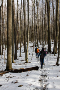 This Sunday, we will hike the Finger Lakes Trail (FLT) starting at the Mt. Morris Dam and Visitors Center Parking Lot. We expect to enjoy the height of winter as we follow the east rim of the Letch worth … Continue reading | ||||||
| Winter Hike, Ski or Snowshoe – All Western Evergreen Farm, Springwater 2:00 pm Winter Hike, Ski or Snowshoe – All Western Evergreen Farm, Springwater @ Liberty Pole Road Mar 9 @ 2:00 pm – 4:00 pm 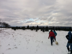 You are invited to hike, ski or snowshoe on a very special private property near the Northwestern corner of Springwater on the 248 acre All Western Evergreen Nursery & Christmas Tree Farm! Note, this hike was rescheduled from 2/16/25 date which … Continue reading | ||||||
| Hike at Sandy Bottom Park, Honeoye 2:00 pm Hike at Sandy Bottom Park, Honeoye Mar 16 @ 2:00 pm – 4:00 pm 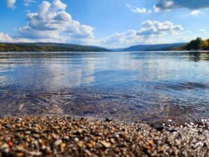 Our hike this Sunday, March 16th will be at Sandy Bottom Nature Trail starting from Main Street across the street from Birdhouse Brewery (8716 Main Street Honeoye, NY 14471). This is where we will park and gather. The hike will … Continue reading | ||||||
| Canadice Westside Trail Hike, Canadice 2:00 pm Canadice Westside Trail Hike, Canadice Mar 23 @ 2:00 pm – 4:00 pm  This week’s hike will be on Canadice Lake Trail! This is an easy, 1.8-mile each way hike along the shore of the lake; the trail is level and well-maintained and the lake views are lovely. For most hikers it will … Continue reading | ||||||
| Hike at Affolter’s Family Homestead, Hemlock 2:00 pm Hike at Affolter’s Family Homestead, Hemlock Mar 30 @ 2:00 pm – 4:00 pm 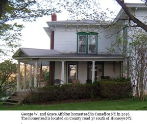 You are invited to hike, on a very special private property at the Affolter family homestead (circa 1900), on Sunday March 30th! The farm, which originally spanned over 360 acres, has been in the Affolter family for over three generations. … Continue reading |
Naturalists will head out on Bear Cub to the Chalet Trail. Chalet is an old road that once led to a large chalet and cabins which housed a camp at one time. Two of the old red cabins are still standing. This group will cross a few bridges, pass a pond, and make their way to the great scenic view Overlook. Then it’s a half mile hike up Overlook Rd to return to the starting point. Total mileage about 2.8 miles.
Social: Following the hike please join us for some food/drink at the Birdhouse Brewing Company, 8716 Main Street, Honeoye .
We will explore the Red and Green Trails. Please wear Blaze Orange if you have it or another bright color.
Address: 6280 Gulick Road, Naples Entrance/Parking is North of Cumming Nature Center
From Finger Lakes Land Trust web site: (During the full hunting season, from October 1 – December 19, the majority of the preserve and hiking trails will remain open to the public, including the area of the preserve lying west of the cabin and to the overlook (at the yellow/blue trail junction, west of the orange/yellow trail junction). The yellow and blue trails accessed from Wesley Road will be closed to the public to allow for bow hunting in a section of the preserve.
Map of Wesley Hill Preserve – https://www.fllt.org/wp-content/uploads/2015/02/Preserve-Brochure-Wesley-3.pdf
The Social will be a potluck/dish to pass at Kelly’s home, 36 University Avenue, Atlanta. See directions below. Bring your our own beverage and a favorite dish to share, or contribute $5 to our social fund.
Directions to Wesley Hill Preserve, Gulick Road parking area:
From Honeoye: take route 20A east through Honeoye to East Lake Road (CR 33). Turn right onto East Lake Road. (If coming from Bristol or points east, it’s a left onto East Lake Road). Take the first left, staying on CR 33, then the first right onto Pinewood Hill which becomes Gulick Road. Travel about 5 miles to Wesley Hill Parking Area on the right side. Parking lot can fit about 16 vehicles; any late comers can park on the side of the road.
From Springwater: Head north on Rte. 15A toward Hemlock. Just before Hemlock, turn right on Rte. 20A. Follow Rt 20A to Honeoye and then follow the directions above.
From Naples: From the southern end of Naples, head west on Co Rd 36. Follow Co Rd 36 for 1.2 miles to the first right turn on Gulick Rd. Follow Gulick for about 7 miles, past Cumming Nature Center. The parking area is on the left.
Directions to Social: Leaving the parking lot on Gulick Rd, head South to Hunt Hollow Rd/County Rt 36. Turn Right onto Hunt Hollow Rd. Take a short distance to Maxfield Rd and turn left. Follow Maxfield to Eelpot Rd and turn Right. Follow Eelpot to Route 21 and turn Right. Follow 21 as if going to Wayland, making the right turn in N Cohocton at Mikey’s Mini Mart, then make your first left onto University Ave. The house is the 2nd home on the right past the Fire House. Please park on the street or in the left side yard via the dirt drive. Leave the gravel drive open as I’ll have everyone enter through the back door/mud room.
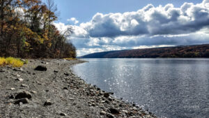
The water in Hemlock Lake is very low at the moment and a wide swathe of beach is exposed. We will take advantage of the unusual conditions to walk as much of beach as we can on this Sunday hike. The beach is generally 12-15 feet wide and varies between stony and rough stone chips. It will be a slow and careful walk but there’s plenty to see along the way and the lake and the late autumn woods on the opposite shore are very scenic. Wildflowers are scarce in November, but there are tiny pink and yellow flowers growing in the shelter of the stones.
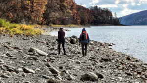
Meet at 1:45 at the north boat launch, south of the eastern edge of Hemlock Lake State Park. There’s a generous parking lot there and easy access down to the exposed beach. This is necessarily an out-and-back hike, so all groups will walk south together and anyone can turn around at any time. The beach follows the path of Rob’s Trail just a few feet away in the woods, and there are lots of places where walkers can switch between the beach and Rob’s Trail. All groups will walk south together and the naturalists and tourists can turn around whenever they feels it’s the right time.

The social will be a dish-to-pass picnic at Jane Affolter’s farmhouse at 5422 County Road 37
Directions: from Springwater: Head north on NY-15A. At the end of Hemlock Lake, turn left on Rix Hill Road. Almost immediately turn left on to Old East Lake Road, go past the Rochester City water treatment plant and continue on Old East Lake Road until you come to the boat launch parking lot.
Directions: from Canandaigua, Honeoye and points east: From Honeoye, continue west on Main Street (Route 21A) to Route 15A in Hemlock. Make a left, go a half mile, and take a right on Rix Hill Road. Almost immediately turn left on to Old East Lake Road, go past the Rochester City water treatment plant and continue on Old East Lake Road until you come to the boat launch parking lot.
Directions from north and west: Take Route 390 south to Exit 9 (Lakeville-Livonia). Go south on Route 15 into Livonia, the southeast on 20 A. Make a right after 3.9 miles on County Road 56 (Federal Road), then a left on Adams Road after .6 miles. Take the second right on Blank Road. In a mile, fork left at Rix Hill Road and almost immediately turn left on to Old East Lake Road, go past the Rochester City water treatment plant and continue on Old East Lake Road until you come to the boat launch parking lot.
Join us on Sunday Nov 19th for a Fairy decent hike. Everyone will meet at the Nature Center parking area at 27 Pond Road, Mendon at 1:45 for a 2PM start.
Naturalists will explore the Nature Trail and parts of Birdsong and Quaker Pond Trails. Birdsong and the Nature Trails are noted for feeding the chickadees from your palm so bring some birdseed and give it a try. This hike is a loop with a length of about 1.5miles with the option to add another 1/4mile loop towards the end.
Social afterwards at Flaherty’s Restaurant, 60 W. Main Street, Honeoye Falls.
Directions to Nature Center:
From Springwater: Head north on 15A for 21.6 miles through Hemlock and Lima. Take a right at the exit to Honeoye Falls. Stay on W Main St into the village where you will join NY 65 (1.9 mi). Continue straight onto NY 65 for 4.4 mi. (At 2 miles, you will go around a traffic circle. Stay on NY 65.) Turn right onto Pond Rd at the first park entrance. The Nature Center is just inside the entrance, on the right.
From Honeoye, take US 20A west and head north on CR 37 for 8.2 miles to W Bloomfield. Continue straight on NY 65 for about 3 miles, and make a right on Quaker Meeting House Road just before you come into Honeoye Falls. When Quaker Meeting House Road ends at Route 251 (Rush-Mendon Road), go left and then right on Route 65/Clover Street. The Pond Road entrance to the park is about 2 miles to the north, on the right. The Nature Center is just inside the entrance, on the right.
From Rochester: Exit I590 at Monroe Ave toward Pittsford. Turn right (south) onto NY 65 (Clover St). In about 6.7 you will come to the Canfield Road entrance to the park – this is not the one you want. Continue another 1.5 miles, then turn left onto Pond Rd, the second entrance into the park. The Nature Center is just inside the entrance, on the right.
Directions to Flaherty’s for Social: From Nature Center parking lot, go left to Clover Street (Route 65) and then left toward Honeoye Falls. Proceed about 5.5 miles to Honeoye Falls and through the center of the village. Flaherty’s will be on your left at #60 W. Main Street, which is Route 65.
Powder Mills Park, off Route 96 in the Town of Perinton, is one of Monroe County’s outstanding hunting-free hiking parks, with a nice group of wooded glacial ridges and lowlands on a 380 acre property with a fish hatchery and a ski hill. It has been a county park since 1930, after an interesting history as a gunpowder factory, and it’s a fine spot to work off some of those holiday desserts.
Meet at the Rand Lodge Parking Lot on Park Road at 1:45 for a 2 PM start. Warm layers, hiking poles and good boots are advised. The Climbers will follow a winding course (low ridges and lowlands) of about 4 miles through the park, both north and south of Woolston Road. The Tourist/Naturalist group will follow along with the Climbers for about 1.5 miles, then split off on Trillium Trail for a detour to the Fish Hatchery and back to the start, for a total of about 2.25 miles.
Please join us afterwards for our optional post-hike social at Panera Bread, 7651 Route 96, Victor.
Directions:
From Springwater: Head north on 15A and make a right on Kellogg Road to County Road 37. Continue on CR37 to West Bloomfield and continue straight when it becomes Route 65 (West Bloomfield Road). Continue past Route 251, and make a right on Smith Road. Continue past Route 64 and make a left on Mile Square Road, which becomes East Street. In 2.6 miles make a right on Park Road. The Rand Lodge parking area will be on your right.
Via 490: From Interstate 490 – take the Bushnell’s Basin exit. Go left on Route 96, pass the Garnsey Road light, and take a right on Park Road. Go past the Fish Hatchery and Corduroy Road, then take the first left into the Rand Lodge parking lot.
Post Hike Social: will be at Panera Bread, 7651 Route 96, Victor. Directions to Social: Go right from Rand Lodge lot onto Park Road, take a right at the end on Route 96. Follow Route 96 for 2.5 miles, past Eastview Mall. Panera Bread will be on your right, just before the light for Kohl’s and Walmart. If you miss the Panera driveway you can go right toward Hampton Inn at the light and then back across the parking lot to Panera Bread.
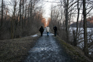
Continuing with our hunting-free hike series, please join us on December 3 for a walk, or a bike ride if conditions permit, on the Erie Canal Trail starting at Lock 32 Canal State Park, at 2759 Clover Street in Pittsford (just north of Jefferson Road-Clover intersection and across the canal). Meet at 1:45 for a 2PM start at the Lock 32 parking area. The canal trail is flat and paved in both directions. Going east will take you toward downtown Pittsford Village in about 1.25 miles. Going west will take you through a more wooded residential neighborhood, where you will meet the 490 overpass in about 3 miles, or ride all the way to Genesee Valley Park and the river in about 5 miles. Groups will decide on their routes at the start.
Directions: From the South (Springwater):
Travel north on 15A and make a right on Kellogg Road to County Road 37. Continue north on CR37 to West Bloomfield. Continue straight and it becomes route 65 (West Bloomfield Road). Just past West Bloomfield, bear to the left as the road makes a sharp curve to the left, follow signs for Rt. 65. You will continue on Rt. 65 until you reach the destination. You will cross over the canal and see Lock 32 on your left. Go past the lock and there will be a sign for the County Park. Make a left into the parking lot where we will all meet.
From the West – Travel east on Jefferson Rd. Make a left on Clover St. (Rt. 65). You will cross over the canal and see Lock 32 on your left. Go past the lock and there will be a sign for the County Park, make a left into the parking lot where we will all meet.
From the East – Travel west on Jefferson Rd. Make a right on Clover St. (Rt. 65). You will cross over the canal and see Lock 32 on your left. Go past the lock and there will be a sign for the County Park, make a left into the parking lot where we will all meet.
The Social after the hike will be held at The Cheesecake Factory, 3349 Monroe Ave, Pittsford.
From the canal parking lot make a left onto Clover St. (Rt. 65). Continue to the Rt. 31 intersection where you will make a sharp right onto Rt. 31 (Monroe Ave.) The Cheesecake Factory will be on the right at the front of the Plaza.
This Sundays hike will be at Sandy Bottom Nature Trail starting at the entrance off Main Street in the Village of Honeoye. All hikers will Meet at 1:45 PM.
There is parking across the street from the trail entrance. Sandy Bottom Trail is about 3 miles total . The climbers may wish to retrace their hike to make this a 2 hour hike.
Naturalists and tourists can walk at their own pace.
After Hike Social: After the hike those who wish can go to the “Bird House ” for dinner. this is located in the brown building across the street from the sandy Bottom Main Street entrance where the hike started.
Directions:
From Springwater: Head north to Route 20A in Hemlock. Turn east on Route 20A. , Drive about 5 miles to Honeoye Main Street. Sandy bottom Trail is on the right (blue sign). Parking is available across the street.
From Naples: Go north on County Road 36, Continue on County Road 36 to Honeoye. Turn right onto State route 20A(Main Street Honeoye). Sandy Bottom Trail is on the right (blue sign). Parking is across the the road.
From the east (Bristol, Canandaigua, etc): Take Rte 64 south to Rte 20A, make right onto 20A, Continue on 20A to Honeoye. Sand Bottom Nature Trail is on your left off Main Street.(blue sign) . parking across the street.
From the west (Hemlock, Livonia, etc): Take Rte 15A to Route 20A, make left onto 20A, Continue on 20A.. Drive about 5 miles to Honeoye Main Street. Sandy bottom Trail is on the right (blue sign). Parking is available across the street.
Join us for the final hike of the year for Springwater Trails. This hike will be on private property on Schribner Rd in Springwater.
NOTE: Bow and Muzzel loading seasons are open on the day of the hike, but at the time of the hike, no hunters will be on most of the private land hosting our hike.
We will have two or three hikes available, depending on demand. All hikes will start at the Hopkins’ home, located on the south west side of Schribner Rd just before (if you are coming from Tabors Corner) the intersection with Giles Rd.
All hikers will leave from the front of the house and will follow the trail by the woodshed, and along the creek, by the A-Frame to the blueberries.
At this point, the climbers and tourists will turn left down to the stream and then up to the hardwood forest. The climbers will take several switchbacks to get to the potato fields. Continuing up the hill, we will enjoy the views of the fields and follow the edge of the forest around to an entrance to the forest on the west side. From there we will head north to cross Giles Rd where we will stop briefly to investigate a cemetery from the 1880s. The trail continues north along a small creek which eventually flows into the Chesapeake Bay. From there, we will make our way back to the house for some more socializing.
Meanwhile, the tourists take a more direct route to the west side exit to the potato field. A quick U-turn will take us to the north trail, past the cemetery, around the valley and back to the house.
When the Naturalists depart from the climbers, they will continue north west along pine forests planted in the 30s and 50s and through some older natural white pines. We will pass the multicolored barn to follow a loop through the woods. Unless a one-horse sleigh picks us up, we will continue back south and cross the “bumpy” field to the house.
Following the hikes, all hikers are invited to join us for a seasonal social at the house. We will have a ham to share. Please bring a side dish or appetizer or dessert and your favorite beverage. Or make a small donation to the social fund.
Preview: Rather than a hike on New Years Eve, Springwater Trails is again leading a hike on New Years Day as part of the state-wide First Day Hikes program. Please join us at 2:00 at the north end of Canadice Lake. You will meet many hikers new to Springwater Trails. Or if you are more adventurous, there are 8 hikes on the Greenway, and one near Alfred at Phillips Creek State Forest. Check out the map. Its a great way to start the new year.
These directions are being provided because Schribner and Giles are seasonal roads at the north west ends. If you use your GPS, please be sure that you are coming up Schribner Rd from Tabors Corners Rd. Enter Tabors Corners and Schribner Rd, Wayland NY. Just to make sure you have good directions for the winter, check that the directions do not include Strutt St or Quanz Rd or Giles Rd. And whatever the weather is like, do not turn onto Schribner Rd from Strutt St (you will regret it!).
When you get onto Schribner Rd, continue for 1 mile. The driveway is on the left one mile up Schribner Rd and about 10 feet before the intersection with Giles Rd. There is room for a few cars in the driveway, or turn around at the intersection and park on the the road. You may also park on the second driveway on the far side of the intersection, although, if you pull up the driveway, others may park behind you!
From Springwater: Head north on Rt 15A from the light in Springwater. Take the first right on Wheaton Hill Rd (Co Rd 16). Turn right on Wetmore Rd at the stop sign at the top of the hill. At the end of Wetmore, bear right on Tabors Corners Rd. After 3.5 miles turn right on Schribner Rd. Follow the directions above in green.
From Wayland: From Rt 15, head east on Rt 21 toward North Cohocton for 3 miles. Turn left on Tabors Corners Rd (Steuben Co Rd 37). After 2 miles, turn left on Schribner Rd (the second left). Follow the directions above in green.
From Honeoye: From Rt 20A, head south on Ontario Co Rd 37. At Canadice, continue straight ahead on Canadice Hill Rd as Co Rd 37 turns right. When Ross Rd bears to the right, take the right. This avoids the potholes in the dirt road straight ahead. In 2.7 miles, turn left on Tibbles Rd (the first left road on Ross Rd. In 1.1 miles turn right onto Wetmore Rd. Stay on Wetmore up over the hill to the end (2.2 miles). Bear right on Tabors Corners Rd. Turn right at 3.5 miles onto Scribner Rd. Follow the directions above in green.
From the East Lake Rd in Honeoye or From Naples: Rather than traveling north to reach 20A or Co Rd 37, hikers from east of Honeoye Lake may go south to Ontario Co Rd 36 and follow Co Rd 36 to Naples. Turn right on Rt 21 south. Turn right to stay on Rt 21 for 4.5 miles to N Cohocton. Turn right to stay on Rt 21 towards Wayland. After 3.8 miles turn right on Tabors Corners Rd (Steuben Co Rd 37). After 2 miles, turn left on Schribner Rd (the second left). Follow the directions above in green.
Looking for brochure.or mailing list so I can receive it in the mail.
Nothing opens up for mailing list.
There’s all kinds of very bizarre ads and post for viagra and other drugs above on calender page.
Please let me know if there’s a brochure available