
Hikes led by Springwater Trails are generally held on Sunday afternoons and appear in this calendar in green.
An educational Hike with Springwater Trails and Victor Hiking Trails with impetus and designed to identify and view BLUEBIRDS, … and more, held at MaryFrances Bluebird Haven (MFBBH).
Trail conditions update, gained from 5/6/2017 Saturday’s preview hike: very wet, rubber boots suggested. Bluebirds were observed. For this hike & potluck after-hike social event, perhaps we can agree on “cloudy with a chance of meatballs.” The hike is offered rain or shine.
Starting at 2:00 p.m. on Sunday, May 7th, 2017 will be a joint hike of Springwater Trails (ST) and Victor Hiking Trails (VHT). For ST this is our regular Sunday weekly hike. For VHT this is a special hike outside of the monthly guided hike held on the 2nd Saturday of each month.
This is a special educational hike event at MaryFrances Bluebird Haven (MFBBH), a Town of Victor park, located at 235 County Rd 9 in Victor, NY. – – MFBBH entrance driveway, leading to the parking lot, is located on the east side of County Rd 9 (aka Victor-Egypt Rd) just south of intersect with Valentown Rd (which intersects from the west).
HIKING GROUPS, TRAIL ROUTING, (and map hyperlinks):
The hike, will have two separate sub-groups. Routing will be be slow and easy on mostly flat terrain for the Naturalists/birdwatchers group covering ~1 mile (the whole of the perimeter trail) within the MFBBH park, Gene as Hike Leader. The second routing will be fast paced for the Climbers/Tourists group covering ~3 miles within MFBBH park & on adjacent Monkey Run Trails, Dave as Hike Leader. (Climbers/Tourists routing will include MFBBH perimeter trail (~1mile) & MR three loop trails ~2miles of woodland walk, all mostly flat terrain.) MFBBH map // Monkey Run Trails map
KNOWLEDGE & EQUIPMENT:
We will have multiple hike leaders who are knowledgeable about birds, so bring your binoculars and camera (and telephoto lens if you have one). Also, wear good hiking boots as there may be some muddy spots. Possiblity that TDs (Traction Devices) may be helpful, but certainly not required. Hats with a visor and sunglasses may also be useful.
– Some ST hikers seized the opportunity to attend a presentation program “All About Bluebirds” held at the Geneseo Riviera Theater on Friday March 10th, 2017, one impetus that spurred this 5/7/2017 hike. Tickets for “All About Bluebirds” presentation were essentially “sold out” well prior to show day. Those ST hikers who attended will be looking to put newfound knowledge to use on this 5/7/2017 Bluebird hike. (Some other ST hikers were tending to matters as result of the 80+MPH windstorm of Wednesday 3/8/3017 on that Friday.) –
Hikers will have opportunity to learn about the impetus and history of MaryFrances Bluebird Haven.
Please note: Dogs are NOT allowed on this hike. Alcohol, smoking, and weapons are not allowed per park regulations. Oh, … and leave your saddle and mount at home, because horses are not allowed in this park, thus you’ll need to choose another mode of transportation to this hike.
AFTER-HIKE SOCIAL:
There will be an optional after-hike social dinner at the Butler Cottage located in MFBBH park beginning at 4:00 pm ; bring a dish to pass or make a donation (suggested $5) to the social fund to help defray expenses, and bring your beverage of choice (no alcohol please), if you would like to meet your fellow hikers. You may bring your own tableware if you’d like, albeit, disposable plates, plastic utensils, etc will be on hand as at most ST potluck socials.
Butler Cottage is a totally enclosed edifice with electricity / lighting / indoor plumbing / full facilities: restroom, full kitchen (counters & cabinets, stove/oven, refrigerator, microwave, and yes the “kitchen sink” too complete with running water), etc. The main area with tables and chairs accommodates 45 people. So, there is availability for heating up dishes best served warm, refrigeration, etc. Some hikers may wish to avail themselves prior to the start of the hike.
PARKING:
MFBBH parking lot will accommodate ~ 20 cars. Additional parking can be had along the entrance driveway, with judiciousness & thoughtfulness in mind.
DIRECTIONS:
From Springwater (and select other points south of Victor):
~45+ minutes drive from Springwater hamlet’s 4 corners, travel NY Rt 15A northbound (to just s of hamlet of Hemlock) ; turn right/eastbound onto NY Rt 20A (eventually passing through the hamlet of Honeoye, and continuing on NY Rt 20A northeasterly to just south of the hamlet of Bristol) ; turn left/northbound onto Co Rd 2 aka Oakmount Rd, pass through the hamlet of Bristol and continue straight on what will eventually become Oakmount Ave, crossing NY Rt 20 <USE FOREMOST CAUTION at this crossing!> to jct with Main St in Village of Bloomfield ; turn right/eastbound on Main St ; turn left/northbound onto NY Rt 444 (aka Elm St which becomes Victor Holcomb Rd which becomes Maple Ave) to jct with NY RT 96 aka East Main St in the Village of Victor ; turn right/eastbound onto NY Rt 96 aka East Main St ; turn left/northbound onto Church St ; Church St becomes Victor-Egypt Rd aka Co Rd 9 ; travel to 235 Victor-Egypt Rd where Mary Frances Bluebird Haven driveway is located ; turn right onto the entrance driveway to the MFBBH parking lot.
From Rochester area: (center city, areas directly contiguous east, as well as north and west Monroe County areas) ~ a bit under 30 minutes drive from Rochester get on I-490 eastbound expressway and travel to exit 28 (for NY Rt 96 southbound, in Perinton) ; from the exit 28 ramp turn left/southbound onto NY Rt 96 south ; from NY Rt 96 south turn left/eastbound onto High St (which is opposite Eastview Mall’s southern-most entrance drive) ; from High St turn left/northeastbound onto Valentown Rd ; <take note of the Valentown Museum as you pass it on the left side of the roadway> drive Valentown Rd (to road’s end) the jct with Victor-Egypt Rd aka Co Rd 9 ; turn right/southbound onto Victor-Egypt Rd, and then a quick left/eastbound into the driveway for MFBBH.
[Alternatively, I-490 expressway to exit 26 for NY Rt 31 eastbound, to Victor Rd aka Co Rd 52 (which becomes Victor-Egypt Rd aka Co Rd 9) ; turn right onto Victor Rd and travel to 235 Victor-Egypt Rd driveway for MFBBH ; turn left/eastbound into the driveway.]
CARPOOLING:
Carpooling in name of efficiency is encouraged due to distance from Springwater and also in light that this is a joint hike with VHT.
Named sequential carpool points (unsupervised), corresponding with directions to the hike (as written above) are: (1) <gather 12:40PM, leave at 12:50PM> Springwater Town Hall at 8022 S. Main St (aka NY Rt 15), in Springwater ; (2) <gather 1:00PM, leave at 1:10PM> Hemlock Lake Park parking lot, located at the northern end of Hemlock Lake and accessed via Rix Hill Rd immediately off NY Rt 15A (and a bit south of the jct with NY Rt 20A) ; (3) <gather at 1:15PM, leave at 1:25PM> in the hamlet of Honeoye on south side of Main St (aka Rt 20A) in the Honeoye Commons Plaza (~ 8567 Main St) parking lot of CVS/Subway/etc, optimally you wanna park closest to Main St. The entrance drive for Honeoye Commons Plaza is the next entrance drive past the entrance drive for Shurfine/Dollar General stores. (additional reference point: Honeoye Commons Plaza is ~ opposite Honeoye Central Schools).
Please note this sequential carpooling arrangement is set up so that those from further south will make a stop at each further north sequential carpool point, and potentially take on added passengers or reconfigure. There is an allowance of ~ 5 minutes from arrival to departure at each, to allow for loading, and not much fudge factor beyond that. Assuming all goes well, arrival at MFBBH for the hike is calculated to be ~ 1:55PM.
Additional information: can be gained from checking the VHT website, Facebook, Meetup or the VHT voice message line [phone: (585)- 234-8226], as well as checking the ST website for updates.
SPRINGTIME BIRDING:
An additional Article on “Birding” on the ST website, in anticipation of this Bluebird hike, for those who wish to learn a bit more about “Birding” in Springtime.
Subnote: (reference to a future hike)
Hikers may wish to take note of Valentown Rd (nearly opposite MFBBH entrance driveway), as a future ST hike will in part refer to historic “Valentown” which is situated at the western end of Valentown Rd & High St (in the Town of Victor), about two blocks away from present day Eastview Mall.
Hints: * Valentown was built in anticipation of a chartered railroad that was never built, the CNY&N RR (Central New York & Northern). This railroad was a one-time planned northern extension of the CNY&W RR (Central New York & Western), and was akin to the CNY&W. Come August 1, 1899, the CNY&N was consolidated with its parent company the CNY&W.
** (spoiler alert!) The CNY&W was a predecessor in lineage of the PS&N RR (Pittsburg, Shawmut & Northern), and August 2, 1899 the CNY&W was merged with a number of shortline railroads in Pennsylvania into the newly formed PS&N RR. Both the CNY&W and the PS&N in successive lineage routed high above Stony Brook Glen through what is present day Stony Brook State Park. Both respective sets of railroad high bridge abutments that remain in Stony Brook Glen were in this railroad lineage.
(credit to the book by Paul Pietrak “The Pittsburg, Shawmut and Northern Railroad Company” for some information cited herein.)
Annually, one of two big shindigs (of a hiking variety) that Victor Hiking Trails (VHT) sponsors, is National Trails Day (NTD) observed the first Saturday of June. In 2017, the 25th year for this event in Victor, the date is June 3rd and the starting location is at Ganondagan State Historic Site Visitor’s Center located at 7000 Boughton Hill Road (County Road 41) .
VHT is of course one of many hiking groups that plans some organized observance on NTD. Yep, that word “national” does in fact imply many groups across the USA observe or celebrate NTD in some manner. Now, before I describe more about NTD activities, you were wondering what the other big shindig that VHT has annually. Weren’t You? Answer: the second big shindig VHT does is the VHT “Challenge Hike” usually held in late September.
NTD in Victor with VHT is usually three serial hikes, with a break in between each of the three hikes for rest and refreshment. The first hike is a morning hike and the last hike finishes in the afternoon.
You can read about National Trails Day from 2017 in the the VHT newsletter The Pathfinder Spring 2017 edition (volume 22, issue 1, page 1). And of course, you can check the VHT website for updated details about the NTD hike for June 3rd, 2017.
If you’re Interested in past years NTD in Victor, …two most recent years are cited: National Trails Day from 2016 in the VHT newsletter The Pathfinder 2016 Spring edition , and from 2015 The Pathfinder Spring 2015 edition (volume 20, issue 1, page 6).
Chimney Bluffs State Park, on the Lake Ontario southern shoreline in eastern Wayne County, just east of Sodus Bay is indeed a unique place, and a quintessential hiking destination. This locale is distant enough from the Springwater and surrounds area such that not likely that Springwater Trails (ST) would plan a hike here … due to the travel distance. BUT, HOLD ON, … for those interested in hiking this destination with a group of like minded hikers, well, Victor Hiking Trails (VHT) is leading a hike here on Saturday, August 12, 2017. All hikers are welcome. And of course, ST & VHT as organizations share numerous common bonds.
This hike will be a good opportunity to see this unique scenic area, and the erosion caused by the high levels of Lake Ontario that have been the case in this 2017 Spring & Summer season. Chimney Bluffs area is constantly changing due to the geological make-up of this place. Erosion is a constant here, and increased erosion in 2017 hastens the change and loss at Chimney Bluffs. The uniqueness of the area is always under constant change, and erosion eventually claims the various geologic formations here, … sometimes sooner rather than later.
Any updated details can be gleaned from the Victor Hiking Trails website.
The published basics of the hike are:
-
VHT will meet in the parking area behind the Victor Town Hall (85 East Main St) at 9am, and carpool to the hike.
-
Hike Chimney Bluffs State Park
On Saturday, August 12th, Victor Hiking Trails will lead a hike at Chimney Bluffs State Park in Wayne County, NY.
There are 4 miles of moderate trails through woods, meadows and along the shore of Lake Ontario. Comfortable hiking boots are recommended. Please, no pets on this hike.
Bring insect repellent, sunscreen, something to drink and a snack.We may stop for lunch on the way home.
Meet in the rear parking lot of Victor Town Hall, 85 East Main Street, at 9:00 A.M. to carpool to the trailhead. Or meet at the park entrance located at 7700 Garner Road, Wolcott, NY 14590 at 10:15 A.M. There is a $5.00/per car fee.
Check the website www.victorhikingtrails.org, Facebook, Meetup or the voice message line (234-8226), for additional details.
Description
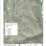
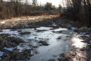
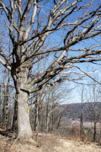
This preserve, maintained by the Finger Lakes Land Trust, is a perfect refuge during hunting season. In fact, our hikers will be performing a service to the land trust by patrolling the woods as they walk. Steege Hill is about 800 acres acquired in 2001 from an anonymous donor. The forest is regenerating after heavy logging in the 1970’s and contains many species of hardwoods. The 6 miles of trails are constructed largely on the old logging roads. On some of the steep slopes original hardwoods and conifers still remain. From its hilltop vantage point, there is a bird’s eye view of the Chemung River. Worth mentioning are two notable creatures that inhabit this woods. Timber Rattlesnakes have long been residents here, especially on the sunlit rocky outcroppings. They may be snugly out of sight this time of year. The nests of Allegheny Mound Ants are common sight, trailside and in clearings. Black bears like it here too.
Hike Groups
Lets hope the weather conditions are more favorable than last year’s wet and snowy visit to Steege Hill. All groups will depart together from the parking area, heading uphill for about 1/2 mile on a moderate pitch. There are 4 trail loops to explore.
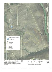
Naturalists will cruise around the Yellow Loop, about a 2 mile jaunt with a few small inclines and a pond. A volunteer leader is needed for this group.
Tourists will traverse the blue and orange trails, enjoying a variety of terrain with some moderate climbs, about 3.5miles. A volunteer leader will also be needed for this group.
Climbers will tackle the white and red trails which offer some up and down hill changes as well as a nice valley view. Distance is about 4.5 miles.
Hopefully all groups will arrive back at the starting point at approximately the same time.
Parking space at Steege Hill is limited. Carpooling is highly recommended. Meet in Springwater at the Town Hall on Route 15 at 12:45 as the drive is about 1 hour.
Directions take 390 south to I 86. Take exit 48 then follow Rt 352E for 1.5 miles. Turn right on South Corning Rd. for .7 miles. After crossing bridge across Chemung River, turn left on Steege Hill Rd. Follow for 1 mile. Preserve is on left.
After Hike Social will be at Tags Restaurant, 3037 Rt 252 in Big Flats. It is a very short drive from the hike. Good food. We have been there previously.
Annually, one of two big shindigs that Victor Hiking Trails (VHT) sponsors, is National Trails Day (NTD) observed each year on the first Saturday of June. In 2018 the date is June 2nd. VHT is of course one of many hiking groups that plans some organized observance on NTD. Yep, that word “national” does in fact imply many groups across the USA observe or celebrate NTD in some manner. Now, before I describe more about NTD activities that VHT hosts, you were wondering what the other big shindig that VHT has annually. Weren’t You? Answer: the second big shindig VHT does is the VHT “challenge hike” usually held sometime around late September.
NTD in Victor with VHT is usually three serial hikes, with a break in between each of the three hikes for rest and refreshment. The first hike is a morning hike and the last hike finishes in the afternoon.
Details for 2018 are: On Saturday, June 2nd, Victor Hiking Trails will host the 26th annual National Trails Day in Victor. Come to Finger Lakes Community College, Victor Campus, located at 200 Victor Heights Parkway, Victor, NY 14564, at 8:30 a.m. for a free continental breakfast. There will be three easy hikes beginning at 9:00 A.M., bottled water and snacks, a free pizza lunch with drinks and raffle prizes. Everyone who completes all three hikes will receive a free one-year membership to Victor Hiking Trails.
You can also read about National Trails Day 2018 in the the VHT newsletter The Pathfinder Spring 2018 edition (volume 23, issue 1, pages 2 & 7). A direct hyperlink to a VHT webpage about NTD 2018 is here. And of course, you can check the VHT website for updated details about VHT’s NTD hike for June 2nd, 2018.
Description
This preserve, maintained by the Finger Lakes Land Trust, is a perfect refuge during hunting season. In fact, out hikers will be performing a service to the land trust by patrolling the woods as they walk. No worries. In sixteen seasons, patrollers have never encountered a hunter.
Steege Hill Preserve is about 800 acres, acquired in 2001 from an anonymous donor. The forest is regenerating after heavy logging in the 1970’s and contains many species of hardwoods. Preserve steward, Bob Corneau, has maintained a network of over 6 miles of trails, constructed largely on the old logging roads. On some of the steep slopes original hardwoods and conifers remain. From its hilltop vantage point there is a bird’s eye view of the Chemung River.
Worth mentioning are two notable creatures that inhabit this forest. Timber Rattlesnakes have long been residents here, especially on the sunlit rocky outcroppings and in the shade of the forest. They may be snuggly out of sight at this time of year, but be cautious when stepping off the trail. The distinctive nests of Allegheny Mound Ants are a common sight at trailside and in clearings that the ants have fashioned for themselves by destroying shade plants to insure adequate sunlight and warmth for the colony. Black bears also have been sighted in the area recently. For more about this preserve go to http://fllt.org/preserves/steege-hill-preserve
Hiking Groups
All groups will depart together from the parking area on Steege Hill Road, heading uphill for about a half mile on a moderate pitch. There are four trail loops to explore.
Please note: The parking space is very limited. Carpooling is highly recommended. Meet at Springwater Town Hall on Route 15 at 12:45 as the drive is 1 hour.
Naturalists will cruise around the Yellow Loop, a gentle 2 mile jaunt with a few small inclines and a tranquil pond. We may be fortunate enough to have the steward of the refuge join this group. If not, a volunteer leader is needed.
Tourists will traverse the blue and orange trails, enjoying a variety of terrain with some moderate climbs, about 3.5 miles. A volunteer leader will be needed for this group.
Climbers will tackle the white and red trails which offer some up and downhill challenges, as well as a nice valley view. Distance is about 4.5 miles.
Hopefully all groups will arrive back at the starting point at approximately the same time.
Directions From Springwater, take I 390 south to I 86 E towards Corning. Follow I 86 east to exit 48, then follow Rt.352 east for 1.5 miles. Turn right on South Corning Rd. for .7 miles. After crossing bridge across the Chemung River, turn left on Steege Hill Rd.. Follow up hill for 1 mile. Preserve is on the left. Look for green and white sign.
Social will be at Tag’s Restaurant, 3037 Rt 252 in Big Flats, It is a very short drive from the hike. Good food. We have feasted there previously.
This hike is CANCELLED!!!!! The freezing rain across the region is too dangerous for both driving and walking!
Description
- This 800 acre preserve is a sanctuary for hikers during hunting season. It was acquired by the Finger Lakes Land Trust in 2001 with generous help from an anonymous donor. A stipulation of this gift was that the preserve would be patrolled during hunting seasons to protect against trespassers. Our hikers will contribute to this effort.
The hilltop preserve looks down upon the Chemung River between Corning and Elmira. At one time this area was nearly ruined by heavy logging, but the town of Big Flats stepped in to halt the destruction. The original forest has made an impressive recovery through natural regeneration of many tree species. On some of the steep slopes, original hardwoods and conifers remain.
Some forest residents are worth noting, although in December they are not likely to be visible. Timber rattlesnakes are long time residents here. Allegheny mound ants have also carved a niche. Black bears have been sighted in recent years. For additional information and history go to http://fllt.org/preserves/steege-hill-preserve
 Special Note: Although no hunters have been spotted here in all these years, please make yourself visible by wearing blaze orange. Conditions in December are unpredictable. It is advisable to bring hiking poles and traction devices for your boots.
The 6 miles of trails are largely old logging roads, well marked and maintained. All hikers will gather at the new and improved parking area on Steege Hill Rd, which has been recently repaved. It is still a small area so carpooling is encouraged. Meet at Springwater Town Hall on Rt. 15 at 12:45 to share a ride for the 1 hour drive to Big Flats.
Hiking Groups There is a moderate half mile climb from the parking area to the various trailheads.
Naturalists will enjoy meandering for about 2 miles along the yellow trail with its gentle slopes and a scenic pond. A hike leader will be needed for this group. Trail map will be provided.
Tourists will traverse the blue and orange loops for about 3.5 miles, enjoying a variety of terrain and some nice views. Uphills are moderate. A volunteer hike leader is needed for this group.
Climbers will tackle the red, white, and blue trails for a distance of about 4.5 miles with some up and downhill challenges.Directions Take 390 South to I86E.
Follow I 86 E to exit 48.
Take 353 E for 1.5 miles
Turn right on South Corning road and go .7 miles.
Cross Chemung River and turn left on Steege Hill Rd.
After 1 mile look for preserve sign on left.
After Hike Social will be at Tags Restaurant, 3037 Rt. 352 in Big Flats. We have enjoyed dinner here several times. See menu at http://www.tagsrestaurant.com
 Based on the latest COVID-19 New York State on PAUSE announcement, we expect to cancel Sunday’s trail maintenance. Please check back here tomorrow for our final decision.
The Annual Meeting scheduled for Sunday 22nd March is deferred to later in the year; instead, the walk this Sunday will be a maintenance hike of our section of the Bristol Hills Branch of the Finger Lakes Trail in Naples. Springwater Trails has signed up with the FLT to maintain this part of the trail. This segment passes through the West Hill Preserve off Seman Rd and then across private land to Mt Pleasant Street in Naples. The Twisted Branch Trail Run comes over this section later in the year; a couple of hundred runners will be pounding the hill and we want to be sure the trail is safe and fun to run.
We will walk this stretch of the BHB and cut away any brush and weeds that have overgrown the trail. The most useful tools for this are lopers and a small saw. It’s too early in the year to whack the long grass and we’ll note work that needs a chain saw for later treatment. Be sure to wear good work or gardening gloves. It’s a fairly long hike and steeply downhill at the Naples end of the walk.
We will meet at the entrance to the West Hill Preserve on Seman Road (42.66166, -77.396288). We will shuttle some cars down to the hike end in Naples (42.625950, -77.397304) before we start. The climbers will follow the trail down to the old cemetery in Naples. Naturalists follow the trail to the sign in box and then return to the cars on Seman Road.
Please note: Dogs are not allowed to hike on the Nature Conservancy property.
The Social
There won’t be an organized social in deference to the current fear of corona virus contagion. However, anyone who is brave enough and thirsty enough at the end of the hike will find us at Roots if they are still open.
Directions to the Hike Meeting Point:
From Springwater: Head south on NY 15 (for 5.2mi). At the light in Wayland turn left on NY 21N (for 6.7mi). In N Cohocton, turn left to stay on NY 21N (for 4.5mi). In Naples, turn left again to stay on NY 21N (for 1.8mi). On the north side of Naples, turn left on CR12 and head up the hill for 1.9 miles. Take the first left, Rhine St., to the 4 way intersection. Go left onto Seman Rd. Trailhead is about 1/2 mile, by a big sign on the left. Park along the road.
From Honeoye and Naples: Head south on CR 36 on the west side of Honeoye Lake (it’s 13.6 miles from NY 20A, and 1 mile from French Hill Road). Turn left onto Gulick Rd (for 2 mi), then right on Davis Rd (for 0.7mi). At the end of Davis, turn left on W Hollow Rd (CR 33) for 0.5mi, then right on Seman Rd. The Trailhead is about 1 mile, by a big sign on the right. Park along the road.

Looking for brochure.or mailing list so I can receive it in the mail.
Nothing opens up for mailing list.
There’s all kinds of very bizarre ads and post for viagra and other drugs above on calender page.
Please let me know if there’s a brochure available