
Hikes led by Springwater Trails are generally held on Sunday afternoons and appear in this calendar in green.
| Sun | Mon | Tue | Wed | Thu | Fri | Sat |
|---|---|---|---|---|---|---|
| Lehigh Valley Trail Hike or Bike in Rush, NY 2:00 pm Lehigh Valley Trail Hike or Bike in Rush, NY @ Stevens-Connor Lehigh Valley Lodge Apr 6 @ 2:00 pm – 4:00 pm Come join us for a leisurely hike or bike along the Lehigh Valley Trail on Sunday April 6th! With its flat even surface, the trail is a hidden gem for walking, hiking, jogging, biking. It is a vital link in … Continue reading | ||||||
| Ontario County Park at Gannett Hill Hike-Naples 2:00 pm Ontario County Park at Gannett Hill Hike-Naples @ Lookout Parking area Apr 13 @ 2:00 pm – 4:00 pm  This is one of our group’s favorite hikes! Ontario County Park at Gannett Hill is one of the highest points in Ontario County and located in the scenic Bristol Hills. At an elevation of 2,256 feet above sea level, you’ll … Continue reading | ||||||
| No Hike-Easter Break 2:00 pm No Hike-Easter Break Apr 20 @ 2:00 pm – 4:00 pm No hike has been scheduled for this date due to the Easter Holiday. Enjoy the break, spend time with loved ones and eat chocolate bunnies. This will give you something to burn off next week  | ||||||
| Hike Rob’s Trail – Hemlock Lake side 2:00 pm Hike Rob’s Trail – Hemlock Lake side Apr 27 @ 2:00 pm – 4:00 pm Join us on Sunday April 27th to hike the west side of Rob’s Trail, the DEC/Nature Conservancy property in the northeast corner of Hemlock Lake! Options are to hike out and back to the south along the trail from the … Continue reading |
Learn about the variety of trails in our region available for recreation and transportation. Investigate the policies, legislation, government agencies, non-profits and volunteers who created or supported these trails; and current efforts to expand this network of trails.
IMPORTANT Set your clocks ahead one hour tonight for Daylight Savings Time – Otherwise, you will miss the first hour of this hike! IMPORTANT
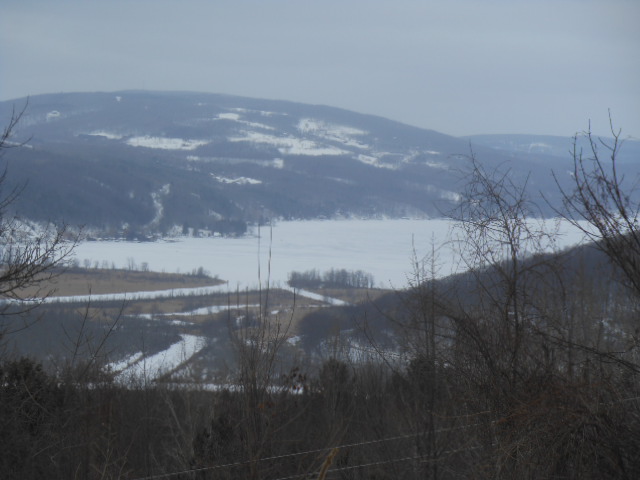
Views of south end of Canandaigua lake

traveling gnome

parking area on Rt. 245
Where will the traveling gnome take us hiking this week? We will explore the back roads and trails in the Conklin/Parrish Gully Hi-Tor area high above the south end of Canandaigua Lake. With beautiful views of the Canandaigua Inlet, West River, Bristol Mountain and surrounding hills and gullies, we will hike and/or snowshoe plowed or non plowed roads, as well as tread upon some of the nearby hi-tor trails if snow depth permits. Please note that no dogs will be allowed on this hike.

ice fishing on lakes

running out of wood
While many of us local folks are running out of wood, shoveling snow off our roofs, downhill skiing or ice fishing, dreaming about vacationing in Mexico, others are bravely snowshoeing in – degree weather to work off their winter sugar habits.

shoe shoeing on Lower Road, Naples

put on your lip balm
So put on your lip balm, dress warm, bring your snow shoes and join us for some winter fun. We will meet at 1:45 at the DEC parking lot on Rt. 245 to car pool up Parrish Hill Road to our starting point near Lower Road. From there we will break into at least 2 groups: Naturalists and Tourist/Climbers. Depending on snow conditions, Naturalists will hike the plowed roads of Lower Road and Parrish Hill Road. Tourists and Climbers will extend their hike on the non plowed extension of Lower Road, and plowed roads of Shay, DeWolf and Donley. Climbers may extended their snowshoeing into the nearby Bristol Branch of the Finger Lakes Trail System in the Hi-Tor area around Conklin Gully if snow depth conditions are acceptable.

lower road, naples
After hike social will take place at 3996 Lower Road at the corner of Parrish Hill Road and Lower Road. Park on Parrish Hill Road, social at first house on the left on Lower Road. Bring a dish to pass, your own drink and join some local neighbors that live in the hills high above Naples.
Directions:
From Wayland: Follow Rt 21 N through North Cohocton and on into Naples. On the north edge of Naples, turn right on Rt 245 N. Drive 1.7 miles to a DEC parking area on the right before Parrish Hill Rd on the right and Parish Rd on the left. We will park in the DEC parking area and car pool up to the start of the hike and to the social.
On Saturday, March 14th, Victor Hiking Trails will lead a hike on the trails at Harriet Hollister Spencer State Recreation Area. They have created additional trails, so plan on spending 2—3 hours on the trails. If the snow doesn’t all melt by then, bring your cross-country skis or snowshoes. Because of the high elevation and wonderfully groomed trails, the snow will likely be there until June. Bring a bag lunch and something to drink. Meet in the rear parking lot of Victor Town Hall, 85 East Main Street at 9:00 a.m. You can also meet at the park at 9:45 a.m.
(hint: if in reading this article as configured on the left side of the homepage, and in doing so you find something cut off at a margin to the side or bottom, merely “select” aka “click on” the article heading and the entirety of the article will fill the full available screen of your computer monitor.)
 HIKE DETAILS:
Owing to our colder than average temps in January & February this winter, and deeper than average (record-setting) snowpack accumulation, likely there will still be plenty of snow to enjoy for our Sunday “Ides of March” hike on March 15th, at the Springwater Center retreat facility which is located on the northwest hill above the hamlet of Springwater. (Statistically February 2015 has become our coldest mean temperature February on record.) Hike conditions for this Ides of March hike will be in definite contrast to our previous hike here on April 7, 2013 when winter snows were past.
Likely that this will be a hike to utilize footwear Traction Devices (TDs) or snowshoes. (maybe even skis?) Perhaps your preference. (The progressively higher sun angle and longer days, as well as now substantially increasing temperatures this week may make this a TD hike, rendering out possibility of snowshoes or skis.) We may have a conditions update prior to hike day, so check the head of this Hike Announcement on Saturday evening (or before) for a conditions update.
Two or three (or four) hiking subgroups will be formed, choose the one that best suits you. Differing hike lengths and pace will be offered. Wayne will lead the Climbers for the longest hike. Susan will lead either the Tourists &/or Naturalists hike route, each of which will traverse an abbreviated version of the Climbers route.
Trails consist of some open areas and many treed areas protected from wind on the over 200 acres of the Springwater Center grounds. The Ides of March are typically “not typical” from one year to the next, choose your attire based on weather conditions on hike day.
Also atypical, this hike provides for one of the hiking subgroups, by choosing, to be a silent hiking subgroup. Many activities at the Springwater Center meditation retreat facility involve minimal talking or no talking at times, as aiding to awareness of the here and now, to prevent distraction, allow for effective meditation, centering, and more. The silent hike presents a rare group hiking opportunity. Also being that the Springwater Center is a place of meditation retreat in definition of function, hikers not in the silent group are invited to keep voices to a minimum in deference to not waking up the dead.
Just some benefits of a silent group hike: something different, more personal communing with nature, more observant of one’s place in the world and the here and now. Also more focus on the hike, “in situ”, the trail & surrounds, and on trail conditions/obstructions.
>>An anecdote in support of considering the silent hike option: On one recent hike preview in which one S/T hiker was talking whilst actively hiking and simultaneously observed a trail obstruction, said hiker tripped on that trail obstruction as attention was not focused enough on that obstruction. The talking was a distraction from focusing properly on the trail obstruction, and a gap of the hiker’s snowshoe got caught on the obstruction, resulting in the hiker now being horizontally sprawled in the snow. No harm, no foul, no injury, … the snow was very forgiving. After again getting vertical and continuing to hike, the hiker identified this as cause and verbalized this to a hiking partner. The partner pointed out one benefit of a silent hike is no distraction from talking thus allowing more concentration on the trail and giving potential obstructions their due. The two S/T hikers had just been discussing the silent hike component of the upcoming 3/15/2015 S/T hike, so how apropos.
Hike Planner’s additional note for this hike: For non-silent hiking subgroups, we don’t have to be rigid or strict about the silence, but you may try to keep talking to a necessary minimum — and perhaps discover the joy of being with the natural quiet of the forests and fields, … and the snow, whilst among fellow outdoor appreciators.
>> Well-mannered dogs are welcome to hike with us. Dogs should stay in cars during the social.
DIRECTIONS:
Our meeting place will be at 2:00PM on Sunday March 15, 2015 at the parking lot for the Springwater Center retreat facility immediately adjacent the main building. Address is 7179 Mill St (this section of Mill St is oft referred to as Mill St Extension “on top of the Springwater hill” off NYS Rt 15 near Harpers Ferry Rd, Springwater NY, not Mill St at the bottom of the Springwater hill off NYS Rt 15). The photo provided in navigation Directions (prose form) which depicts NYS Rt 15 intersecting with both Mill Street Extension and Harpers Ferry Rd was captured sans snow, so adjust your mindset accordingly with our current white landscape.
Two direction cautionaries: 1) Mill St (at the bottom of the NYS Rt 15 Springwater hill), and Mill St Extension aka Mill St (at the top of the NYS RT 15 Springwater hill) are both dead ends and do not connect! 2) GPS (lat/long) coordinates of the Springwater Center are: 42.645, -77.613 . Utilize caution that your GPS unit does not try to navigate you to Marrowback Rd which is nearby and to the east, as some GPS units may be prone to this anomaly. If driving on Marrowback Rd (which you do not want to be doing) and looking to get to the Springwater Center, you’ll find the old adage of “you can’t get there from here” applies.
 AFTER-HIKE SOCIAL (potluck), and concurrently held ANNUAL MEETING of SPRINGWATER TRAILS:
Both the social and the Annual Meeting will be at the main building at the Springwater Center. At this edifice as well as from vantage points on the grounds of the Springwater Center, you will experience some great views while in situ upon the northwest ridge above the hamlet of Springwater. Truly a much appreciated and apropos venue for the Annual Meeting of Springwater Trails. Please remove boots at the door to the Springwater Center. Slippers are appropriate!
Election of Executive Board members of Springwater Trails is but one item on the agenda of the Springwater Trails Annual Meeting. All are welcome at this meeting, whether or not you hold membership. If you are a member please vote by mail, internet, or at the Annual Meeting.
If you are able to join us for the potluck after-hike social, please bring a dish-to-pass or consider making a cash donation (suggested $5) to the social fund to help defray cost of paper products and related supplies. At the Springwater Center, there is a complete kitchen to store and reheat dishes best served hot. Dishes best served cold, well… , no problem with our colder temps this time of year. Please bring an appropriate beverage of your choice ; also slippers &/or a dry pair of socks are suggested as shoes will need to be removed at the door.
Thanks go to all the staff at the Springwater Center who have opened the Springwater Center retreat facility to this hike, social, and Annual Meeting!
————————————————————
Additional educational note – about GPS (latitude/longitude) coordinates:
In coordinates, latitude is listed first (and then longitude), so consider the coordinate listing system as alphabetical. And if you use the mnemonic “changes in latitudes, changes in attitudes”, as Jimmy Buffet proffers in his song, you can remember that changing of seasons and temperatures is associated with latitudes (thus further north or further south). Continuing further explanation, alphabetically North comes before South, and likewise North is over South, thus the southern hemisphere (southern latitudes) being below the equator has an assigned minus (-), while the northern hemisphere (northern latitudes) where we in New York & all of the US are has no preceding minus (-) in latitude.
In coordinates, longitude is the listed second (read last). In longitude, the US is in the minus (-) half of longitudes, it lies west of the Prime Meridian. (The Prime Meridian is an imaginary north/south axis line labeled as longitude zero; it passes thru Greenwich, England the site of the Royal Greenwich Observatory.) Being that the continental US (and Hawaii, most of Alaska, and North & South America) lies to the West of the Prime Meridian, the US is in the western hemisphere and considered West Longitude. Again alphabetically, East is before West so logically the latter (West Longitude) gets a minus (-) assigned to it in longitude, while East Longitude (think Europe, Asia, Africa) has no preceding minus (-) in longitude.
What lies 180 degrees, half way around the globe from the Prime Meridian, you ask? Well, it is the antimeridian aka the 180th meridian aka 180th parallel. What about the “International Date Line” (IDL)? Well, the IDL roughly approximates the antimeridian, but deviates to pass around some island groups and territories. No time herein to start talking about “time zones”, but there are commonalities to meridians. What about Greenwich Mean Time (GMT)? Yep, related to that Prime Meridian, but again not talking about it herein.
Close to home, utilizing this latitude/longitude coding system in degrees and decimal, the “four corners in Springwater, NY” can be represented as approximately 42.637310, -77.596007 This decimal notation is but one of a number of ways to code latitude and longitude. Utilizing degrees, minutes, and seconds of measure is but another.
You can see the latitude/longitude system as a type of grid. Visualizing can make for easy, “ah-ha” understanding. Cropped from an article, the latitude/longitude grid of the continental US (below) may help you to easily identify with the concept. The cropped segment is provided chiefly for viewing the grid, but if you wish you can take up on the accompanying prose, and even take a look at the article in entirety. The prose accompanying this grid does not utilize decimal listing of lat/long, it uses degrees, minutes (‘), and seconds (“). The decimal listing of lat/long is most easily utilized in a GPS unit geared toward driving destinations.
If you know more than you did before reading this segment, Great!, … and now you can consider it as a primer for when S/T hikes may utilize navigational coordinates (aka Lat/Long coordinates, aka GPS coordinates), … perhaps a future hike with a Geocaching or Orienteering component.
—- cropped segment of an article (below), including the lat/long grid of the US —-
It is worth taking a few seconds to memorize the following numbers. It will help you to use latitude and longitude more effectively:
1′ = 1.2 miles
1″ = .02 miles

Los Angeles
34° 3′ 8″ N / 118° 14′ 34″ W
34 degrees 3 minutes 8 seconds North / 118 degrees 14 minutes 34 seconds West
<<<<<<<<<<<<<<<<<<<<<<<<<<<<<<<<<<<<<<<<<<<<<<<<<
Dates: March 21, 22 and March 28, 29
Time: 10:00AM to 4:00PM
Open House:
Tour the Maple Shed
Taste testing
Maple Syrup demonstrations
Children’s maple activities
Our Store:
Maple Syrup
Molded candy
Maple cream
BBQ sauce
Pancake Breakfast – 10:00 – 3:00
Pancakes, Sausage, Coffee, Juice
Suggested donation: $7, children under 12: $5.
We would love to have you and your family come tour our maple shed. Come meet us and see how we make Maple Syrup. We will have tastings and demonstrations and lots of conversation.
Visit our Maple Store while you are here.
Between 10:00 and 2:00 we will be serving a pancake breakfast for you and your family. All you can eat pancakes, with sausage, coffee, tea and orange juice, are available for a contribution of $7. Vegetarian: $6, Children under 12: $5.
We welcome you to stop by and tour the shed!
 In the early 19th century, New York governor DeWitt Clinton comissioned the building of a barge canal, in the Mohawk River valley, between Albany and Buffalo. This canal was very instrumental in the development of the new country’s interior, by facilitating the transportation of interior merchandise to the coastal ports, and supplying products from Europe, to the interior. A path was constructed alongside the canal for mules to tow the barges. Although long since replaced by the more efficient transportation of trains, planes and trucks, “Clinton’s Ditch” remains a great recreational rescource for boating and hiking.
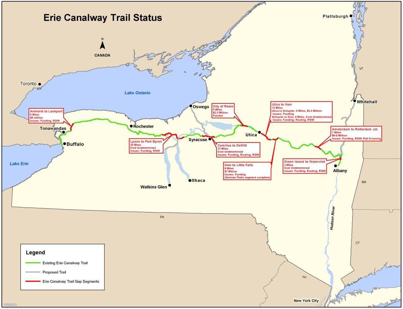 On this first Sunday of Spring, after enjoying a great lunch of pancakes and fresh maple syrup, at Stoney Ridge Farm, made by your fellow hikers, and helping our hiking club treasury by doing so, come to our starting point by the Erie Canal, at the east end of Macedon. Follow the directions to Stoney Ridge, on CR 28. After your lunch, turn right on 28 and, where it ends on SR 31, turn left, till you come to a small plaza (which has a Chase Bank), about 1/2 mile on your left, and meet us in the parking lot.
We will carefully cross 31 and hike east on the towpath, about 2 miles, till you come to a canal lock and park in Palmyra. Here, you can see how the canal locks helped the barges (and now, kayaks) negotiate the elevation changes encountered. Here, all hikers will have a choice. For those of you that feel that 2 miles is enough fun for you, we will spot cars at this point, to take you back to the start. If you prefer a 4 mile hike, simply turn around and walk back to the starting point.
Because weather, at the end of March, can be anything, we planned 2 choices for the after hike social. If the day was going to be nice and warm (at least 50), and the snow had melted to open up the parking lot, we would have taken advantage of the nice restrooms and picnic tables to have our first picnic of the year, where you bring a dish to pass.
Although the park in Palmyra is very nice, I somehow don’t think you would enjoy an outside picnic in 20 degree weather. A bowl of steaming chili in a heated setting sounds much better (and should keep the bedroom warm that night too). Therefore, using (or abusing) the authority you so kindly vested in me last Sunday, I advised Macedon Hills of our invasion after the hike and their hospitality will be extended to us. You can select your dinner from their extensive menu, along with your favorite beer or wine. From our staging area, turn left on 31, and the place will be about a mile down, on your left side.
There may still be snow on the towpath, in case you’d like one more try in your skis or snowshoes.
Low bridge, everybody down
Low bridge, we’re coming to a town
Where you gotta know your neighbor, and you gotta know your pal
Doing 15 miles on the Erie Canal
Dates: March 21, 22 and March 28, 29
Time: 10:00AM to 4:00PM
Open House:
Tour the Maple Shed
Taste testing
Maple Syrup demonstrations
Children’s maple activities
Our Store:
Maple Syrup
Molded candy
Maple cream
BBQ sauce
Pancake Breakfast – 10:00 – 3:00
Pancakes, Sausage, Coffee, Juice
Suggested donation: $7, children under 12: $5.
We would love to have you and your family come tour our maple shed. Come meet us and see how we make Maple Syrup. We will have tastings and demonstrations and lots of conversation.
Visit our Maple Store while you are here.
Between 10:00 and 2:00 we will be serving a pancake breakfast for you and your family. All you can eat pancakes, with sausage, coffee, tea and orange juice, are available for a contribution of $7. Vegetarian: $6, Children under 12: $5.
We welcome you to stop by and tour the shed!
 This is definitely a challenging hike description to write. Looking outside on March 9, I can definitely believe that we will be snowshoeing and skiing in twenty days. But remembering how the snow disappeared before Christmas, it really is hard to say.
With this hike, we are experimenting with recycling a previous hike, even though we do not have a hike planner scheduled. Please email the winter hike coordinator if you are willing to complete the planning of this hike. You will want to do a brief pre-hike the week before the hike, checking for current trail conditions and then update this hike description as needed.
 We have been working to keep the Wheaton Hill trails open. Mostly this means cutting out Multiflora rose while avoiding the Poison Ivy. This hike will give us a first view of these trails to help planning our trail maintenance for 2015. If you can’t walk past a Multiflora rose without clipping it back, bring heavy cloves and a pair of clippers. But we will be hiking the entire system of trails.
Please dress according to the weather, and expect wet ground if it is above freezing. You may find a change of pants and shoes make the social afterward more enjoyable.
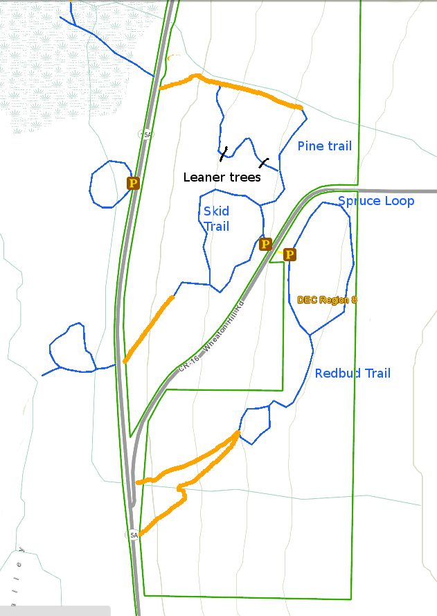
 Climbers will head up the Pine Trail, staying to the right to the edge of the gully. Being careful to stay out of the gully, this group will follow the gully downhill to the return trail Hardy souls may want to continue following the orange line on the map until they can see 15A and across to the Roots View Trail that heads out to the Hemlock inlet. After climbing back up the Pine Trail, this group will stay to the right and follow the Skid trail around and back to the cars. Again, at the half way point, an off trail hike along the middle orange trail will look for the route to 15A and the Green Ash Loop. Please skip the orange side routes if you think the steep climbs back to the main trail will be more than you are willing to do. This will depend on how much snow is still on the ground.
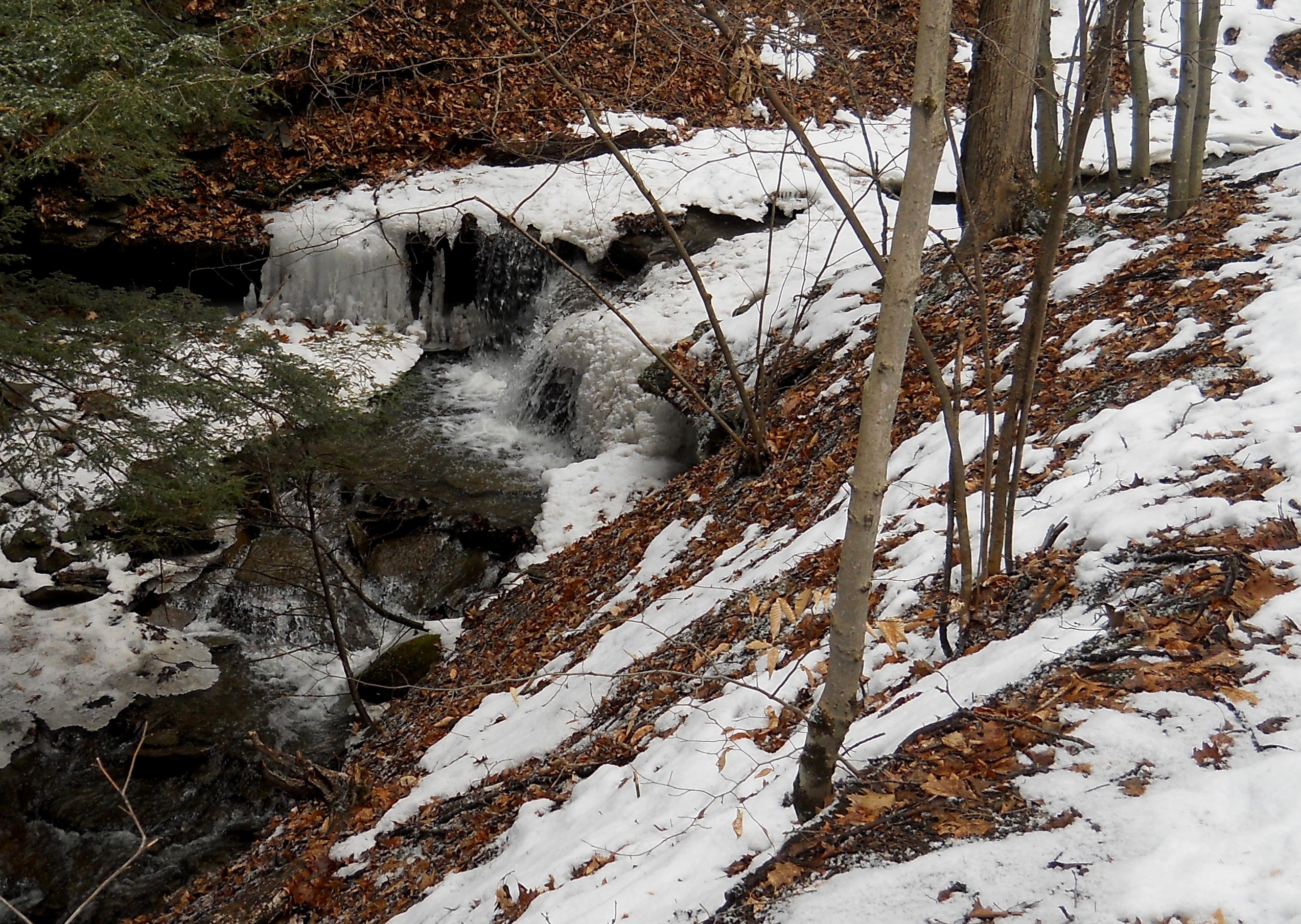
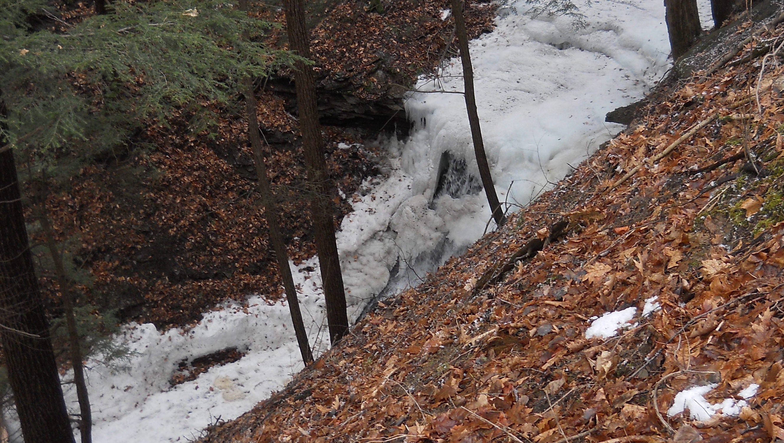
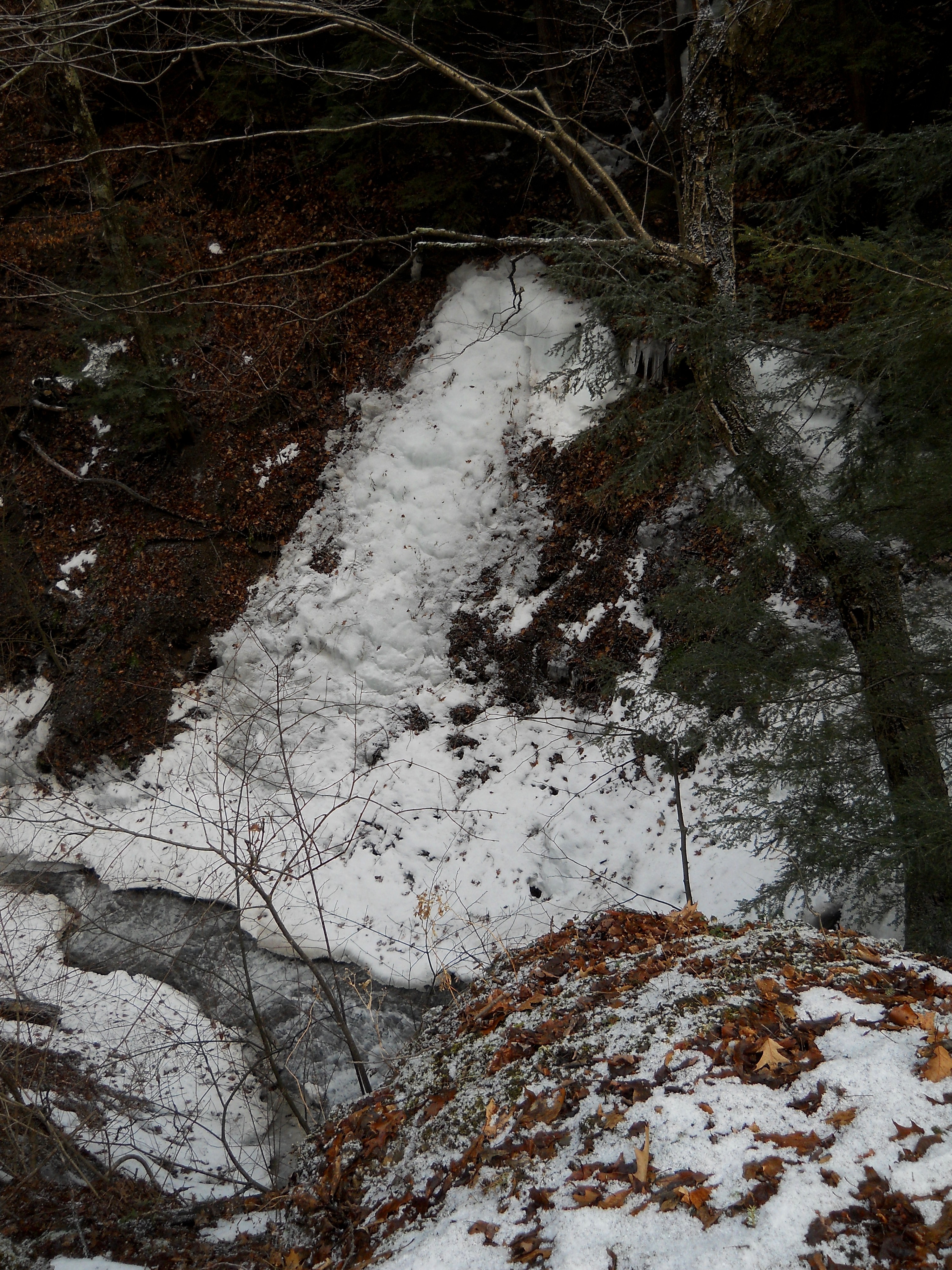
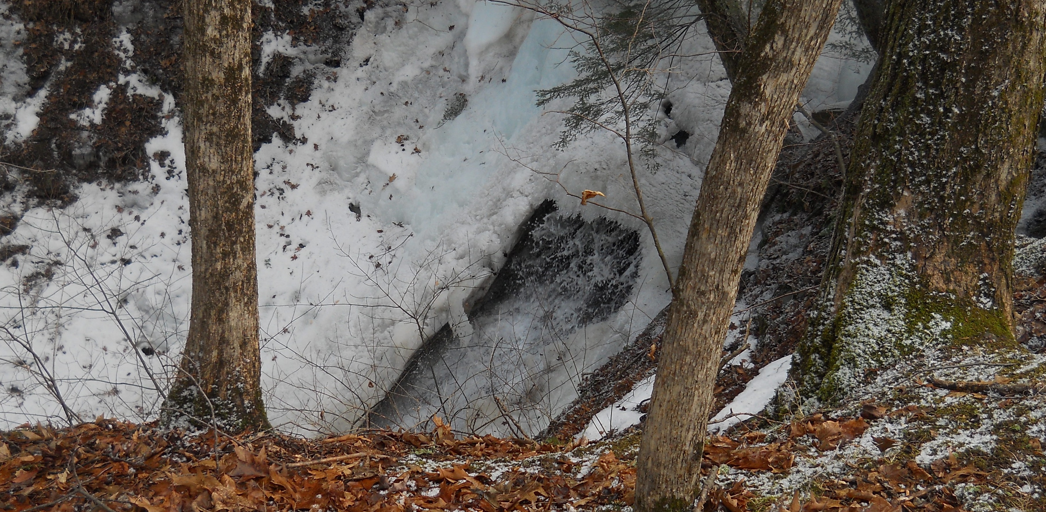 Tourists will follow the climbers up the Pine Trail to the gully and the waterfall. Pam reports that the waterfall is SPECTACULAR, with water running through the ice. Saftety is critical with ice and snow at the top of the gully. Tourists will turn around at the gully, returning on the high branch of the Pine trail to the start point. After crossing the road, they will turn right on the Spruce trail following it around, through the spruces and back to the start. Based on time, the tourists can then follow the Skid Trail, turning left out of the parking area and following the Skid Trail clockwise around.
Please park on Wheaton Hill facing down the hill – avoid parking on both sides of the road and be alert for cars while waiting for the start of the hike. Directions are available to the Wheaton Hill trailhead.
 After hike social will be at Pam’s house, about 10 minutes north of Wheaton Hill, just off RT 15A. (Details at the hike) Bring a dish to pass and your drink of preference. A “special maple glazed” meat will be provided as the main meal. We encourage our Sunday Maple Weekend pancake workers that are unable to attend the hike, to stop in for the social on their way home. Parking available on road or in driveway at this point, unless weather conditions change.
Looking for brochure.or mailing list so I can receive it in the mail.
Nothing opens up for mailing list.
There’s all kinds of very bizarre ads and post for viagra and other drugs above on calender page.
Please let me know if there’s a brochure available