
Hikes led by Springwater Trails are generally held on Sunday afternoons and appear in this calendar in green.
Hey, the weather predictions were correct – there is snow on the ground and the temperature at 9:00 is only 29° with a predicted high of 33, so we are cancelling the bike ride. BUT, we are hiking, so put on your orange vest and your hiking boots and come enjoy East Springwater by foot!
This Sunday we are offering something different – a bike or hike. (Well, maybe not so special since we are only hiking.) Come enjoy East Springwater either at a walking or a riding pace, according to your preferences.
This hike/bike is a part of the Bicentennial Celebration of Springwater.
Before we start, three cautions:
- This hike will start at our regular winter time of 2:00PM
- If you are hiking please wear orange or another bright color. This will be the second day of regular deer hunting season.
- If the temperature is below 40° then we do not plan to ride. .If you are unsure, please check the website Sunday at noon.
All hikers and bikers will meet at the barn at Punky Hollow near the corner of Pardee Hollow Rd and Tabors Corners Rd in Springwater. As always, please park carefully, as this is private property. Following the hike/bike, please join us for a social at John Larysz’s house. Bring a dish to pass and your beverage, or make a contribution ($5) to the social fund. Thanks John and Sue for volunteering your home.
Hiking above East Springwater
Hikers will hike on Punky Hollow trails. Based on the number of hikers, we will have one or two groups, both of which will follow trails through the woods to the top of the hill to look down on the Cohocton Creek and on Dutch Hollow. As time permits, we will explore the hill top and then return to the cars over a different trail.
Biking Dutch Hollow and Tabors Corners This hike is canceled due to the weather!
Dust those cobwebs off your bike and pump up those tires. Prepare to enjoy the hills of Tabors Corners on two wheels. Yes there will be a few elevation challenges on this ride. We will travel at a leisurely pace, but be prepared for some lovely scenery and a good workout.
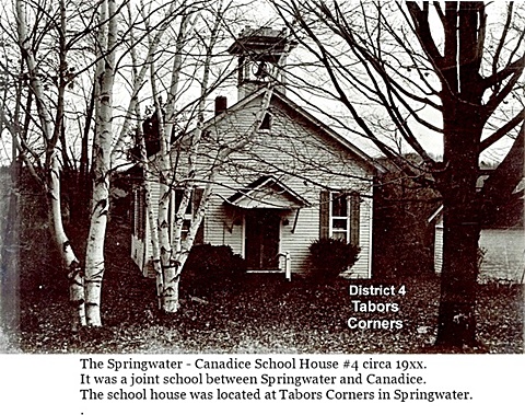
This ride will pass two former school houses in Springwater. Keep your eyes open to School #4 at Tabors Corners and Wetmore, and School # 17 on Pardee Hollow just before the end of the ride.
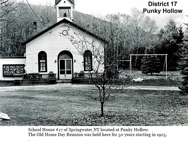 Bikers will meet at the Punky Hollow event building (site of the Fiddlers’ Fair), on Pardee Hollow Rd., ready to ride at 2:00 PM. Riders will head west on Pardee Hollow then north on Tabors Corners Rd. At the junction of Wetmore Rd. we will head north for another mile to reach the town line of Springwater at Tibbals Rd. From there we will head back south on Wetmore turning south on Tabors Corners Rd. The ride continues to Dutch Hollow Rd., which we will follow for about 4 miles back to Pardee Hollow, Turning right we will have a nice downhill cruise back to the parking area. Total distance is 11 miles.
If it the road is snow covered or the temperature is below 40 degrees the ride will be cancelled and we will walk with the hiking group.
From Springwater: Head north on NY 15A from the light in Springwater. Take the first right onto Wheaton Hill Rd. At the Tee at the top of the hill (3.4 mi), turn right onto Wetmore Rd. In 1.2 mi, at the stop sign, turn right onto Tabors Corners Rd. Take the first right in 1.8mi onto Pardee Hollow Rd. The Barn is on the right. Park in the driveway at the far end of the barn, or along the side of Pardee Hollow Rd.
From Wayland: Head east on NY 21 from the intersection with NY 15. in 3 miles, turn left onto CR 37. The road sign says Bowles Corners, although the road name is Tabors Corners. In 3.6 miles, turn right onlo Pardee Hollow Rd The Barn is on the right. Park in the driveway at the far end of the barn, or along the side of Pardee Hollow Rd.
From Honeoye: Head west on NY 20A. Turn left (south) on CR 37 at the Valley Inn. Continue staight onto Canadice Hill Rd in the hamlet of Canadice. In 2.4 miles, Ross Rd goes off to the right, but stay straight to stay on Canadice Hill Rd. .In 2.4 miles of dirt road, the road enters Springwater and the name changes to Wetmore Hill. Continue straight on Wetmore Rd. At the stop sign after going over the hill, turn right onto Tabors Corners Rd. Take the first right in 1.8mi onto Pardee Hollow Rd. The Barn is on the right. Park in the driveway at the far end of the barn, or along the side of Pardee Hollow Rd.
The after hike social at John’s, is just a few turns away on French Hill Rd. Directions will be available at the hike.
Weather Update Based on our pre-hike on Saturday,, we recommend snow shoes or possibly skis if you have them. The snow was 6 or 7 inches deep and it will be easier to be on top of the snow.
 Springwater is home to the highest point in Livingston County at 2244 feet above sea level. You can compare this to the highest point in the surrounding counties. Ontario County (Frost Hill) above Wesley Hill Preserve is 36 feet higher, and Steuben County (Jackson Hill) south of Canisteo is 156 feet higher. On the other hand, Hopper Hill west of Boughton Park in Monroe County is 1200 feet lower.
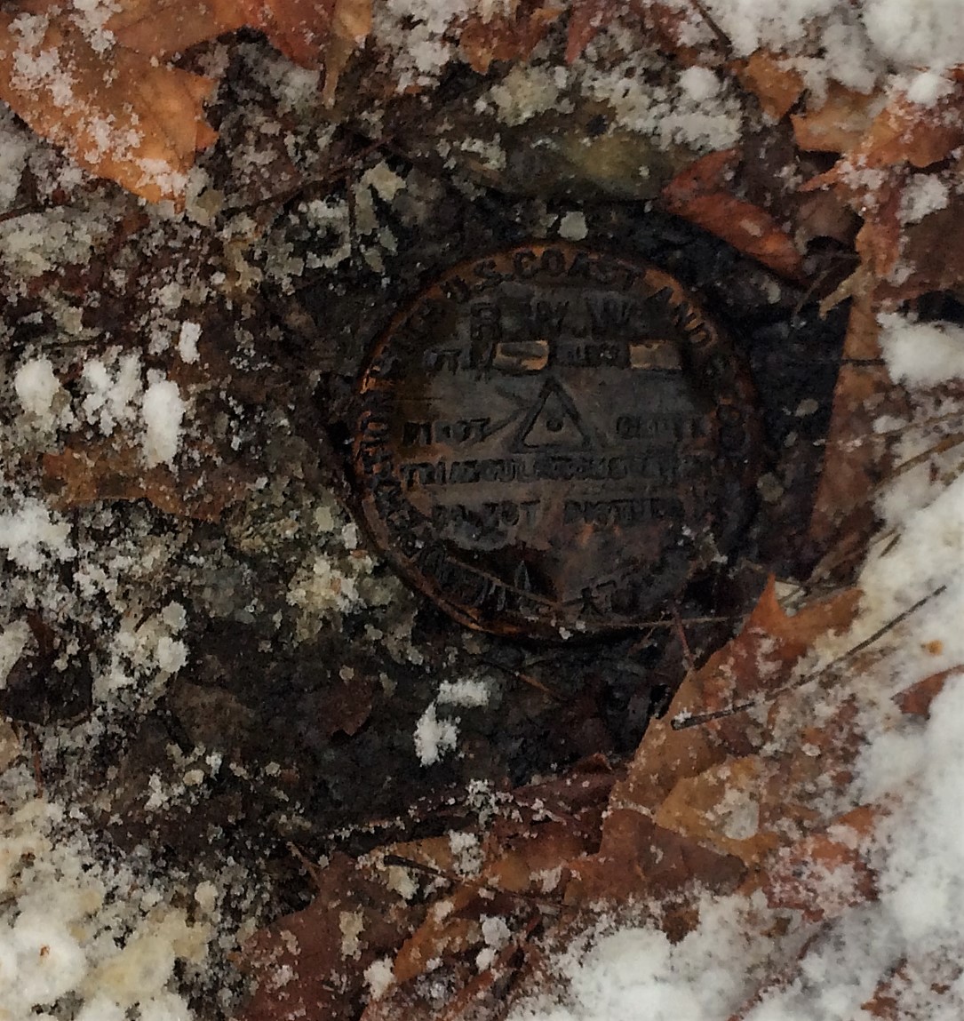
This Sunday, we will hike on New York State land in the north east corner of Springwater to the actual high point. We will start at the Ontario/Livingston county line on Wetmore Rd at 2000ft and will generally follow the snowmobile trail along the county line and then south through the woods to the highest point. The high point is on private land and we have permission this Sunday to see the actual benchmark placed in 1939. We will then continue south to Dutch Hollow Rd at about 1850ft.
Small portions of this hike will be off the trail, but overall it is not a difficult hike.
We will divide into two groups. The Naturalists/Tourists will primarily stay on the snowmobile trails and will cover 2.4 miles. They will end on Dutch Hollow Rd and we will carpool back to the start point. The Climbers will follow the same route, but will walk back to the cars, stopping to see another benchmark at the corner of Tabors Corners Rd and Wetmore Rd.
Following the hike, join us at John’s home on French Hill Rd. Directions will be available at the end of the hike. Please bring a dish to pass, your favorite beverage and your singing voice. We will do some seasonal singing around John’s piano.
Directions
From Springwater: Head north on NY 15A. In 0.8 miles, turn right onto Wheaton hill Rd. At the tee (in 3.4 miles) turn left onto Wetmore Rd. In 1 mile, park on the left side just before Tibbals Rd.
From Honeoye: Head west on US 20A. Turn left onto CR 37. In 3.7 miles, when CR 37 turns right, continue straight onto Canadice Hill Rd. Continue straight when Ross Rd turns slightly to the right. Go past Harriet Hollister Spencer SRA. At the Springwater Town Line, park on the right just past Tibbals Rd.
From Naples:
(Note that there are seasonal roads between Naples and our hike. If you want to use your GPS (good luck) and take the back roads, head first to the intersection of Garlinghouse and Pardee Hollow. Do not go over Richards Rd, Coates Rd, Liddiard Rd, Warner Rd or Feather St. If you want to get there without incident, follow the directions below).
Take NY 21 S through North Cohocton. Turn right in North Cohocton, to stay on NY 21. In 3.8 miles, turn right onto CR 37 (The sign says Bowles Corners). Stay on CR 37 as it becomes Livingston CR 36 (Tabors Corner Rd) for 5.4 miles until the first stop sign. Turn right onto Wetmore Rd. In one mile, park on the left side just before Tibbals Rd.
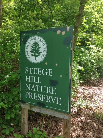
Located in Chemung County in the town of Big Flats, Steege Hil is a 794 acre preserve acquired in 2001 by the Finger Lakes Land Trust from an anonymous donor. In 1970, this area was nearly ruined by heavy logging. The Town of Big Flats took action to stop the degradation on the hill by shutting down the operation and passing a law regulating future logging within town limits. Now the original forest is making an impressive recovery. Numerous species of hardwoods prevail, mixed with conifers on the steeper slopes. Wildlife include black bear, timber rattle snakes, and Allegheny Mound Ants. Their distinctive nests can be found trail side and in open areas. For additional information and maps go to http://fllt.org/preserves/steege-hill-preserve
Steward, Bob Corneau has maintained a network of more than 6 miles of trails, mostly over old logging roads. It is our good fortune to be able to enjoy the quiet beauty of these tails on a winter afternoon, Check the Springwater Trails website on February 11 for an update on trail conditions. If there is snow we could ski or snowshoe.
Parking in very limited at this preserve so car pooling is strongly encouraged.
Hike Description
All groups will depart from the parking area on Steege Hill Rd. After a short but steep ascent, our groups will branch out as follows:
Naturalists will follow the yellow loop in a clockwise direction, enjoying some gentler terrain as well as views of the Chemung River and ponds. The ant mounds are numerous on this trail. Out nature experts will no doubt enjoy identifying the many varieties of trees and birds. Hike length will be about 2.5 miles.
Tourists will head our on the yellow loop in a counter clockwise direction, past the ponds and then onto the blue trail to loop through the forest back to the yellow trail. Views of the valley as well as the lower slopes should be nice. Hiking distance about 3.5 miles.
Climbers An ambitious journey awaits you, a complete circuit of the trail system.. This group will veer off from the initial climb to follow the white trail, traversing some significant ups and downs. They will sample the blue and red trails (more hills) before returning home on the yellow loop for about 5 miles. It’s all down hill on the return.
After Hike Social will be at Tag’s Restaurant on Rte, 352 in Big Flats.
Getting There Parking is VERY LIMITED. Roadside parking is not advisable. Please carpool from the Springwater Town Hall, leaving at 12:30. Drive time is about 1 hour 15 minutes.
 Directions: Take 390 South to I 86 East. Take Exit # 48. Turn Right on NY 352. Go 1.5 miles. Turn right on S. Corning Rd. (Chemung CR 10). Go .7 miles. Just after bridge turn left on Steege Hill Rd. Go 1 mile. Slow down. Parking is on left. Preserve sign is difficult to spot.
Social There is a great little joint called Tags, recommended by local folks. To get there, retrace your steps back to Rte 352. Turn right and travel about 0.6 mile. Restaurant is on the right. Menu is full of salads, burgers, wraps and apps. See it at tagsrestaurant.com
Trail conditions Update 2/11/17. Looks like freezing rain tonight and rain tomorrow. Best bet is to wear waterproof clothing and bring traction control devices/ hiking poles in case conditions are slippery.
Victor Hiking Trails (VHT) will be leading a hike this Saturday 3/25/2017 at 8:00 a.m. from “the Apple Farm” to Boughton Park, around the two ponds (aka former reservoirs) in Boughton Park and back to “the Apple Farm”, a distance of 9 to 11 miles, rated as strenuous and hilly. Guesstimate of 3.5 – 4 hour hike (thus end time on 12;00 Noon listed in the heading of this hike event announcement is an approximation). **Traction Devices (TDs) will be very helpful for this hike (understated), given terrain and known conditions at this time of year.
The hike is part of the hike series of Genesee Valley Hiking Club (& GVHG Meetup). All hikers are welcome. Anyone who is interested is encouraged to sign up on the GVHG Meetup. – – For this hike, parking and hike start point is at the Apple Farm. – –
(Of note, Springwater Trails hikers have hiked a few of our weekly Sunday hikes in Boughton Park.)
As in part described, this hike will cover not only parts of Boughton Park but also substantial mileage on the Seneca Trail and the spur trail that is within “the Apple Farm” (aka the Victor Apple Farm).
FYI – as was in the news – “the Apple Farm” (in Victor), located at 1640 NYS Rt 444 (on the west side of Rt 444), sustained a fire in the sales and office building on November 4th 2016, a total loss. The remainder of the farm structures and orchard remain intact, and intent is to rebuild a sales and office building.
The Apple Farm is one of many property owners who grants access for hiking trails on privately owned property.
One thought for a possible future hike – – plan a hike in the autumn at the Apple Farm, and provide for post hike apple picking (perhaps as a social event itself, or as part of a social that may be held at the Apple farm where picnic tables are provided, or separate from a social). A symbiotic hike event, such that the Apple Farm as landowners provides hiking trails (and access thereto), and hikers support the business of the landowners by purchasing apples and other goodies.
– – Back in the day, if this author recalls correctly, Maple Syrup from Sugarbush Hollow located in Springwater (owned by dearly departed Chuck Winship, a ST hiker and avid supporter of ST) was offered for sale at the Apple Farm store. – –
An educational Hike with Springwater Trails and Victor Hiking Trails with impetus and designed to identify and view BLUEBIRDS, … and more, held at MaryFrances Bluebird Haven (MFBBH).
Trail conditions update, gained from 5/6/2017 Saturday’s preview hike: very wet, rubber boots suggested. Bluebirds were observed. For this hike & potluck after-hike social event, perhaps we can agree on “cloudy with a chance of meatballs.” The hike is offered rain or shine.
Starting at 2:00 p.m. on Sunday, May 7th, 2017 will be a joint hike of Springwater Trails (ST) and Victor Hiking Trails (VHT). For ST this is our regular Sunday weekly hike. For VHT this is a special hike outside of the monthly guided hike held on the 2nd Saturday of each month.
This is a special educational hike event at MaryFrances Bluebird Haven (MFBBH), a Town of Victor park, located at 235 County Rd 9 in Victor, NY. – – MFBBH entrance driveway, leading to the parking lot, is located on the east side of County Rd 9 (aka Victor-Egypt Rd) just south of intersect with Valentown Rd (which intersects from the west).
HIKING GROUPS, TRAIL ROUTING, (and map hyperlinks):
The hike, will have two separate sub-groups. Routing will be be slow and easy on mostly flat terrain for the Naturalists/birdwatchers group covering ~1 mile (the whole of the perimeter trail) within the MFBBH park, Gene as Hike Leader. The second routing will be fast paced for the Climbers/Tourists group covering ~3 miles within MFBBH park & on adjacent Monkey Run Trails, Dave as Hike Leader. (Climbers/Tourists routing will include MFBBH perimeter trail (~1mile) & MR three loop trails ~2miles of woodland walk, all mostly flat terrain.) MFBBH map // Monkey Run Trails map
KNOWLEDGE & EQUIPMENT:
We will have multiple hike leaders who are knowledgeable about birds, so bring your binoculars and camera (and telephoto lens if you have one). Also, wear good hiking boots as there may be some muddy spots. Possiblity that TDs (Traction Devices) may be helpful, but certainly not required. Hats with a visor and sunglasses may also be useful.
– Some ST hikers seized the opportunity to attend a presentation program “All About Bluebirds” held at the Geneseo Riviera Theater on Friday March 10th, 2017, one impetus that spurred this 5/7/2017 hike. Tickets for “All About Bluebirds” presentation were essentially “sold out” well prior to show day. Those ST hikers who attended will be looking to put newfound knowledge to use on this 5/7/2017 Bluebird hike. (Some other ST hikers were tending to matters as result of the 80+MPH windstorm of Wednesday 3/8/3017 on that Friday.) –
Hikers will have opportunity to learn about the impetus and history of MaryFrances Bluebird Haven.
Please note: Dogs are NOT allowed on this hike. Alcohol, smoking, and weapons are not allowed per park regulations. Oh, … and leave your saddle and mount at home, because horses are not allowed in this park, thus you’ll need to choose another mode of transportation to this hike.
AFTER-HIKE SOCIAL:
There will be an optional after-hike social dinner at the Butler Cottage located in MFBBH park beginning at 4:00 pm ; bring a dish to pass or make a donation (suggested $5) to the social fund to help defray expenses, and bring your beverage of choice (no alcohol please), if you would like to meet your fellow hikers. You may bring your own tableware if you’d like, albeit, disposable plates, plastic utensils, etc will be on hand as at most ST potluck socials.
Butler Cottage is a totally enclosed edifice with electricity / lighting / indoor plumbing / full facilities: restroom, full kitchen (counters & cabinets, stove/oven, refrigerator, microwave, and yes the “kitchen sink” too complete with running water), etc. The main area with tables and chairs accommodates 45 people. So, there is availability for heating up dishes best served warm, refrigeration, etc. Some hikers may wish to avail themselves prior to the start of the hike.
PARKING:
MFBBH parking lot will accommodate ~ 20 cars. Additional parking can be had along the entrance driveway, with judiciousness & thoughtfulness in mind.
DIRECTIONS:
From Springwater (and select other points south of Victor):
~45+ minutes drive from Springwater hamlet’s 4 corners, travel NY Rt 15A northbound (to just s of hamlet of Hemlock) ; turn right/eastbound onto NY Rt 20A (eventually passing through the hamlet of Honeoye, and continuing on NY Rt 20A northeasterly to just south of the hamlet of Bristol) ; turn left/northbound onto Co Rd 2 aka Oakmount Rd, pass through the hamlet of Bristol and continue straight on what will eventually become Oakmount Ave, crossing NY Rt 20 <USE FOREMOST CAUTION at this crossing!> to jct with Main St in Village of Bloomfield ; turn right/eastbound on Main St ; turn left/northbound onto NY Rt 444 (aka Elm St which becomes Victor Holcomb Rd which becomes Maple Ave) to jct with NY RT 96 aka East Main St in the Village of Victor ; turn right/eastbound onto NY Rt 96 aka East Main St ; turn left/northbound onto Church St ; Church St becomes Victor-Egypt Rd aka Co Rd 9 ; travel to 235 Victor-Egypt Rd where Mary Frances Bluebird Haven driveway is located ; turn right onto the entrance driveway to the MFBBH parking lot.
From Rochester area: (center city, areas directly contiguous east, as well as north and west Monroe County areas) ~ a bit under 30 minutes drive from Rochester get on I-490 eastbound expressway and travel to exit 28 (for NY Rt 96 southbound, in Perinton) ; from the exit 28 ramp turn left/southbound onto NY Rt 96 south ; from NY Rt 96 south turn left/eastbound onto High St (which is opposite Eastview Mall’s southern-most entrance drive) ; from High St turn left/northeastbound onto Valentown Rd ; <take note of the Valentown Museum as you pass it on the left side of the roadway> drive Valentown Rd (to road’s end) the jct with Victor-Egypt Rd aka Co Rd 9 ; turn right/southbound onto Victor-Egypt Rd, and then a quick left/eastbound into the driveway for MFBBH.
[Alternatively, I-490 expressway to exit 26 for NY Rt 31 eastbound, to Victor Rd aka Co Rd 52 (which becomes Victor-Egypt Rd aka Co Rd 9) ; turn right onto Victor Rd and travel to 235 Victor-Egypt Rd driveway for MFBBH ; turn left/eastbound into the driveway.]
CARPOOLING:
Carpooling in name of efficiency is encouraged due to distance from Springwater and also in light that this is a joint hike with VHT.
Named sequential carpool points (unsupervised), corresponding with directions to the hike (as written above) are: (1) <gather 12:40PM, leave at 12:50PM> Springwater Town Hall at 8022 S. Main St (aka NY Rt 15), in Springwater ; (2) <gather 1:00PM, leave at 1:10PM> Hemlock Lake Park parking lot, located at the northern end of Hemlock Lake and accessed via Rix Hill Rd immediately off NY Rt 15A (and a bit south of the jct with NY Rt 20A) ; (3) <gather at 1:15PM, leave at 1:25PM> in the hamlet of Honeoye on south side of Main St (aka Rt 20A) in the Honeoye Commons Plaza (~ 8567 Main St) parking lot of CVS/Subway/etc, optimally you wanna park closest to Main St. The entrance drive for Honeoye Commons Plaza is the next entrance drive past the entrance drive for Shurfine/Dollar General stores. (additional reference point: Honeoye Commons Plaza is ~ opposite Honeoye Central Schools).
Please note this sequential carpooling arrangement is set up so that those from further south will make a stop at each further north sequential carpool point, and potentially take on added passengers or reconfigure. There is an allowance of ~ 5 minutes from arrival to departure at each, to allow for loading, and not much fudge factor beyond that. Assuming all goes well, arrival at MFBBH for the hike is calculated to be ~ 1:55PM.
Additional information: can be gained from checking the VHT website, Facebook, Meetup or the VHT voice message line [phone: (585)- 234-8226], as well as checking the ST website for updates.
SPRINGTIME BIRDING:
An additional Article on “Birding” on the ST website, in anticipation of this Bluebird hike, for those who wish to learn a bit more about “Birding” in Springtime.
Subnote: (reference to a future hike)
Hikers may wish to take note of Valentown Rd (nearly opposite MFBBH entrance driveway), as a future ST hike will in part refer to historic “Valentown” which is situated at the western end of Valentown Rd & High St (in the Town of Victor), about two blocks away from present day Eastview Mall.
Hints: * Valentown was built in anticipation of a chartered railroad that was never built, the CNY&N RR (Central New York & Northern). This railroad was a one-time planned northern extension of the CNY&W RR (Central New York & Western), and was akin to the CNY&W. Come August 1, 1899, the CNY&N was consolidated with its parent company the CNY&W.
** (spoiler alert!) The CNY&W was a predecessor in lineage of the PS&N RR (Pittsburg, Shawmut & Northern), and August 2, 1899 the CNY&W was merged with a number of shortline railroads in Pennsylvania into the newly formed PS&N RR. Both the CNY&W and the PS&N in successive lineage routed high above Stony Brook Glen through what is present day Stony Brook State Park. Both respective sets of railroad high bridge abutments that remain in Stony Brook Glen were in this railroad lineage.
(credit to the book by Paul Pietrak “The Pittsburg, Shawmut and Northern Railroad Company” for some information cited herein.)
Annually, one of two big shindigs (of a hiking variety) that Victor Hiking Trails (VHT) sponsors, is National Trails Day (NTD) observed the first Saturday of June. In 2017, the 25th year for this event in Victor, the date is June 3rd and the starting location is at Ganondagan State Historic Site Visitor’s Center located at 7000 Boughton Hill Road (County Road 41) .
VHT is of course one of many hiking groups that plans some organized observance on NTD. Yep, that word “national” does in fact imply many groups across the USA observe or celebrate NTD in some manner. Now, before I describe more about NTD activities, you were wondering what the other big shindig that VHT has annually. Weren’t You? Answer: the second big shindig VHT does is the VHT “Challenge Hike” usually held in late September.
NTD in Victor with VHT is usually three serial hikes, with a break in between each of the three hikes for rest and refreshment. The first hike is a morning hike and the last hike finishes in the afternoon.
You can read about National Trails Day from 2017 in the the VHT newsletter The Pathfinder Spring 2017 edition (volume 22, issue 1, page 1). And of course, you can check the VHT website for updated details about the NTD hike for June 3rd, 2017.
If you’re Interested in past years NTD in Victor, …two most recent years are cited: National Trails Day from 2016 in the VHT newsletter The Pathfinder 2016 Spring edition , and from 2015 The Pathfinder Spring 2015 edition (volume 20, issue 1, page 6).
Chimney Bluffs State Park, on the Lake Ontario southern shoreline in eastern Wayne County, just east of Sodus Bay is indeed a unique place, and a quintessential hiking destination. This locale is distant enough from the Springwater and surrounds area such that not likely that Springwater Trails (ST) would plan a hike here … due to the travel distance. BUT, HOLD ON, … for those interested in hiking this destination with a group of like minded hikers, well, Victor Hiking Trails (VHT) is leading a hike here on Saturday, August 12, 2017. All hikers are welcome. And of course, ST & VHT as organizations share numerous common bonds.
This hike will be a good opportunity to see this unique scenic area, and the erosion caused by the high levels of Lake Ontario that have been the case in this 2017 Spring & Summer season. Chimney Bluffs area is constantly changing due to the geological make-up of this place. Erosion is a constant here, and increased erosion in 2017 hastens the change and loss at Chimney Bluffs. The uniqueness of the area is always under constant change, and erosion eventually claims the various geologic formations here, … sometimes sooner rather than later.
Any updated details can be gleaned from the Victor Hiking Trails website.
The published basics of the hike are:
-
VHT will meet in the parking area behind the Victor Town Hall (85 East Main St) at 9am, and carpool to the hike.
-
Hike Chimney Bluffs State Park
On Saturday, August 12th, Victor Hiking Trails will lead a hike at Chimney Bluffs State Park in Wayne County, NY.
There are 4 miles of moderate trails through woods, meadows and along the shore of Lake Ontario. Comfortable hiking boots are recommended. Please, no pets on this hike.
Bring insect repellent, sunscreen, something to drink and a snack.We may stop for lunch on the way home.
Meet in the rear parking lot of Victor Town Hall, 85 East Main Street, at 9:00 A.M. to carpool to the trailhead. Or meet at the park entrance located at 7700 Garner Road, Wolcott, NY 14590 at 10:15 A.M. There is a $5.00/per car fee.
Check the website www.victorhikingtrails.org, Facebook, Meetup or the voice message line (234-8226), for additional details.
Annually, one of two big shindigs that Victor Hiking Trails (VHT) sponsors, is National Trails Day (NTD) observed each year on the first Saturday of June. In 2018 the date is June 2nd. VHT is of course one of many hiking groups that plans some organized observance on NTD. Yep, that word “national” does in fact imply many groups across the USA observe or celebrate NTD in some manner. Now, before I describe more about NTD activities that VHT hosts, you were wondering what the other big shindig that VHT has annually. Weren’t You? Answer: the second big shindig VHT does is the VHT “challenge hike” usually held sometime around late September.
NTD in Victor with VHT is usually three serial hikes, with a break in between each of the three hikes for rest and refreshment. The first hike is a morning hike and the last hike finishes in the afternoon.
Details for 2018 are: On Saturday, June 2nd, Victor Hiking Trails will host the 26th annual National Trails Day in Victor. Come to Finger Lakes Community College, Victor Campus, located at 200 Victor Heights Parkway, Victor, NY 14564, at 8:30 a.m. for a free continental breakfast. There will be three easy hikes beginning at 9:00 A.M., bottled water and snacks, a free pizza lunch with drinks and raffle prizes. Everyone who completes all three hikes will receive a free one-year membership to Victor Hiking Trails.
You can also read about National Trails Day 2018 in the the VHT newsletter The Pathfinder Spring 2018 edition (volume 23, issue 1, pages 2 & 7). A direct hyperlink to a VHT webpage about NTD 2018 is here. And of course, you can check the VHT website for updated details about VHT’s NTD hike for June 2nd, 2018.
Webinar: Tuesday July 16 2019 at 12:00 Noon
Speaker: Dr. Lori Spears, USU Assistant Professor
Date: Tuesday, July 16, 12:00 pm (MDT) – Please ignore the date in the title; it is an unavoidable posting date and NOT the date of the webinar!
The spotted lanternfly has been identified as a nasty invasive insect that is busy killing trees in Pennsylvania. The forestry and university authorities in PA have launched a series of webinars aimed at educating hikers such as ourselves in identifying and reporting these marauders. There’s is one coming up on 16th July; you are invited to join in from the comfort of your own home – we may be able to help limit this beast in New York.

Spotted lanternfly is an invasive planthopper that is native to parts of Asia and was first detected in the U.S. in Pennsylvania in 2014. Spotted lanternflies feed on a wide range of host plants, including grapes, fruit trees, hops, and hardwood ornamental trees. This presentation will cover the biology, identification, and possible control options for spotted lanternfly and other invasive landscape tree pests, such as emerald ash borer and Asian longhorned beetle.
Lori is the Cooperative Agricultural Pest Survey (CAPS) Program Coordinator at Utah State University. The CAPS Program is a federal program coordinated by the United States Department of Agriculture (USDA) Animal and Plant Health Inspection Service (APHIS) Plant Protection and Quarantine (PPQ), and whose goal is to protect U.S. agriculture from introductions of high risk invasive pests by conducting early detection surveys and providing outreach and education programs that support and enhance efforts to prevent new exotic pest entry and establishment. Her research and outreach programs have focused on the ecology and management of invasive insects and using bycatch from early detection surveys to learn more about beneficial insects, such as pollinators and lady beetles. Lori received a PhD in Ecology from Utah State University in 2012.
Co-sponsored by Utah State University Integrated Pest Management Group
|
|||||||||||||||
Volunteers Needed for Invasive Species Restoration Team!
Cumming Nature Center is seeking volunteers to help restore its nature preserve in Naples, NY, this summer, with a kickoff event during Invasive Species Awareness Week! Join us on Thursday, July 11, 2019, from 9 am to 2 pm, to help remove Japanese Barberry! Please contact Cumming Nature Center at (585) 374-6160 to sign up or for more information! Cumming Nature Center is located at 6472 Gulick Road, Naples, NY.
Cumming Nature Center seeks large and small groups, as well as individuals, to help remove Japanese barberry infestations so that we can seed native plants, restore native habitats for wildlife, and protect the surrounding Honeoye Lake watershed. Japanese barberry is an invasive shrub which is spreading throughout our Naples preserve, harming and eliminating our native habitats. We welcome everyone to come join our ongoing Restoration Team!
Please wear long work pants, long sleeves, socks, and boots or work shoes, since removing Japanese barberry is somewhat like working with rose bushes. And bring a water bottle and lunch! Cumming Nature Center will provide directions, equipment, and protective gloves and gear, so that we can work efficiently to combat this invader! CNC will have water available and provide light refreshments after..
Can’t make this event? Further invasive removal events at Cumming Nature Center are listed below:
Saturday, July 20, 2019
Thursday, August 1, 2019
Saturday, August 10, 2019
Sunday, August 11, 2019
Saturday, August 31, 2019
Saturday, September 7, 2019
Thursday, September 19, 2019
Saturday, October 5, 2019
Thursday, October 17, 2019
Saturday, November 2, 2019
— Cumming Nature Center
Looking for brochure.or mailing list so I can receive it in the mail.
Nothing opens up for mailing list.
There’s all kinds of very bizarre ads and post for viagra and other drugs above on calender page.
Please let me know if there’s a brochure available