
Hikes led by Springwater Trails are generally held on Sunday afternoons and appear in this calendar in green.
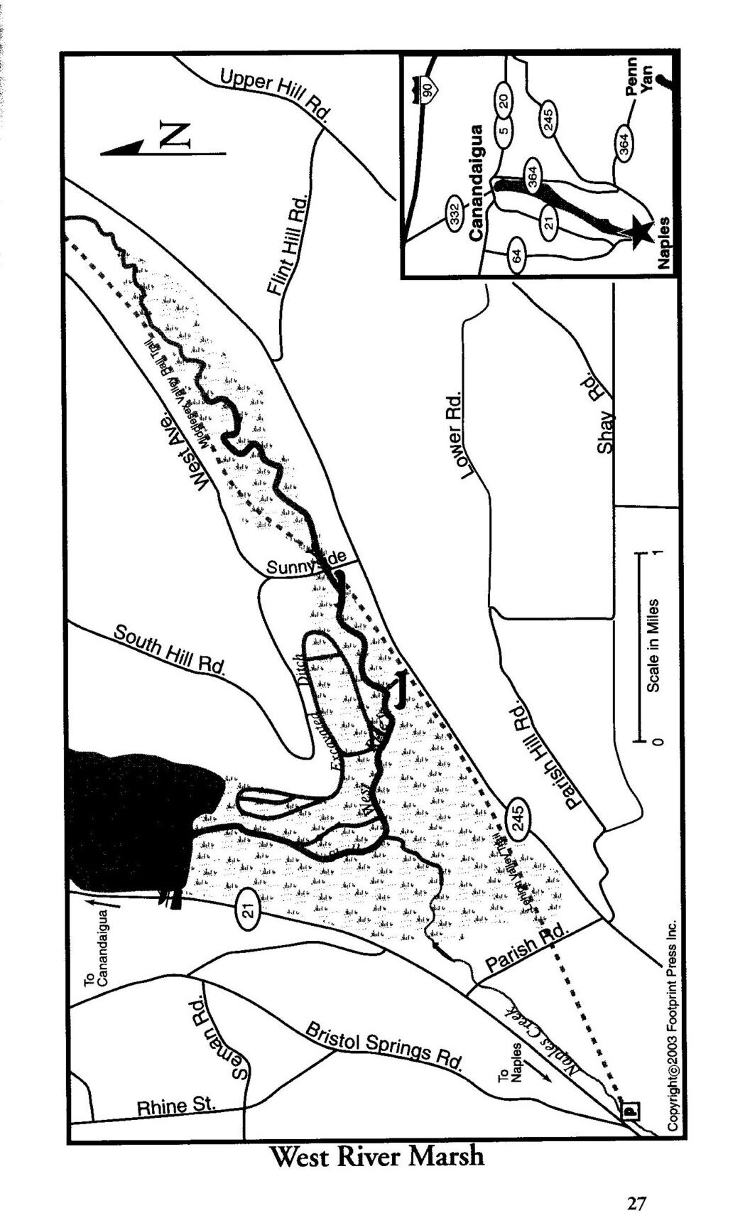 This event will combine a downstream paddle on the West River and a hike on the Middlesex Valley Rail Trail (aka the Lehigh Valley Trail). The best time to paddle this waterway is Spring. Let’s hope we have timed it right. According to Native American legend, this is the birthplace of the Seneca Indians. For images and additional information http://www.ilovethefingerlakes.com/rivers/west.htm
Paddlers The West River is a lazy stream, so we will be able to do an out- and -back with no problem. Launching at the Sunnyside Bridge, we will head downstream through a marshland full of waterfowl, turtles, and possibly eagles and osprey. Distance will depend on conditions, but likely 4 miles round trip (2 hours). PLEASE ARRIVE AT LEAST 15 MINUTES EARLY, READY TO LAUNCH AT 4:00.
Hikers The rail trail is a level path that parallels Rt 245 for 2.6 miles from Sunnyside to Parrish Hill Rd. There will likely be mud, so dress accordingly. The easy terrain lends itself to observing the surprises that nature has to offer. You might want to bring a camera. Distance will depend on hikers choice.
Directions From Route 21 in Naples head northeast on Route 245. Turn left on Sunnyside Rd and park on the left before the bridge at the brown and yellow DEC sign “West River Fishing Access Site”. Parking for 4-5 cars.
Social For those who wish to gather after the event, the Community Park on Route 245 just east of Naples has a large picnic area with tables and pavilions. Please bring your own food and drinks. Social distancing will be observed. Masks are also advisable.
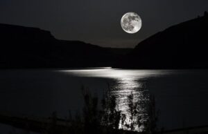
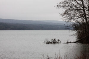
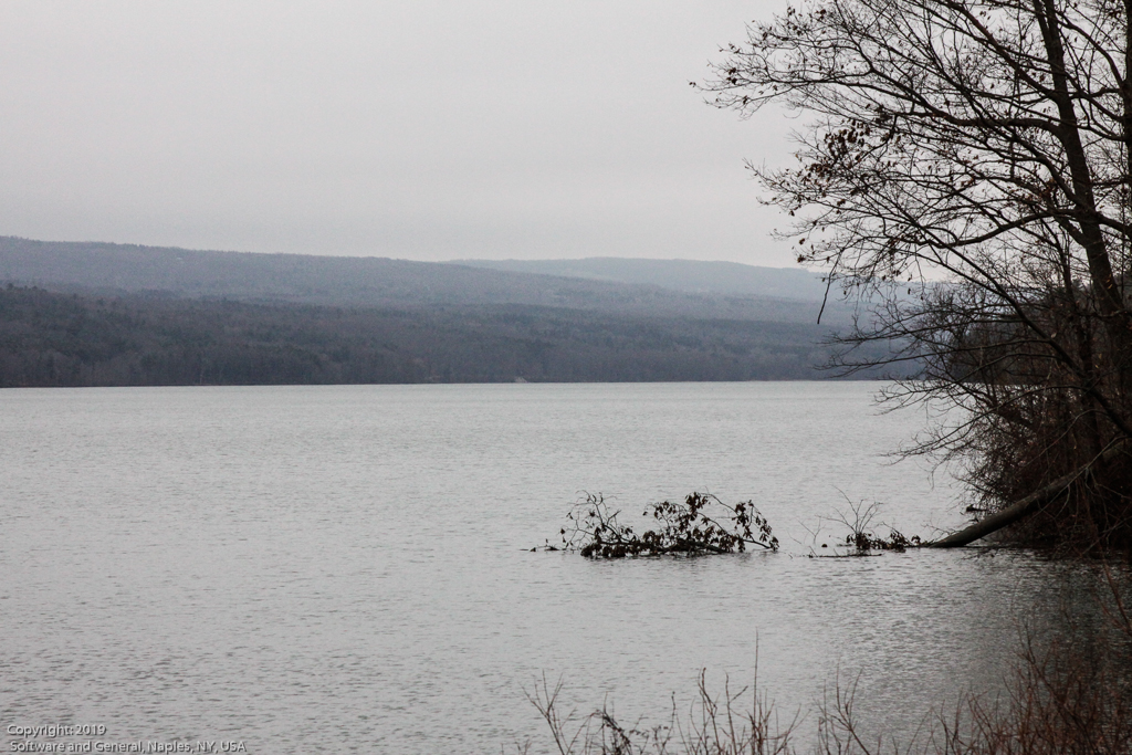
The next full moon is on Monday August 3rd – next Monday! If the skies are clear then we’ll be paddling in the brilliant moonlight on Canadice Lake. This isn’t actually a picture of Canadice Lake, but it’s what I’m hoping to see on this outing.
 The moon rises at about 9:00pm that night and is up all night. We’ll meet at the Canadice Lake Northeast Boat Launch ( 42.724077, -77.564481 ) on Canadice Lake Road in Canadice, NY at 8:45pm for a 9:00pm launch; I’m not sure when the night will be fully dark but it should be close to that time. We should see the moon come up over the hills and then paddle around until we’ve had enough. Howling at the moon will be tolerated on this night only.
Since it will be dark apart from the extreme moonlight that’s expected, we ask that all boats stay together on this paddle. If someone drifts away or gets lost then they will be hard to find in the darkness.
THIS IS ONLY WORTH DOING IF IT’S A CLEAR NIGHT! If it’s cloudy or rainy the event is automatically cancelled!
Please note this hike will begin at 1:30, as the Park closes at 4:00.
This Sunday’s hike will introduce us to new territory. Abe Lincoln Park is 182 acres of lovely trees, located along the southeastern shore of Irondequoit Bay, in the town of Penfield. It is an oasis nestled within a bustling commercial and residential area. The trails meander through several small glens or gullies and in places afford lovely views of the bay with its resident swans. It is a very popular destination for families, as there are several play areas for children in the front area. The hiking trails extend into the woods beyond the playgrounds. The parking area on Empire Blvd is small, 20 vehicle capacity. There is another parking area at the north end,]. If needed we could relocate the start of the hike to there. The trails are rocky in places with some steep sections. Sturdy hiking shoes/boots and poles are advised.
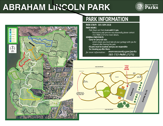 All hikers will begin from the same point of the main trail (white trail) which is well blazed. Depending on the number of folks and ability levels, we will branch out from this trail onto some of the secondary trails. Trail maps will be provided to the leader of each group. Naturalists will want to take a slower pace on a shorter route out to the edge of the bay on the Green Trail, less than 2 miles. Tourists may decide to go the length of the White Trail, at a slower pace than the climbers, 3miles. Climbers will go the full length of the White Trail plus explore some of the Red and Orange Trails, about 4 miles.
Social For those who wish to gather in the parking area after the hike, please bring your own snacks and beverages. Social distancing will be observed and masks should be worn.
Directions Follow 590N to the Empire Blvd exit. Go east on Empire Blvd., pass Irondequoit Bay then uphill to Abraham Lincoln Park on the Left near Daytona St.
Join the Canandaigua Lake Watershed Association at Bare Hill to learn more about the gypsy moth infestation. You will learn to identify and remove gypsy moth egg masses. This is one of three events scheduled for Saturday, April 17; Friday, April 24; and Saturday, May 1, from 10:00 a.m. to 12:00 p.m. You are encouraged to register early to allow the organizers to gauge interest and ensure proper supplies are available.
Join the Canandaigua Lake Watershed Association at Ontario County Park to learn more about the gypsy moth infestation. You will learn to identify and remove gypsy moth egg masses. This is one of three events scheduled for Saturday, April 17; Friday, April 24; and Saturday, May 1, from 10:00 a.m. to 12:00 p.m. You are encouraged to register early to allow the organizers to gauge interest and ensure proper supplies are available.
Join the Canandaigua Lake Watershed Association at Stid Hill to learn more about the gypsy moth infestation. You will learn to identify and remove gypsy moth egg masses. This is one of three events scheduled for Saturday, April 17; Friday, April 24; and Saturday, May 1, from 10:00 a.m. to 12:00 p.m. You are encouraged to register early to allow the organizers to gauge interest and ensure proper supplies are available.
NOTICE: The expected mud on the steep trails has forced us to cancel our hike on Clark Gully.
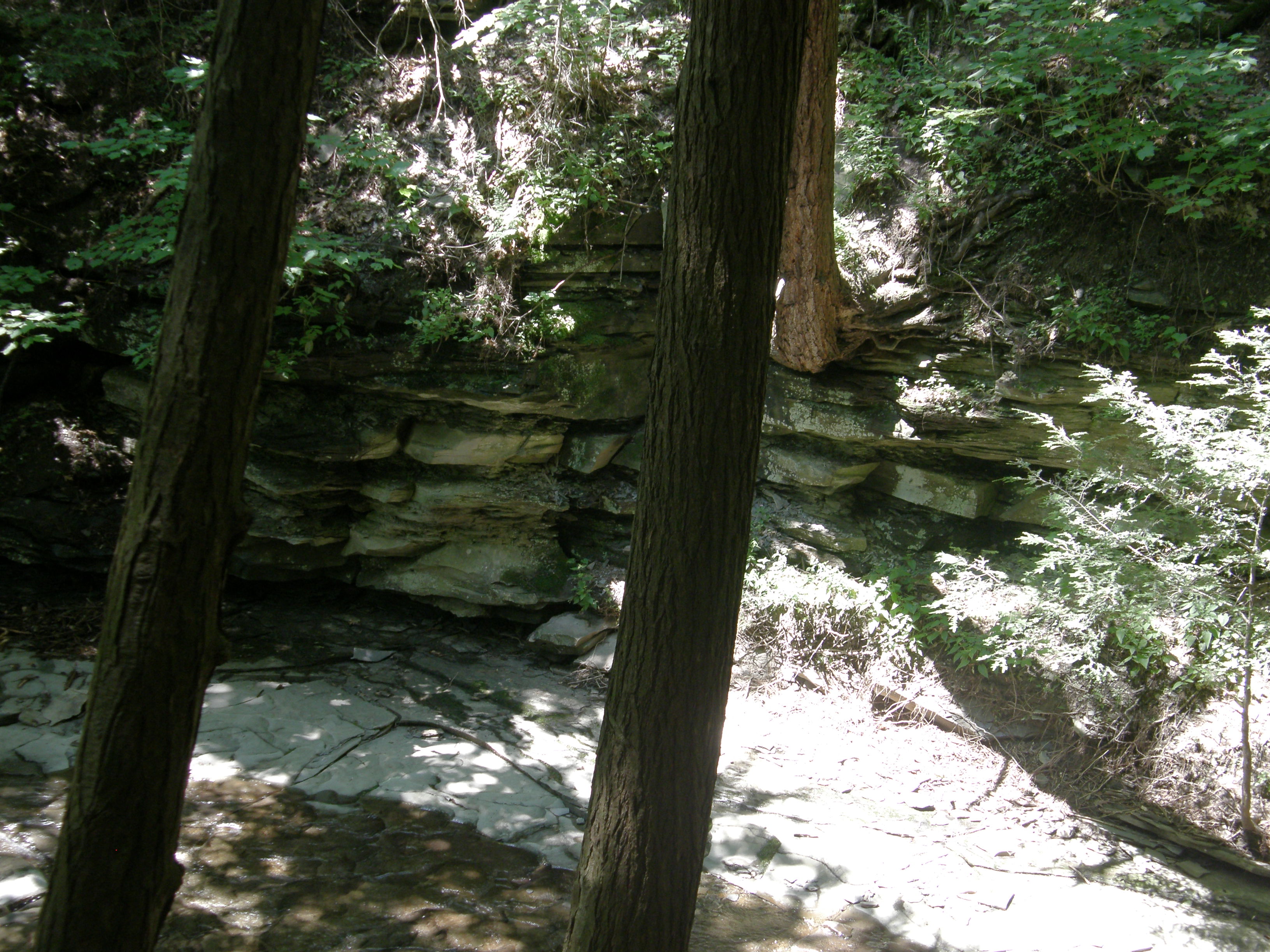
On Sunday we will return to Clark Gully on the south east side of Canandaigua Lake. This gully is a part of the High Tor Wildlife Management Area which is less developed than the area south of 245, but it is popular none the less.
We will offer hikers two hikes, one on the east side of the gully, starting at the bottom. The other will be a bit easier, starting up high on the gully off of South Hill Road. Both hikes will be in and out.
The Climbers will head across the road from the DEC parking area. After a short walk along the creek that comes down the gully, we will head up a quite steep hill, enjoying the exercise and the views back across the West River. This is a steep climb and our speed will depend on each individual hiker. At the top we will continue on the trail down to the creek, for any hikers so inclined. After cooling off near the creek, the Climbers will follow the same trail back to the cars.
The Naturalists will drive on Sunnyside Rd toward the lake, staying to the right on South Hill Rd. Parking is available on the right side after the road enters the town of Middlesex and becomes seasonal. We will hike across the field into a forest on an outcropping between two gullies. After the first steep downhill the trail branches, with the left branch heading down to the creek and the right branch following the ridge down steeply to an overview of the valley. After the view, we will need to climb back up, so each hiker can decide how far they wish to go.
Following the hike, join us for a dish to pass social at the Naples Community Park on the left of rt 245 before you reach the village. In case all the picnic tables are taken, you may want to bring a chair along with a dish to share and your own beverage.
Directions: Drive to Naples. Off Rt 21 across from Bob & Ruth’s, turn onto Rt 245. Drive 3.9 miles toward Middlesex. You will pass a DEC boat launch (west river) on the left side about a mile before your left turn onto Sunnyside Road. Drive about a mile to a “T” in the road. There is a DEC parking lot off to the right. We will all meet there for the hike.
The Hike:
A First Day hike along Canadice Lake.
Start the New Year the way you mean to go on – come for an inspiring hike along Canadice Lake! This is an easy, 1.8-mile each way hike along the shore of the lake; the trail is level and well-maintained and the lake views are lovely. For most hikers it will be a walk along the lake for an hour or so, and then back the same way; more enthusiastic hikers can veer off on Rob’s Trail that leads over the ridge and down to Hemlock Lake – this is a moderate to hard trail with several steep uphill and downhill sections. We’ll take a roll call the day of the hike if anyone wants to walk Rob’s Trail. We’ll arrange for transport back for those who only want to walk one way. Dress appropriately for the weather, carry water and some energy food, and carry a walking pole if it helps. Leashed pets are welcome.
A First Day hike along Canadice Lake.
This is not a “routine” Sunday hike – for a start, it’s happening on a Saturday! The hike is promoted by the NYS DEC, and is part of a larger program of First Day Hikes to encourage people to get out and experience the magnificent Sate of New York that they live in.
The Meet-Up Location
All First Day hikers should meet at the parking area off Purcell Hill Road, Town of Canadice, Ontario County. Google Maps (leaves this website)
The Social
There won’t be an organized social on this hike.
The Hike:
Start the New Year the way you mean to go on – come for an inspiring hike along Canadice Lake! This is an easy, 1.8-mile each way hike along the shore of the lake; the trail is level and well-maintained and the lake views are lovely. For most hikers it will be a walk along the lake for an hour or so, and then back the same way; more enthusiastic hikers can veer off on Rob’s Trail that leads over the ridge and down to Hemlock Lake – this is a moderate to hard trail with several steep uphill and downhill sections. We’ll take a roll call the day of the hike if anyone wants to walk Rob’s Trail. We’ll arrange for transport back for those who only want to walk one way. Dress appropriately for the weather, carry water and some energy food, and carry a walking pole if it helps. Leashed pets are welcome.

This is not a “routine” Sunday hike – it’s special because the hike is promoted by the NYS DEC, and is part of a larger program of First Day Hikes to encourage people to get out and experience the magnificent Sate of New York that they live in. The DEC, State Parks, and the Canal Corporation invite New Yorkers to kick off 2023 by participating in one of the many hikes being held at state parks, historic sites, wildlife areas, trails, and public lands across the Empire State. All hikers will leave with a memento of the hike and will be eligible to win an Empire Pass the allows entry to most state parks across the state.
Please note that the First Day hike this year is at 2:00pm Monday, giving everyone a little more time to get over the night before.
The Meet-Up Location
All First Day hikers should meet at the parking area off Purcell Hill Road, Town of Canadice, Ontario County. Google Maps (leaves this website) Click here for directions.
The Social
There won’t be an organized social on this hike.

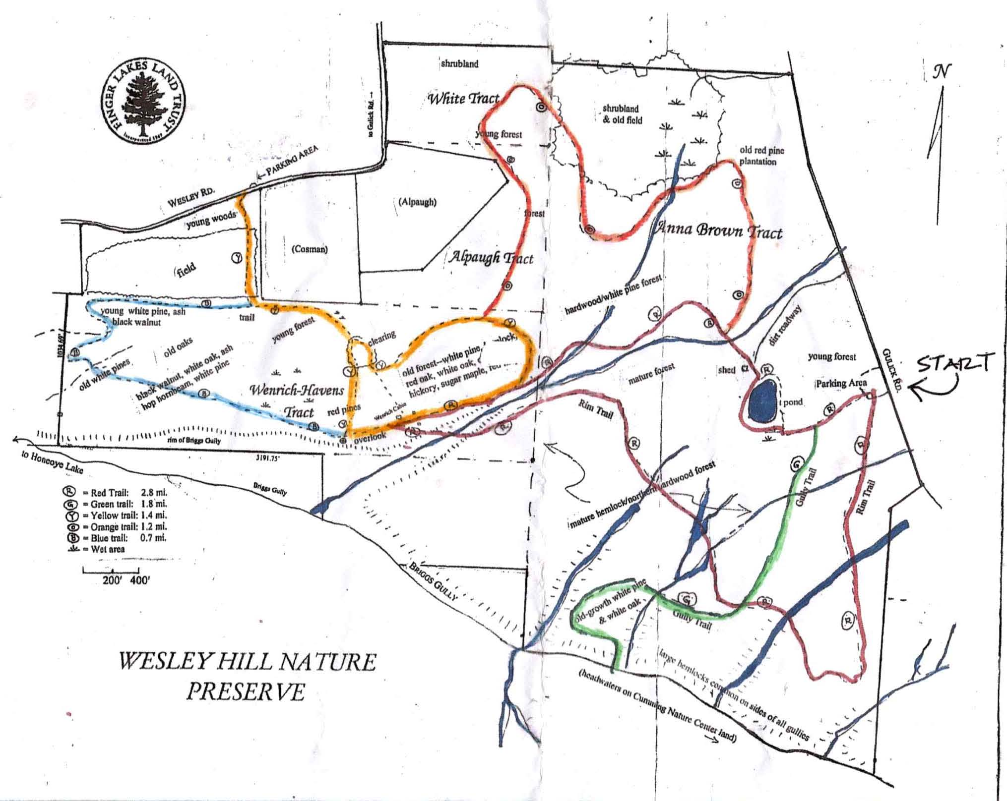
Although we have visited this preserve numerous times over the years, it is good to pause and reflect on the history of this gem of the Finger Lakes. Over one hundred years ago, after the sawmills of the Bristol Hills fell silent, white pine, hemlock, and oak seedlings began to sprout along the northern rim of Briggs Gully, one of the largest gorges in the Finger Lakes. The peaceful beauty of the forested glens and groves inspired three artists–John Wenrich, James Havens, and Colburn Dugan–in 1926, to purchase a 90 acre parcel which forms part of the preserve. They built the cabin, which we will visit on our route, as a retreat. Their children, who inherited this small paradise, entrusted its care to the Finger Lakes Land Trust, who purchased it and additional parcels in 1999, then added a land grant from Chris White to create what is now the 390 acre Wesley Hill Preserve.
At this time bowhunting is permitted on 2 of the trails (Blue and Yellow) thus they are closed to hiking. Please respect this. Our hikers will be traversing the Red, Orange, and Green Trails.
All hikers will meet at the Gulick Road Parking area. Please be ready to hike at 2:00 PM. Hiking boots and poles are highly recommended as the terrain is uneven and slippery in places. To begin, all groups will head west on the Red Trail, around the pond and into the woods.
Naturalists will follow the Red Trail downhill toward the cabin along a lovely gully. The cabin is in poor condition, but provides a glimpse into the past. There is a guest book and some interesting artifacts on the porch. Hikers may be able to proceed a short way past the cabin on the Yellow Trail to a terrific overlook of Briggs Gully and Harriet Hollister Recreation area in the distance. If there is a closed sign, then they will need to head back up hill on the Red Trail to the pond and Parking area. Hike distance about 2 miles.
Tourists Shortly after the pond this group will turn right onto the Orange blazed trail. They will follow this trail for1.2 miles to an intersection with the Yellow Trail. Turning left on Yellow will lead for .1 miles through the woods to the Red Trail . At this point they can turn right downhill and walk to the cabin and Briggs Gully overlook. They will then turn back up hill on the Red and follow it back to the pond and parking area. Total Distance about 3 miles.
Climbers Be prepared for some climbing. Following the Red Trail downhill from the pond, at the cabin turn left on Red down into a lovely gully and stream. There is a steep uphill from the stream, up some rock steps with a railing and rope to help you climb. Please use caution. The Red Trail continues uphill along the gully, then flattens out at .7 miles where it reaches the Green Trail intersection. The plan is to turn right and proceed downhill for .4miles into the famed Briggs Gully. It is a steep rocky trail, but worth the trip. If folks are not up for it, we can simply continue on the Red Trail which leads back to the parking area. Total trip about 4 miles.
From Honeoye: take route 20A east through Honeoye to East Lake Road (CR 33). Turn right onto East Lake Road. (If coming from Bristol or points east, it’s a left onto East Lake Road). Take the first left, staying on CR 33, then the first right onto Pinewood Hill which becomes Gulick Road. Travel about 5 miles to Wesley Hill Parking Area on the right side. Parking lot can fit about 16 vehicles; any late comers can park on the side of the road.
From Springwater: Head north on Rte. 15A toward Hemlock. Just before Hemlock, turn right on Rte. 20A. Follow Rt 20A to Honeoye and then follow the directions above.
From Naples: From the southern end of Naples, head west on Co Rd 36. Follow Co Rd 36 for 1.2 miles to the first right turn on Gulick Rd. Follow Gulick for about 7 miles, past Cumming Nature Center. The parking area is on the left.
The trail map for Wesley Hill is here: Wesley Hill Preserve
After taking a head count to make sure that no one has been left behind, We will gather at The Birdhouse Brewery on Main Street(RT.20A) in Honeoye for food and beverages.
The Holiday Market (local artisans) will be there as well as musical entertainment by Stephen Morrell.
Looking for brochure.or mailing list so I can receive it in the mail.
Nothing opens up for mailing list.
There’s all kinds of very bizarre ads and post for viagra and other drugs above on calender page.
Please let me know if there’s a brochure available