
Hikes led by Springwater Trails are generally held on Sunday afternoons and appear in this calendar in green.
| Sun | Mon | Tue | Wed | Thu | Fri | Sat |
|---|---|---|---|---|---|---|
| Hike at Mt. Morris Dam, Mt Morris 2:00 pm Hike at Mt. Morris Dam, Mt Morris @ Mt Morris Dam hike Mar 2 @ 2:00 pm – 4:00 pm 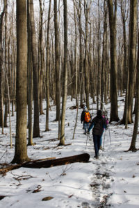 This Sunday, we will hike the Finger Lakes Trail (FLT) starting at the Mt. Morris Dam and Visitors Center Parking Lot. We expect to enjoy the height of winter as we follow the east rim of the Letch worth … Continue reading | ||||||
| Winter Hike, Ski or Snowshoe – All Western Evergreen Farm, Springwater 2:00 pm Winter Hike, Ski or Snowshoe – All Western Evergreen Farm, Springwater @ Liberty Pole Road Mar 9 @ 2:00 pm – 4:00 pm 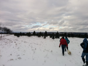 You are invited to hike, ski or snowshoe on a very special private property near the Northwestern corner of Springwater on the 248 acre All Western Evergreen Nursery & Christmas Tree Farm! Note, this hike was rescheduled from 2/16/25 date which … Continue reading | ||||||
| Hike at Sandy Bottom Park, Honeoye 2:00 pm Hike at Sandy Bottom Park, Honeoye Mar 16 @ 2:00 pm – 4:00 pm 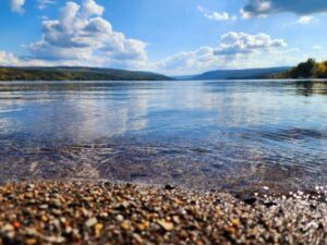 Our hike this Sunday, March 16th will be at Sandy Bottom Nature Trail starting from Main Street across the street from Birdhouse Brewery (8716 Main Street Honeoye, NY 14471). This is where we will park and gather. The hike will … Continue reading | ||||||
| Canadice Westside Trail Hike, Canadice 2:00 pm Canadice Westside Trail Hike, Canadice Mar 23 @ 2:00 pm – 4:00 pm 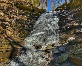 This week’s hike will be on Canadice Lake Trail! This is an easy, 1.8-mile each way hike along the shore of the lake; the trail is level and well-maintained and the lake views are lovely. For most hikers it will … Continue reading | ||||||
| Hike at Affolter’s Farm, Hemlock 2:00 pm Hike at Affolter’s Farm, Hemlock Mar 30 @ 2:00 pm – 4:00 pm More details about this very special hike coming soon! Please check back. |
This Sunday we will return to the Genesee Valley Greenway (GVG) for a bike or hike on a section of the trail that is farther north than we have hiked in the past. We will meet close to the northern border of Livingston County with Monroe County.
Notice:
The Hometown Event published in Friday’s PennySaver was a week early. This Sunday we will be hiking the Greenway. Join us next week, October 8th, 2023, for a hike on Rob’s Trail in Hemlock.
 All hikers and bikers will meet at 1:45 (for a 2:00 start) at the Lehigh Valley Trail parking area on West River Rd between Avon and Scottsville. This parking area is across the street from the Livingston Office Park located at 96 W River Rd and just a few feet north of the River Road Transfer Station driveway..
The Tourist/Climber hikers who would like a three mile or more flat hike will carpool 2.4 miles north to Canawaugus Park in Scottsville. From that parking area, we will find the GVG at the east end of the parking area and turn right to head back south to the Wadsworth Junction with the Lehigh Valley Trail. A left turn will take us across the Genesee River. Based on available time, the group will hike as far as time permits along the Lehigh Valley Trail timing things to return to the GVG at about 3:45, allowing 15 minutes for the final half mile on the Lehigh Valley Trail back to the cars.
Meanwhile, the Naturalists and any other hikers who would prefer an out and back hike will follow the Lehigh Valley Trail east to the GVG at the Wadsworth Junction. From there, we will head north of the GVG. After an hour (or when we meet the Tourist/Climbers group), we will turn around and return to the cars.
Finally, the bikers (who should arrive around 1:45 to unload their bikes) will head east on the Lehigh Valley Trail. At the Wadsworth Junction, we will turn left onto the GVG and ride north through the Canawaugus Park. We will regroup at the NY-253 crossing to evaluate our route back to the cars. The map above shows a route east on 253 for a mile to a right turn into Harrogate Crossing. We will explore the neighborhood (turn left on Longton Pl, left on Westcombe Park and right on Martin Rd) to get to East River Rd. We will pass the New York Museum of Transportation and continue past NY 251 until we come to the Lehigh Valley Trail. From there it is 2 miles to the cars for a total ride of 11 miles. My pre-ride took 1 1/4 hours (an average of 9.2 mph). I expect we will spend a bit more time enjoying the scenery.
This trail is currently in excellent condition. The initial segment of the Lehigh Valley Trail has some erosion as it slopes down. Bikers should take this slowly to avoid getting caught in the erosion. The main Greenway headed north is crushed stone which is very smooth. Occasional walnuts on the trail and stop signs at tractor crossing will keep bikers alert. The bikers will ride on NY-253 with wide shoulders and E River Rd with good shoulders until we cross NY 251. There is one railroad crossing on 253 where all bikers will want to cross perpendicular to the tracks. The more narrow shoulders on E River Rd after 251 will require us to share the lane with the occasional car. Finally, the Lehigh Valley Trail from E River Rd to the Wadsworth Junction is level dirt, only slightly rougher than the crushed stone.
Social: Following the ride and hike, we will gather for a social at the Mortalis Brewing Company.
Directions to the trailhead:
From Springwater: Take NY-15A north to Lima. Turn left on 5 & 20. You will cross I-390, and NY-15, go around the circle in Avon, and cross the Genesee River. Stay straight on NY-5 when US-20 turns to the left. You will cross the Greenway and then turn right onto CR 84 (W River Rd). In 4.3 miles, the parking area will be on the right.
Alternatively from Springwater: Take NY-15 north for 22 miles through Livonia and Lakeville. Turn left onto 5&20, staying on NY-5 when US-20 turns left after Avon. You will cross the Greenway and then turn right onto CR 84 (W River Rd). In 4.3 miles, the parking area will be on the right.
From Dansville: Take I-390 north for 29 miles to exit 10. Turn left onto 5&20, staying on NY-5 when US-20 turns left after Avon. You will cross the Greenway and then turn right onto CR 84 (W River Rd). In 4.3 miles, the parking area will be on the right.
From Naples: Take CR 36 north for 14 miles to Honeoye. Turn left on US-20A for 4.8 miles Hemlock. Turn north on NY-15A to Lima. Turn left onto 5&20, staying on NY-5 when US-20 turns left after Avon. You will cross the Greenway and then turn right onto CR 84 (W River Rd). In 4.3 miles, the parking area will be on the right.
From Canandaigua: Take 5&20 west for 25 miles, staying on NY-5 when US-20 turns left after Avon. You will cross the Greenway and then turn right onto CR 84 (W River Rd). In 4.3 miles, the parking area will be on the right. (Google maps says you can save 2 minutes by going north and taking the Thruway).
Notice: Sunday, Oct 8, 2023: The weather forecast seems to be consistently predicting rain and wind peaking at 3:00. So, check for updates before you head out today. We will hike if there is no lightning and there are hikers dressed for rain, but hikes may get shortened based on the weather. Also note the change to the social below. If you don’t come today, we will be at the the Folk Art Guild in Middlesex next week if the weather improves. Also note the change to the social below.
Rob’s Trail offers a peak opportunity for Finger Lakes hiking – a delightful woods walk from one Finger Lake to another. The full 8-mile walk is longer than our usual SWT event, so we’re planning separate start times and places for those wishing to do the full lake-to-lake distance, with shorter and easier hikes available to the Tourist and Naturalist groups.
For Climbers – lake to lake hike: meet at 12:45 for 1PM start at the Hemlock Lake north boat launch. 42.742059, -77.608443 We will hike for about 2.5 miles along the Hemlock lake shore, then climb to the Route 15A crossing and over the ridge on the loop trail, with a snack and rest break at the mid-point. We will descend on the Canadice side of Rob’s Trail and return to the Purcell Hill Road trailhead for carpooling back to the start. Estimated time is 3.25 hours. If you are seeking a possible bail-out in the middle, contact Saralinda through Comments section and we can arrange for an escape plan at Route 15A. Poles and rain gear are recommended, as showers are predicted and the ground will be slippery from earlier rains.
For Tourists and Naturalists – Canadice Lake Trail and Rob’s Trail to the Loop: meet at 1:45 at Purcell Hill Road trailhead for 2PM start. 42.743197, -77.574363 Tourists will hike 1.75 miles to the Rob’s Trail intersection and up to the ridge, around the loop trail, and back to the start the same way. Total distance about 4 miles with some moderately steep sections. Poles and rain gear are recommended, as showers are predicted and the ground may be slippery from earlier rains. Naturalists will follow along with the Tourists until the Rob’s Trail intersection, but remain along the Canadice Lake Trail as far as you want and return. All relatively level terrain, good wide trail surface.
Social – Join us for refreshments afterwards at the Valley Inn, 8790 Main Street, Honeoye (corner of Route 20A and County Road 37.
Directions – to Hemlock Lake North Boat Launch (for Climbers only, at 12:45 PM) – From Springwater: proceed north on Route 15A 19 miles, then make a left on Rix Hill Road and an immediate left on Old East Lake Road, a.k.a Boat Launch Road. From Honeoye and points east: Take Route 20A west from the Bristol Valley and Honeoye. When 20A meets Route 15A, make a left and go about .6 miles to Rix Hill Road. Make a right and then an immediate left on the boat launch road. From Rochester and points west: Take Route 15 south from Henrietta or Route 15A south from Honeoye Falls, or Route 390 south to the Lakeville-Livonia exit, then go south on Route 15 and then east on Route 20A through Hemlock. When Route 20A turns east toward Honeoye, go straight another .6 miles and make a right on Rix Hill Road. Then make an immediate left onto the boat launch road and go to the end, 1 mile.
Directions – to Canadice Lake Trail (for Tourists and Naturalists, at 1:45PM) From north: Route 20 between Honeoye and Hemlock, go south on Canadice Lake Road and west on Purcell Hill Road. The Canadice Lake Trailhead will be on your left. From south: From Springwater, go north on Route 15A to Johnson Road, make a right and then a left on Canadice Lake Road. Pass the lake and make a left on Purcell Hill Road. The trailhead parking area will be on your left.
Directions to Valley Inn for Social – From Purcell Hill Road, return to Canadice Lake Road and go north to Route 20A and east toward Honeoye. The Valley Inn is on your left at the intersection with County Road 37.
Sunday October15 we will visit East Hill Farm, home of the Rochester Folk Art Guild, to enjoy their annual Apple Festival and a hike across their 350-acre hilltop farm and woodlot. The Guild is a community of craftspeople, producing fine quality handmade products in wood, pottery, fabrics, paper, toys, books and more. We will have an opportunity to visit their artisan workshops and Gallery Shop before or after the hike – for more information about the Guild and the Festival see
https://www.folkartguild.org/events/open-house-and-apple-festival/
Please arrive by 1:45 for hiking starting at 2 PM. Park on the road shoulder at 1445 Upper Hill Road, Middlesex (directions below). We will convene at the side of the East Hill Gallery, the first building on the left as you come in the driveway.
Climbers will head south through the Guild’s farm and neighboring properties, past a pond and sauna, through a spruce grove, and looping through woods and mowed fields to the Golden Valley, named for its spectacular fall color and views to the east across Italy Valley. We will return through the woods and pass an eclectic array of residential buildings, workplaces and gathering places, designed and built by community members over their 50 years of occupancy at the East Hill Farm. Total distance is about 3.5 miles. Tourists and Naturalists will make a shorter loop of about 2 miles. Trails are gently sloped and well cleared. As a hunting season precaution, please bring some bright colored outerwear, along with water, poles and dampproof boots. With showers possible, good rain gear is also advised (as we learned last Sunday).
Social: We will convene after the hike for a bring-your-own social on the grounds of the Guild’s main farmhouse, or inside. Homemade cider, local apples, lunch dishes and desserts will be on sale throughout the festival (11-5) or until everything runs out.
Directions: from Springwater/Naples: Take Route 15 south to Wayland and Route 21 east/north to Naples. Turn right on Route 245 opposite Bob’s and Ruth’s Restaurant, at the north end of the village. Follow Route 245 north to Middlesex, about 8.75 miles. Turn right on Route 364 and go up the hill, one mile. Turn right on Upper Hill Road and go 1.5 miles. East Hill Farm will be on your left, at #1445. Park on the road shoulder and walk in the driveway to the Gallery building, the white house on your left.
From points north: Head to Routes 5 and 20 via Bloomfield or Canandaigua. At the east edge of the City of Canandaigua (first light after Wegmans/Post Office), turn south on Route NYS Route 364 (a.k.a. East Lake Road). Follow Route 364 south 12.5 miles to Middlesex, where 364 turns to the east and you will make a left onto Route 245 and then an immediate right to continue on 364. Go up the hill, one mile. Turn right on Upper Hill Road and go 1.5 miles. East Hill Farm will be on your left, at #1445. Park on the road shoulder and walk in the driveway to the Gallery building, the white house on your left.
The Sunday hike on October 22nd 2023 we will walk the FLT on Hatch Hill in Naples; the Fall colors should still be strong for this hike. The hike will start at the Bob North bridge at the bottom of Ontario Street in Naples. There is a kiosk and a small parking lot there, and all groups will start at the same place. The Naturalists will walk along Matt’s Meander to the Naples Community Park and back, while the Tourist will walk south along Hatch Hill above the town to the south end of Naples. The Climbers will walk north on Hatch Hill to Conklin Gully. Both Tourists and Naturalists will walk back to the parking lot, while climbers will end up at the DEC parking area at the bottom of Conklin Gully and be shuttled back to Naples. Note: the last half mile of this hike is a very steep downhill, but it’s worth it; there are huge drops into the gully to the right of the trail, and wonderful view across the gully and down into it.
There is a DEC display board at the parking lot with a map of all the trails that meet there; all the day’s hiking trails are shown.
Naturalists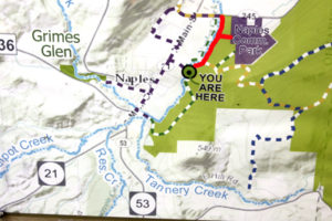

The Naturalists will cross Naples Creek on the Bob North bridge and bear to the left. It is a broad path through woods with the Naples Creek flowing to the left of the path. This trail is called “Matt’s Meander”, and it follows Naples Creek to the Community Park on Route 245. It is about a mile to the end of the trail and back.
Tourists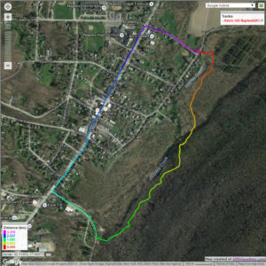

The tourists will cross the bridge and bear to the right. The trail runs south along Hatch Hill above Naples Creek, and goes parallel to both Naples Creek and Naples Main Street, though a lot higher up the hill. This path is not blazed or marked at all but it is well trodden for most of the way; it becomes a little harder to see at the southern end, but once the Turkey Federation parking lot is in sight then it’s not hard to find a way down to it. The trail passes through land that was once grazed and then terraced for vines, but is now returning to woodland. Traces of the shallow terracing for the vineyards can be seen all along the trail, and occasionally an abandoned farm building. The creek can be seen in the valley below the trail all the way along. This trail ends at the south end of Naples, on Mark Circle, where several streams come together to form the Naples Creek. There is water supply facility there, a swimming hole, and an antiques shop. The group will return to the Ontario Street parking lot via Naples Main Street. This walk is 2.1 miles. with just one short modestly steep section.
Climbers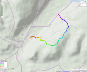
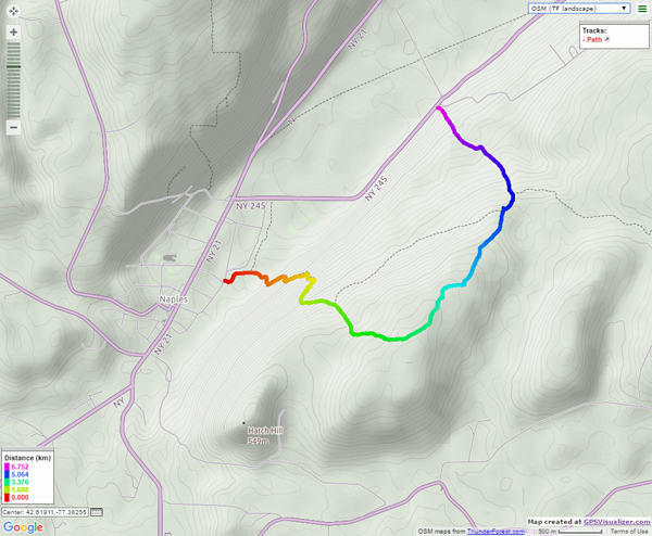
The Climbers will take the Finger Lakes Trail to Conklin Gully through the High Tor Game Management Area. They will cross the bridge and bear left along with the naturalists, and then about half way down Matt’s Meander the FLT branches off to the right. The group will follow the ORANGE blazes on a long uphill section; it’s steep in places with some switchbacks – the trail seems to be going the wrong way at times. There are some ponds at the top of the hill (it’s a mystery – where does that water come from?) with the Howard Beye memorial bench on one of them. It’s important to stay with the orange blazes here – there are several logging roads that make it easy to take the wrong path. Where the trail meets the top of Conklin Gully there is a lookout with a fine view of the Naples Valley and a well organized scout camp, complete with fire pit. The path down the hill from the camp is broad and easy walking. The group will leave the FLT where it branches off to the right over a bridge to the memory of Tom Noteware and follow the BLUE blazes down the hill to the DEC parking lot at the bottom of Parrish Hill.
The Meeting Place
We will meet at the trail head parking lot on Ontario Street, Naples, at 2:00pm. The climbers will shuttle some cars to Parrish Hill before starting off.
Getting There
From Springwater and Wayland, come south on Rt. 15 to the traffic light at Rt 21. Turn left on 21 and keep going all the way to Naples. Go through the downtown business area and turn right on Ontario Street, opposite the school. Go to the bottom of the hill and the parking lot is on the left.
From Dansville, follow Rt. 63 to Wayland where the road turns into Rt 21; continue on 21 all the way to Naples. Go through the downtown business area and turn right on Ontario Street, opposite the school. Go to the bottom of the hill and the parking lot is on the left.
From Naples, go to the school on Main Street (Rt. 21). Turn down Ontario Street opposite the school, go to the bottom of the hill and the parking lot is on the left.
The Social
The social will take place at the Middletown Tavern, 183 S main Street in Naples
.
Naturalists will head out on Bear Cub to the Chalet Trail. Chalet is an old road that once led to a large chalet and cabins which housed a camp at one time. Two of the old red cabins are still standing. This group will cross a few bridges, pass a pond, and make their way to the great scenic view Overlook. Then it’s a half mile hike up Overlook Rd to return to the starting point. Total mileage about 2.8 miles.
Social: Following the hike please join us for some food/drink at the Birdhouse Brewing Company, 8716 Main Street, Honeoye .
We will explore the Red and Green Trails. Please wear Blaze Orange if you have it or another bright color.
Address: 6280 Gulick Road, Naples Entrance/Parking is North of Cumming Nature Center
From Finger Lakes Land Trust web site: (During the full hunting season, from October 1 – December 19, the majority of the preserve and hiking trails will remain open to the public, including the area of the preserve lying west of the cabin and to the overlook (at the yellow/blue trail junction, west of the orange/yellow trail junction). The yellow and blue trails accessed from Wesley Road will be closed to the public to allow for bow hunting in a section of the preserve.
Map of Wesley Hill Preserve – https://www.fllt.org/wp-content/uploads/2015/02/Preserve-Brochure-Wesley-3.pdf
The Social will be a potluck/dish to pass at Kelly’s home, 36 University Avenue, Atlanta. See directions below. Bring your our own beverage and a favorite dish to share, or contribute $5 to our social fund.
Directions to Wesley Hill Preserve, Gulick Road parking area:
From Honeoye: take route 20A east through Honeoye to East Lake Road (CR 33). Turn right onto East Lake Road. (If coming from Bristol or points east, it’s a left onto East Lake Road). Take the first left, staying on CR 33, then the first right onto Pinewood Hill which becomes Gulick Road. Travel about 5 miles to Wesley Hill Parking Area on the right side. Parking lot can fit about 16 vehicles; any late comers can park on the side of the road.
From Springwater: Head north on Rte. 15A toward Hemlock. Just before Hemlock, turn right on Rte. 20A. Follow Rt 20A to Honeoye and then follow the directions above.
From Naples: From the southern end of Naples, head west on Co Rd 36. Follow Co Rd 36 for 1.2 miles to the first right turn on Gulick Rd. Follow Gulick for about 7 miles, past Cumming Nature Center. The parking area is on the left.
Directions to Social: Leaving the parking lot on Gulick Rd, head South to Hunt Hollow Rd/County Rt 36. Turn Right onto Hunt Hollow Rd. Take a short distance to Maxfield Rd and turn left. Follow Maxfield to Eelpot Rd and turn Right. Follow Eelpot to Route 21 and turn Right. Follow 21 as if going to Wayland, making the right turn in N Cohocton at Mikey’s Mini Mart, then make your first left onto University Ave. The house is the 2nd home on the right past the Fire House. Please park on the street or in the left side yard via the dirt drive. Leave the gravel drive open as I’ll have everyone enter through the back door/mud room.
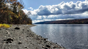
The water in Hemlock Lake is very low at the moment and a wide swathe of beach is exposed. We will take advantage of the unusual conditions to walk as much of beach as we can on this Sunday hike. The beach is generally 12-15 feet wide and varies between stony and rough stone chips. It will be a slow and careful walk but there’s plenty to see along the way and the lake and the late autumn woods on the opposite shore are very scenic. Wildflowers are scarce in November, but there are tiny pink and yellow flowers growing in the shelter of the stones.
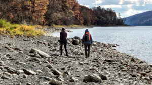
Meet at 1:45 at the north boat launch, south of the eastern edge of Hemlock Lake State Park. There’s a generous parking lot there and easy access down to the exposed beach. This is necessarily an out-and-back hike, so all groups will walk south together and anyone can turn around at any time. The beach follows the path of Rob’s Trail just a few feet away in the woods, and there are lots of places where walkers can switch between the beach and Rob’s Trail. All groups will walk south together and the naturalists and tourists can turn around whenever they feels it’s the right time.

The social will be a dish-to-pass picnic at Jane Affolter’s farmhouse at 5422 County Road 37
Directions: from Springwater: Head north on NY-15A. At the end of Hemlock Lake, turn left on Rix Hill Road. Almost immediately turn left on to Old East Lake Road, go past the Rochester City water treatment plant and continue on Old East Lake Road until you come to the boat launch parking lot.
Directions: from Canandaigua, Honeoye and points east: From Honeoye, continue west on Main Street (Route 21A) to Route 15A in Hemlock. Make a left, go a half mile, and take a right on Rix Hill Road. Almost immediately turn left on to Old East Lake Road, go past the Rochester City water treatment plant and continue on Old East Lake Road until you come to the boat launch parking lot.
Directions from north and west: Take Route 390 south to Exit 9 (Lakeville-Livonia). Go south on Route 15 into Livonia, the southeast on 20 A. Make a right after 3.9 miles on County Road 56 (Federal Road), then a left on Adams Road after .6 miles. Take the second right on Blank Road. In a mile, fork left at Rix Hill Road and almost immediately turn left on to Old East Lake Road, go past the Rochester City water treatment plant and continue on Old East Lake Road until you come to the boat launch parking lot.
Join us on Sunday Nov 19th for a Fairy decent hike. Everyone will meet at the Nature Center parking area at 27 Pond Road, Mendon at 1:45 for a 2PM start.
Naturalists will explore the Nature Trail and parts of Birdsong and Quaker Pond Trails. Birdsong and the Nature Trails are noted for feeding the chickadees from your palm so bring some birdseed and give it a try. This hike is a loop with a length of about 1.5miles with the option to add another 1/4mile loop towards the end.
Social afterwards at Flaherty’s Restaurant, 60 W. Main Street, Honeoye Falls.
Directions to Nature Center:
From Springwater: Head north on 15A for 21.6 miles through Hemlock and Lima. Take a right at the exit to Honeoye Falls. Stay on W Main St into the village where you will join NY 65 (1.9 mi). Continue straight onto NY 65 for 4.4 mi. (At 2 miles, you will go around a traffic circle. Stay on NY 65.) Turn right onto Pond Rd at the first park entrance. The Nature Center is just inside the entrance, on the right.
From Honeoye, take US 20A west and head north on CR 37 for 8.2 miles to W Bloomfield. Continue straight on NY 65 for about 3 miles, and make a right on Quaker Meeting House Road just before you come into Honeoye Falls. When Quaker Meeting House Road ends at Route 251 (Rush-Mendon Road), go left and then right on Route 65/Clover Street. The Pond Road entrance to the park is about 2 miles to the north, on the right. The Nature Center is just inside the entrance, on the right.
From Rochester: Exit I590 at Monroe Ave toward Pittsford. Turn right (south) onto NY 65 (Clover St). In about 6.7 you will come to the Canfield Road entrance to the park – this is not the one you want. Continue another 1.5 miles, then turn left onto Pond Rd, the second entrance into the park. The Nature Center is just inside the entrance, on the right.
Directions to Flaherty’s for Social: From Nature Center parking lot, go left to Clover Street (Route 65) and then left toward Honeoye Falls. Proceed about 5.5 miles to Honeoye Falls and through the center of the village. Flaherty’s will be on your left at #60 W. Main Street, which is Route 65.
Powder Mills Park, off Route 96 in the Town of Perinton, is one of Monroe County’s outstanding hunting-free hiking parks, with a nice group of wooded glacial ridges and lowlands on a 380 acre property with a fish hatchery and a ski hill. It has been a county park since 1930, after an interesting history as a gunpowder factory, and it’s a fine spot to work off some of those holiday desserts.
Meet at the Rand Lodge Parking Lot on Park Road at 1:45 for a 2 PM start. Warm layers, hiking poles and good boots are advised. The Climbers will follow a winding course (low ridges and lowlands) of about 4 miles through the park, both north and south of Woolston Road. The Tourist/Naturalist group will follow along with the Climbers for about 1.5 miles, then split off on Trillium Trail for a detour to the Fish Hatchery and back to the start, for a total of about 2.25 miles.
Please join us afterwards for our optional post-hike social at Panera Bread, 7651 Route 96, Victor.
Directions:
From Springwater: Head north on 15A and make a right on Kellogg Road to County Road 37. Continue on CR37 to West Bloomfield and continue straight when it becomes Route 65 (West Bloomfield Road). Continue past Route 251, and make a right on Smith Road. Continue past Route 64 and make a left on Mile Square Road, which becomes East Street. In 2.6 miles make a right on Park Road. The Rand Lodge parking area will be on your right.
Via 490: From Interstate 490 – take the Bushnell’s Basin exit. Go left on Route 96, pass the Garnsey Road light, and take a right on Park Road. Go past the Fish Hatchery and Corduroy Road, then take the first left into the Rand Lodge parking lot.
Post Hike Social: will be at Panera Bread, 7651 Route 96, Victor. Directions to Social: Go right from Rand Lodge lot onto Park Road, take a right at the end on Route 96. Follow Route 96 for 2.5 miles, past Eastview Mall. Panera Bread will be on your right, just before the light for Kohl’s and Walmart. If you miss the Panera driveway you can go right toward Hampton Inn at the light and then back across the parking lot to Panera Bread.
Looking for brochure.or mailing list so I can receive it in the mail.
Nothing opens up for mailing list.
There’s all kinds of very bizarre ads and post for viagra and other drugs above on calender page.
Please let me know if there’s a brochure available