
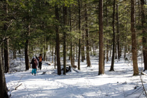
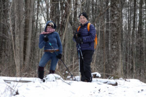
Hikes led by Springwater Trails are generally held on Sunday afternoons and appear in this calendar in green.
| Sun | Mon | Tue | Wed | Thu | Fri | Sat |
|---|---|---|---|---|---|---|
| Lehigh Valley Trail Hike or Bike in Rush, NY 2:00 pm Lehigh Valley Trail Hike or Bike in Rush, NY @ Stevens-Connor Lehigh Valley Lodge Apr 6 @ 2:00 pm – 4:00 pm Come join us for a leisurely hike or bike along the Lehigh Valley Trail on Sunday April 6th! With its flat even surface, the trail is a hidden gem for walking, hiking, jogging, biking. It is a vital link in … Continue reading | ||||||
| Ontario County Park at Gannett Hill Hike-Naples 2:00 pm Ontario County Park at Gannett Hill Hike-Naples @ Lookout Parking area Apr 13 @ 2:00 pm – 4:00 pm  This is one of our group’s favorite hikes! Ontario County Park at Gannett Hill is one of the highest points in Ontario County and located in the scenic Bristol Hills. At an elevation of 2,256 feet above sea level, you’ll … Continue reading | ||||||
| No Hike-Easter Break 2:00 pm No Hike-Easter Break Apr 20 @ 2:00 pm – 4:00 pm No hike has been scheduled for this date due to the Easter Holiday. Enjoy the break, spend time with loved ones and eat chocolate bunnies. This will give you something to burn off next week  | ||||||
| Hike Rob’s Trail – Hemlock Lake side 2:00 pm Hike Rob’s Trail – Hemlock Lake side Apr 27 @ 2:00 pm – 4:00 pm Join us on Sunday April 27th to hike the west side of Rob’s Trail, the DEC/Nature Conservancy property in the northeast corner of Hemlock Lake! Options are to hike out and back to the south along the trail from the … Continue reading |
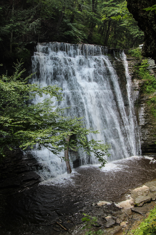
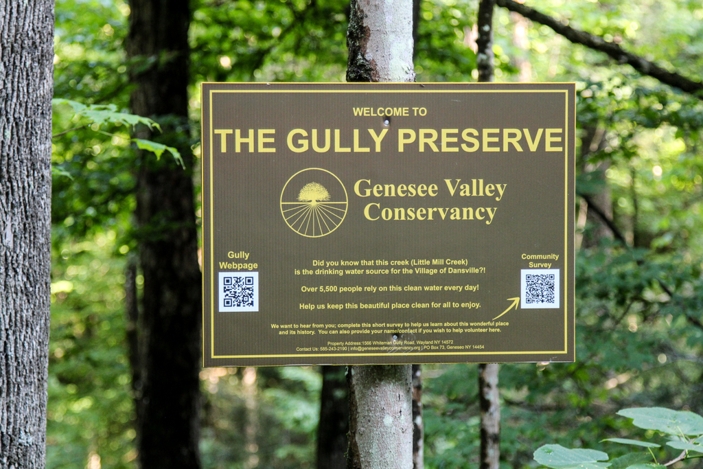
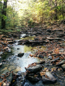
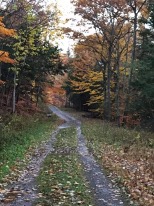
Whiteman Gully is a unique place – a pristine Finger Lakes gully untouched by any organized hand. It was privately held until recently, when it was bequeathed to the Genesee Valley Nature Conservancy.
This is a different hike to our usual long walk; it will be a hike of exploration along trails which are not long, but unimproved and requiring care. There are potentially 3 trails to explore, only one of which has been pre-hiked. The Conservancy web site speaks of “waterfalls” – plural – but only one has been seen so far. There have been no “improvements” to suit casual walkers on this property; if there has been rain recently the paths will be muddy but the waterfalls and the stream more impressive. To get a good view of the one waterfall that has been seen there is a stream crossing on stepping stones to be dealt with, and the section of the trail to get a view of the waterfall is short but steep; this pattern is likely to be repeated on other trails that we explore.
The gully does not appear to have been farmed or logged and the trees are big and old.
The Meeting Place
We will meet at the point where Whiteman Gully Road in Wayland crosses the stream of the gully (42.55731, -77.65159). There is adequate roadside parking on Whiteman Gully Road. First we will explore the trail to the north west and the gully around the waterfall. We will then return to the meeting point and explore the trail upstream and finally the trail the the north west on the opposite side of the stream to the first trail that we followed.
All hikers will walk in just one group on this hike, and hiking alone is definitely to be avoided given the uncertainty of the trail conditions.
Equipment
Gum boots or high waterproof boots and two walking poles are strongly recommended for the stream crossing, especially if there has been rain, and the poles are generally helpful on muddy and steep ground.
We will bring a rope to help on the steep section of the trail near the waterfall
Directions:
From Naples: Come into Wayland on Rt 21 from the east. Continue through the two traffic lights when the road becomes Rt. 63 to Dansville. Passing the the Wayland school on the left, continue for about 3 miles to Whiteman Gully Road on the right. Turn right and follow the road for about half a mile; the road turns into dirt and drops downhill; the gully is at the bottom of the hill where the stream is marked by barriers along the side of the bridge.
From Springwater: Come into Wayland on Rt 15 and turn west on to Rt. 21, then follow the directions as from Naples.
From Dansville: Drive towards Wayland on Rt 63 and take the second Whiteman Gully Road left – Whiteman Gully Road follows an arc with both ends on Rt. 63 – then follow the road for about half a mile. The road turns into dirt and drops downhill; the gully is at the bottom of the hill where the stream is marked by barriers along the side of the bridge.
The Social
The social will be at the Sunset Family Restaurant in Wayland, NY.
Next Sunday’s hike will take us to this Wildlife Management area run by the DEC Division of Fish and Wildlife for the purposes of conservation and recreation. A “tor” is by definition a hill or mound, therefore not much flatland for hikers. However, I have done my best to accommodate our 3 levels of hikers for this outing.
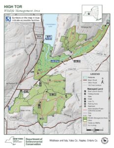
Meeting Place
Large parking area on Basset Rd. Naples. From Rt. 21 in Naples, heading south, bear left on Rt. 53.. In about .75 miles, turn left on County Rd. 21. aka Italy Valley Rd. Basset Rd is a left turn, about 2 miles east. The parking area is on the left, about .5 miles down.
Hiking Groups
All hikes are on shaded gravel forest roads which lead from the same point in the parking area.
Naturalists and Tourists will head north on the gravel road, soon passing through a gate. They will bear left and pass by two nice ponds, then head uphill on a gradual grade through the woods. The Naturalists can choose to turn around and return to the start at any point, as needed. After about 1 mile another gate is reached and the Orange Bristol Hills Branch of the FLT appears ahead, still on the gravel road. In about .5 miles the orange trail veers left into the woods, but hikers continue straight ahead on the truck trail. In a short distance the DEC lean to and overlook towards Canandaigua Lake appears. Unfortunately the view is limited by trees, but it is a good place to sit and rest for a bit. The return route is back down the same road for a total of 3 miles.
Climbers will take the road to the right after the gate and begin to ascend through the woods for about 1 mile. Eventually the road levels out quite nicely. Another gate is reached at which point the group will turn left and enjoy a nice downhill for about 1 mile to a lovely pond on the right. There is path along the shore if a closer look is desired. The gravel road continues uphill straight ahead to a gate at the intersection with the Orange trail. A right turn on the Orange trail followed by a straight ahead on the DEC road will bring the group to the lean to and overlook. Return route will be down hill via the gravel truck trail back to the parking area. Total trip is about 5 miles.
Social
Following the hike we will meet at Middletown Tavern on the corner of Main Street (Rt 21) and Clark St. (Co.Rd 36).
A hike through the Mitchellsville Gorge.
The hike on Sunday 7th August 2022 will follow a section of the main path of the Finger Lakes Trail in Urbana, just south of Hammondsport. It’s an easy hike of about 3.5 miles, and it follows the rim of a deep gully cut by the Mitchellsville Creek. This section slopes gently downhill from north to south with just a few short steep sections. The northern two thirds passes through a dense hemlock wood, and the path is a soft bed of hemlock needles; there are views of the deep gully along the way. There are two ‘beauty spots’ along the route; about a third of the way from the top there’s a short side track that juts out over the gorge giving good views from a height, and about two thirds of the way down there is a pretty creek. Unfortunately, we can’t get too close to either spot; this section of the trail is on private land and we can’t wander off it. The gorge overlook is crumbling and is dangerous, and access to the creek is specifically denied by the land owner.
A hike through the Mitchellsville Gorge.
We will meet at the FLT trail head on Route 54 in Urbana, by the Pleasant Valley Inn (42.388729, -77.260357) at 4:00pm.
The Climbers will shuttle to the high point of the hike at FLT access point 5 on Mitchellsville Road (42.404269, -77.290893), and then walk down the FLT back to the meeting point.
The Tourists and Naturalists will start at the meeting point and walk up the trail. They will walk a short distance north on Rt. 88 (it is Hammondsport-Pleasant Valley Road) and then go left on the FLT through a vineyard. At the end of the vineyard the trail crosses a stream and then rises up through the gully to a pretty spot by the creek. There are no steep sections on this stretch. Those who want to can carry on up the trail can do so, but there are some short but more difficult sections to navigate.
The Social
We’ll have a social at the Pleasant Valley Inn, next to where we meet for the hike.
Directions
From Honeoye: Follow W Hollow Rd (County Road 36) to Naples. Turn Right at the Middletown Tavern on to Rt. 21 South, and then bear left on to NY-53 South. Continue for 17.1 miles through Prattsburg and then turn left to County Rd 13/Mitchellsville Rd in Wheeler. Continue along Mitchellsville Road until you see the white church in Mitchellsville and then turn left in front of the church on to County Road 89. Turn right when this road ends and follow this road (County Road 88) to its junction with route 54. The parking area and trail head is on the left.
From Naples: Take NY-21 South, and then bear left on to NY-53 South. Continue for 17.1 miles through Prattsburg and then turn left to County Rd 13/Mitchellsville Rd in Wheeler. Continue along Mitchellsville Road until you see the white church in Mitchellsville and then turn left in front of the church on to County Road 89. Turn right when this road ends and follow this road (County Road 88) to its junction with route 54. The parking area and trail head is on the left.
From Rochester: Take NY 15 south to the I-390, and then I-390 South to the NY 54 / Bath exit, then follow NY54 north to the Pleasant Valley Inn. The parking area and trail head is on the left.
From Springwater and Wayland: Take 390 South to the NY 54 / Bath exit, then follow NY54 north to the Pleasant Valley Inn. The parking area and trail head is on the left.
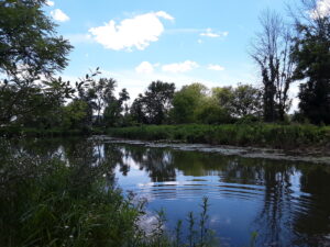
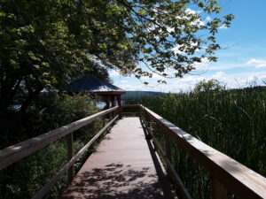
Please join us for kayaking on Sugar Creek and Keuka Lake or a hike through the marsh preserve to the lake. Our starting point will be the Finger Lakes Museum site, accessible from Guyanoga Road or from Route 54, both close to the flashing light at the center of Branchport. The Finger Lakes Museum is a former elementary school which is being gradually converted to a regional museum. They have an active boat launch site at the rear bordering Sugar Creek, the main tributary into the west branch of Keuka Lake; this kayak launch is difficult to use, so there is a choice of a beach launch across Rt. 54.
Kayakers should arrive by 3:40 to unload their boats and launch from the floating dock or from the nearby beach. Hikers, who will follow the trail along the river, and kayakers will leave at 4:00.
After launching, kayakers will head upstream in Sugar Creek through a woodland waterway. Based on time and conditions we then will turn around and head back past the dock to the lake. Once on the lake we will start heading west and enter the adjacent marshland owned by the Isaak Walton League. Cattails, water lilies and waterfowl are abundant in the marsh waterways. Back on the lake we will continue west to the marinas of Branchport. Another U-turn will take us toward Keuka Lake State Park. Finally, we will return to the river and up to the takeout at the Museum’s dock.
Hikers will hike to Keuka Lake along the museum paths, stopping at an observation platform overlooking the marsh and at the Museum’s lakefront pavilion.: After enjoying the lake views, we will return to the museum and explore the museum grounds.

Social: The social will be at the newly re-opened Blue Eagle, at the top of the hill on the road from Branchport to Prattsburg.
Directions:
From Springwater and Wayland – Take Route 15 south and then Route 21 north to Naples. Coming into Naples, go right on Route 53 toward Prattsburgh. In 1.2 miles make a left on Italy Valley Road. You will remain on Italy Valley Road for about 8.7 miles, although the county road number changes from 21 to 18 to 34 en route. At the end of Italy Valley Road, go left for .3 miles on Italy Hill Road (CR 35), then follow Itlaly Hill Road as it curves to the right and becomes CR32. In another 4.7 miles you will be at the flashing light in the center of Branchport. Go straight on Route 54A toward Penn Yan for .2 miles, and turn left into the Finger Lakes Museum across from the Library, and before the Fire Station. Look for the driveway toward the new barn on your right.
From Canandaigua and 5&20: Take East Lake Road south to County Road 1, or Route 247 from Reed’s Corners into Rushville. Continue South through Rushville toward Penn Yan. Route 247 will become Route 364 shortly before Potter. Continue for 4.5 miles past Potter and make a right on Guyanoga Road (CR 29). Go another 6.5 miles to Branchport. Turn left into the Finger Lakes Museum at 3369 Guyanoga Road, or if you miss it, go left at the flashing light and then left into the FLM drive. If you come in from Guyanoga Road, go to the right around the building and parking lot, and follow the signs to the Creekside Center (a new barn). Park on the grass near the boat rack. If you take the side entrance in from Route 54A heading east toward Penn Yan, turn in to the left, across from the library, and then right into the Creekside Center.
NOTE: As of Sunday morning, it looks like light rain much of this afternoon. The hike is still on, but the social will be at a restaurant. See you at 4:00.
This Sunday, we’re returning to Sonyea State Forest in Livingston County, to hike along the Keshequa Creek. Since the last time we hiked in this forest, the DEC has made some (minor) improvements, including designating 5 primitive camp sites. On our hike, we may find a campsite you will want to return to for a respite from the daily grind.
 We will meet at 4 PM at the gate that marks the head of the Keshequa Creek Falls Trail about 2.7 miles from the beginning of Union Corners Rd. See directions below. All hikers will walk around the gate to a well groomed trail the heads down a steep hill to the creek. Be careful walking down, and on the way back you will want to take your time climbing this hill. But the hill is not long and most of the rest of the trail is along the old Genesee Valley Canal and railroad bed. Our hike will take us to the western side of the forest, where we will encounter the gorge along Keshequa Creek. Within the gorge, we will see remains of the Genesee Canal and a major branch of the Pennsylvania Railroad, as well as rapids and falls along the creek.
The Naturalists will hike about a mile along the trail to a beautiful wide point in the creek where we can explore the falls and the intricate cracks in the rocks. After exploring that location, Katherine will lead the Naturalists back to the car the way we came.
The climbers will continue on the trail past the falls to the end of the trail, and then will return to the cars by way of the field to the entrance of the State Forest, and will walk on Union Corners Rd. If conditions or time require, we may adjust the route and return the way we came. Mark will lead the climbers..
After the hike, we will enjoy the August weather with a picnic in the woods. Bring a dish to pass, or make a donation. We will select a clear area so, bring folding chairs, and a table, if you have one. There are no washroom facilities, not even portable ones, but lots of trees If the day should turn out to be a rainy one, we will return to the Sunrise, in Dansville.
Directions: Please Note: Directions on Google Maps from Springwater takes you on NY 36 North to Craig Rd up through the Groveland Correctional Facility. This road is closed to cars, although walkers and bikers are allowed to use it as part of the Genesee Valley Greenway trail.. This is not a good way to get to our hike. Please follow the directions below.
From exit 6 on 390, turn south on NY 36. Then, take the first right onto CR 72, aka Presbyterian Rd. Follow it for 3.7 miles, bearing right at the intersection with CR 11, to Union Corners Rd. Turn right here and keep going for 2.7 miles,, till you see the gate. Union Corners Rd is unpaved, with potholes, making for slow going so, consider this in planning your travel time. Turn around at the gate and park on either side of the road.
From Springwater: Take NY 15 west from the flashing light. At the top of the hill (1.5 mi), turn left onto Liberty Pole Rd.(CR 38). Continue for 8.1 miles as the road number changes from CR 38 to CR 1A to CR 1. Turn left onto NY 63 S. In just 0.3 miles take the first right onto N 258. In 1.9 miles, continue straight across NY 36 and onto CR 72 (Presbyterian Rd). Follow the directions above to the state forest.
From Naples. Follow NY 21 S to Wayland. At the first light, turn left to stay on NY 21. In 1.8 miles south of Wayland, turn right on I-390 N. In 16 miles, take Exit 6. Turn right onto NY 36. Follow the directions above.
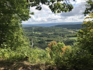
This Sunday we will hike the Finger Lakes Trail (FLT) starting at the Mt. Morris Dam and Visitors Center Parking Lot, as well as the Wildlife Loop Trail within the Dam property. We expect to stop periodically, as we follow the east rim of the Letchworth gorge, enjoying the spectacular views of the gorge and Genesee River below.
The Wildlife Loop trail within the dam property is beautiful in its own right, with forest and grassy fields.
Two levels of hiking are planned – “Climbers” and “Tourist/Naturalists” will both hike south on the yellow blazed (FLT) trail along the rim of the gorge, jogging east slightly away from the river across a boardwalk through a small wet area, stop at Hogsback Overlook to view the Hogsback formation of the river gorge, continue on the trail another .2 miles before turning around to head back. On the way back, we will follow the same yellow blazes but take the alternate orange blazed trail along the rim of the gorge which joins back up with the yellow trail, back to the parking lot. Total hike is 2.25 miles.
Once back to the parking lot, the “Climbers” who want a longer hike will follow the blue blazed Wildlife Loop Trail which begins just to the right of the Mt. Morris Dam Visitors Center, adding another 1.1 miles to the hike.
The Hike Assembly Point:
The Visitors Center will be closed. However, there is a bathroom adjacent to the parking lot that may be open on the day of the hike. All hikers will begin the hike at the Mt. Morris Dam Visitor Center Parking Lot. The trail access is at the west end of the parking lot (to your left as you face the gorge). While this trail is in a non-hunting area, it is recommended that you wear brightly colored clothing.
Social:
After the hike, all are welcome to gather at the larger pavilion located adjacent to the parking lot. Bring your own snack, drink, and chair (due to limited seating and need for social distancing).
Directions:
The Mt Morris Dam Visitor Center is about 45 minutes from Springwater, so please plan ahead. If you have a GPS, try entering Mt Morris Dam as your destination. Or enter Park Rd or Visitor Center Rd, Mt Morris.
From Springwater: Take Rt 15N and then left on Liberty Pole Rd. Stay on that road all the way to Rt63. There, take a left, and a quick right, onto Rt 258. At Rt 36, take a right and proceed to Mt. Morris. Turn left onto NY-408 South.
From Wayland: you can take I-390 north to exit 7. Turn left at the exit on NY-408 S to Mt. Morris. NY-408 goes left at Main St, then right on Chapel St.
From Hemlock and Honeoye: follow 20A West through Livonia and Lakeville to 390S. Exit at exit 7 NY 408 S to Mt Morris. Stay on 408 through Mt Morris.
From Rochester: Take I-390S to Exit 7 NY 408S. Stay on Rt 408 through Mt Morris.
From NY 408 in Mt Morris: Go south on 408 for 1.8 miles to Visitor Center Rd. Turn right at the Visitor Center Road and follow the road all the way to the Dam and Visitor Center Parking lot
East Hill Farm, home of the Rochester Folk Art Guild, is a community of craftspeople producing fine quality handmade products in wood, pottery, fabrics, paper, toys, books and more. On Sunday September 11th the Guild is graciously letting us pair a hike across their 350 acre hilltop farm with a presentation that is part of their summer Lecture on the Lawn Series. We will have an opportunity to visit their Gallery Shop in between the lecture and the hike.
LECTURE ON THE LAWN –
The lecture begins at 2PM and will be given by Dr. Bruce Gilman, Professor Emeritus of Environmental Conservation at Finger Lakes Community College. The title of his presentation is: The Local Landscape Then and Now: Glacial History, Early Forests and Current Ecological Communities. Briefly, the lecture will last approximately one hour, will be held rain or shine, and is free to the public but donations are appreciated. Bring a lawn chair. Details can be found at: https://www.folkartguild.org/lol/
HIKES –
Hikers will meet around 3:30PM in front of the East Hill Gallery (the first building as you come up the driveway). Climbers and Tourists will head south through the Guild’s farm and neighboring properties, past a pond and sauna, through a spruce grove, and looping through woods and mowed fields to a view looking east across Italy Valley. We will return through the woods and pass an eclectic array of residential building, workplaces and gathering places, designed and built by community members over their 50 years of occupancy at the East Hill Farm. Total distance is about 3.5 miles. Naturalists will follow a shorter route and go at a slower place taking time to observe late summer wildflowers. Trails are gently sloped.
SOCIAL –
Following the hikes, we will gather for pot luck on the lawn near the farmhouse or in the dining room if it is raining. People should bring a dish to pass (or make a donation to the social fund) and something to drink.
DIRECTIONS –
from Springwater/Naples: Take Route 15 south to Wayland and Route 21 east/north to Naples. Turn right on Route 245 opposite Bob and Ruth’s Restaurant, at the north end of the village. Follow Route 245 to Middlesex, about 8.75 miles. Turn right on Route 364 and go up the hill one mile. Turn right on Upper Hill Road and go 1.5 miles. East Hill Farm will be on your left at #1445. Park on the road shoulder and walk in the driveway.
from Rochester and points north: Head to Route 5&20 vial Bloomfield or Canandaigua. At the east edge of the City of Canandaigua (first light after Wegman’s/Post Office), turn south on Route NYS Route 364 (a,k.a. East Lake Road). Follow Route 364 south 12.5 miles to Middlesex, where 364 turns to the east and you will make a left onto Route 245 and then an immediate right to continue on 364. Go up the hill one mile. Turn right on Upper Hill Road and go 1.5 miles. East Hill Farm will be on your left #1445. Park onthe road shoulder and walk in the driveway.
Sunday September18th we will be hiking the trails around Camp Cutler, the scout camp between Gulick Road and Hunt Hollow Road (County Road 33) in Naples. Here’s the trail map: 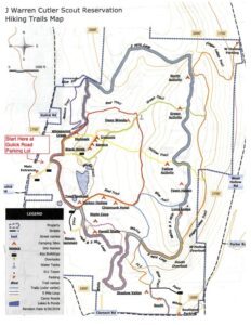
The hike – We will meet at 2:00pm at the shelter/pavilion at the edge of the large parking lot at 7131 Gulick Road. We’ll divide 2 groups, climbers, and tourists/naturalists. All groups will start off together, walking north from the parking lot. The trails are well marked with colored blazes and are easy to follow, but always look for the next blaze! Both groups will start out together following the camp roads.
At the first fork, stay to the left at the start of the red trail. A short distance up the hill, you will see a sign for the Nature Trail. Turn left off the road onto the blazed red trail. The Naturalists/tourists will follow the Red Trail which will loop around the pond for a total of 2.54-3 miles. The Climbers will complete a 5-mile loop around the perimeter of the camp. This hike does not disappoint, with two beautiful lookouts with spectacular views. We will avoid the areas of recent logging activity. Bring water and a snack for this long hike. There is a place to sit at each lookout. Poles are suggested; if it is wet, it may be slippery in spots.
The Social – After the hike, we will meet at the pavilion at the end of the parking lot for a social. Please bring a dish to pass and something to drink.
Directions: From Honeoye: take route 20A east through Honeoye to East Lake Road (CR 33). Turn right onto East Lake Road. (If coming from Bristol or points east, it’s a left onto East Lake Road). Take the first left, staying on CR 33, then the first right onto Pinewood Hill which becomes Gulick Road. Travel about 7 miles to Camp Cutler at 7131 on the left side. There is a big sign and a large parking area.
From Springwater: Head north on Rte. 15A toward Hemlock. Just before Hemlock, turn right on Rte.20A. Follow Rt 20A to Honeoye and then follow the directions above.
From Naples: From the southern end of Naples, head west on Co Rd 36. Follow Co Rd 36 for 1.2 to the first right turn on Gulick Rd. Follow Gulick for about 5 miles, the camp will be on the right. There will be a big sign and a large parking area.
PLEASE NOTE THE CHANGE IN HIKE START TIME TO 3PM.
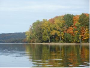
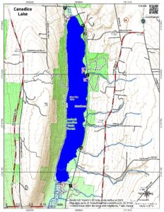
As the colors start to show, we can never get enough of our beautiful lakeside trails. This Sunday, September 25, 2022, we’ll be hiking the popular (and easy) Canadice Lake Trail, beginning at the north end. Flat-trail hikers can choose their distance from 1 to 8 miles. Most can choose a down and back, but if you prefer to do an end-to-end (about 4 miles), please arrive at 2:30pm to manage carpooling ahead of time. The north end parking lot is located on Purcell Road, Canadice, and the south end trailhead is located at 42.691653,-77.569149, about .6 miles south of the southernmost boat launch on Canadice Lake Road.
 There is also an option after about 2 miles in for the Climbers to veer off onto Rob’s Trail, for a trip to the top of the ridge, an additional distance of about 1 mile each way to the top. This portion leads over the ridge towards Hemlock Lake and does have some steep sections. The weather forecast currently shows a chance of rain, so if you plan to do Rob’s Trail, please be prepared for mud – hiking poles are recommended. All other hikers will enjoy a gentle sloping/flat trail. Leashed pets are always welcome.
Dish-to pass social: Following the hike, there will be a dish-to-pass supper at Denise’s house: 4950 S. Main St. (Rt. 15A), Hemlock NY 14466. Please bring a dish to share and something to drink. Homemade soup and brownies (both gluten free) will be provided by Denise.
Parking for up to ~7-8 cars is available, in the turn-around behind the house as well as to the right side of the driveway as you pull in. All others can park along the (busy) road in front of the house.
Directions to Purcell Hill Road Trailhead:
From Springwater: Head north on 15A and cut over to Canadice Lake Road. via Wheaton Hill or Johnson Hill Road. North of the lake, turn left on Purcell Hill Road. The parking lot will be on your left in about a quarter mile.
From Canandaigua, Honeoye and Hemlock: Take Route 20A to the Canadice Lake Road intersection. Go south 3.4 miles and turn right on Purcell Hill Road. The parking lot will be on your left in about a quarter mile.
From Rochester: Take Route 390 south to the 5&20 exit, go east to Lima, then south on Route 15A. After Hemlock, turn left on Route 20A and right on Canadice Lake Road. Go south 3.4 miles and turn right on Purcell Hill Road. The parking lot will be on your left in about a quarter mile.
Directions to Social: From north trailhead, go west on Purcell Hill Road to the end, the north on Route 15A about 2 miles to #4950.
Looking for brochure.or mailing list so I can receive it in the mail.
Nothing opens up for mailing list.
There’s all kinds of very bizarre ads and post for viagra and other drugs above on calender page.
Please let me know if there’s a brochure available