
Hikes led by Springwater Trails are generally held on Sunday afternoons and appear in this calendar in green.
| Sun | Mon | Tue | Wed | Thu | Fri | Sat |
|---|---|---|---|---|---|---|
| Lehigh Valley Trail Hike or Bike in Rush, NY 2:00 pm Lehigh Valley Trail Hike or Bike in Rush, NY @ Stevens-Connor Lehigh Valley Lodge Apr 6 @ 2:00 pm – 4:00 pm Come join us for a leisurely hike or bike along the Lehigh Valley Trail on Sunday April 6th! With its flat even surface, the trail is a hidden gem for walking, hiking, jogging, biking. It is a vital link in … Continue reading | ||||||
| Ontario County Park at Gannett Hill Hike-Naples 2:00 pm Ontario County Park at Gannett Hill Hike-Naples @ Lookout Parking area Apr 13 @ 2:00 pm – 4:00 pm  This is one of our group’s favorite hikes! Ontario County Park at Gannett Hill is one of the highest points in Ontario County and located in the scenic Bristol Hills. At an elevation of 2,256 feet above sea level, you’ll … Continue reading | ||||||
| No Hike-Easter Break 2:00 pm No Hike-Easter Break Apr 20 @ 2:00 pm – 4:00 pm No hike has been scheduled for this date due to the Easter Holiday. Enjoy the break, spend time with loved ones and eat chocolate bunnies. This will give you something to burn off next week  | ||||||
| Hike Rob’s Trail – Hemlock Lake side 2:00 pm Hike Rob’s Trail – Hemlock Lake side Apr 27 @ 2:00 pm – 4:00 pm Join us on Sunday April 27th to hike the west side of Rob’s Trail, the DEC/Nature Conservancy property in the northeast corner of Hemlock Lake! Options are to hike out and back to the south along the trail from the … Continue reading |
Please join us this warm and sunny fall Sunday to explore a new hiking site not far from Springwater. A few years ago New York State acquired several new parcels of land to the south of Harriet Hollister Spencer Park, linked to the main park by an established snowmobile trail called C4. Last August we hiked the section of the C4 trail closest to the main park, and this Sunday we will explore the rest of the C4 trail, going as far as Dutch Hollow Road and back. The hike will take us across a field with fine views toward Springwater and beyond, and through some little-traveled woods.
Meet at 1:45 PM at the intersection of Canadice Hill Road and Tibbals Road, a.k.a Townline Road (that’s the town line between Canadice and Springwater – also the Ontario-Livingston County Line). Park on the road shoulder. Total distance for Climbers is about 4 miles round trip. Tourists and Naturalists will follow the same route, but turn around after 45 minutes for a total hike of 1.5 hours and about 2.5 miles.
Wear something orange or otherwise conspicuous in case of bow hunters. As always, bring water, good hiking footwear and poles if you typically use them. The trail is gently rolling – no especially steep sections.
Social: After the hike we will repair to Birdhouse Brewing Company at 8716 Main Street, Honeoye. Sunday afternoon promises to be warm enough for us to be seated on the deck or in the tent. See https://birdhousebrewing.beer/index.php/about/ for their menu of craft beers and food.
Directions:
From Springwater and Wayland – take Route 15A North from Springwater, turning right on Wheaton Hill Road. Take a left on Canadice Road (County Road 42), forking to the right when County Road 42 divides off from Canadice Lake Road. Make the next right, on Tibbals Road (formerly Town Line Road). The trail head is where Tibbals Road ends at Canadice Hill Road/Wetmore Road.
From Rochester or Canandaigua – go to Honeoye, and follow Route 21A (Main St. Honeoye) west toward Hemlock. About a mile out of Honeoye turn left on County Road 37. Follow County Road 37 until it makes a 90 degrees turn to the right across from the Canadice Methodist Church; at this point go straight onto Canadice Hill Road instead of County Road 37. Continue straight on Canadice Hill Road, taking the left fork at Ross Road, and passing the main entrance to HH Spencer Park. The trail head is 1.7 miles south of the main park entrance, and 8.5 miles from Route 21A. Beyond the trailhead Canadice Hill Road turns into Wetmore Road.
Directions from Hike to Social at Birdhouse Brewing Co.
-
Take Canadice Hill Rd. going toward Harriet Hollister Parking Lot. Keep going straight, it will become County Rd. 37.
-
When you come to Route 20A you will make a right. (at the intersection, St. Mary’s Catholic Church will be on the Right corner). Take 20A into Honeoye.
-
Birdhouse Brewing will be a brown building on your left, four buildings past the traffic light.
On Sundays they serve Hot Dogs and Hamburgers and are open until 7:00pm.
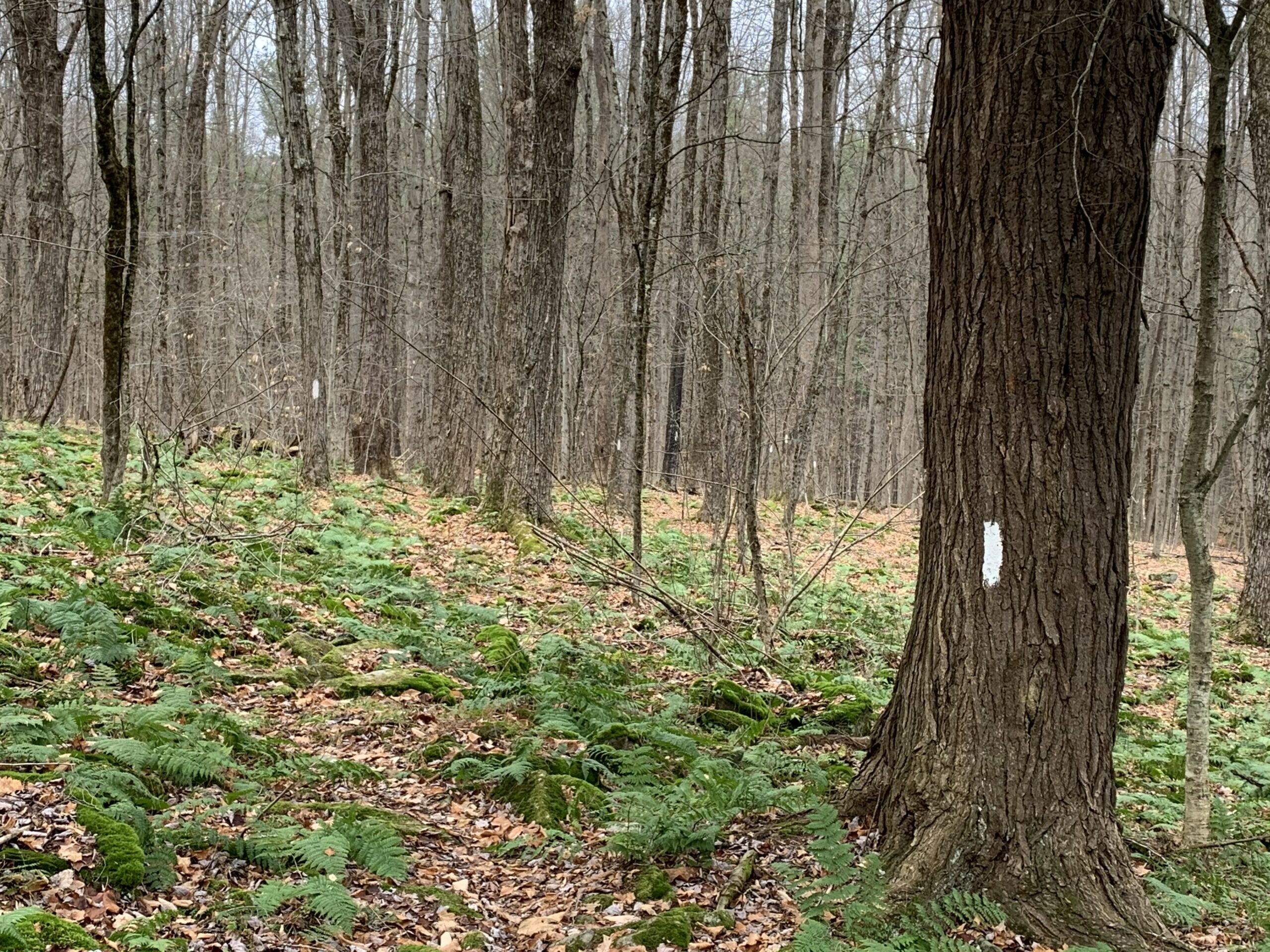
The trail is well blazed, but otherwise hard to distinguish from the rest of the forest.
Last month we hiked the Finger Lakes Trail in Bully Hill State Forest on a blanket of newly fallen fall foliage and enjoyed the beautiful colors. This month we are moving north to the Klipnocky State Forest, but all the leaves have lost their colors. Yet, the forest is still interesting and it is fun to be able to see through the trees to the ridges across the valley..
Note: Bow season is open, so an orange vest and hat are recommended.
Our hike will be an out and back, partly to avoid car pooling during COVID and partly because the roads inside the state forest aren’t great on you car. All hikers will meet at the end of Klipnocky Rd where it connects to Bill Morris Rd and Roots Rd. These roads inside the state forest are seasonal and not real good. Good clearance on your car is recommended.We should be able to park along Bill Morris Rd.

FLT Register at the stream crossing.
We will head west on Roots Rd to where the trail enters the forest on the left side of the road. The trail goes down to a creek and a register. The trail then has a slow climb along a well blazed trail to a dirt road. At this point the Naturalists can turn right and follow the road back to the cars. The Climbers will continue across the road for 3/4 of a mile where the trail starts down the remnants of an old road that becomes Gas Springs Rd in a half mile. This is a good spot to turn around because the old road is quite rough for walking. When we get back to the real road, the Climbers can either turn right and follow the road to the cars, or continue straight across the way they came.
Following our hike, we will have a simple social by the pond at our parking area. Please bring a sandwich or snack, and a beverage for you and your family. Also, bring a chair if you would like to rest!
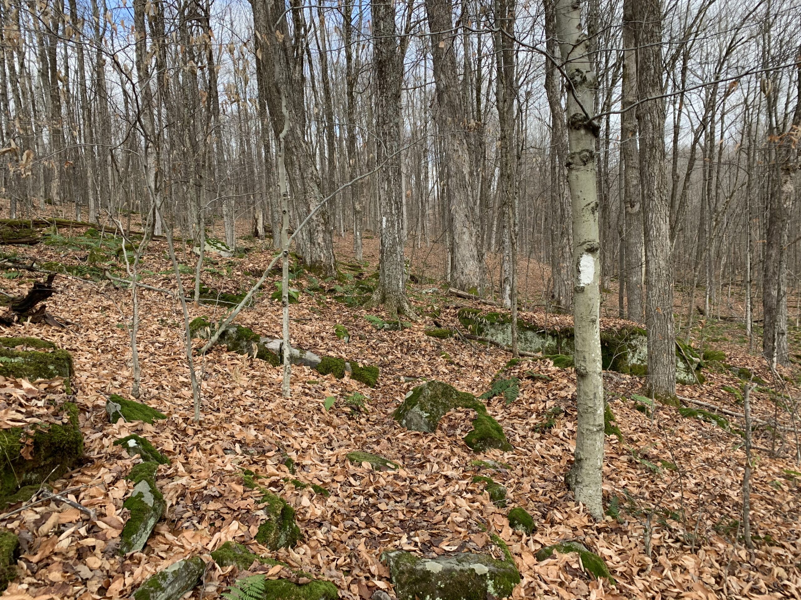
How many blazes can you see?
Please note that this trail is rocky, so you will find yourself watching your feet most of the time. Stop occasionally to look around and see the forest. Also, watch the blazes to stay on the trail.
Directions:
Since many hikers have never been to Klipnocky State Forest in Almond, NY, we will offer a caravan option from the parking lot behind the Firehall in Wayland. Plan to meet at the parking lot at 1:00. We will leave promptly at 1:10. Because of COVID, we are not encouraging carpooling, but we can follow one another.
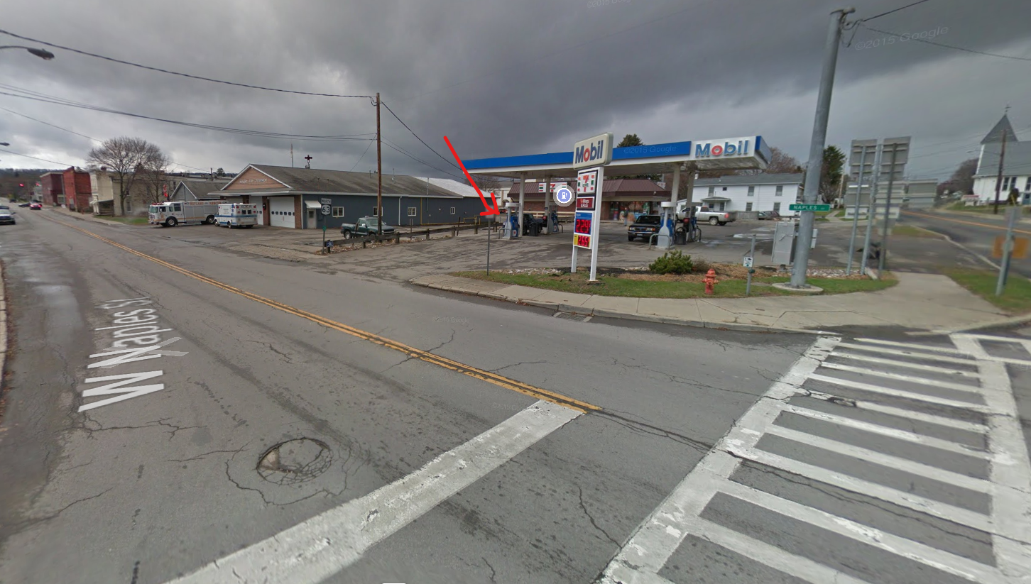 Meeting location in Wayland: From the intersection of NY 15, NY 21 and NY 63 in Wayland, head west on NY 63. At the Firehall, turn right the gas station and the Firehall to the public parking lot behind the firehall. From N Main St, you can enter the parking lot along the north side of the Belt in the Eye Diner.
From Wayland and Dansville: Head west on NY 63 from Wayland to Dansville. Turn left onto Clara Barton St (NY-36S). Continue on NY-36 for 7 miles to the light in Arkport. Turn right on West Ave. after the railroad tracks, turn left on CR 67 (Bishopville Rd), which becomes CR 32 in Allegany Co. In 2.9 miles from Arkport, Bishopville Rd will turn left, but you should continue straight on CR 32. In another 1.8 miles, turn right on Brown Rd. At the end turn left on Klipnocky Rd. At the tee, turn right. Park near the next intersection,
Please note this hike will begin at 1:30, as the Park closes at 4:00.
This Sunday’s hike will introduce us to new territory. Abe Lincoln Park is 182 acres of lovely trees, located along the southeastern shore of Irondequoit Bay, in the town of Penfield. It is an oasis nestled within a bustling commercial and residential area. The trails meander through several small glens or gullies and in places afford lovely views of the bay with its resident swans. It is a very popular destination for families, as there are several play areas for children in the front area. The hiking trails extend into the woods beyond the playgrounds. The parking area on Empire Blvd is small, 20 vehicle capacity. There is another parking area at the north end,]. If needed we could relocate the start of the hike to there. The trails are rocky in places with some steep sections. Sturdy hiking shoes/boots and poles are advised.
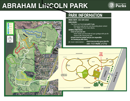 All hikers will begin from the same point of the main trail (white trail) which is well blazed. Depending on the number of folks and ability levels, we will branch out from this trail onto some of the secondary trails. Trail maps will be provided to the leader of each group. Naturalists will want to take a slower pace on a shorter route out to the edge of the bay on the Green Trail, less than 2 miles. Tourists may decide to go the length of the White Trail, at a slower pace than the climbers, 3miles. Climbers will go the full length of the White Trail plus explore some of the Red and Orange Trails, about 4 miles.
Social For those who wish to gather in the parking area after the hike, please bring your own snacks and beverages. Social distancing will be observed and masks should be worn.
Directions Follow 590N to the Empire Blvd exit. Go east on Empire Blvd., pass Irondequoit Bay then uphill to Abraham Lincoln Park on the Left near Daytona St.
Powder Mills Park, off Route 96 in the Town of Perinton, is one of Monroe County’s outstanding hiking parks, matching Mendon Ponds Park for rugged terrain and interesting features. Being inhospitable to farming or development, it was the site of a gunpowder factory in the 19th century, and some vestiges of this history survive, along with stories of some dramatic explosions. The 380 acre property has been a county park since 1930, and features a fish hatchery and a downhill ski area.
Meet at the Wadhams Lodge Parking Lot at 1:50 for a 2 PM start. Warm layers, hiking poles, water and good boots are advised. Hunting is not permitted in the park, so no need for orange outerwear. The Climbers will follow a winding course of about 4 miles of linked trails through the central and east parts of the park, both north and south of Woolston Road. The Tourists and Naturalists will join the Climbers for the first half of their hike, but will make a looped return to Wadhams Lodge after the halfway point, avoiding the most strenuous part of the hike and going about 2.5 to 3 miles.
Afterwards please join us for an outdoor social at the Wadhams Lodge. The Lodge has sheltered picnic tables on a porch and some open grills where we can make a fire to toast our hands at least, if the temperatures warrant it. Bring your own beverage and snacks – hot soup in a thermos will hit the spot, as it will likely be in the 40s. If you have a leftover bag of charcoal, bring that too. We will have some options for food delivery to Wadhams Lodge after the hike (most likely Pizza). More details on this later.
Directions:
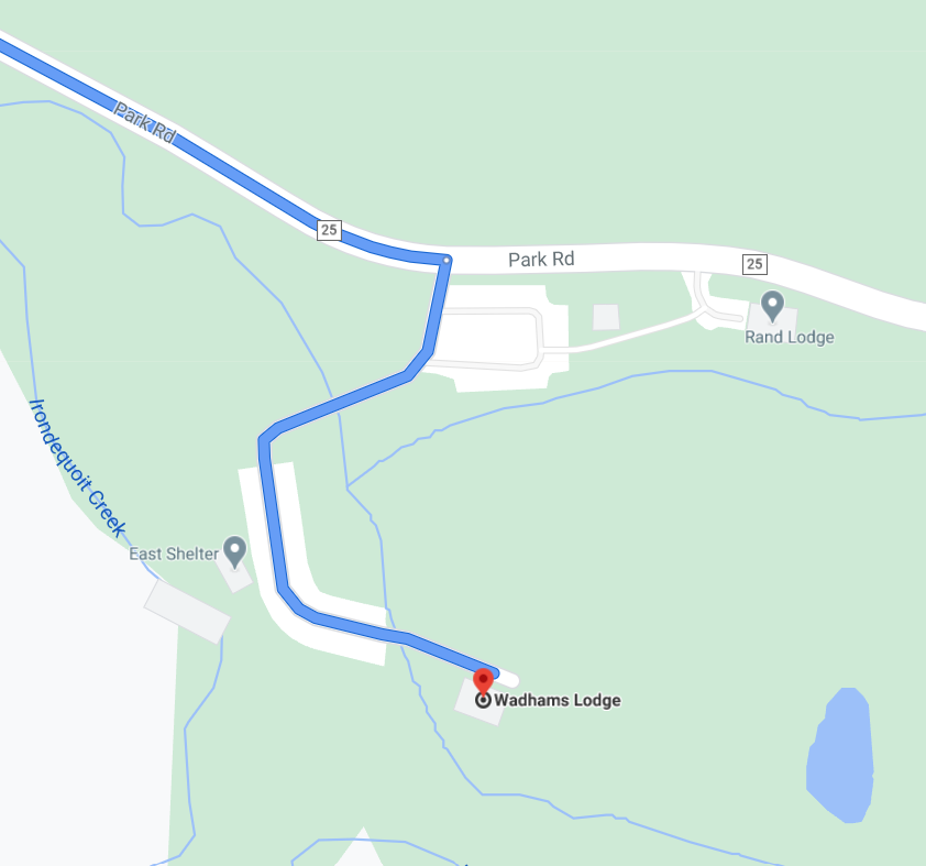 From Springwater: Head north on 15A for 21.6 miles through Hemlock and Lima. Take a right at the exit to Honeoye Falls. Stay on W Main St into the village , and at the center of town continue straight on Route 65 north. From Honeoye Falls go north 3 miles to the intersection with Route 251 and take a right (east). Continue east on Route 251 for 1.75 miles and make a left on West Bloomfield Road. After 4 miles and crossing the Thruway, make a right on Thornell Road, then in 1.75 miles a right on East Street and a left on Park Road (the third left). Go about another 0.8 mile into the Park, past several parking areas on the left, and turn in to the Wadhams Lodge parking lot on the right. Bear right and go all the way to the building at the end. If you come to the Fish Hatchery and Corduroy Road intersection on Park Rad, you have gone too far.
From Honeoye: Go west from the center of Honeoye, and turn north on CR 37. In West Bloomfield, continue straight onto NY 65. On the other side of W Bloomfield, continue straight onto CR 38 (NY 65 turns left). In 9.8 miles, turn right on Thornell Road. In 1.76 miles turn right at the 4-way stop onto East St, then left on Park Road (the third left). Go about another 0.8 mile into the Park, past several parking areas on the left, and turn in to the Wadhams Lodge parking lot on the right. Bear right and go all the way to the building at the end.
By Interstate 490: Take Route 490 to the Bushnell’s Basin exit. Go left on Route 96, pass the Garnsey Road light, and take a right on Park Road. The Wadhams Lodge Parking Lot will be the third one on the left, past the Mushroom House, the Hatchery Lot, and the Rand Lot.

Springwater comes to Canandaigua in 2020! Katherine’s tree at the Granger Homestead
Please join us on Sunday Dec. 6 for a sidewalk hike showcasing the some of best of Canandaigua’s historic districts and landmarks. The tour begins at central civic square, site of the original land office for the Phelps and Gorham Purchase, and heads northeast from there, looping through the historic residential neighborhoods of Gorham, Gibson and Howell Streets with their outstanding examples of architectural styles from the Federal through the Colonial Revival. Former City Planner Saralinda Hooker will provide a general orientation and tips on outstanding properties to note. This is not a building-by-building informational tour, but rather a moderate speed hike; we will keep moving and stop as a group only at a few selected locations, maintaining distance guidelines. The hike is fairly level and all paved, but bring warm clothes, water and a mask. Also an umbrella or hood if showers are predicted.
For those who would prefer a shorter hike, more reading, more detail about individual sites, and less of a crowd, bring your smartphone. A self-guided online tour of the central section of Main Street is available (compliments of the Ontario County Historian’s Office), starting at the Historical Museum at 55 North Main Street and extending a few blocks both north and south from the central square. For a preview, see: https://www.co.ontario.ny.us/383/Main-Street-Guided-History-Walk The historic images in this online tour are enlightening.
Meet at 1:45 under the West Avenue railroad bridge, past the lower end of Atwater Park. The Climbers will make a loop of about 4 miles, going as far as the Sonnenberg Gardens gate and the VA campus and returning on North Main Street for a total of about 4 miles. The Tourists and Naturalists can cut the loop short by returning on Howell Street and North Main for a walk of about 2.5 miles, or can make use of the online tour at your own pace.
Social: Social gathering after the hike at the Cheshire Farms Creamery, 10 Parrish Street (turn right at the Parrish Street light, two blocks south of the business district). This restaurant specializes in ice cream, but also has a food menu including sandwiches, quiche, and other light supper fare. The Creamery’s indoor seating area has a variety of table sizes, well-spaced – see photo below.
Directions:
From Springwater and Wayland – Take Route 15A to the north end of Hemlock Lake, then go right on 20A through Honeoye and east to Route 64, where you will turn left (north). At Toomey’s Corners, make a right on Routes 5 and 20 and head straight into Canandaigua. Do not fork right at the 5&20 bypass, but continue straight on West Avenue. Park along the left side of West Avenue just before the railroad bridge and just past the Dollar General Plaza.
From Rochester: Take Route 490 to join the NYS Thruway at the Victor ramp (Exit 45). Go east one exit and get off at Farmington/Canandaigua (Exit 44). Take Route 332 south 5 miles to the City of Canandaigua, where it becomes Main Street. When you come to the center of town (Court House, City Hall, etc – can’t miss it), take a right at the traffic light on West Avenue. Go under the railroad bridge and park along the side of the road on your right, just past the bridge.
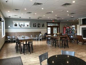
Cheshire Farms Creamery
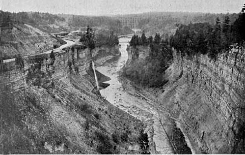
This view of the Genesee River middle falls in Letchworth Park, shows the Genesee Valley Canal clinging to the steep wall of the gorge in the 1860s. Click on the image for more information from Letchworthparkhistory.com.
This week’s hike will follow trail #7 in Letchworth Park. Trail #7 is the portion of the Genesee Valley Greenway through the park. It is also the section of the Greenway with the most impressive relics of the Genesee Valley Canal. This will be an out-and-back hike with a slightly different return route at the end.
Trail #7 starts at Oakland Rd about a mile outside of Nunda. Here we will walk next to the original locks that allowed boats to climb the hill to the River. The canal operated in this section between 1862 and 1878 and the right of way was sold to the Genesee valley Canal Railroad Company which built a railroad along much of the canal towpath. As we walk next to the canal lock, the railroad took another route slightly north. In about a half mile, the canal path rejoins the rail path up to Short Track Road. On the return walk we’ll take the Greenway path away from the canal route; we’ll walk as far as Oakland Road and then turn right back to the parking lot.
The Meeting Place: We’ll all meet at the Oakland Road parking area in Nunda (42.578516,-77.971108) at 1:45pm for a scheduled start at 2:00pm.
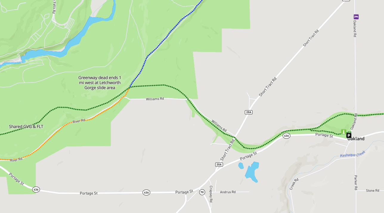
The Naturalists will start from the Oakland Rd parking area, following the canal to the junction with the railbed. It is just over a mile to Short Tract Road, where the Naturalists will turn around and hike back to the cars, using the railbed route all of the way, for a two mile hike.
The Tourists will follow the same route to Short Tract Rd. There is a slight jog to the right to follow a detour along Williams Rd. When the road turns left, continue straight into the woods on the Genesee Valley Greenway. The next road is River Rd, also known as Trail #8, where the Tourists will turn left and follow the road south to their cars on NY 436..This hike will be about 3 miles total.
The Climbers will follow the Tourist route to River Rd, where it will continue on the Letchworth Branch of the FLT until 3:00pm when we will turn around and walk back the way we came. On the return walk we’ll keep to the Greenway all the way rather than turn along the canal route. We’ll walk to Oakland Road where we’ll turn right and walk the road back to the cars.
In recognition of the rising COVID-19 pandemic there won’t be a social on this hike. It will likely be cold and getting dark by the time we get back to the cars, and indoor locations are not advised as yet.
From Springwater: Follow NY-15 South to Wayland, then turn right on to Route 63 to Dansville. In Dansville, turn left on Ossian Street (Route 436). Follow Route 436 west through Nunda to Oakland Road. Turn right on Oakland Road and the parking area will be on the left. Note that Oakland Road is easy drive past – it’s a small two lane road that goes off to the right 1.2 miles west of the traffic lights in Nunda. The street sign is set back from the 436. There is a trailhead shelter clearly visible on Oakland Road from the junction with Rt. 436.
From Naples: Take Route 21 to Wayland, then continue west on Route 63 to Dansville. In Dansville, turn left on Ossian Street (Route 436). Follow Route 436 west through Nunda to Oakland Road. Turn right on Oakland Road and the parking area will be on the left. Note that Oakland Road is easy drive past – it’s a small two lane road that goes off to the right 1.2 miles west of the traffic lights in Nunda. The street sign is set back from the 436. There is a trailhead shelter clearly visible on Oakland Road from the junction with Rt. 436.
There are two small parking areas at the trailhead. Please park carefully – I don’t think that roadside parking will work because Oakland Road is narrow and curvy.
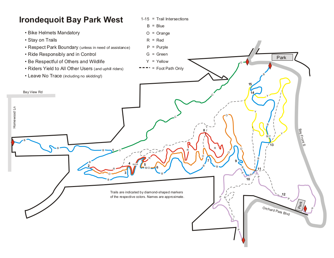 A month ago we hiked in the Abraham Lincoln Park on the east side of Irondequoit. This month we are headed across the bay to Irondequoit Bay West Park. The terrain on this side is quite similar to the east side, but the park has a different feel, partly because it is open to mountain bikes. The extensive trail system is mostly maintained by the Genesee Regional Off-road Cyclists. Due to the season, we aren’t expecting to meet many cyclists, but please remember that we are enjoying the trails because cyclists have volunteered to maintain them.
Most of the trails we plan to follow are shared use trails, and all users should be aware of traffic. Cyclists are expected to yield to hikers who are hiking, but hikers who are enjoying the scenery should step aside for cyclists.
During our pre-hike, these trails were very easy to follow. The leaves had been swept from the trails and the trails were well used and smooth. The trails are only blazed at intersections, so be careful to check your trail each time you come to a crossing.
The are many ways to follow the trails. Below are suggestions for three length hikes. A PDF of all of the maps can be downloaded and printed. Please click on each map to the right for more details. 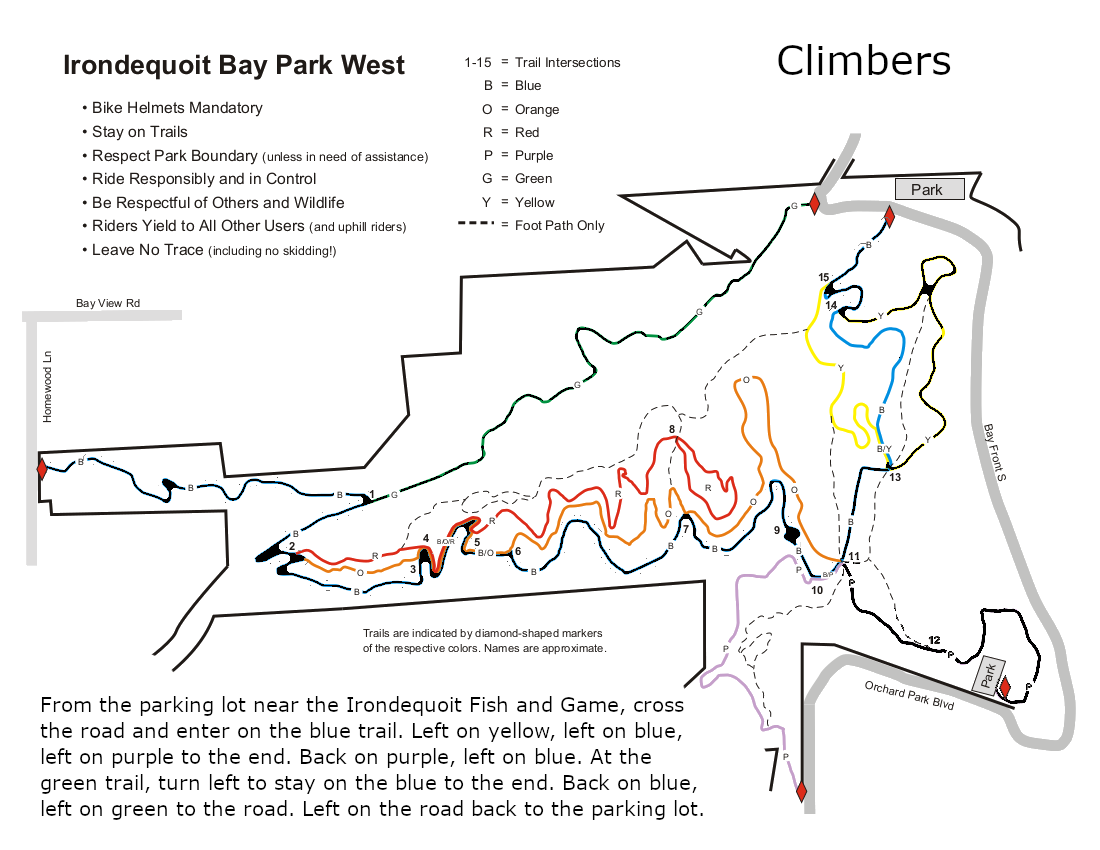
All hikers will meet on the north east side of the park where Glen Haven Rd enters the park. There is a small parking area at the sharp corner at the end of the Green trail, and a second larger parking area about 400 feet east on the left near the entrance to the Irondequoit Fish and Game store and across from the start of the Blue trail.
The Climbers will walk west on the road about 100 yards to enter the park on the green trail. This trail follows above an old path to cottages. All that is left of the cottages are the foundations to the right of the trail. The green trail ends at the blue trail near a bridge across the creek. Turn right on the blue trail as it climbs to the west side of the park. Trail maintenance has done a nice job on the bridges of this section. At the road, turn around and follow the same trail back down to the green trail. Turn right to stay on the blue trail The blue trail follows the southern edge of the park, parallel to the red and orange trails, so pay attention to the blazes if you want to stay on the blue trail. At intersection 11 (see the map) at the eastern side of the park, a purple trail leads down to the southern parking area. Based on interest and time, the Climbers will explore this trail, down and back. On returning to the intersection, turn right on the blue trail. At the next intersection, turn right onto the yellow trail for a pretty trip above the bay. When you return to the blue trail, turn right to return to the cars. (An alternate route follows a foot path up the hill between the blue and yellow trails for a view of the bay from on high!).
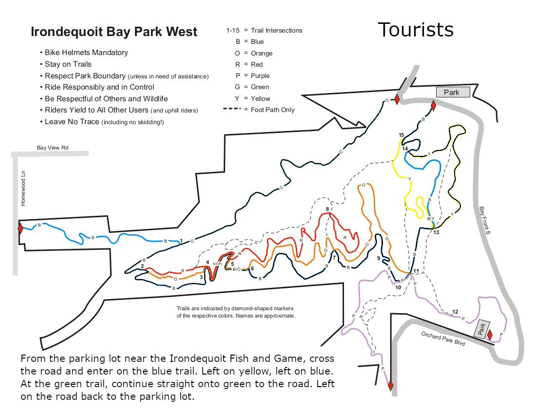
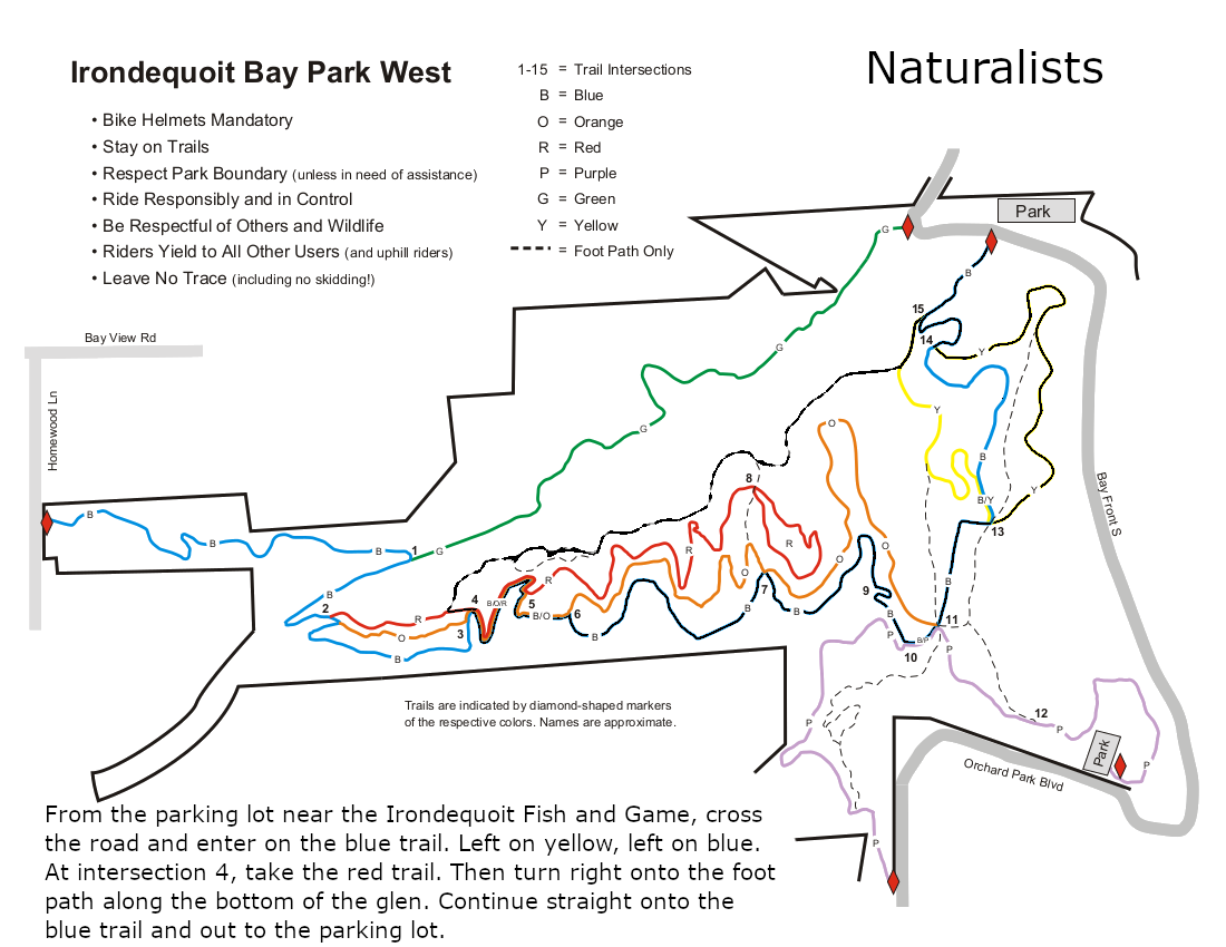
The Tourists and Naturalists will start on the blue trail directly across from the main parking area. At the first intersection, the yellow trail goes to the right and the blue trail heads up the hill. This is a good time to notice the blazes the you will see at every intersection. Stay on the Blue trail to the next intersection where you want to switch to the yellow trail to enjoy an overlook of the bay. The yellow trail will rejoin the blue trail and hikers will continue straight onto the blue. At this intersection, there are two steep trails up to the tops of the hills. These are not blazed and are for the use of hikers only (no bikes). Check the map if you would prefer to follow these trails.
 At the next intersection (with blue, purple and orange blazes), continue straight on the blue trail.
At intersection 4, the Naturalists will leave the blue trail to stay on the red trail for a very short distance and then turn right to follow a hiking only trail back to the cars.
The Tourists will stay on the blue trail until it comes to the green trail and then follow the green trail back to the road and the cars.
 With COVID and the early sunset, no social is planned following the hike. Hikers may want to explore the road along the bay to the south side of the park.
Please enjoy the holiday season and stay safe for your family and neighbors.
Directions:
From Springwater: Follow NY 15A or NY 15 north to I-390. In Rochester, merge right onto I-590 N. At the intersection with 490, stay left to continue on 590N. Take exit 9 for Bay View Rd. Turn left onto Bay View Rd, and take the 3rd right onto Glen Haven Rd. In less than a mile, you will enter the park (the road name changes to S Glen Rd and then to Bay Front S, but don’t worry about that). There are two parking areas within 400 feet of the entrance to the park.
From Naples: Follow NY 21 north to NY 64 in South Bristol, to US 20. Turn left on US 20, then in a mile, turn right on NY 444 to Victor. Turn left on NY 96. In 2.9 miles enter I-490. Use exit 21 for NY 590N. Take exit 9 for Bay View Rd. Turn left onto Bay View Rd, and take the 3rd right onto Glen Haven Rd. There are two parking areas when you reach the park.
From Canandaigua: Follow NY 332N to the Thruway west. Take exit 45 for I-490. Take exit 21 for NY 590N. Take exit 9 for Bay View Rd. Turn left onto Bay View Rd, and take the 3rd right onto Glen Haven Rd. There are two parking areas when you reach the park.
Conditions Update 12-26: There is about 2″ of compacted snow over an icy base on the trails. A revised hike plan is described below, following the compacted trails that are recommended for use Sunday. Skiing is not recommended. We suggest poles and spikes or YakTrax to ensure good footing.
Please join us for our post-Christmas hike at Cumming Nature Center, in the hills above Naples. Conditions are good for a hike on trails with about 2″ of snow over a compacted base. Cummings is a branch of Rochester Museum and Science Center; if you are not a member of RMSC, there is a $5 access fee to the Center; this provides access to their rest rooms, birding platforms, snacks (free popcorn) and impressive exhibits on local wildlife. Please wear masks and observe social distance rules throughout the event.
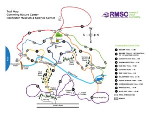
We will meet at 1:50 inside the Visitors’ Center and split into groups to enjoy a nice walk. Trails of various lengths extend north and south from the Visitors’ Center. Naturalists and Tourists will follow the Beaver Trail through the Cathedral of Pines to the Beaver Pond and return by the Salamander and Conservation Trails for a distance of about 2.5 miles. Climbers will head for the Beaver Pond and Salamander Trail and then make a larger loop on the Logging Road, and the Conservation Trail, for a total of about 4 miles.
No Scheduled Social: Due to the current pandemic surge we are not scheduling social gatherings after our hikes. However the open area at the lower level of the Visitors’ Center will be available for anyone who feels comfortable bringing their own snack and making use of the tables and chairs. The Center closes at 5 PM.
Directions
From Rochester and points North: Take 390 South to Routes 5 & 20, Proceed to Rt15A in Lima. Head South on Rt15A to Route 20A in Hemlock, Head East on 20A to East Lake Road in Honeoye. Proceed South on East Lake Road a short distance to County Road 33, (there are signs pointing the way from the junction of East Lake Road and County Road 33). Turn East on County Road 33, then Southeast on Pinewood Hill Road, which becomes becomes Gulick Road. After 5.6 miles the CNC entrance will be on the right.
From Springwater: Go North on Rt 15A to Route 20A in Hemlock, Head East on Rt 20A to East Lake Road in Honeoye. Proceed South on East Lake Road to County Road 33 (Signs point the way from the junction of East Lake Road and County Road 33). Turn East on County Road 33, then Southeast on Pinewood Hill Road. This becomes Gulick Road. After 5.6 miles the CNC entrance will be on the Right, about 1.5 miles past the Wesley Hill parking lot. OR, go to Naples and follow the directions below. They are both about 23 mile routes.
From Wayland, Naples, and points South: Follow NY 21 East from Wayland, thru N.Cohocton to Naples (11.4miles). Turn Left onto Clark Street (County Rd. 36), heading North (Next to Middletown Tavern). Take first Right onto Gulick Road. Follow Gulick Road for 6.6 miles. CNC will be on the Left.
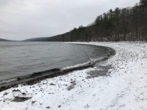
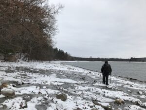
 This Sundays will be the first “Springwater Trails” hike of the new year. We will all meet at the DEC parking lot right off Rt. 15A. This will be a “out and Back” hike along the access road to the south boat launch and continue on along the south trail for about 700 feet at which time the hikers will have a choice to continue along the south drop down to the shoreline and hike the shoreline for 45 minutes at which time hikers can exit back up to the south trail. This will bring the hikers back up to the end of the maintained portion of the south trail. Climbers may wish to explore beyond this point. .At this point, hikers can return back to the parking lot along the south trail and boat launch access road.
All three groups can follow the same routes and adjust their hike according to their capabilities. The shoreline hike is fairly easy with very little obstructions. There are a few small water runoffs along the edge but were manageable at the time of this writing. Hiking poles are recommended and traction devices may only be necessary if the shoreline becomes icy. There are other exit points along the lakeshore for hikers if they wish to terminate the shoreline hike,
DIRECTIONS
;From Rochester: Take Interstate Rt. 390 South to Avon exit and turn left onto Rt. 5/20. Drive east for about 4 miles into Lima and turn right onto Rt. 15A. Continue south on 15A for several miles to the south boat launch DEC Parking lot,
From Naples : Take Rt, 21 south to North Cohocton and turn right staying on Rt. 21 to Wayland. Turn right at red light and head north on Rt. 15A for about 8 miles. The DEC parking lot will be on your right.
From Dansville : Take Rt. 63 south to second red light and turn left onto Rt. 15A. Drive about 8 miles. DEC parking lot will be on your left.
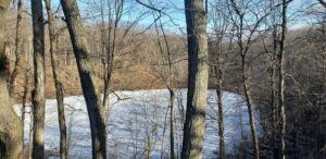
 Now that we’ve seen the southeast corner of Hemlock Lake from the beachfront, on Sunday January 10 we will explore the opposite corner of Hemlock on the Bur Oak Trail and the Walnut Trail, both on State land within the Canadice Hemlock State Forest. One section is a snowmobile trail, and the other follows in the woods parallel to the shoreline. For those who enjoy stony beach walking, there will be an opportunity for that too.
 Meet at 1:45 at the northwest corner of Hemlock Lake at the Rix Hill Road trailhead parking area just west of the Hemlock Outlet and Hemlock Lake State Park. There are small parking areas on both sides of the road, and a kiosk on the south side. All hikers will first follow the Bur Oak Trail north along the Hemlock Outlet to a grassland loop off Blank Road, and return for a total of about 2.5 miles – this is a snowmobile trail. We will then cross the road and follow the Walnut Trail south through the woods for about .75 miles and back; this requires some agility in stream crossing. The final leg will be a walk down the Hemlock shoreline and back, fording small streams as we pass them. Bring good waterproof winter footwear and poles. Those wanting a shorter hike will have ample opportunity to bail out as we pass the starting point twice.
No social due to Covid guidelines.
Directions: from Springwater: Head north on NY-15A. At the end of Hemlock Lake, turn left on Rix Hill Road. Pass the park entrance on your left and go over the Hemlock Outlet bridge. The parking areas will be on both sides of the road, or park on the shoulder.
Directions: from Canandaigua, Honeoye and points east: From Honeoye, continue west on Main Street (Route 21A) to Route 15A in Hemlock. Make a left, go a half mile, and take a right on Rix Hill Road. Pass the park entrance on your left and go over the Hemlock Outlet bridge. The parking areas will be on both sides of the road, or park on the shoulder.
Directions from north and west: Take Route 390 south to Exit 9 (Lakeville-Livonia). Go south on Route 15 into Livonia, the southeast on 20 A. Make a right after 3.9 miles on County Road 56 (Federal Road), then a left on Adams Road after .6 miles. Take the second right on Blank Road. In a mile, fork left at Rix Hill Road and go down the hill to lake level. The parking lots will be at the foot of the hill, just before you come to the lake.
Looking for brochure.or mailing list so I can receive it in the mail.
Nothing opens up for mailing list.
There’s all kinds of very bizarre ads and post for viagra and other drugs above on calender page.
Please let me know if there’s a brochure available