
Hikes led by Springwater Trails are generally held on Sunday afternoons and appear in this calendar in green.
| Sun | Mon | Tue | Wed | Thu | Fri | Sat |
|---|---|---|---|---|---|---|
| Lehigh Valley Trail Hike or Bike in Rush, NY 2:00 pm Lehigh Valley Trail Hike or Bike in Rush, NY @ Stevens-Connor Lehigh Valley Lodge Apr 6 @ 2:00 pm – 4:00 pm Come join us for a leisurely hike or bike along the Lehigh Valley Trail on Sunday April 6th! With its flat even surface, the trail is a hidden gem for walking, hiking, jogging, biking. It is a vital link in … Continue reading | ||||||
| Ontario County Park at Gannett Hill Hike-Naples 2:00 pm Ontario County Park at Gannett Hill Hike-Naples Apr 13 @ 2:00 pm – 4:00 pm  Save the date! This is one of our group favorite hikes. Ontario County Park at Gannett Hill is one of the highest points in Ontario County and located in the scenic Bristol Hills. At an elevation of 2,256 feet above … Continue reading | ||||||
| No Hike-Easter Break 2:00 pm No Hike-Easter Break Apr 20 @ 2:00 pm – 4:00 pm No hike has been scheduled for this date due to the Easter Holiday. Enjoy the break, spend time with loved ones and eat chocolate bunnies. This will give you something to burn off next week  | ||||||
| Mystery Hike-Details Coming Soon 2:00 pm Mystery Hike-Details Coming Soon Apr 27 @ 2:00 pm – 4:00 pm Mystery Hike coming your way….details under construction. Please check back. |
This Sunday’s hike will be on a tree farm on Schribner Rd, Wayland. In 1932, the original lot was used primarily for sheep grazing and growing hops. Many acres were barren, eroded land with only 2 small woodlots and hedgerows. Over the years, more acres were added and many thousands of various tree species were planted. Today it is still being maintained on the DEC forest management program.
Hikers will be following mostly logging roads or grass trails around ponds. There are many springs and the water table is high, so hiking routes will be wet in places. Waterproof footwear is highly recommended. Because of bow season or poor weather conditions, wearing a bit of hunter orange if you have it would make you more visible (although there should not be any hunters on the property today). Dogs must be on-leash at all times and well behaved.
Please arrive by 1:50 for parking instructions and sign-in by the camper trailer.
Climbers: From the top of the driveway, ascend the hill following the ORANGE survey tape markers. Please ignore any orange ground flags you see along the hike, as those mark seedling trees. At the intersection at the top of the first hill, go straight across and continue following orange tape down Quarry Rd to an Adirondack style lean-to at the bottom. From here head to the large wood pile, then bear right. This leads to a field which you will cross. Follow this trail to the right around the bend and turn left at the flagged curve. This takes you downhill to the Cohocton River.
Those who wish can climb the steep grade back up to the field, or backtrack along the field. Hike back to the first corn field but turn right this time. Follow it around the end and turn right into the woods at the orange flags. This trail goes up and over a hardwood ridge; down the other side, across a stream and up again to an open field at the top of the hill with a good view.
Proceed straight across to the other side and continue to follow orange tape down the other side, and then up again to a bench with a very nice view over a red pine clear cut. You will now follow both orange and green markers back to the starting point.
Tourists: The first section is a loop trail of about a mile. From the top of the driveway, ascend the hill up and turn left. Follow the GREEN survey tape straight past a small spring and pond on the left. Go past a neighbor’s property marker on the right and follow markers up and across the hill. You should see some trees marked with blue tape that are scheduled for removal. Then you will come back down on a smaller trail to the first road and back to where you started. The next section will pass straight uphill, merging with the orange markers, and at the intersection, go straight across. Green markers will then split with orange, with green turning left through hardwoods. You will pass a large woodpile on your left. When you come to the open fields, follow the green flags to the left. This will take you to the bench with a nice view where the climbers (orange tape) will also be hiking. Follow both orange/green back to starting point.
Naturalists: Across the road there are ponds with grass trails. Because it is extremely wet behind the main pond, we will avoid that area in getting to the woods. Walk across the lower field to the south (left) to the bottom corner. Turning right over a small culvert bridge will bring you into the woods. Here you have two choices: you can either go though the old spruce forest bearing left at the first intersection as far as is comfortable OR go a short distance around to the left where there is another pond. There is a small trail around the back of this pond and then a mowed lane up to the road where the original farm house is located.
Following the hike we will have a social around a campfire with hot-dogs. Please bring something to sit on, a dish to pass, and your beverage of choice (or you can make a small $5 donation to the social fund).
Directions:
From Hemlock and Springwater: ***Please note that most mapping programs will direct you there via Strutt St. and then some very poor, seasonal dirt roads. The following directions will keep you on paved roads and bring you to the property from Tabors Corner Rd.
From Hemlock, travel south 10 miles and take a sharp left turn onto Wheaton Hill Rd.
From the flashing light in Springwater, travel north 3 miles and turn right onto Wheaton Hill Rd.
Then proceed 3.3 miles and turn right at the stop sign onto Wetmore Rd for 1.2 miles. Turn right onto Tabors Corners Rd for 3.5 miles then another right onto Schribner Road (just past a Nate McMurray sign). Hike parking will be .5 miles on the right.
From Wayland: At the intersection of NY 15 and NY 21 in Wayland, travel east on NY 21 N for 3 miles and (at the Bowles Corners sign) turn left onto Tabors Corners Rd. for 2 miles. Turn left onto Schribner Rd and continue .5 miles to parking on right.
From Naples: Take NY 21 South, turning right through the small town of N. Cohocton, then approx 3.8 miles to the Bowles Corners sign. Turn right turn onto Tabors Corners Rd (Steuben CR 37) for 2 miles. Turn left onto Schribner and continue .5 miles to parking on right.
This Sunday’s hike will be a maintenance session on Wheaton Hill in Springwater. We won’t be attempting to whack the grass this year, though if you want to you are welcome to bring a weed whacker and have at it. If you do plan to use a weed whacker, PLEASE BRING EYE PROTECTION! These devices can kick up a lot of dust and small stones. We will be cutting back the roses and other growths, and we’ll be sawing up some trees that have fallen across the trails. If the grass is too long for comfortable walking we will call in the City of Rochester to cut it – they have heavier equipment than we can bring to bear.
Bring gloves to protect your hands, loppers to cut branches and if you have one, a small saw for branches that are too large for the loppers.
The initial plan for a social afterwards is Sammie’s in Springwater. We’ll take alternative suggestions before we fire up.
Directions: Wheaton Hill is the first right turn north of the intersection of Rt 15 and Rt 15A in Springwater (0.9 mile north of the intersection). The trail head is 0.5 miles up Wheaton Hill just before the road turns straight east and heads up the main hill. More details are on the directions page.
What to bring:
- Gloves and clippers – hand clippers or long handled loppers for larger branches.
- A weed whacker if you want to cut grass, with gas mixture and extra string.
- Small bow saw.
- Plastic grocery bags in case you find any litter.
- Water to keep hydrated.
- Eye protection.
Description
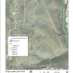
This preserve, maintained by the Finger Lakes Land Trust, is a perfect refuge during hunting season. In fact, out hikers will be performing a service to the land trust by patrolling the woods as they walk. No worries. In sixteen seasons, patrollers have never encountered a hunter.
Steege Hill Preserve is about 800 acres, acquired in 2001 from an anonymous donor. The forest is regenerating after heavy logging in the 1970’s and contains many species of hardwoods. Preserve steward, Bob Corneau, has maintained a network of over 6 miles of trails, constructed largely on the old logging roads. On some of the steep slopes original hardwoods and conifers remain. From its hilltop vantage point there is a bird’s eye view of the Chemung River.
Worth mentioning are two notable creatures that inhabit this forest. Timber Rattlesnakes have long been residents here, especially on the sunlit rocky outcroppings and in the shade of the forest. They may be snuggly out of sight at this time of year, but be cautious when stepping off the trail. The distinctive nests of Allegheny Mound Ants are a common sight at trailside and in clearings that the ants have fashioned for themselves by destroying shade plants to insure adequate sunlight and warmth for the colony. Black bears also have been sighted in the area recently. For more about this preserve go to http://fllt.org/preserves/steege-hill-preserve
Hiking Groups
All groups will depart together from the parking area on Steege Hill Road, heading uphill for about a half mile on a moderate pitch. There are four trail loops to explore.
Please note: The parking space is very limited. Carpooling is highly recommended. Meet at Springwater Town Hall on Route 15 at 12:45 as the drive is 1 hour.
Naturalists will cruise around the Yellow Loop, a gentle 2 mile jaunt with a few small inclines and a tranquil pond. We may be fortunate enough to have the steward of the refuge join this group. If not, a volunteer leader is needed.
Tourists will traverse the blue and orange trails, enjoying a variety of terrain with some moderate climbs, about 3.5 miles. A volunteer leader will be needed for this group.
Climbers will tackle the white and red trails which offer some up and downhill challenges, as well as a nice valley view. Distance is about 4.5 miles.
Hopefully all groups will arrive back at the starting point at approximately the same time.
Directions From Springwater, take I 390 south to I 86 E towards Corning. Follow I 86 east to exit 48, then follow Rt.352 east for 1.5 miles. Turn right on South Corning Rd. for .7 miles. After crossing bridge across the Chemung River, turn left on Steege Hill Rd.. Follow up hill for 1 mile. Preserve is on the left. Look for green and white sign.
Social will be at Tag’s Restaurant, 3037 Rt 252 in Big Flats, It is a very short drive from the hike. Good food. We have feasted there previously.
This month, our third hike in our Letchworth Series covers a relatively short section of the trail from Access D to Access E. The main trail is just 2.3 miles with 0.6 miles of access trail since we will park on the road. There as several park trails to views of the river which will afford us opportunities to adjust the route to accommodate hikes of different lengths.
Since this is a through hike, all hikers will meet at the southern end, Access E. From there, we will car pool back to Access D, in the Naturalists cars (an others if needed), leaving cars are Access E to pick up the Climbers and Tourists at the end of the hike.
All hikers will begin hiking at Access D. The Climbers will follow the blue access trail west to the main trail and then will turn left (south) on the main yellow blazed trail. In 0.7 miles we will cross under power lines, and in another 500 feet we will cross the Letchworth State Park trail #21. The climbers will turn right and follow LSP-21 to an excellent overlook of the river. After John has an opportunity to record the river on his camera, we will return on LSP-21 to the main trail and turn right to continue south. Look for a shelter on the right in 0.1 miles and a couple of crossings of LSP-16 in a mile. Most importantly watch for the Blue access trail. Turn left on the access trail and travel 0.4 miles to the cars at Access E. Total trip is 3.5 miles.
The Tourists will follow the Climbers but will stay on the main trail for a 2.9 mile trip. When the tourists reach LSP-16 (2 miles into the hike), they can check their watches and choose to explore LSP-16 if time permits. This trail goes to the right for 0.4 miles to a river overlook (and 0.4 miles back to the trail). Finally, continue south on the main trail for a half mile to the Blue access trail. It is 0.4 miles out to the cars at Access E. Total trip without exploring LSP-16 is 2.9 miles.
The Naturalists will also follow the Climbers and Tourists down the Blue access trail, then left onto the main trail. After passing under the power lines, watch for the LSP-21 trail. The Naturalists will turn left on the LSP-21 trail (away from the river) and follow that trail for 0.7 miles back to River Rd. Again, turn left on River Rd for about a quarter mile road walk back to the cars at Access D. Total loop is about 2.0 miles.
Following the hike, join us for an optional social at the Sunrise restaurant in Dansville.
Directions:
A self serve carpool will meet at 1:05 at the municipal parking lot behind the Wayland Fire Department off NY-63 in Wayland. Car pooling will leave promptly at 1:15.
From the carpool meeting spot: leave the parking lot to the south along the side of the Fire Department. Turn left onto NY 63, then right on NY-15S. In 2 miles, turn right onto I-390. Take exit 6 to NY-36 Mt Morris. Turn left onto NY-36. Continue past the Correctional Facility and take the 2nd left onto Dutch Street Rd. In 1.3 miles, turn right onto Ridge Rd. At the end turn left onto River Rd. The parking area is on the right.
From Springwater: Head south on NY-15 through Wayland. Turn right onto I-390. Take exit 6 to NY-36 Mt Morris. Turn left onto NY-36. Continue past the Correctional Facility and take the 2nd left onto Dutch Street Rd. In 1.3 miles, turn right onto Ridge Rd. At the end turn left onto River Rd. The parking area is on the right.
From Geneseo: Head out of Geneseo on US-20A West (South St). Continue straight onto NY-63. Continue straight onto NY-408 into Mt Morris. Turn left onto Main St, the right to stay of NY-408. Go past Visitor Center Rd, then turn slight right onto River Rd. In about 2 miles, continue past Ridge Rd. Then the parking lot will be on the right.
To the social at the Sunrise Restaurant: Follow River Rd north to the end. Turn left onto NY-208. At the light in Mt Morris, turn right onto NY 36. In 5 miles, turn right onto I-390. Take the Exit 5. Turn left to go under the expressway, then right onto NY-36. Turn left on Main St, and the Sunrise will be on the right. There is parking out back.
NOTE: The December hike from Access E to Access F is about 5 miles and will be held December 16th, a day when the sun sets at so we will need to start an hour earlier. If there is a lot of snow on the ground, we will need to skip this long section, so please keep your eyes on this page the week before the hike.
 Hemlock Lake Post-Thanksgiving Hike – Work off those extra holiday desserts!
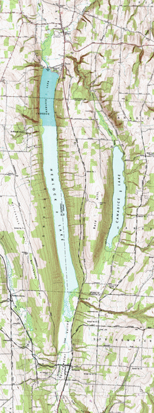
Join us on Sunday, Nov. 25th for a hike along the east shore of Hemlock Lake on the lakeshore section of Rob’s Trail. We will meet at 1:45 at the Boat Launch parking area at the end of Old East Lake Road, and hike south along the shoreline path. The path is fairly level, with some minor stream crossings. Climbers will hike as far as the point where the trail turns away from the lake (about 3 miles) and then return to the cars. Tourists and Naturalists may turn back sooner to keep their hikes to their desired length and time.
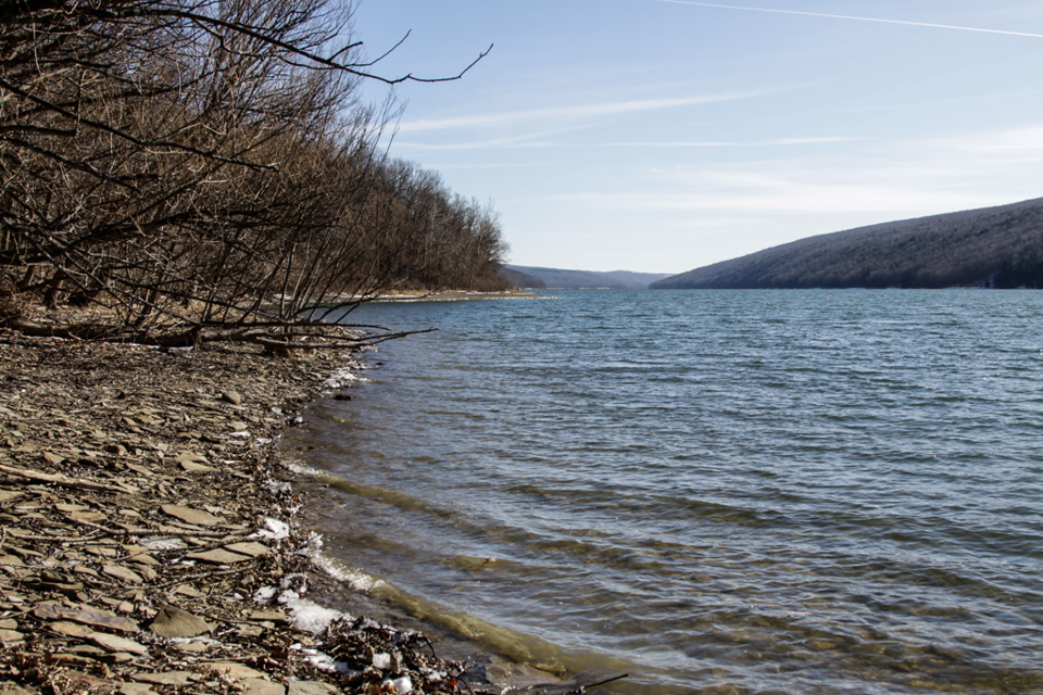 We’ll be hiking along what used to be Hemlock Lake’s East Lake Road, back in the days when there were cottages, hotels and steamboat service on the lake. That era came to an end when the City of Rochester took control of the Hemlock Lake watershed for its public water supply, around 1900. All structures from the cottage era were removed, and the waters of Hemlock Lake, along with the smaller Canadice Lake, continue to supplement the Monroe County water system, while the State of New York has assumed ownership and management of the surrounding land as the Canadice-Hemlock State Forest. The undeveloped shorelines of these lakes offer a soothing contrast to the homes, docks, boat hoists, seawalls, and high levels of activity and investment along the other Finger Lakes shorelines and slopes.
After the hike the social will be at the Cornerstone Market, 8732 Main Street, Honeoye. The Cornerstone is open until 7, but their kitchen closes at 5, so menu orders should be made by phone before 4:30 (585-229-2411). Between 5 and 7 they have soup, chili, beverages and pre-made sandwiches to purchase and eat on site in Peggy’s Rumpus Room.
Directions to the North Boat Launch
From Rochester and Hemlock: Head south on NY-15A. Before Hemlock, NY-20A will enter from the right. At 0.7miles past the intersection where NY-20A turns left, take the first right from NY-15A onto Rix Hill Rd into the Hemlock Lake Park. Take the first left and follow the east lake road to the boat launch, about a mile.
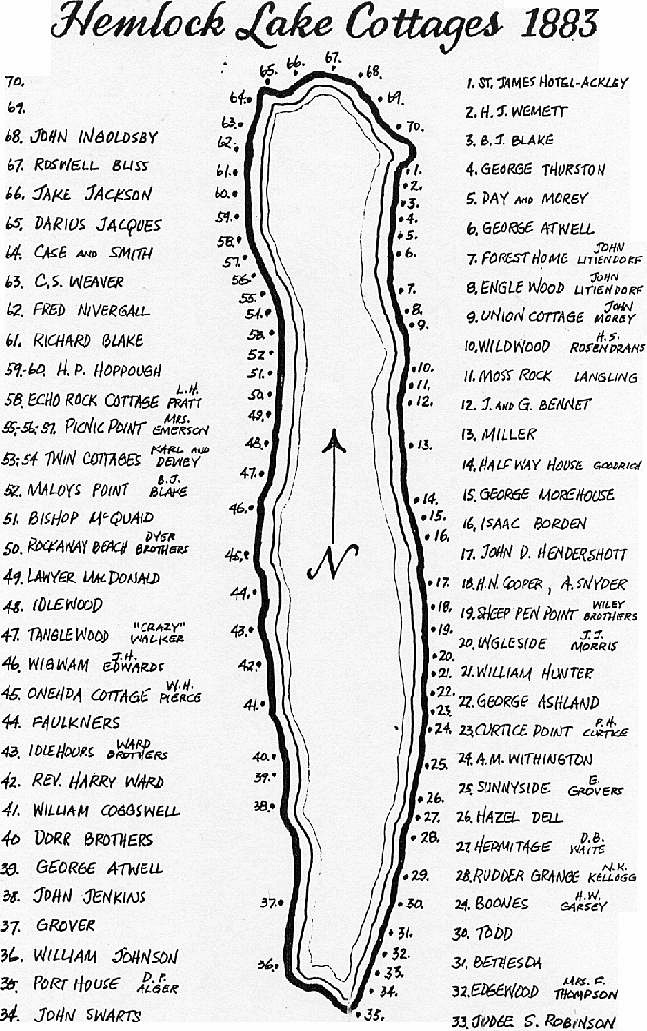
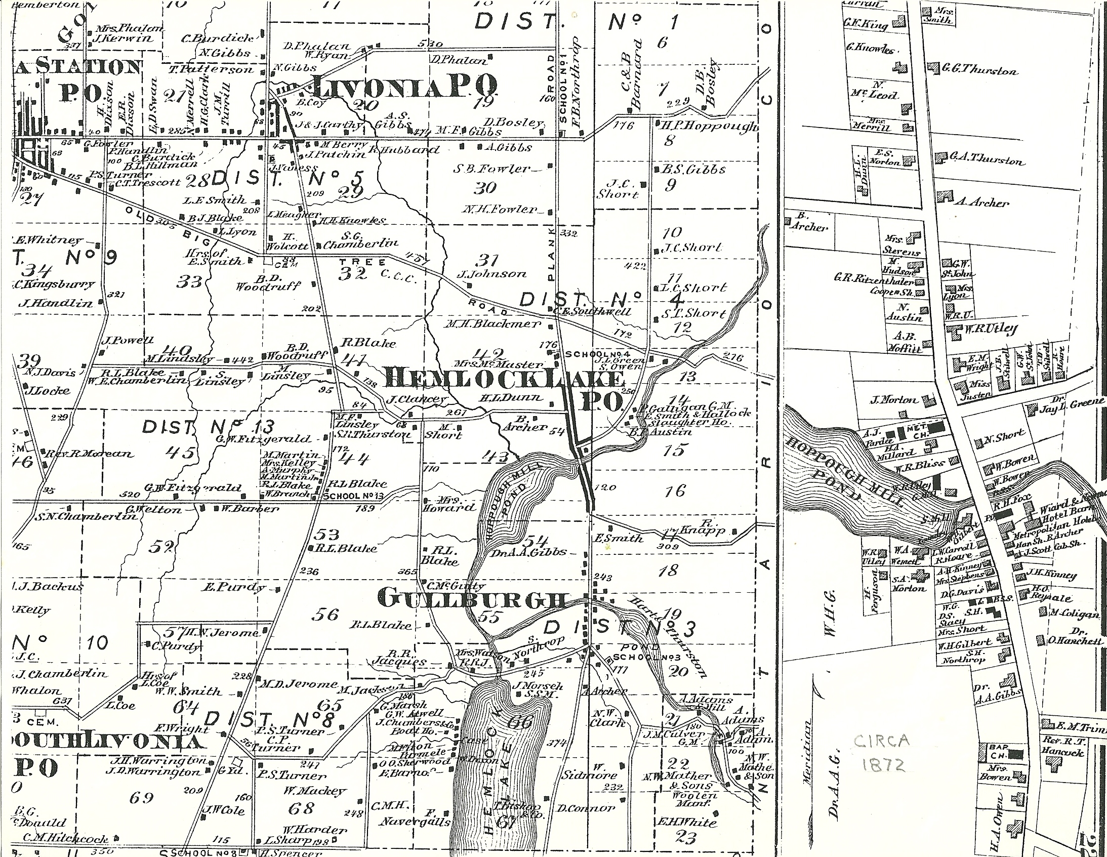
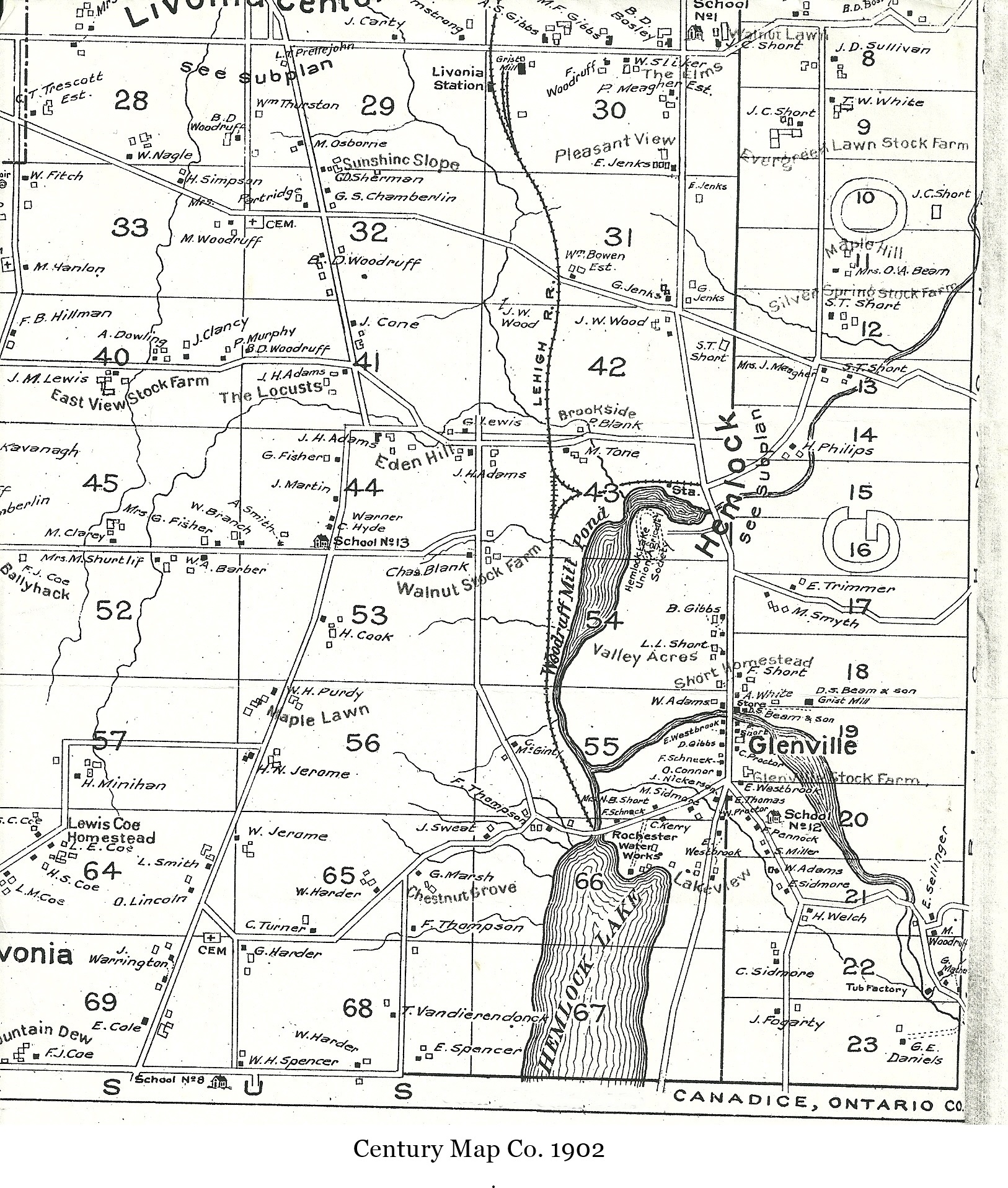
Hemlock 1872. Shows only one cottage along East Lake Rd. Also, check out the 1902 view also.
From Springwater: Head north on NY-15A for 10.1 miles. Turn left on Rix Hill Rd and an immediate left on East Lake Rd. Follow this road to the boat launch.
From Geneseo: Head east on NY-20A through Lakeville and Livonia. Take a slight right to stay on 20A as it joins NY-15A. Stay on 15A when 20A turns left. In 0.7 miles past that intersection, turn right onto Rix Hill Rd. take the first left and follow the east lake road to the boat launch.
Directions to the Social:
From the Boat Launch, go back to Rix Hill Road and turn left on Route 15A. After .5 miles take a right on NY-20A just before Hemlock, and go 4.5 miles to Honeoye. The Cornerstone Market is at 8732 Main Street ,on your left at the intersection with County Road 36.
2017 Map
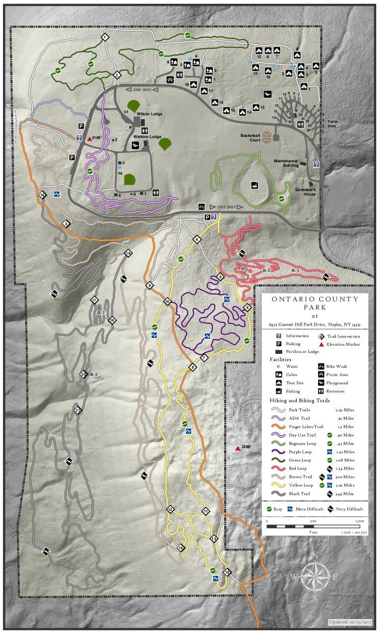
Ontario County Park is really a hidden gem in the area, providing hiking, biking, cross country skiing, fishing (no hunting), and camping or picnicking opportunities depending on the season. This Sunday we will explore some winter hiking trails we haven’t visited much over the years. You should expect some interesting views around the park..
The weather is very interesting right now. On Tuesday Mark and I did a prehike in a howling gale with blowing snow up on top of Gannett Hill. The temperature up on the hill was 29° when the village of Naples was us at 34° and no snow. On Thursday for a second prehike, we ran into snow drifts up to 2 feet deep and invisible trails covered with snow. And now weather forecasts are calling for rain on Saturday, and light rain with temperatures around 50 on Sunday. Right now is a good time to get our you rubber boots and your snow shoes and cross country skis, so you are ready for whatever comes.
Here are our current plans for Sunday – these may change depending on the conditions on Sunday.
The Climbers will explore the black trail on the west side of the park. This trail weaves along near the steep west hill of the park. It’s not clear we were actually on the trail on Thursday, but the hiking was generally quite easy and we have marked a trail with yellow tape so we won’t get lost.
The Tourists and Naturalists will explore the green trail on the north side of the park. Mark will lead this hike which means we may not always know where the trail is.
Following our hike, all interested hikers will gather at the Neapolitan in Naples for Pizza or hot sandwiches.The Neapolitan is located on the west side of Main St one block south of the high school.
Directions: The easiest route is to take NY 64 to Bristol Springs and turn west on Gannett Hill Rd. There is a sign indicating Ontario County Park. At the top of the hill turn right onto South Gannett Hill Road. The park entrance is straight ahead. Follow the park road for about .5 miles to our meeting place which is the parking area along the park road near the information kiosk at the Finger Lakes Trail trail-head.
Parking is available off Main St between Center and Chestnut streets or at the meters on Main St (no cost on Sunday). We will meet on the west side of Main St at the Memorial Fountain at the intersection of Main and Center streets.
Although there will be a few available to share, you may want to bring your own copy of the brochure with you. Here is the link.
As time allows, some people may also want to visit the Roemer Arboretum on the SUNY Geneseo Campus and/or the Genesee Valley Conservancy’s Island Preserve across from Geneseo Central School.
An after hike social will be held at The Village Tavern, 137 Center Street, Geneseo (Menu).
This Sunday’s hike is the 4th in our series on the Letchworth Branch. This hike will join the trail at Access Point F and will follow the trail to Access H for a 5 mile hike. The Tourists and Naturalists will exit early at Access G for a 2 or 3 mile hike. For hikers tracking our progress on this branch trail, you will note that we have skipped the section from E to F. This section is six miles with no early exits – so, we are postponing that hike until March and daylight savings time when less snow should allow us to finish the hike well before sunset.
Starting from shoulder parking at Access F, all hikers will follow the blue trail into the main yellow trail. The climbers will turn left onto the main trail. In a mile and a half, we will stop at a shelter for a sip of water from our individual supply of water which all hikers are expected to carry on all hikes. In another mile, we will cross the abandoned St. Helena Rd. This road carried traffic to a bridge across the Genesee to a hamlet of St. Helena on the west side of the river. At the time of the Civil War, St. Helena had 90 students in its school, but in 1884 and again in 1904, the bridge was washed away by ice jams. In 1920, there were just 6 families left, and the school was closed. The last resident left in 1948. The Mt Morris Dam was completed in 1952 and contained the hamlet within the lake that forms behind the dam during floods. About two miles after crossing the St Helena road, we will turn left onto the blue trail and hike out to an awaiting car to carry us back to our cars at the trail head.
The Tourists will follow the same access trail as the climbers to the main trail, but will continue straight across and continue of the park trail to the edge of the river flats or as far as the hikers wish to go. If they hike for 0.6 miles, they can reach a large old sycamore tree, the largest tree in Letchworth. The tourists will then return on the same park trail back to the yellow trail, and will turn right to follow the hikers (and naturalists). About 500 feet past the shelter, the tourists will leave the branch trail on a blue access trail and hike out to another waiting car on River Rd which will transport them back to cars at the trail head.
The Naturalists will also follow the blue trail into the yellow trail. Turning left they will follow the climbers to the shelter. A tenth of a mile past the shelter, the Naturalists will turn left onto another blue access trail to Access G on River Rd. The Naturalists should wait for the Tourists behind them and share the car ride back to the cars Access F.
Following the hike, please join us for a social at the Sunrise restaurant in Dansville. Prior to the hike, the tourists and naturalists should confirm that they plan to meet the climbers at the restaurant. They can let the restaurant know the number of climbers that should be expected about a half hour later than the tourists and naturalists.
Directions
From Springwater: Take NY 15-N west from the light in Springwater. At the top of the hill and around the curve, turn left onto Liberty Pole Rd (CR 38). Continue straight across Reed’s Corners Rd where it becomes CR 1A, and across Stagecoach Rd where it becomes Springwater-Scottsburg Rd and finally across NY 256 where it becomes Groveland-Scottsburg Rd (CR 1). Finally, in 8.1 miles from NY 15, in Groveland, turn left onto NY 63. Take the first right onto NY 258 (Flats Rd). At the end of that road, turn right onto NY 36. After the Correctional Institution. take the second left onto Dutch Street Rd. In 1.3 miles, turn right onto Ridge Rd. Turn left onto NY 408. Go past Frost Rd and turn left onto Hoagland Rd. At the tee, turn left onto River Rd. Parking is on the right just past the next street (Picket Line Rd).
From Wayland: Take I-390N through Dansville. Take Exit 6 for NY-36. Turn left onto NY-36. After the Correctional Institution. take the second left onto Dutch Street Rd. In 1.3 miles, turn right onto Ridge Rd. Turn left onto NY 408. Go past Frost Rd and turn left onto Hoagland Rd. At the tee, turn left onto River Rd. Parking is on the right just past the next street (Picket Line Rd).
From Mt Morris: Take NY-408 south from Main St. In 2.5 miles, bear right onto River Rd. Continue on River Rd for 5.5 miles, past Ridge Rd, Frost Rd and Hoagland Rd. Just past Picket Line Rd, parking is on the right shoulder of the road.
From Nunda: Take NY 436 west from route 408. In 3.1 miles, turn right onto Oakland Rd. At the end, bear right onto River Rd. Parking will be on the left shoulder in about 3/4 mile.
Directions to Sunrise Restaurant: Follow River Rd south. In 0.7 miles, take a slight right onto Oakland Rd. Turn left onto NY 436. In 15 miles, continue straight onto NY-36. At Main St, turn left. Park on the street in front of the restaurant, or take the driveway past the restaurant to the parking area behind the restaurant.
 This is the Springwater Trails holiday card from 2012.
Enjoy your holidays and we will see you on the trails December 30th, January 1st and all next year!
Please join us on the last Sunday of 2018 for a hike on the Springwater Trail at Pardee Hollow, followed by our holiday social at John’s house. Bring you extra cookies and a dish to pass (or make a contribution to the social fund) and a beverage and join us at John’s for some good conversation and some music – you will be welcome to contribute your own rendition of favorite holiday tunes.
We will meet at the entrance to the Springwater Trail on Pardee Hollow. Lets park on the right hand side heading down hill from the Sugar Shack. The Tourists and Naturalists will carpool up Coates Rd to the seasonal entrance to the trail. They will follow the orange access trail into the blue trail, then turn left and climb to the fields at the top of the hill to enjoy the views. After walking the fields, head back down the blue trail to the cars on Pardee Hollow. Climbers will hike up the blue trail from Pardee Hollow, to the fields at the top. We will then explore the Trillium Trail and head back down the way we came up. This will include more climbing than the Tourist route.
Linda and I did a pre=hike on Friday and the temperature was around 50 and the trail had many slippery leaves to watch for. Sunday is predicted to be at or below freezing, so conditions may change. Poles are recommended and possibly traction devices on your feet, although they may quickly become clogged with leaves. Dress in layers so you can cool down on the way up and bundle up on the way down.
Directions: Please click here for directions,
Looking for brochure.or mailing list so I can receive it in the mail.
Nothing opens up for mailing list.
There’s all kinds of very bizarre ads and post for viagra and other drugs above on calender page.
Please let me know if there’s a brochure available