
Hikes led by Springwater Trails are generally held on Sunday afternoons and appear in this calendar in green.
| Sun | Mon | Tue | Wed | Thu | Fri | Sat |
|---|---|---|---|---|---|---|
| Lehigh Valley Trail Hike or Bike in Rush, NY 2:00 pm Lehigh Valley Trail Hike or Bike in Rush, NY @ Stevens-Connor Lehigh Valley Lodge Apr 6 @ 2:00 pm – 4:00 pm Come join us for a leisurely hike or bike along the Lehigh Valley Trail on Sunday April 6th! With its flat even surface, the trail is a hidden gem for walking, hiking, jogging, biking. It is a vital link in … Continue reading | ||||||
| Ontario County Park at Gannett Hill Hike-Naples 2:00 pm Ontario County Park at Gannett Hill Hike-Naples @ Lookout Parking area Apr 13 @ 2:00 pm – 4:00 pm  This is one of our group’s favorite hikes! Ontario County Park at Gannett Hill is one of the highest points in Ontario County and located in the scenic Bristol Hills. At an elevation of 2,256 feet above sea level, you’ll … Continue reading | ||||||
| No Hike-Easter Break 2:00 pm No Hike-Easter Break Apr 20 @ 2:00 pm – 4:00 pm No hike has been scheduled for this date due to the Easter Holiday. Enjoy the break, spend time with loved ones and eat chocolate bunnies. This will give you something to burn off next week  | ||||||
| Hike Rob’s Trail – Hemlock Lake side 2:00 pm Hike Rob’s Trail – Hemlock Lake side Apr 27 @ 2:00 pm – 4:00 pm Join us on Sunday April 27th to hike the west side of Rob’s Trail, the DEC/Nature Conservancy property in the northeast corner of Hemlock Lake! Options are to hike out and back to the south along the trail from the … Continue reading |
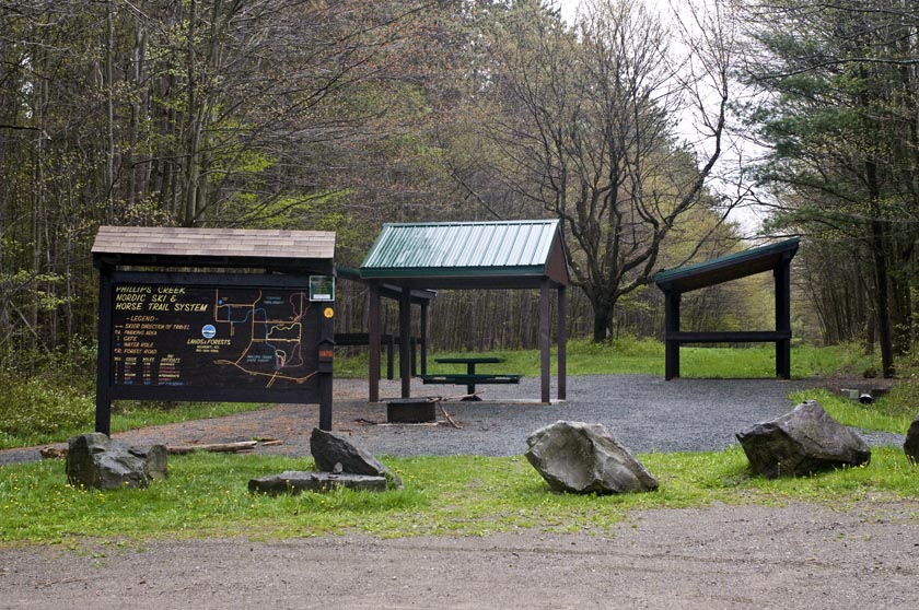
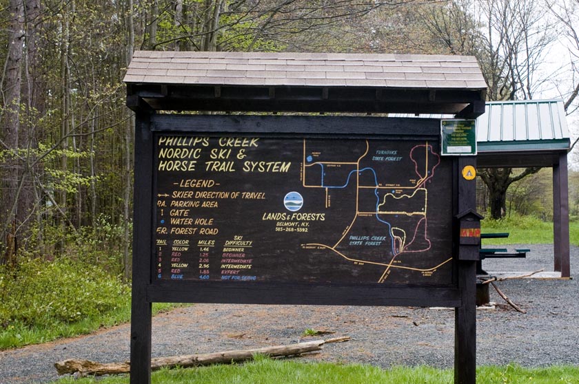 This week’s hike takes us in a new direction, Allegany County and Phillips Creek State Forest. Known as Allegany’ #1 Forest Area. It features 6 well market trails ranging from a 1.46 mile beginners trail to a 1.85 mile expert and a 2.96 mile intermediate section. It is composed of hardwoods and large stands of pines and spruce. During the 1930’s the Civilian Conservation Corps planted large stands of conifers. As of a couple of weeks ago, the lower trails were quite wet so proper footwear is advised in these areas. Maps will be provided.

Foot bridge over stream on trail 4 of the Phillips Creek Trail System for hikers and skiers with by-pass for horses.
We expect to have three groups based on the wishes of the group. All hikers will leave the parking lot and stay to the right onto Trail 3. Half way around the loop, we will get on Trail 4. At Stewart Rd, the climbers will take the loop Trail 5, then rejoin Trail 4 and follow the tourists and naturalists to trail 6 and back to the start point.
Here is a link for Philips Creek and information on Polly Wogg Holler
We have 2 options for the after hike social. Just down the road is Pollywogg Holler described as a Eco-Resort. Featuring pizza cooked in a wood fired oven Sunday’s from 1-6. Live entertainment for June 6 is “All Natural Speed Balls” with a $5 cover. Probably not for everyone. The other option would be the Country Kitchen in Hornell.
Directions to Phillips Creek State Forest.
 I have room for 3 or 4 riders if you want to meet at 22 East Lake Road, Loon Lake. To carpool from Loon Lake, we should leave about 12:45.
A self organized carpool from Wayland will meet at the parking lot behind the Fire Hall off of Rt 63 in Wayland just west of the Rt 15/Rt 21 intersection at 12:45 and be ready to leave promptly at 12:55 for Phillips Creek. Be sure to bring directions in case you need to drive.
From Springwater: Take Rt 15 S to Wayland and continue on Route 21 16.5 miles. When you reach Hornell turn right on County Route 66 go 0.28 miles and turn right on State Route 36 toward Arkport. Go 0.43 miles and merge onto I 86 W NY17 Southern Tier Expressway. Drive 5.4 miles and take Exit 33 Almond. Turn right on Karr Valley Road for 0.5 miles. Turn right onto Main Street NY 21 this takes you thru Almond. After 4.28 miles turn right on Hamilton Hill road for 0.09 miles and turn left onto Rt 244. Continue 1.28 miles and take a slight right and continue on State Route 244. Continue 6.05 miles to Phillips Creek parking lot across from Stuck Hill road.. Drive time is 52 minutes.
ADK Outdoor Expo 2016 is scheduled for Saturday June 11th, 2016, 10:00AM-4:00PM at Mendon Ponds Park. – – Outdoor activities and learning abound at this free event. – –
Here is a hyperlink to ADK Outdoor Expo. http://www.gvc-adk.org/expo
And here is a hyperlink to an article about the 2015 Outdoor Expo, included for reference of the myriad type activities.

Overlook (Honeoye Lake Harriet Hollister Spencer (1887-1962) was born in Rochester, NY. She was a Charter Member of the Rochester Garden Club and was known as a rose expert. She designed the Garden of Fragrance at the Rochester Museum and Science Center and contributed roses from her own garden. In 1963, her family donated, at her request, 679 acres of land to New York State for the Harriet Hollister Spencer State Recreation Area.
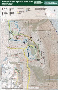 At 2000 feet, this park generally receives and keeps a good covering of snow each winter, and is one of four parks groomed for cross country skiing by the Rochester XC Ski Foundation.
Following the hike, an optional social will be at Sammy’s in Springwater.
The Naturalists will follow Bear Cub Run from the parking area to the snow shoe trail S6 just down the hill from the road. They will cross the overlook, cross Racoon Run, and then will make a short steep hike up to the loop at the end of the road. Then the Pines and Bypass trails will return to the parking area. Depending on the time, a hike to the north around the Big Oak trail may be possible.
The Tourists will similarly follow Bear Cub to the snow shoe trail, but will turn left on Racoon Run. Next is a left for a quick Fox Run loop, back to Racoon Run. Take the next left down to Lower Sidewinder, and follow that loop in a clockwise direction. At the information sign, we will stay to the left to follow a snowshoe trail across the snowmobile trail out toward Canadice Hill Rd and back. From their, heading north on Blue Spruce Run, Whiteface, and Cannonball, will bring us back to the road and the parking area.
The Climbers will follow Bear Cub Run to the road, and then will cross the road to follow the bypass and Chalet trails to the snowmobile trail. From there, we will follow the snowmobile trail south for about 2 miles, crossing into the town of Springwater, where we will turn west to reach the corner of Wetmore and Tibbels Road (which used to be named Springwater Canadice Town Line Road). Total length 3.3 miles, if we do not get lost.
Directions:
Check our standard directions to the HHS parking lot. Climbers coming from Springwater should meet at the corner of Wetmore and Tibbels Rd, to carpool to the parking lot. That way, we will have cars at the end of the hike.
From Springwater: (Climbers only): Take Route 15A north out of Springwater for one mile and turn right on Wheaton Hill Road. Continue to the top of the hill. At the T, turn left on Wetmore Rd. Stay on Wetmore, to the first road on the left (Tibbels Rd which used to be called Town Line Rd). You will see a welcome sign for Canadice. We will park on the right side, and car pool up to the parking lot.
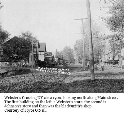 Our first Bicentennial Hike explored the Hamlet of Springwater back in April. This month we are going to explore Webster Crossing, the other hamlet in the Town of Springwater.
We will be meeting at Webster Crossing United Methodist Church, (Route 15, Webster Crossing Road, Springwater, NY 14560) at 4 p.m, The hike will start with a walking tour of Webster Crossing then break up into groups, depending on the distance comfortable for those who are attending. Suggested map routes for the Climbers, Tourists, and Naturalists will be provided.
We will be walking the Morris Road, Story Road, and the All Western Evergreen Tree Farms and other farm and homeowner’s properties depending on permission obtained. More details day of the hike.
The dish-to- pass social will be at the Webster Crossing Church where Gladys Weed, hamlet historian and retired postmaster, will have the history of the hamlet in photos and will be on hand to answer any questions.
Directions:
From Springwater and Wayland: Follow NY 15 north from Wayland to the flashing light in Springwater. Turn left to stay on NY 15. In 3.6 miles, the church is on the left.
From Rochester: Take I-390 South to Exit 9 – Lakeville. Turn left onto NY 15 south. Stay on NY 15 for 16.1 miles to Webster Crossing. The church is on the right.
Please note: For this hike, other routes recommended by your favorite routing tool are also available, and will get you to the church (42.669608, -77.635264) on time. Just enter the GPS coordinates and drive with confidence.
The Rochester Subway stopped passenger service on June 30, 1956 and the museum commemorates the anniversary with a weekend of talks and slide presentations, demonstrations of the Subway’s fully restored “Casey Jones” speeder, food, and vendors. Unlimited rides on the museum railroad bring back memories of travel aboard electric trolley cars of the Subway era. No reservations required. Special event prices prevail.
The New York Museum of Transportation is open year ’round, Sundays only, from 11 a.m. to 5 p.m. Group visits on weekdays can be made by appointment. Train rides are offered on the only electric trolley operation in New York State. In the museum a variety of trolleys, a steam locomotive, and road vehicles on display provide a unique hands-on learning experience for all ages. A large model railroad, gallery, and gift shop are also featured. The museum is located at 6393 East River Road, W. Henrietta, NY. For details: (585) 533-1113 or info@nymtmuseum.org.
 This Sunday, Springwater Trails will be working with the Nature Conservancy to haul supplies for a footbridge across the gully and to help construct the remaining sections of Rob’s Trail extension. Please note the time change as we try to work with the Nature Conservancy schedule. Since we are planning this workday in real time, please check back here for updates. Please send John an email (vp@springwatertrails.org) if you are planning to come.
Rob’s Trail is one of the favorite hikes for Springwater Trails. The Central & Western New York Chapter of the Nature Conservancy built this trail in memory of Rob van der Stricht, their Board Chair who died in 2006. The trail from Rt 15A to Canadice Lake was opened in 2008.
In 2014, the Nature Conservancy announced plans to extend Rob’s Trail down to Hemlock Lake and the along the old road to the North Boat Launch. Based on the map published in the announcement, and on scouting done by Rick Osiecki, Springwater Trails led a hike from the west side of Hemlock Lake to the east side of Canadice last year, and this spring we hiked the partially completed extension from Rt 15A to the Hemlock North boat launch.
The work season for Rob’s Trail is just starting. There is a bridge to be built This Sunday, Springwater Trails will join the Nature Conservancy as they start the planned completion of this trail. Last Friday, we got a message requesting assistance with the work this spring, and decided to devote our trail maintenance Sunday to this trail. John took responsibility for planning and things have fallen into place. So please join us, and bring family members and friends, to help get this work off to a great start.
Details:
We will meet at the new trailhead/parking lot on the west side of 15A. This parking area is slightly north of the end of Old Bald Hill South and the original Rob’s Trail parking area. It connects directly to the Extension trail without crossing 15A. We will meet at 11:00AM. If you can’t make it at 11:00, please come as soon as possible and hike down the trail (west toward Hemlock Lake) to meet us. The upper part of the trail should be easy to follow. Bring work gloves and loppers. Be prepared for some digging in the dirt.
John will cater a social afterwards right at the parking area. Please contact him if you can help with the social – Springwater Trails will pay for the food.
Directions:
From Springwater: Go north on 15A for 6.0 miles. The parking area is on the left just after the north end of Old Bald Hill South.
From Hemlock: Go south on 15A for 5.1 miles. The parking area is on the right just before the north end of Old Bald Hill South.
Just when you thought you had seen the last of us, here we are again, leading our favorite hiking group, on a great level trail in our new home area.
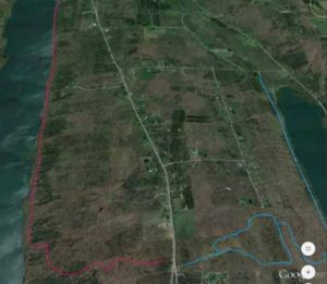
We’re meeting at the west end of the Ontario Pathways trail, In the parking lot on Ontario St., and split into our usual 3 hiking groups. Then, each group will pool into 1 or 2 cars, to their starting point, and hike back to the meeting area. Climbers will go to CR 47, a distance of 5.8 miles. Tourists will go to Freshour Rd., distance 4.3 miles. Naturalists to CR 10, 1.5 miles.
As an added bonus, this time, there are loads of raspberry bushes alongside many parts of the OP trail, and there should be lots of ripe berries, begging to be picked. You can fill your berry baskets to take home, or simply enjoy a healthy trailside snack on your hike.
If you prefer to ride your bike today, the flat OP trail is a great place to do it. Ride east on the trail till 5 PM and head back. A round trip from the Ontario St. lot to Depot Rd. will be about 15 miles.
If you’d like to earn some freebies, doing your favorite activity, leave a little early and pick up an OP passport book at Wegman’s. You will encounter several rubbing spots on this trail. The Wegman family is rewarding you for your healthy lifestyle, so that you will live longer and buy more of their good food.
And, we mustn’t forget our post hike social. The New Covenant Baptist Church is located on the south side of CR 46, where the trail crosses this road, just east of CR 10. The members of this church are very friendly to hikers. There is a picnic table under a shelter (in case of rain). We will bring a folding table and you could bring one too, as well as chairs and, of course, your delicious dish to pass (start baking, Char) and drink.
Tim Wilbur, OP president, is being sent this hike description and hopefully, we will have the pleasure of Tim and some other OP members accepting our invitation of joining us for this one. This hike will be more fulfilling if you visit the good OP web site, www.ontariopathways.org, before the hike. You can print a map of the trail to take with you, which you should find quite helpful.
Directions from Springwater:
North on NY 15A
R on US 20A
At the T, where US 20A joins NY 64, turn L
Go R on Fisher Hill Rd.
L on CR 32
At 5 & 20, go straight. Becomes Bristol St.
L on Main St.
R on Ontario St, to Parking lot on L side.
If you want to go to Wegman’s before the hike:
Follow above directions. When you get to 5 & 20, turn R. Wegmans is on the R side.
From Wegman’s, R on 5 & 20
L on CR 10, just past Aldi on L
Go straight across first rotary, 3/4 around on second. This will put you west on CR 4, which becomes Ontario St. Go to parking lot on R
Looking for brochure.or mailing list so I can receive it in the mail.
Nothing opens up for mailing list.
There’s all kinds of very bizarre ads and post for viagra and other drugs above on calender page.
Please let me know if there’s a brochure available