
Hikes led by Springwater Trails are generally held on Sunday afternoons and appear in this calendar in green.
| Sun | Mon | Tue | Wed | Thu | Fri | Sat |
|---|---|---|---|---|---|---|
| Lehigh Valley Trail Hike or Bike in Rush, NY 2:00 pm Lehigh Valley Trail Hike or Bike in Rush, NY @ Stevens-Connor Lehigh Valley Lodge Apr 6 @ 2:00 pm – 4:00 pm Come join us for a leisurely hike or bike along the Lehigh Valley Trail on Sunday April 6th! With its flat even surface, the trail is a hidden gem for walking, hiking, jogging, biking. It is a vital link in … Continue reading | ||||||
| Ontario County Park at Gannett Hill Hike-Naples 2:00 pm Ontario County Park at Gannett Hill Hike-Naples @ Lookout Parking area Apr 13 @ 2:00 pm – 4:00 pm  This is one of our group’s favorite hikes! Ontario County Park at Gannett Hill is one of the highest points in Ontario County and located in the scenic Bristol Hills. At an elevation of 2,256 feet above sea level, you’ll … Continue reading | ||||||
| No Hike-Easter Break 2:00 pm No Hike-Easter Break Apr 20 @ 2:00 pm – 4:00 pm No hike has been scheduled for this date due to the Easter Holiday. Enjoy the break, spend time with loved ones and eat chocolate bunnies. This will give you something to burn off next week  | ||||||
| Hike Rob’s Trail – Hemlock Lake side 2:00 pm Hike Rob’s Trail – Hemlock Lake side Apr 27 @ 2:00 pm – 4:00 pm Join us on Sunday April 27th to hike the west side of Rob’s Trail, the DEC/Nature Conservancy property in the northeast corner of Hemlock Lake! Options are to hike out and back to the south along the trail from the … Continue reading |
- Are your energy bills too high?
- Are you a homeowner, renter or landlord?
- Do you want to know how your home uses and loses energy?
- Want to know more information on how to make home energy improvements like furnace or insulation repairs?
- Are you interested in learning about financing options such as low interest loans and grants?
If so, attend our Workshop to find answers to these questions and how you can qualify for a free or reduced cost home energy assessment.
Attend our Free Home Energy Workshop. Join us and the Little Lakes Sustainability Network
![]()
 RSVP Today!
Call: (585) 442-2030 ext.213
Email: saveenergy@pathstone.org
www.PathStoneEnergyInfo.org
Choose up to three seminars on topics of interest to landowners in the Genesee Valley region, including Technology for the Landowner, Hardwood Tree Plantations in the Genesee Valley, Solar Power, and Securing Your Legacy. Registration fee includes supper. For complete details and registration information, see the schedule or contact Dave Bojanowski at (585) 243 219 or daveb at geneseeValleyconservancy.org.
Landowners, interested in hosting public hiking trails on their property, will benefit from the Landowner Liability Conscerns workshop being held at 7:00.
As a hobbyist maple syrup producer David Colligan, Colligan Law, LLP, has focused his practice in the areas of Natural Resources Law including Timber and Oil and Gas Law. He will cover a variety of liability legal issues related to land owners such as timberland, property posting and oil and gas law.
You may be interested in additional Genesee Valley Conservancy events.
The Nature Conservancy of Central and Western New York has been planning to extend Rob’s trail down to Hemlock Lake for several years. Last summer several work days were held, building trail part way down from Rt 15A, and extended the lake side trail south from the north boat launch. A bridge is planned to cross a gorge and provide a wonderful and safe view of a waterfall on the way down to the lake. Currently there is a temporary route marked across the creek and the rest of the way to the lake.
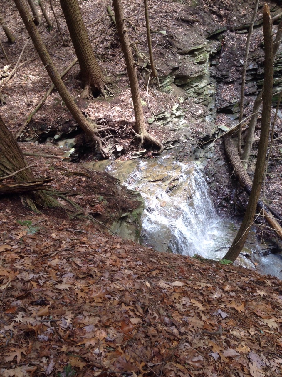 On Sunday, join us for a spring hike on this new trail and an optional social following at Peggy’s Rumpus Room in Honeoye. We will meet at the Rob’s Trail parking lot, and will split into three groups. The Climbers will hike down to the lake and connect to the new trail north to the North End (about 5 miles). The Tourists will hike down to the lake, and then will return back up the trail to the cars. This hike is about 3 miles, but makes up for the shorter distance with the steep climb back to the cars. Finally, the Naturalists will hike down the trail about half way to the lake where the bridge is planned. From there, they will return back to the cars, taking some time to explore a branch trail to the location of the proposed western parking area. This hike will be approximately 2.5 miles.
Following the hike, our optional social will be held at Peggy’s Rumpus Room at the Cornerstone Market. This is a small dinning area with soup, sandwiches and salads, plus bottled beer, and non-alcoholic beverages from the Cornerstone Market. To streamline the social, please RSVP to info@springwatertrails.org and to thecornerstonemarket@gmail.com. Please use the subject line “Springwater Trails Social April 3 at 4:30” with the number of people you are bringing and with your salad or sandwich order. You can find a menu at on their website. The restaurant is 10 miles from Rob’s Trail – go north on Rt 15A. Turn right on Rt 20A at Hemlock. The restaurant is at 8732 Main Street near the light at CR 36.
The Stid Hill Multiple Use Area is a 847 acre tract of land situated in the townships of Bristol and South Bristol in Ontario County. It is bounded by Route 64 on the west and Dugway Road on the north. Ganargua Creek, better known as Mud Creek, flows along Route 64. At one time, Stid Hill was productive sheep and cattle grazing land. Today the grazing has been eliminated. The mixture of steep hills, ravines, gullies, gorges, woods, and open areas create scenic vistas and also provide varied wildlife habitats.
The hike on Sunday 10th April 2016 will begin at the Dugway Road trail head. The initial quarter mile is a good path, but steep and uneven. This ends at a prominent “Stop” sign and a gate. This is a little misleading; a public trail continues past the Stop sign for a hundred yards or so and then swings to the right – follow the yellow Foot Trail buttons nailed to the trees and not the yellow paint dabs; the dabs lead away from public lands and will drop you on Stid Hill Road where it is still a dirt road.
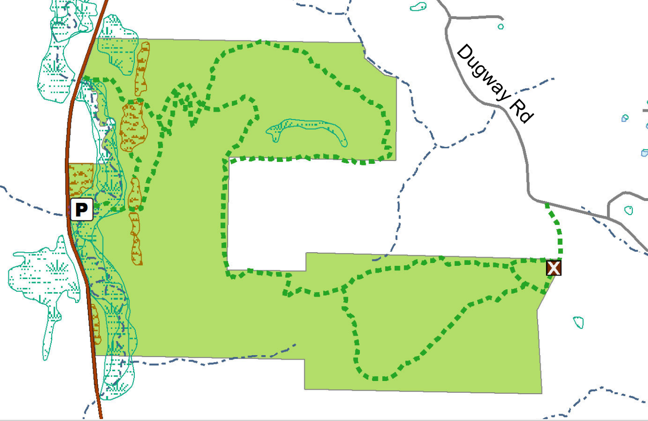 An alternative trail from the Stop sign goes to the right past a length of crash barrier across the path, and follows a broad trail up the hill (properly marked with paint dabs this time) deeper into the Stid Hill MUA. Both trails come together about a mile from the trail head.
Though the trails were well marked at one time, there hasn’t been much trail maintenance recently. The trail markers are difficult to follow and sometimes deceptive, and they disappear completely over the crown of the hill. The going will be very wet in places over the crown.
Tourists and Naturalists
For the tourists and Naturalists, there are loop trails starting at the Stop sign. The left and the right trails from the Stop sign are joined by linking trails through the woods. The paths are dry and in good shape here and marked with yellow or pink paint dabs.
Climbers
The climbers will hike all the way over Stid Hill and come down the steep escarpment to the more northerly Route 64 Stid Hill parking area. We’ll shuttle back to the Dugway Road trail head to collect the cars. The paint dabs start off yellow, but there a blue trail that parallels the yellow one and is easier to find. Here’s the route:
Once past the initial steep climb the trail is reasonably level until we come over the crown of the hill and start down the escarpment to Route 64. The trail markers run out pretty soon at the beginning of the walk, but the path is well trodden and easy to follow. It is however VERY WET! Wear good boots or get wet feet. It’s also very muddy in places. The section down the escarpment switchbacks a lot; it is steep, dry, and nicely wooded. The trail markers start up again as we start to come downhill again, but they get confusing and it’s easy to miss a sharp right turn to follow the borders of state land.
The Meeting Place
We will meet at the Dugway Road trail head at 1:45pm for a head count, and we’ll arrange to have some cars down at the Route 64 parking area for a ride back up the hill.
Getting There
Route 64 runs north-south, so there are only two direction of approach.
From the north, (Honeoye and Bloomfield) starting at Route 5 & 20 in Bloomfield, come down Route 64. 3.0 miles south of Rt 20A and 1.4 miles past Bristol Center (and CR 32), turn left on Dugway Road. If you come to a Stid Hill MUA parking area, you’ve come too far south – turn around and try again.
From the south, starting at Bristol Springs for 6.4 miles, come up Route 64 past both Stid Hill parking areas, then turn right on Dugway Road. If you come to Bristol Center you’ve come too far north.
From Springwater, Google Maps recommends heading north to 20A through Honeoye, then south on 64.
From Wayland, the recommendation is to take Rt 21 through Naples to the east end of Dugway Rd (4.5 miles north of the intersection with NY 64). The trail head is 1.2 miles west on Dugway, (Dugway is paved to the Bristol/Canandaigua town line).
Dugway Road is a good dirt road. The trail head is exactly 2.0 miles from the Route 64 junction. It’s easy to miss – it’s just a widening of the road after a sharp left turn. The trail head is on the right of the road and marked with a discreet sign a little too far from the road. Please park carefully. There isn’t much parking space to be had.
The Social
We’ll go to Lock Stock and Barrel on Route 64 just north of Bristol Mountain for the social after the hike. The climbers are likely to be about half an hour late so earlier arrivals should feel free to set up beers for them for when they finally get there.
Agenda
  Approve minutes – Katherine
    Please review the minutes prior to the meeting. Please look in the dropbox

  Treasurer’s report – Melissa

  Committee Reports
    Advertizing – Katherine
    Trail Maintenance – Gene
    Trail Building – Rick
    Bicentenial Committee – Wendy, Mark
    Hiking Group – Wendy
      Winter Hikes

  New Business

  Next Meeting
 Doors open at 7:30
Live Music by Howie Lester’s Party Band.
Caller: Jim Kimball
Donations accepted to benefit Save the Community Center
Come alone, with your favorite partner or with all your neighbors!
![]() It’s going to be an exciting Sunday, celebrating the Springwater Bicentennial. Events start at 10:00AM at the Springwater Fire Hall with a communal church service. Following the Service, a chicken BBQ with $9.00 chicken dinners with all the trimmings. At 1:00PM, the Waylandaires will perform, there will be birthday cake for Springwater, and expect some speeches from local and state representatives in town to celebrate with Springwater.
It’s going to be an exciting Sunday, celebrating the Springwater Bicentennial. Events start at 10:00AM at the Springwater Fire Hall with a communal church service. Following the Service, a chicken BBQ with $9.00 chicken dinners with all the trimmings. At 1:00PM, the Waylandaires will perform, there will be birthday cake for Springwater, and expect some speeches from local and state representatives in town to celebrate with Springwater.
Following the cake, Springwater Trails will meet in the Fire Hall parking lot for a walk through the hamlet of Springwater. All friends of Springwater looking to celebrate the town with a two hour walk around the hamlet are invited to join us.
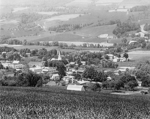
The Hamlet of Springwater from the north east hill. The intersection of Kellogg Rd and Depot Rd in the distance will be one of our hike goals. Photo courtesy of Joyce O’Neil via hemlockandcanadicelakes.com
We will visit Canute Park and the Springwater Creek, which drains the west hill of Springwater valley, and we will cross Limekiln Creek, which drains the east hill. A swing across Kellogg Rd marks the north edge of the hamlet. The hike will take two hours and we will return to the cars.
Bring old pictures of the hamlet, if you would like to share them as we hike. We are expecting a clear day with temperatures in the 60’s. Following the hike, we will gather at Canute Park for a pot luck social. Bring a dish to pass, and something to drink.
Looking for brochure.or mailing list so I can receive it in the mail.
Nothing opens up for mailing list.
There’s all kinds of very bizarre ads and post for viagra and other drugs above on calender page.
Please let me know if there’s a brochure available